
 Search
February 8, 2016 Snowfall Observations & Discussions
Page 15 of 20 •  1 ... 9 ... 14, 15, 16 ... 20
 ![]()
Re: February 8, 2016 Snowfall Observations & Discussions
![]() by sroc4 Mon Feb 08, 2016 7:41 am
by sroc4 Mon Feb 08, 2016 7:41 am
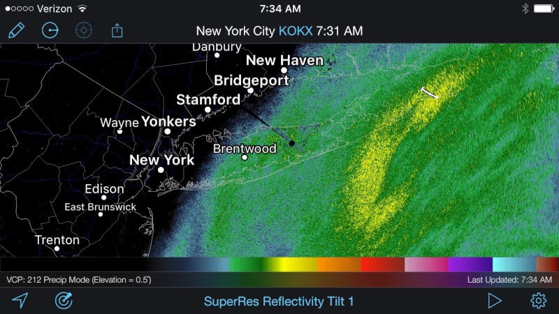
oldtimer wrote:34* Snowing very lightly Started 20 minutes ago SROC Will we get 5" out of this Don't look to impressive
oldtimer wrote:34* Snowing very lightly Started 20 minutes ago SROC Will we get 5" out of this Don't look to impressive
If we can get that band to move a little north and west and get it to park over us for a few hrs like it is over the south fork at the moment we could get 6-10". I've been in some mod snow now for about an hrs do all surfaces are covered. About 1/4 - 1/2" already. I think 4-8" west to east is def possible for Suffolk and even mor out on the twin forks.
sroc4- Admin

- Posts : 8331
Join date : 2013-01-07
Re: February 8, 2016 Snowfall Observations & Discussions
![]() by oldtimer Mon Feb 08, 2016 7:45 am
by oldtimer Mon Feb 08, 2016 7:45 am
oldtimer- Senior Enthusiast

- Posts : 1103
Join date : 2013-01-16
Re: February 8, 2016 Snowfall Observations & Discussions
![]() by NjWeatherGuy Mon Feb 08, 2016 8:00 am
by NjWeatherGuy Mon Feb 08, 2016 8:00 am

NjWeatherGuy- Advanced Forecaster

- Posts : 4100
Reputation : 28
Join date : 2013-01-06
Location : Belle Mead, NJ
Re: February 8, 2016 Snowfall Observations & Discussions
![]() by NjWeatherGuy Mon Feb 08, 2016 8:02 am
by NjWeatherGuy Mon Feb 08, 2016 8:02 am
http://www.goes.noaa.gov/browse2.html
NjWeatherGuy- Advanced Forecaster
- Posts : 4100
Reputation : 28
Join date : 2013-01-06
Location : Belle Mead, NJ
Re: February 8, 2016 Snowfall Observations & Discussions
![]() by CPcantmeasuresnow Mon Feb 08, 2016 8:06 am
by CPcantmeasuresnow Mon Feb 08, 2016 8:06 am
docstox12 wrote:snow247 wrote:docstox12 wrote:31.6, 78%, 29.52F
NWS has me up to 2 to 4 from only an inch last night.Radar shows most of the precip way east of me but slowly moving N and W.Better be a rapid expansion of this soon for that forecast to play out.Also, temp almost freezing here, got to be above freezing S and E of me.
Highly doubt we get 2 to 4 around here. Maybe an inch at best if we're lucky.
From the looks of that radar, I'd be surprised to get anything at all up here.
I agree, a few bursts of snow showers from a wandering band that makes if this far west to whiten the ground and that should be it, 2-4 would shock me, that's not happening.

CPcantmeasuresnow- Wx Statistician Guru

- Posts : 7274
Reputation : 230
Join date : 2013-01-07
Age : 103
Location : Eastern Orange County, NY
Re: February 8, 2016 Snowfall Observations & Discussions
![]() by jake732 Mon Feb 08, 2016 8:09 am
by jake732 Mon Feb 08, 2016 8:09 am

jake732- Pro Enthusiast

- Posts : 449
Reputation : 0
Join date : 2016-01-03
Location : lakewood, nj -

Re: February 8, 2016 Snowfall Observations & Discussions
![]() by Guest Mon Feb 08, 2016 8:12 am
by Guest Mon Feb 08, 2016 8:12 am
Guest- Guest
Re: February 8, 2016 Snowfall Observations & Discussions
![]() by amugs Mon Feb 08, 2016 8:13 am
by amugs Mon Feb 08, 2016 8:13 am
oldtimer wrote:34* Snowing very lightly Started 20 minutes ago SROC Will we get 5" out of this Don't look to impressive
Old Timer ANY SNOW IS GOOD SNOW - don't down play 5" whilst our HV bros & sistas are sucking cold and dry. Enjoy the white gold Paisan!!!
_________________
Mugs
AKA:King: Snow Weenie
Self Proclaimed
WINTER 2014-15 : 55.12" +.02 for 6 coatings (avg. 35")
WINTER 2015-16 Total - 29.8" (Avg 35")
WINTER 2016-17 : 39.5" so far

amugs- Advanced Forecaster - Mod

- Posts : 15093
Reputation : 213
Join date : 2013-01-07
Age : 54
Location : Hillsdale,NJ
Re: February 8, 2016 Snowfall Observations & Discussions
![]() by skinsfan1177 Mon Feb 08, 2016 8:16 am
by skinsfan1177 Mon Feb 08, 2016 8:16 am
Last edited by skinsfan1177 on Mon Feb 08, 2016 8:26 am; edited 1 time in total

skinsfan1177- Senior Enthusiast
- Posts : 4485
Reputation : 35
Join date : 2013-01-07
Age : 46
Location : Point Pleasant Boro
Re: February 8, 2016 Snowfall Observations & Discussions
![]() by sroc4 Mon Feb 08, 2016 8:16 am
by sroc4 Mon Feb 08, 2016 8:16 am
_________________
"In weather and in life, there's no winning and losing; there's only winning and learning."
WINTER 2012/2013 TOTALS 43.65"WINTER 2017/2018 TOTALS 62.85" WINTER 2022/2023 TOTALS 4.9"
WINTER 2013/2014 TOTALS 64.85"WINTER 2018/2019 TOTALS 14.25" WINTER 2023/2024 TOTALS 13.1"
WINTER 2014/2015 TOTALS 71.20"WINTER 2019/2020 TOTALS 6.35"
WINTER 2015/2016 TOTALS 35.00"WINTER 2020/2021 TOTALS 37.75"
WINTER 2016/2017 TOTALS 42.25"WINTER 2021/2022 TOTALS 31.65"

sroc4- Admin
- Posts : 8331
Reputation : 301
Join date : 2013-01-07
Location : Wading River, LI
Re: February 8, 2016 Snowfall Observations & Discussions
![]() by amugs Mon Feb 08, 2016 8:18 am
by amugs Mon Feb 08, 2016 8:18 am
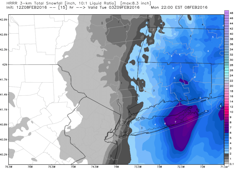
NEAR TERM /UNTIL 6 PM THIS EVENING/ NEAR TERM MESOSCALE UPDATE...BANDS OF MODERATE TO HEAVY SNOW ASSOCIATED WITH STRONG H7-5 FRONTOGENESIS ARE SPREADING ACROSS EASTERN LONG ISLAND AND SE CT...AND SHOULD CONTINUE SPREADING WESTWARD INTO MUCH OF THE REST OF THE AREA THROUGH THE MORNING. PRECIP COULD BE MIXED WITH RAIN AT THE VERY ONSET ALONG THE COAST...BUT THEN EVAPORATIVE/DYNAMIC COOLING FROM ALOFT SHOULD QUICKLY CHANGE PRECIP OVER TO SNOW. THE SNOW WILL BE HEAVY AT TIMES THIS MORNING ACROSS MUCH OF LONG ISLAND AND SOUTHERN CT...AND BASED ON RECENT RUNS OF THE RAP/HRRR...THE HEAVIEST SNOW BANDS SHOULD EVENTUALLY SET UP OVER CENTRAL SUFFOLK COUNTY NORTHWARD INTO NEW LONDON...MIDDLESEX AND EASTERN NEW HAVEN COUNTIES LATER THIS MORNING INTO THE EARLY AFTERNOON. EXPANDED WINTER STORM WARNING TO NEW HAVEN COUNTY EARLIER...AND ALSO INCREASED TOTALS WHERE THE HEAVIEST SNOW BANDS ARE EXPECTED...WITH 8-10 INCHES POSSIBLE AS BOTH LIFT AND DENDRITIC SNOW GROWTH ARE MAXIMIZED. WITH NE WINDS GUSTING TO 35 MPH NEAR BLIZZARD CONDS ARE LIKELY...ESPECIALLY ACROSS THE FORKS AND COASTAL SE CT. THE COMBO OF STRONG WINDS AND HEAVY SNOW COULD ALSO RESULT IN DOWNED TREES AND POWER LINES. FARTHER WEST...SNOW SHOULD BE ON THE LIGHT SIDE...WITH LIFT GENERATED A MID LEVEL SHORTWAVE APPROACHING FROM THE WEST AND THE RIGHT REAR QUAD OF AN UPPER JET STREAK OVER INTERIOR PA/NY. THESE AREAS SHOULD SEE A GENERAL 1-3 OR 2-4 INCH SNOWFALL...AND EXPANDED WINTER WX ADVY WESTWARD TO COVER ALL BUT ORANGE AND WESTERN PASSAIC COUNTIES. TEMPS AFTER SNOW BEGINS WILL FALL TO NEAR FREEZING...THEN BEGIN TO SLOWLY FALL THIS AFTERNOON.
Slowly Rotating to the City and NNJ

_________________
Mugs
AKA:King: Snow Weenie
Self Proclaimed
WINTER 2014-15 : 55.12" +.02 for 6 coatings (avg. 35")
WINTER 2015-16 Total - 29.8" (Avg 35")
WINTER 2016-17 : 39.5" so far
amugs- Advanced Forecaster - Mod
- Posts : 15093
Reputation : 213
Join date : 2013-01-07
Age : 54
Location : Hillsdale,NJ
Re: February 8, 2016 Snowfall Observations & Discussions
![]() by sroc4 Mon Feb 08, 2016 8:30 am
by sroc4 Mon Feb 08, 2016 8:30 am
_________________
"In weather and in life, there's no winning and losing; there's only winning and learning."
WINTER 2012/2013 TOTALS 43.65"WINTER 2017/2018 TOTALS 62.85" WINTER 2022/2023 TOTALS 4.9"
WINTER 2013/2014 TOTALS 64.85"WINTER 2018/2019 TOTALS 14.25" WINTER 2023/2024 TOTALS 13.1"
WINTER 2014/2015 TOTALS 71.20"WINTER 2019/2020 TOTALS 6.35"
WINTER 2015/2016 TOTALS 35.00"WINTER 2020/2021 TOTALS 37.75"
WINTER 2016/2017 TOTALS 42.25"WINTER 2021/2022 TOTALS 31.65"
sroc4- Admin
- Posts : 8331
Reputation : 301
Join date : 2013-01-07
Location : Wading River, LI
Re: February 8, 2016 Snowfall Observations & Discussions
![]() by amugs Mon Feb 08, 2016 8:41 am
by amugs Mon Feb 08, 2016 8:41 am
_________________
Mugs
AKA:King: Snow Weenie
Self Proclaimed
WINTER 2014-15 : 55.12" +.02 for 6 coatings (avg. 35")
WINTER 2015-16 Total - 29.8" (Avg 35")
WINTER 2016-17 : 39.5" so far
amugs- Advanced Forecaster - Mod
- Posts : 15093
Reputation : 213
Join date : 2013-01-07
Age : 54
Location : Hillsdale,NJ
Re: February 8, 2016 Snowfall Observations & Discussions
![]() by docstox12 Mon Feb 08, 2016 8:41 am
by docstox12 Mon Feb 08, 2016 8:41 am
sroc4 wrote:Very Sharp cutoffs to the west however. I posted that earlier Mugs. It was the 5:15am update. Im not so sure about western areas.
Wow.Radar looked like that to me hours ago.There is a brick wall again at the Hudson River.Reminds me of Juno.

docstox12- Wx Statistician Guru
- Posts : 8507
Reputation : 222
Join date : 2013-01-07
Age : 73
Location : Monroe NY
Re: February 8, 2016 Snowfall Observations & Discussions
![]() by amugs Mon Feb 08, 2016 8:47 am
by amugs Mon Feb 08, 2016 8:47 am

Look at this - are u fricking kiddin me!!
_________________
Mugs
AKA:King: Snow Weenie
Self Proclaimed
WINTER 2014-15 : 55.12" +.02 for 6 coatings (avg. 35")
WINTER 2015-16 Total - 29.8" (Avg 35")
WINTER 2016-17 : 39.5" so far
amugs- Advanced Forecaster - Mod
- Posts : 15093
Reputation : 213
Join date : 2013-01-07
Age : 54
Location : Hillsdale,NJ
Re: February 8, 2016 Snowfall Observations & Discussions
![]() by CPcantmeasuresnow Mon Feb 08, 2016 8:49 am
by CPcantmeasuresnow Mon Feb 08, 2016 8:49 am
amugs wrote:DOC exactly!!!!!! Look a thi scrap - I am going to drive myself up a wall with this today as this storm hits teh same wall I am driving my 46 yr old physique into!!!
Look at this - are u fricking kiddin me!!
I have to visit a client in New Hyde park today, this may be a problem.
CPcantmeasuresnow- Wx Statistician Guru
- Posts : 7274
Reputation : 230
Join date : 2013-01-07
Age : 103
Location : Eastern Orange County, NY
Re: February 8, 2016 Snowfall Observations & Discussions
![]() by Vinnydula Mon Feb 08, 2016 8:52 am
by Vinnydula Mon Feb 08, 2016 8:52 am

Vinnydula- Pro Enthusiast
- Posts : 778
Reputation : 8
Join date : 2013-12-12
Location : Dobbs ferry
Re: February 8, 2016 Snowfall Observations & Discussions
![]() by docstox12 Mon Feb 08, 2016 8:52 am
by docstox12 Mon Feb 08, 2016 8:52 am
docstox12- Wx Statistician Guru
- Posts : 8507
Reputation : 222
Join date : 2013-01-07
Age : 73
Location : Monroe NY
Re: February 8, 2016 Snowfall Observations & Discussions
![]() by hyde345 Mon Feb 08, 2016 8:53 am
by hyde345 Mon Feb 08, 2016 8:53 am

hyde345- Pro Enthusiast
- Posts : 1082
Reputation : 48
Join date : 2013-01-08
Location : Hyde Park, NY
Re: February 8, 2016 Snowfall Observations & Discussions
![]() by docstox12 Mon Feb 08, 2016 8:54 am
by docstox12 Mon Feb 08, 2016 8:54 am
hyde345 wrote:HV on western edge of precip. What a shocker. I said days ago that the big storm would come close enough to give us close to nothing and screw us further as IVT sets up further south. This is the Murphy's Law of winter 2015-2016 in HV. I still hope to squeeze out 1-2 inches by Thursday so I don't have to look at green grass in February.
30 to 1 shot on that IVT coming up here the way our luck has been running this year.
docstox12- Wx Statistician Guru
- Posts : 8507
Reputation : 222
Join date : 2013-01-07
Age : 73
Location : Monroe NY
Re: February 8, 2016 Snowfall Observations & Discussions
![]() by essexcountypete Mon Feb 08, 2016 9:03 am
by essexcountypete Mon Feb 08, 2016 9:03 am

essexcountypete- Pro Enthusiast
- Posts : 783
Reputation : 12
Join date : 2013-12-09
Location : Bloomfield, NJ

snow247- Pro Enthusiast
- Posts : 2417
Reputation : 0
Join date : 2014-08-27
Location : Mount Ivy, NY - Elevation 545'
Re: February 8, 2016 Snowfall Observations & Discussions
![]() by docstox12 Mon Feb 08, 2016 9:07 am
by docstox12 Mon Feb 08, 2016 9:07 am
Tick--tock,tick--tock....time is passing.Radar still looks bad for the HV.Precip moving north but not west.That is all.......
docstox12- Wx Statistician Guru
- Posts : 8507
Reputation : 222
Join date : 2013-01-07
Age : 73
Location : Monroe NY
Re: February 8, 2016 Snowfall Observations & Discussions
![]() by Taffy Mon Feb 08, 2016 9:13 am
by Taffy Mon Feb 08, 2016 9:13 am
Wind 15
Humidity 61
Precipitation a big fat 0

Taffy- Pro Enthusiast
- Posts : 530
Reputation : 19
Join date : 2013-10-06
Location : Hopkinton, MA
Re: February 8, 2016 Snowfall Observations & Discussions
![]() by algae888 Mon Feb 08, 2016 9:15 am
by algae888 Mon Feb 08, 2016 9:15 am

algae888- Advanced Forecaster
- Posts : 5311
Reputation : 46
Join date : 2013-02-05
Age : 61
Location : mt. vernon, new york
Re: February 8, 2016 Snowfall Observations & Discussions
![]() by frank 638 Mon Feb 08, 2016 9:15 am
by frank 638 Mon Feb 08, 2016 9:15 am
frank 638- Senior Enthusiast
- Posts : 2825
Reputation : 37
Join date : 2016-01-01
Age : 40
Location : bronx ny
Re: February 8, 2016 Snowfall Observations & Discussions
![]() by Vinnydula Mon Feb 08, 2016 9:18 am
by Vinnydula Mon Feb 08, 2016 9:18 am
Vinnydula- Pro Enthusiast
- Posts : 778
Reputation : 8
Join date : 2013-12-12
Location : Dobbs ferry
Page 15 of 20 • 1 ... 9 ... 14, 15, 16 ... 20 ![]()
|
|
|