Hurricane Hermine Discussion Part 2
+42
WeatherJeff1224
Dunnzoo
Mathgod55
jake732
track17
lisalamb
Artechmetals
GreyBeard
RJB8525
Cyanide02Z06
jwalsh
hyde345
Dtone
Chris3379
Quietace
docstox12
algae888
billg315
pdubz
SoulSingMG
Snow88
oldtimer
HectorO
Joe Snow
NjWeatherGuy
frank 638
aiannone
Grselig
roccuweather
sroc4
WeatherBob
Math23x7
snow247
nutleyblizzard
jmanley32
amugs
Frank_Wx
weatherwatchermom
rb924119
dsix85
skinsfan1177
Sanchize06
46 posters
Page 14 of 35
Page 14 of 35 •  1 ... 8 ... 13, 14, 15 ... 24 ... 35
 Re: Hurricane Hermine Discussion Part 2
hey frank will we do a live chat tonight?
weatherwatchermom- Senior Enthusiast

- Posts : 3750
Join date : 2014-11-25
 Re: Hurricane Hermine Discussion Part 2
Looks like people are getting the message to leave.


Cyanide02Z06- Posts : 23
Join date : 2015-01-25

snow247- Pro Enthusiast

- Posts : 2417
Reputation : 0
Join date : 2014-08-27
Location : Mount Ivy, NY - Elevation 545'
 Re: Hurricane Hermine Discussion Part 2
Rain shower with continued gusty winds although it looks like the sustained winds are down to 17 mph at the moment. You can visually see we are on the edge of this thing. If you look west over the bay the sky is cloudy but light. If you look east the clouds are dark and angry. Haha.

billg315- Advanced Forecaster - Mod

- Posts : 4469
Reputation : 185
Join date : 2015-01-24
Age : 50
Location : Flemington, NJ
 Re: Hurricane Hermine Discussion Part 2
Just saw the rgem. Its impressive. gets hermine down to 980mb and retrogrades very close to South jersey shore and eastern Maryland. 850 wind about 75 knots over Southern New Jersey Delaware and Maryland however not seeing stronger winds down at the surface. I think the lack of rain and convection is hindering stronger wind gusts mixing down to the surface. something to consider going forward
Last edited by algae888 on Sat Sep 03, 2016 11:34 am; edited 1 time in total

algae888- Advanced Forecaster

- Posts : 5311
Reputation : 46
Join date : 2013-02-05
Age : 61
Location : mt. vernon, new york
 Re: Hurricane Hermine Discussion Part 2
What did the GFS surface initialize at? Looks like near 1,000 or 998 mb?

WeatherBob- Meteorologist

- Posts : 683
Reputation : 83
Join date : 2013-12-13
Location : Caldwell, NJ - NW Essex County - Altitude 500 FT
 Re: Hurricane Hermine Discussion Part 2
jwalsh wrote:What does the water temp. look like SE of NJ/LI in the Atlantic? Is it favorable for intensification once Hermine stalls, possibly creating hurricane-force sustained winds?
Water temps are well above normal this time of year. I think they're in the 70s, and near 80 around VA. Hurricane force sustained winds are possible along the shores but for everyone else looking at Tropical Storm strength.
weatherwatchermom wrote:hey frank will we do a live chat tonight?
I'm trying to find a new way to do live chats. I don't like the one this forum offers. Becomes difficult to read with people who time out, etc.
_________________
_______________________________________________________________________________________________________
CLICK HERE to view NJ Strong Snowstorm Classifications
 Re: Hurricane Hermine Discussion Part 2
Funny I came into town last night and parking was non-existent. Plenty of parking now. Lol. I'm trying to determine when I'm going to leave. Right now SIC PD is reporting a backup on the Parkway. So I'm not sure if that gets worse or if it gets better after everyone has cleared out.

billg315- Advanced Forecaster - Mod

- Posts : 4469
Reputation : 185
Join date : 2015-01-24
Age : 50
Location : Flemington, NJ
 Re: Hurricane Hermine Discussion Part 2
Just went on twitter, flooding already occurring from cape may up to Barn. peninsula.

Quietace- Meteorologist - Mod

- Posts : 3687
Reputation : 33
Join date : 2013-01-07
Age : 27
Location : Point Pleasant, NJ
 Re: Hurricane Hermine Discussion Part 2
http://www.surfline.com/surf-report/manasquan-mid-atlantic_4278/

Quietace- Meteorologist - Mod

- Posts : 3687
Reputation : 33
Join date : 2013-01-07
Age : 27
Location : Point Pleasant, NJ
 Re: Hurricane Hermine Discussion Part 2
Reporting high sustained winds in Bradley Beach. Already seeing significant beach erosion. Town removed all garbage cans and rubber walkways from the beach last night and have moved lifeguard chairs up towards the dunes. Waves aren't very high, but ocean is churned up really good.

roccuweather- Posts : 37
Reputation : 0
Join date : 2014-03-01
Location : Bradley Beach, NJ
 Re: Hurricane Hermine Discussion Part 2
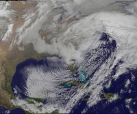
Major differences between the GFS and NAM at 42 hours, NAM is very close to the coast while the GFS is well, not, pretty much holds serve which makes me think the NAM is wrong.
NjWeatherGuy- Advanced Forecaster

- Posts : 4100
Reputation : 28
Join date : 2013-01-06
Location : Belle Mead, NJ
 Re: Hurricane Hermine Discussion Part 2
Not hyping but same thing happened with Sandy with the flooding
_________________
Mugs
AKA:King: Snow Weenie
Self Proclaimed
WINTER 2014-15 : 55.12" +.02 for 6 coatings (avg. 35")
WINTER 2015-16 Total - 29.8" (Avg 35")
WINTER 2016-17 : 39.5" so far

amugs- Advanced Forecaster - Mod

- Posts : 15093
Reputation : 213
Join date : 2013-01-07
Age : 54
Location : Hillsdale,NJ
 Re: Hurricane Hermine Discussion Part 2
GFS still underestimating surface pressure. At 15z has about 1000mb low when its actually 993mb with low over open water.

hyde345- Pro Enthusiast

- Posts : 1082
Reputation : 48
Join date : 2013-01-08
Location : Hyde Park, NY
 Re: Hurricane Hermine Discussion Part 2
I don't think the rain will be an issue with this storm unless every model shifts northwest throughout the day

Snow88- Senior Enthusiast

- Posts : 2193
Reputation : 4
Join date : 2013-01-09
Age : 35
Location : Brooklyn, NY
 Re: Hurricane Hermine Discussion Part 2
5-7' waves confirmed on LBI. Pre-existing beach erosion of about 3-4' has now increased to 4-5'.
rb924119- Meteorologist

- Posts : 6890
Reputation : 194
Join date : 2013-02-06
Age : 32
Location : Greentown, Pa
 Re: Hurricane Hermine Discussion Part 2
Hey guys. See wind chsnces upped to 80 percent in nj and 70 inlsnd. Ts warnings up. The way they write them is odd I can't seem to understand what winds they expect 39 to 73mph big range. Anyways what's the thinking up here. It is getting breezy as moring has progressed.

jmanley32- Senior Enthusiast

- Posts : 20517
Reputation : 108
Join date : 2013-12-12
Age : 42
Location : Yonkers, NY
 Re: Hurricane Hermine Discussion Part 2
Also note cone now has 3 hurricane dots noting longer hurricane status. This could still stay west it's really a now at imo.

jmanley32- Senior Enthusiast

- Posts : 20517
Reputation : 108
Join date : 2013-12-12
Age : 42
Location : Yonkers, NY
 Re: Hurricane Hermine Discussion Part 2
Tom, what are your thoughts on the 12Z RGEM?
Math23x7- Wx Statistician Guru

- Posts : 2379
Reputation : 68
Join date : 2013-01-08
 Re: Hurricane Hermine Discussion Part 2
It looks like in the end the GFS does the same as the NAM, bringing the remnants very close to the coast but its over 1000mb and not much left by then. Still find the evolution portrayed by these two runs very interesting, especially considering they end up in near the exact same spot, but in between far different and far different implications.

NjWeatherGuy- Advanced Forecaster

- Posts : 4100
Reputation : 28
Join date : 2013-01-06
Location : Belle Mead, NJ
 Re: Hurricane Hermine Discussion Part 2
GFS seems to give us a limited blow. Looks like a south jersey to va capes storm. However, the high tides and rip currents will be the threat throughout nyc metro down the shore. That's what it looks like to me on this model.

WeatherBob- Meteorologist

- Posts : 683
Reputation : 83
Join date : 2013-12-13
Location : Caldwell, NJ - NW Essex County - Altitude 500 FT
 Re: Hurricane Hermine Discussion Part 2
Here's the moral of the story:
1. Very little rain impact for most, including the coast. Shores could see 1-2 inches of rain which is not a big deal. Everyone inland will see little to no rain. Dry air will wrap into the storm and prevent any convective banding from moving onshore, though coastal areas could still see heavy banding.
2. Winds along the coast will be sustained 35-45mph with gusts reaching 70mph at times. I wouldn't be shocked if someone recorded hurricane force winds at 75mph. Winds away from the coast will be sustained 25-35mph with gusts exceeding 50mph at times. There could be a period of time where winds are consistently above 40mph and that could lead to isolated power outages.
3. Coastal flooding is the main takeaway. Some towns in SNJ are already seeing it. Surge of 4-6 feet is expected up and down NJ into LI too. In conjunction with the tropical storm force winds that is not a pleasant situation. If you live on the shore I would prepare for flooding and power outages now just in case.
Overall, Hermine does not look like it will take a westerly turn once it gets 50-75 miles east of NJ. It may spin and stall, but that's different then physically tracking due west which would have been disastrous for the area. We're catching a huge break.
If anything changes with modeling today that would make me think the above forecast needs to be updated I will let you know. For now, that's my forecast.
Edit:
Timing is Sunday afternoon through Wednesday afternoon. Yes, that's almost 4 days of high winds and dangerous surge. Consider this, that's like 8 high tide cycles Hermine has to work with. We'll begin to clear by Thursday when another heat wave is set to warm the area. Just remember...4 days! Worst of it will be Monday and Tuesday.
Last edited by Frank_Wx on Sat Sep 03, 2016 12:06 pm; edited 1 time in total
_________________
_______________________________________________________________________________________________________
CLICK HERE to view NJ Strong Snowstorm Classifications
 Re: Hurricane Hermine Discussion Part 2
That will have a major impact on Surface wind speeds with no conviction expect winds under guidanceSnow88 wrote:I don't think the rain will be an issue with this storm unless every model shifts northwest throughout the day

algae888- Advanced Forecaster

- Posts : 5311
Reputation : 46
Join date : 2013-02-05
Age : 61
Location : mt. vernon, new york
 Re: Hurricane Hermine Discussion Part 2
NjWeatherGuy , good evaluation!

WeatherBob- Meteorologist

- Posts : 683
Reputation : 83
Join date : 2013-12-13
Location : Caldwell, NJ - NW Essex County - Altitude 500 FT
 Re: Hurricane Hermine Discussion Part 2
NWS:
"There is a danger of life-threatening inundation in the next 36 hours from Chincoteague, VA to Sandy Hook, NJ and in the next 48 hours from Sandy Hook, NJ to Bridgeport, CT."
"There is a danger of life-threatening inundation in the next 36 hours from Chincoteague, VA to Sandy Hook, NJ and in the next 48 hours from Sandy Hook, NJ to Bridgeport, CT."

SoulSingMG- Senior Enthusiast

- Posts : 2853
Reputation : 74
Join date : 2013-12-11
Location : Long Island City, NY
 Re: Hurricane Hermine Discussion Part 2
OK, seems like the forecast is loaded, locked and just fired! 


WeatherBob- Meteorologist

- Posts : 683
Reputation : 83
Join date : 2013-12-13
Location : Caldwell, NJ - NW Essex County - Altitude 500 FT
 Re: Hurricane Hermine Discussion Part 2
At this time nhc calling for ts force winds al I'm sure they consider the convection lacking. But we will see. Getting a light breeze now. Maybe it won't b up to 73 mph but ts force is 39 to 73mph sustained which is still high enough to cause msinly tree and line damage.

jmanley32- Senior Enthusiast

- Posts : 20517
Reputation : 108
Join date : 2013-12-12
Age : 42
Location : Yonkers, NY
Page 14 of 35 •  1 ... 8 ... 13, 14, 15 ... 24 ... 35
Page 14 of 35
Permissions in this forum:
You cannot reply to topics in this forum|
|
|

 Home
Home
