
 Search
Monday 12/5 Snow Showers Discussion / Observations
Page 2 of 3 •  1, 2, 3
 ![]()

Frank_Wx- Godzilla Seeker

- Posts : 21305
Join date : 2013-01-05 -

Re: Monday 12/5 Snow Showers Discussion / Observations
![]() by Frank_Wx Sun Dec 04, 2016 7:38 pm
by Frank_Wx Sun Dec 04, 2016 7:38 pm

Frank_Wx- Godzilla Seeker
- Posts : 21305
Join date : 2013-01-05 -
Re: Monday 12/5 Snow Showers Discussion / Observations
![]() by Guest Sun Dec 04, 2016 7:42 pm
by Guest Sun Dec 04, 2016 7:42 pm
Also its 35 degrees here at 7:30. we are expecting rain after midnight??????????? Usually the column and temperature goes down at night, especially as we wet bulb no???
Guest- Guest
Re: Monday 12/5 Snow Showers Discussion / Observations
![]() by Frank_Wx Sun Dec 04, 2016 7:44 pm
by Frank_Wx Sun Dec 04, 2016 7:44 pm

The 925mb isotherm nicely follows where the r/s line is. This isotherm was solidly more S&E a couple of days ago.
_________________
_______________________________________________________________________________________________________
CLICK HERE to view NJ Strong Snowstorm Classifications

Frank_Wx- Godzilla Seeker
- Posts : 21305
Reputation : 328
Join date : 2013-01-05
Age : 31
Location : Jersey City, NJ -
Re: Monday 12/5 Snow Showers Discussion / Observations
![]() by Frank_Wx Sun Dec 04, 2016 7:46 pm
by Frank_Wx Sun Dec 04, 2016 7:46 pm
syosnow94 wrote:I can't believe all the "excitement" for an inch or 2 of snow.
Also its 35 degrees here at 7:30. we are expecting rain after midnight??????????? Usually the column and temperature goes down at night, especially as we wet bulb no???
Winds are from the NE shifting from the south. Normally our snow events have a west-northwest wind.
_________________
_______________________________________________________________________________________________________
CLICK HERE to view NJ Strong Snowstorm Classifications
Frank_Wx- Godzilla Seeker
- Posts : 21305
Reputation : 328
Join date : 2013-01-05
Age : 31
Location : Jersey City, NJ -
Re: Monday 12/5 Snow Showers Discussion / Observations
![]() by Math23x7 Sun Dec 04, 2016 7:50 pm
by Math23x7 Sun Dec 04, 2016 7:50 pm
syosnow94 wrote:I can't believe all the "excitement" for an inch or 2 of snow.
Also its 35 degrees here at 7:30. we are expecting rain after midnight??????????? Usually the column and temperature goes down at night, especially as we wet bulb no???
Looking at guidance, the is no low pressure off the coast; the low is in the great lakes region passing us to our north. Also, there is no big high pressure to our north and west; there are high pressures in the South and to our east. Throw in the fact the the water temperatures are around 50 degrees near the coast. All of this means rain for the I-95 corridor.
Math23x7- Wx Statistician Guru

- Posts : 2379
Reputation : 68
Join date : 2013-01-08
Re: Monday 12/5 Snow Showers Discussion / Observations
![]() by Frank_Wx Sun Dec 04, 2016 7:56 pm
by Frank_Wx Sun Dec 04, 2016 7:56 pm
Math23x7 wrote:syosnow94 wrote:I can't believe all the "excitement" for an inch or 2 of snow.
Also its 35 degrees here at 7:30. we are expecting rain after midnight??????????? Usually the column and temperature goes down at night, especially as we wet bulb no???
Looking at guidance, the is no low pressure off the coast; the low is in the great lakes region passing us to our north. Also, there is no big high pressure to our north and west; there are high pressures in the South and to our east. Throw in the fact the the water temperatures are around 50 degrees near the coast. All of this means rain for the I-95 corridor.
Good post
_________________
_______________________________________________________________________________________________________
CLICK HERE to view NJ Strong Snowstorm Classifications
Frank_Wx- Godzilla Seeker
- Posts : 21305
Reputation : 328
Join date : 2013-01-05
Age : 31
Location : Jersey City, NJ -
Re: Monday 12/5 Snow Showers Discussion / Observations
![]() by rb924119 Sun Dec 04, 2016 8:11 pm
by rb924119 Sun Dec 04, 2016 8:11 pm
Start: 11pm-2am
End: 9am-12pm
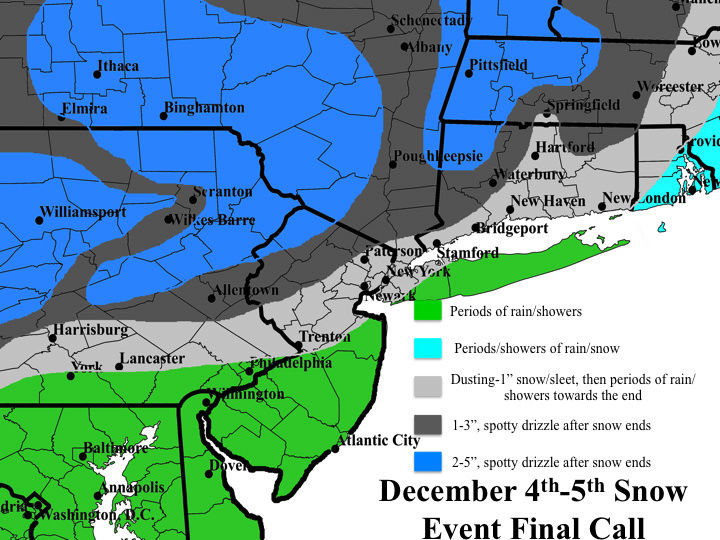
It's basically unchanged from my first call yesterday, but I didn't feel that "1-3", locally higher amounts" was going to adequately cover the range here, mainly in the higher elevations, which is why I have the blue, 2-5" regions. I admit that I think most locations in these areas will be in the 2-3/3.5" range, but I wanted to account for the possibility of another over performance and lollipop amounts in excess of 4". I know this seems very high, but I had a post that detailed my thoughts about this event. Since that post (if you want me to find it, just let me know and I'll post the link), the forcing mechanisms that I outlined actually have trended a bit stronger in my opinion; mainly with respect to the lower-level warm advection/isentropic/upglide forcings. I also noticed that instead of having a split-flow of advection, where this system would have air originating around the Tennessee Valley, there is now broad agreement that there will be a fetch with origins in the northern Gulf. Although I don't believe that air will entirely make it this far north in time, the fact that there is more of a southerly fetch ahead of this system as it arrives into our region versus what was earlier progged to be more southwesterly, leads me to believe that another over performance is at the very least plausible.
In addition, I also believe that the regions in blue will see dendrites and hexagonal plates as snowflake structures based on the thermal profiles, and with lower-level profiles between 0 and -5°C through the precipitation-formation layer, there is strong support for aggregate snowflakes (what I call chicken feathers). Because of this, I think the snow will stack up quick once it starts falling, especially since many of these regions are already below freezing, so snow will not be lost to melting. I think snowfall rates could reach or eclipse 1"/hr at times in these regions, which also supports my map. Secondly, this is also a test for me. I am playing a hunch by going higher here, a hunch that I had last time but never pulled the trigger on. I'm taking the shot this time, and if no lollipop amounts verify, oh well, because I still strongly believe that the low of end of that range is going to verify in those regions, with my other regions also still on track. We'll see. Discuss!!
Last edited by rb924119 on Sun Dec 04, 2016 8:16 pm; edited 1 time in total
rb924119- Meteorologist

- Posts : 6889
Reputation : 194
Join date : 2013-02-06
Age : 32
Location : Greentown, Pa
Re: Monday 12/5 Snow Showers Discussion / Observations
![]() by Frank_Wx Sun Dec 04, 2016 8:15 pm
by Frank_Wx Sun Dec 04, 2016 8:15 pm

_________________
_______________________________________________________________________________________________________
CLICK HERE to view NJ Strong Snowstorm Classifications
Frank_Wx- Godzilla Seeker
- Posts : 21305
Reputation : 328
Join date : 2013-01-05
Age : 31
Location : Jersey City, NJ -
Re: Monday 12/5 Snow Showers Discussion / Observations
![]() by rb924119 Sun Dec 04, 2016 8:21 pm
by rb924119 Sun Dec 04, 2016 8:21 pm
Frank_Wx wrote:Ray - 700mb frontogenesis seems decent over your blue shaded areas, but not much vertical velocity to work with. Also, the jet streak seems unfavorably positioned.
I know; these are points that were brought up the other day. My argument is that because you are working with a long fetch of warm advection, the vertical velocities at any one layer WILL NOT be impressive, but you don't need them to be because you are forcing the air to rise regardless; just over a longer distance. Strong vertical velocities are usually associated with forcings that are very concentrated. In this case, the forcings are much more spread out, but still working constructively. Don't forget, even if the air we get originates in Virginia, it still has a higher water content than our air, so you don't need as much vertical velocity to force condensation and precipitation formation. But the jet streak, you're absolutely right; all of the forcing is sub-300hPa. I just think the other levels will compensate.
rb924119- Meteorologist
- Posts : 6889
Reputation : 194
Join date : 2013-02-06
Age : 32
Location : Greentown, Pa
Re: Monday 12/5 Snow Showers Discussion / Observations
![]() by Frank_Wx Sun Dec 04, 2016 8:28 pm
by Frank_Wx Sun Dec 04, 2016 8:28 pm
_________________
_______________________________________________________________________________________________________
CLICK HERE to view NJ Strong Snowstorm Classifications
Frank_Wx- Godzilla Seeker
- Posts : 21305
Reputation : 328
Join date : 2013-01-05
Age : 31
Location : Jersey City, NJ -
Re: Monday 12/5 Snow Showers Discussion / Observations
![]() by rb924119 Sun Dec 04, 2016 8:36 pm
by rb924119 Sun Dec 04, 2016 8:36 pm

rb924119- Meteorologist
- Posts : 6889
Reputation : 194
Join date : 2013-02-06
Age : 32
Location : Greentown, Pa
Re: Monday 12/5 Snow Showers Discussion / Observations
![]() by Frank_Wx Sun Dec 04, 2016 8:37 pm
by Frank_Wx Sun Dec 04, 2016 8:37 pm
Precip looks a little ragged.
.thumb.gif.78f453949b95b53c2c11c926a3573c53.gif)
_________________
_______________________________________________________________________________________________________
CLICK HERE to view NJ Strong Snowstorm Classifications
Frank_Wx- Godzilla Seeker
- Posts : 21305
Reputation : 328
Join date : 2013-01-05
Age : 31
Location : Jersey City, NJ -
Re: Monday 12/5 Snow Showers Discussion / Observations
![]() by rb924119 Sun Dec 04, 2016 8:41 pm
by rb924119 Sun Dec 04, 2016 8:41 pm
Frank_Wx wrote:Hey, it's a minor event. Whatever happens I would not get too high or down on it. The only impact this storm will have is the timing is morning rush hour. JOY!
Precip looks a little ragged.
It does, but I think it looks a little healthier in between the two fetches than it did a few hours ago. I think it will start looking better as we get deeper into the night. I HOPE it does
rb924119- Meteorologist
- Posts : 6889
Reputation : 194
Join date : 2013-02-06
Age : 32
Location : Greentown, Pa
Re: Monday 12/5 Snow Showers Discussion / Observations
![]() by Frank_Wx Sun Dec 04, 2016 8:52 pm
by Frank_Wx Sun Dec 04, 2016 8:52 pm

_________________
_______________________________________________________________________________________________________
CLICK HERE to view NJ Strong Snowstorm Classifications
Frank_Wx- Godzilla Seeker
- Posts : 21305
Reputation : 328
Join date : 2013-01-05
Age : 31
Location : Jersey City, NJ -
Re: Monday 12/5 Snow Showers Discussion / Observations
![]() by rb924119 Sun Dec 04, 2016 8:59 pm
by rb924119 Sun Dec 04, 2016 8:59 pm
rb924119- Meteorologist
- Posts : 6889
Reputation : 194
Join date : 2013-02-06
Age : 32
Location : Greentown, Pa
Re: Monday 12/5 Snow Showers Discussion / Observations
![]() by hyde345 Sun Dec 04, 2016 9:36 pm
by hyde345 Sun Dec 04, 2016 9:36 pm
syosnow94 wrote:I can't believe all the "excitement" for an inch or 2 of snow.
Also its 35 degrees here at 7:30. we are expecting rain after midnight??????????? Usually the column and temperature goes down at night, especially as we wet bulb no???
Because when you live in the Hudson Valley and your snowfall total last year was 6 inches and most of that fell in April any snow is a big deal.

hyde345- Pro Enthusiast

- Posts : 1082
Reputation : 48
Join date : 2013-01-08
Location : Hyde Park, NY
Re: Monday 12/5 Snow Showers Discussion / Observations
![]() by Frank_Wx Sun Dec 04, 2016 9:40 pm
by Frank_Wx Sun Dec 04, 2016 9:40 pm
hyde345 wrote:syosnow94 wrote:I can't believe all the "excitement" for an inch or 2 of snow.
Also its 35 degrees here at 7:30. we are expecting rain after midnight??????????? Usually the column and temperature goes down at night, especially as we wet bulb no???
Because when you live in the Hudson Valley and your snowfall total last year was 6 inches and most of that fell in April any snow is a big deal.

_________________
_______________________________________________________________________________________________________
CLICK HERE to view NJ Strong Snowstorm Classifications
Frank_Wx- Godzilla Seeker
- Posts : 21305
Reputation : 328
Join date : 2013-01-05
Age : 31
Location : Jersey City, NJ -
Re: Monday 12/5 Snow Showers Discussion / Observations
![]() by amugs Sun Dec 04, 2016 10:08 pm
by amugs Sun Dec 04, 2016 10:08 pm
NATIONAL WEATHER SERVICE MOUNT HOLLY NJ
922 PM EST SUN DEC 4 2016
NJZ001-007>009-PAZ054-055-060>062-105-050900-
SUSSEX-WARREN-MORRIS-HUNTERDON-CARBON-MONROE-BERKS-LEHIGH-
NORTHAMPTON-UPPER BUCKS-
INCLUDING THE CITIES OF...NEWTON...WASHINGTON...MORRISTOWN...
FLEMINGTON...JIM THORPE...STROUDSBURG...READING...ALLENTOWN...
BETHLEHEM...EASTON...CHALFONT...PERKASIE
922 PM EST SUN DEC 4 2016
...SNOW EXPECTED OVERNIGHT...
A QUICK MOVING STORM SYSTEM WILL IMPACT THE SOUTHERN POCONOS...NORTHERN
NEW JERSEY AND PARTS OF THE LEHIGH VALLEY OVERNIGHT. SNOW WILL LIKELY
BEGIN AROUND MIDNIGHT ACROSS BERKS COUNTY PENNSYLVANIA AND THEN IT
WILL SPREAD NORTH AND EAST ACROSS THE REST OF THE REGION. TWO TO THREE
INCHES OF SNOW MAY OCCUR ACROSS THE HIGHER ELEVATIONS OF THE SOUTHERN
POCONOS WITH ONE TO TWO INCHES EXPECTED ACROSS THE REST OF THE SURROUNDING
COUNTIES.
ANY SNOW MAY CREATE SLIPPERY TRAVEL OVERNIGHT AND IT COULD IMPACT
THE MORNING COMMUTE. MUCH OF THE SNOW WILL TAPER OFF AROUND SUNRISE.
BE PREPARED FOR SOME SLOWER TRAVEL TIMES MONDAY AND DRIVE WITH CAUTION
ACROSS THESE AREAS.
$$
Ray shazaaammmmm!!
_________________
Mugs
AKA:King: Snow Weenie
Self Proclaimed
WINTER 2014-15 : 55.12" +.02 for 6 coatings (avg. 35")
WINTER 2015-16 Total - 29.8" (Avg 35")
WINTER 2016-17 : 39.5" so far

amugs- Advanced Forecaster - Mod

- Posts : 15093
Reputation : 213
Join date : 2013-01-07
Age : 54
Location : Hillsdale,NJ
Re: Monday 12/5 Snow Showers Discussion / Observations
![]() by aiannone Sun Dec 04, 2016 10:10 pm
by aiannone Sun Dec 04, 2016 10:10 pm
_________________
-Alex Iannone-

aiannone- Senior Enthusiast - Mod
- Posts : 4813
Reputation : 92
Join date : 2013-01-07
Location : Saint James, LI (Northwest Suffolk Co.)
Re: Monday 12/5 Snow Showers Discussion / Observations
![]() by rb924119 Sun Dec 04, 2016 10:22 pm
by rb924119 Sun Dec 04, 2016 10:22 pm
amugs wrote:SPECIAL WEATHER STATEMENT
NATIONAL WEATHER SERVICE MOUNT HOLLY NJ
922 PM EST SUN DEC 4 2016
NJZ001-007>009-PAZ054-055-060>062-105-050900-
SUSSEX-WARREN-MORRIS-HUNTERDON-CARBON-MONROE-BERKS-LEHIGH-
NORTHAMPTON-UPPER BUCKS-
INCLUDING THE CITIES OF...NEWTON...WASHINGTON...MORRISTOWN...
FLEMINGTON...JIM THORPE...STROUDSBURG...READING...ALLENTOWN...
BETHLEHEM...EASTON...CHALFONT...PERKASIE
922 PM EST SUN DEC 4 2016
...SNOW EXPECTED OVERNIGHT...
A QUICK MOVING STORM SYSTEM WILL IMPACT THE SOUTHERN POCONOS...NORTHERN
NEW JERSEY AND PARTS OF THE LEHIGH VALLEY OVERNIGHT. SNOW WILL LIKELY
BEGIN AROUND MIDNIGHT ACROSS BERKS COUNTY PENNSYLVANIA AND THEN IT
WILL SPREAD NORTH AND EAST ACROSS THE REST OF THE REGION. TWO TO THREE
INCHES OF SNOW MAY OCCUR ACROSS THE HIGHER ELEVATIONS OF THE SOUTHERN
POCONOS WITH ONE TO TWO INCHES EXPECTED ACROSS THE REST OF THE SURROUNDING
COUNTIES.
ANY SNOW MAY CREATE SLIPPERY TRAVEL OVERNIGHT AND IT COULD IMPACT
THE MORNING COMMUTE. MUCH OF THE SNOW WILL TAPER OFF AROUND SUNRISE.
BE PREPARED FOR SOME SLOWER TRAVEL TIMES MONDAY AND DRIVE WITH CAUTION
ACROSS THESE AREAS.
$$
Ray shazaaammmmm!!
Well at least I'm not alone ahaha thanks Mugs!! My level of anxiety is mildly reduced because of that ahaha like I said to Frank, I'm a bit nervous with this one lmao
rb924119- Meteorologist
- Posts : 6889
Reputation : 194
Join date : 2013-02-06
Age : 32
Location : Greentown, Pa

snow247- Pro Enthusiast
- Posts : 2417
Reputation : 0
Join date : 2014-08-27
Location : Mount Ivy, NY - Elevation 545'
Re: Monday 12/5 Snow Showers Discussion / Observations
![]() by CPcantmeasuresnow Sun Dec 04, 2016 11:19 pm
by CPcantmeasuresnow Sun Dec 04, 2016 11:19 pm
Frank_Wx wrote:I'll take this over last December

CPcantmeasuresnow- Wx Statistician Guru
- Posts : 7274
Reputation : 230
Join date : 2013-01-07
Age : 103
Location : Eastern Orange County, NY
Re: Monday 12/5 Snow Showers Discussion / Observations
![]() by 1190ftalt Mon Dec 05, 2016 3:58 am
by 1190ftalt Mon Dec 05, 2016 3:58 am

1190ftalt- Pro Enthusiast
- Posts : 396
Reputation : 10
Join date : 2013-12-13
Location : Stillwater, NJ
Re: Monday 12/5 Snow Showers Discussion / Observations
![]() by NjWeatherGuy Mon Dec 05, 2016 4:26 am
by NjWeatherGuy Mon Dec 05, 2016 4:26 am

NjWeatherGuy- Advanced Forecaster

- Posts : 4100
Reputation : 28
Join date : 2013-01-06
Location : Belle Mead, NJ
Re: Monday 12/5 Snow Showers Discussion / Observations
![]() by snow247 Mon Dec 05, 2016 4:41 am
by snow247 Mon Dec 05, 2016 4:41 am
snow247- Pro Enthusiast
- Posts : 2417
Reputation : 0
Join date : 2014-08-27
Location : Mount Ivy, NY - Elevation 545'
Re: Monday 12/5 Snow Showers Discussion / Observations
![]() by rb924119 Mon Dec 05, 2016 4:54 am
by rb924119 Mon Dec 05, 2016 4:54 am
rb924119- Meteorologist
- Posts : 6889
Reputation : 194
Join date : 2013-02-06
Age : 32
Location : Greentown, Pa
Page 2 of 3 • 1, 2, 3 ![]()
|
|
|