
 Search
Sun-Mon 12/11-12/12 Discussions and Observations
Page 1 of 7 • 1, 2, 3, 4, 5, 6, 7 ![]()

Sun-Mon 12/11-12/12 Discussions and Observations
![]() by sroc4 Thu Dec 08, 2016 7:06 am
by sroc4 Thu Dec 08, 2016 7:06 am
_________________
"In weather and in life, there's no winning and losing; there's only winning and learning."
WINTER 2012/2013 TOTALS 43.65"WINTER 2017/2018 TOTALS 62.85" WINTER 2022/2023 TOTALS 4.9"
WINTER 2013/2014 TOTALS 64.85"WINTER 2018/2019 TOTALS 14.25" WINTER 2023/2024 TOTALS 13.1"
WINTER 2014/2015 TOTALS 71.20"WINTER 2019/2020 TOTALS 6.35"
WINTER 2015/2016 TOTALS 35.00"WINTER 2020/2021 TOTALS 37.75"
WINTER 2016/2017 TOTALS 42.25"WINTER 2021/2022 TOTALS 31.65"

sroc4- Admin

- Posts : 8331
Reputation : 301
Join date : 2013-01-07
Location : Wading River, LI
Re: Sun-Mon 12/11-12/12 Discussions and Observations
![]() by Frank_Wx Thu Dec 08, 2016 7:48 am
by Frank_Wx Thu Dec 08, 2016 7:48 am
_________________
_______________________________________________________________________________________________________
CLICK HERE to view NJ Strong Snowstorm Classifications

Frank_Wx- Godzilla Seeker
- Posts : 21305
Reputation : 328
Join date : 2013-01-05
Age : 31
Location : Jersey City, NJ -

Re: Sun-Mon 12/11-12/12 Discussions and Observations
![]() by sroc4 Thu Dec 08, 2016 8:21 am
by sroc4 Thu Dec 08, 2016 8:21 am
Frank_Wx wrote:I'll have a write up explaining this event either late today or tomorrow. I've been talking about it for awhile, and right now it looks minor, but it's worth tracking.
Any snow in my backyard is significant as it will be my first. I'll take anything in December. But the possibility for moderate event is real....for now.
_________________
"In weather and in life, there's no winning and losing; there's only winning and learning."
WINTER 2012/2013 TOTALS 43.65"WINTER 2017/2018 TOTALS 62.85" WINTER 2022/2023 TOTALS 4.9"
WINTER 2013/2014 TOTALS 64.85"WINTER 2018/2019 TOTALS 14.25" WINTER 2023/2024 TOTALS 13.1"
WINTER 2014/2015 TOTALS 71.20"WINTER 2019/2020 TOTALS 6.35"
WINTER 2015/2016 TOTALS 35.00"WINTER 2020/2021 TOTALS 37.75"
WINTER 2016/2017 TOTALS 42.25"WINTER 2021/2022 TOTALS 31.65"
sroc4- Admin
- Posts : 8331
Reputation : 301
Join date : 2013-01-07
Location : Wading River, LI
Re: Sun-Mon 12/11-12/12 Discussions and Observations
![]() by rb924119 Thu Dec 08, 2016 8:31 am
by rb924119 Thu Dec 08, 2016 8:31 am
rb924119- Meteorologist

- Posts : 6889
Reputation : 194
Join date : 2013-02-06
Age : 32
Location : Greentown, Pa
Re: Sun-Mon 12/11-12/12 Discussions and Observations
![]() by jmanley32 Thu Dec 08, 2016 8:41 am
by jmanley32 Thu Dec 08, 2016 8:41 am

jmanley32- Senior Enthusiast

- Posts : 20513
Reputation : 108
Join date : 2013-12-12
Age : 42
Location : Yonkers, NY
Re: Sun-Mon 12/11-12/12 Discussions and Observations
![]() by sroc4 Thu Dec 08, 2016 8:45 am
by sroc4 Thu Dec 08, 2016 8:45 am
jmanley32 wrote:The coast mat see no snow this year next 16 days gfs has cutters interior snow coastal rain. I'd rather it just be dry and cool temps but not freezing.
This is banter Jman
_________________
"In weather and in life, there's no winning and losing; there's only winning and learning."
WINTER 2012/2013 TOTALS 43.65"WINTER 2017/2018 TOTALS 62.85" WINTER 2022/2023 TOTALS 4.9"
WINTER 2013/2014 TOTALS 64.85"WINTER 2018/2019 TOTALS 14.25" WINTER 2023/2024 TOTALS 13.1"
WINTER 2014/2015 TOTALS 71.20"WINTER 2019/2020 TOTALS 6.35"
WINTER 2015/2016 TOTALS 35.00"WINTER 2020/2021 TOTALS 37.75"
WINTER 2016/2017 TOTALS 42.25"WINTER 2021/2022 TOTALS 31.65"
sroc4- Admin
- Posts : 8331
Reputation : 301
Join date : 2013-01-07
Location : Wading River, LI
Re: Sun-Mon 12/11-12/12 Discussions and Observations
![]() by SoulSingMG Thu Dec 08, 2016 11:28 am
by SoulSingMG Thu Dec 08, 2016 11:28 am

SoulSingMG- Senior Enthusiast
- Posts : 2853
Reputation : 74
Join date : 2013-12-11
Location : Long Island City, NY
Re: Sun-Mon 12/11-12/12 Discussions and Observations
![]() by sroc4 Thu Dec 08, 2016 11:33 am
by sroc4 Thu Dec 08, 2016 11:33 am
_________________
"In weather and in life, there's no winning and losing; there's only winning and learning."
WINTER 2012/2013 TOTALS 43.65"WINTER 2017/2018 TOTALS 62.85" WINTER 2022/2023 TOTALS 4.9"
WINTER 2013/2014 TOTALS 64.85"WINTER 2018/2019 TOTALS 14.25" WINTER 2023/2024 TOTALS 13.1"
WINTER 2014/2015 TOTALS 71.20"WINTER 2019/2020 TOTALS 6.35"
WINTER 2015/2016 TOTALS 35.00"WINTER 2020/2021 TOTALS 37.75"
WINTER 2016/2017 TOTALS 42.25"WINTER 2021/2022 TOTALS 31.65"
sroc4- Admin
- Posts : 8331
Reputation : 301
Join date : 2013-01-07
Location : Wading River, LI
Re: Sun-Mon 12/11-12/12 Discussions and Observations
![]() by rb924119 Thu Dec 08, 2016 12:00 pm
by rb924119 Thu Dec 08, 2016 12:00 pm
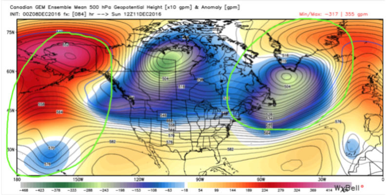
I first want to start out with a look at the broad picture. The image below is a look at last night's EURO Ensemble mean 500 hPa heights (black contours) and anomalies (color shadings; blues indicate anomalous roughing, reds indicate anomalous ridging), valid 12z Sunday.
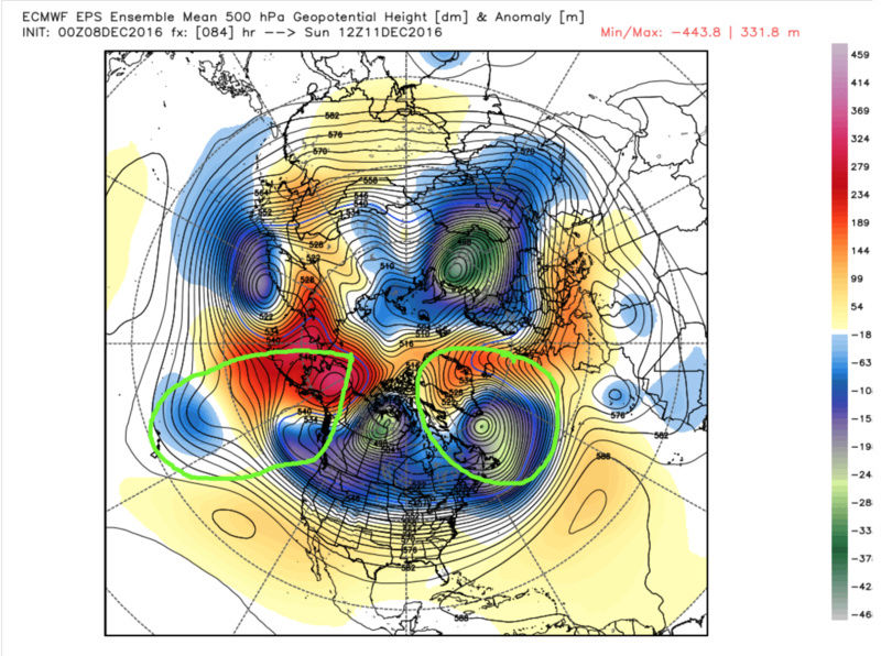
The regions of interest are highlighted in the green circles. Starting in the west (WPO/EPO domain), it's clear that we have a stout -WPO ridge across the north-central Pacific and into Alaska, with a shortwave trough near Hawaii that's attempting to bridge with the trough over the northeastern Pacific and northwestern North America. With this configuration, we also have a -EPO, although it is not the cleanest setup I have ever seen. Both of these indices with these phases support troughing and colder air in the eastern U.S. Looking quickly in the Arctic, notice that there is an approximate neutral state, as evidenced by the relatively equal spatial distributions of anomalous troughing and ridging. Moving into the east (NAO domain), you can see that there is a transient 50/50 (south-southwest of Greenland) low which is pumping a transient slightly negative to neutral NAO. The presence of the 50/50 low and associated NAO phase also supports a minor amount of troughing and cold air in the East.
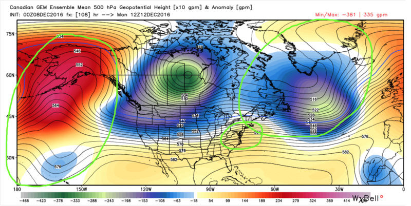
Now take a look at the same map but valid for 12z Monday:
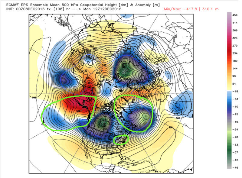
Notice how the EPO/WPO domain trended a bit stronger, as there are now more negative height anomalies bridging between the Hawaiian and North American troughs, but the NAO and 50/50 anomalies are now shifted northeast of where they were. With this configuration, we've lost the best properties of both components in the NAO domain. The 50/50 low is now too far northeast to promote the slightly negative to neutral NAO phase, and is now promoting a neutral to slightly positive phase. This means that we have lost one of the mechanisms for driving colder air into the East. Also, with the location of the 50/50 low, its wave spacing is far enough ahead of the main North American trough in the western part of the continent such that systems will be able to start sneaking behind it, as they will start to be more influenced by the main trough instead of being suppressed by the blocking attribute of the 50/50 low. Also notice how there is now a circle over the Mid-Atlantic signifying the height rises in this region, which is supported by the transience of the 50/50 low and favorable NAO state it forced. Lastly, the AO phase remains generally neutral to even slightly positive throughout this event, which also favors marginal cold in the East (at best).
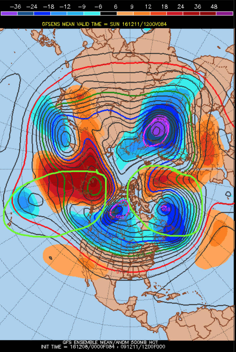
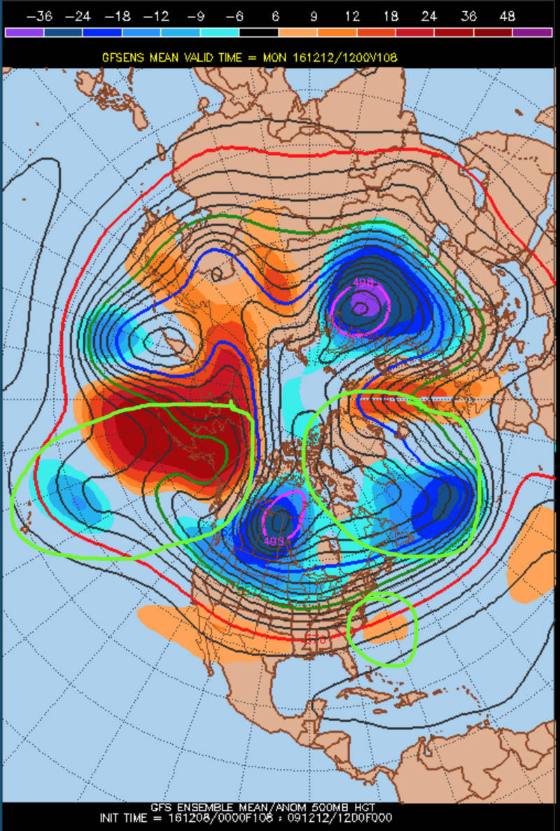
For comparison, here are the GFS Ensembles for the same time frames:
And the GEM ensembles:
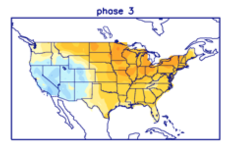
The higher height anomalies coming into the East as the event occurs are also supported, although admittedly weakly, by the possible emergence of the MJO into a weak phase 3 as suggested by the most recent guidance. An MJO pulse in phase 3 generally corresponds to the following temperature composites for November-January:
However, with the statistical significance:
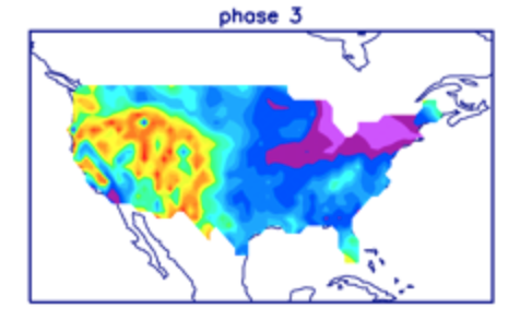
and the fact that if it does emerge it will be weak (<1 St. Dev.), I think it only argues for a very muted Mid-lattitude response; but a response nonetheless.
Based on these factors, I am actually thinking that we could see this system trend northward in coming runs, or at least a northward shift of the lower-level thermal gradients, as the sensible effects of the points I just outlined are realized in the models, assuming that what they are currently showing is correct.
Getting into more detail and discussing why I don't feel that this will be an event any larger than the one that we just saw yesterday, let's start with a map of precipitable water anomalies from last night's GFS Operational valid for Monday at 12z. The anomalies are depicted by the color shadings, where blues indicate drier than normal air and reds indicate higher than normal water content, and 700 hPa winds are denoted by the black wind barbs:

Notice how the boundary of weakly anomalous moisture essentially stops around the I-84 corridor, and the higher anomalies (above 1 St. Dev.) don't even make it much further north than the Mason-Dixon line. If you're looking for significant snow, that's a problem.
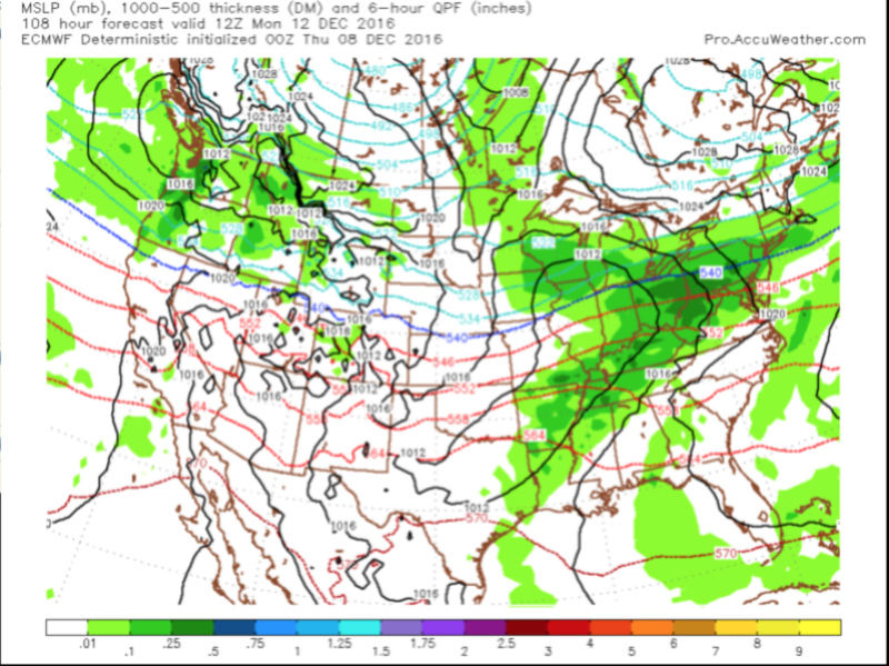
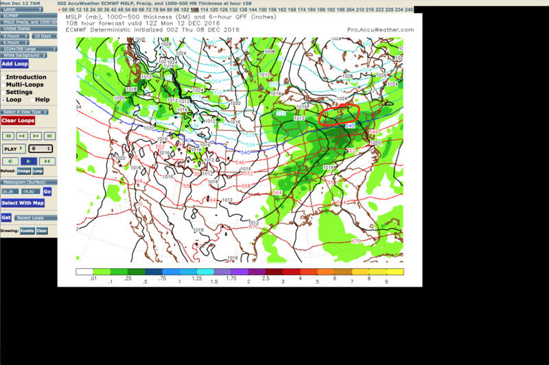
Working deeper in detail, here's a look at the EURO Operational surface 6-hourly QPF in the greens, pressures in the black contours, and 1000-500 hPa thicknesses in dashed color contours:
What follow will be temperature maps at 925, 850 and 700 hPa with contours every 2°C, where the purple line is the 0°C line, blue lines are below freezing and red lines above, heights in black contours, relative humidity in the green color fills, and winds in the black wind barbs:

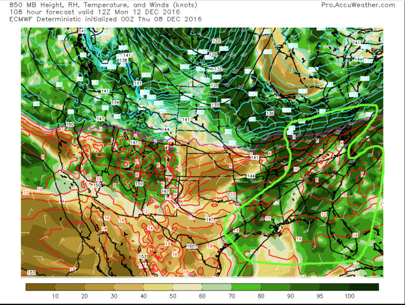
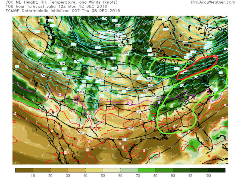
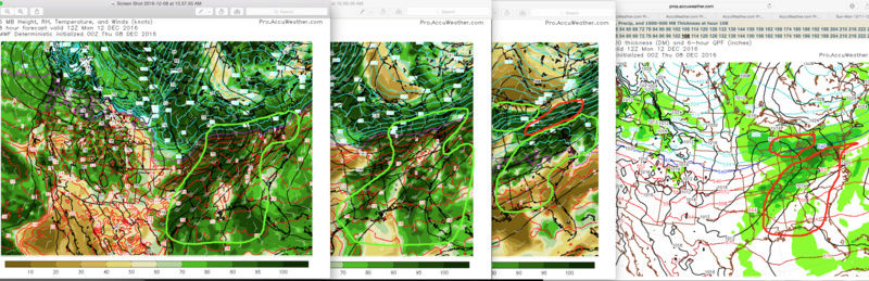
The green outlines show the region(s) of best temperature advection (isentropic/upglide forcing for ascent) at all levels, with areas of red showing meager advection (700 hPa). When you overlap these regions, you get something like this (outlined in red on the last image to the right):
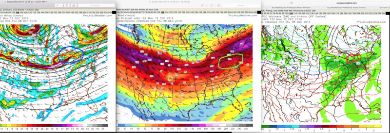
Looking at 500 hPa, where the heights are in the black contours, winds are denoted by the black wind barbs, the vorticity (energy) is depicted by the color fills, and the positive vorticity advection (forcing for ascent) is shown in the blue outline:

Lastly, looking at the 300 hPa jet structure, where the wind directions and speeds are shown by the black wind barbs, the speeds are more clearly shown by the color fills (in knots), and the region of best upper-level divergence forced by the jet (forcing for ascent) is outlined in green:
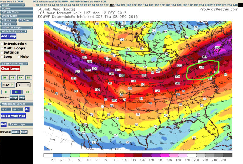
If we overlap the mid- and upper-level forcings for ascent, we get this (outlined in red on the last image to the right):
Finally, if we look at how all of the forcing mechanisms for ascent align, we get this (most overlap is outlined in red):
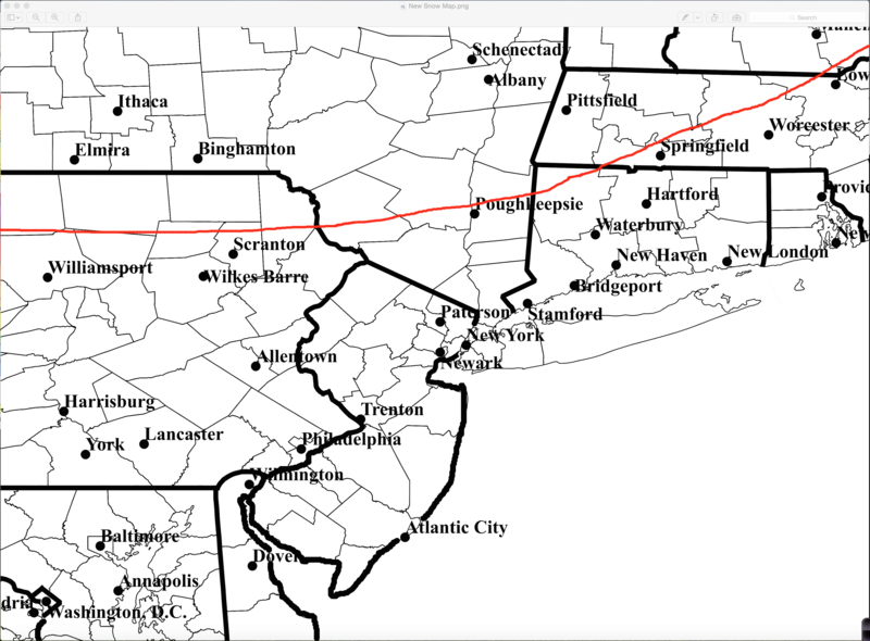
My argument is that even though the model is showing a wide swath of moderate precipitation, I feel that the steadiest, and heaviest, will end up in the region in red above. That's not to say that we will stay dry. I do think that there will be low-topped precipitation in the form of showers that are forced where the lower-level forcings align, but the best column-deep forcing for ascent is mainly across the body of New York State, which is where I think the highest threat of seeing accumulating snowfall will be. In terms of accumulations, I think a general 2-5" is a reasonable guess for the regions north of the red line seen below:
Not only is that the region of best column-deep forcing, but I am also expecting this system to trend northward in time, which will allow an increase in the meridional (north-south) advance of the lower-level warm advection (keeping areas to the south and towards the coast mainly wet), as well as a further northward extension of the weak moisture belt so it can overcome the lack of decent forcing at 700 hPa and realize the positive forcing above it. It would also not surprise me to see the energy itself trend stronger in the modeling once it crosses the Rockies, as such a setup argues for an enhancement of vortex tube stretching, and a strengthening of the spin of the energy once it crosses the mountains.
Hopefully this wasn't too long or confusing, but I figured this was better than waiting hours for a video to upload haha If you have any questions, comments, or concerns, let me know and I'll do my best!!
rb924119- Meteorologist
- Posts : 6889
Reputation : 194
Join date : 2013-02-06
Age : 32
Location : Greentown, Pa
Re: Sun-Mon 12/11-12/12 Discussions and Observations
![]() by SoulSingMG Thu Dec 08, 2016 12:11 pm
by SoulSingMG Thu Dec 08, 2016 12:11 pm
SoulSingMG- Senior Enthusiast
- Posts : 2853
Reputation : 74
Join date : 2013-12-11
Location : Long Island City, NY
Re: Sun-Mon 12/11-12/12 Discussions and Observations
![]() by algae888 Thu Dec 08, 2016 12:50 pm
by algae888 Thu Dec 08, 2016 12:50 pm

algae888- Advanced Forecaster

- Posts : 5311
Reputation : 46
Join date : 2013-02-05
Age : 61
Location : mt. vernon, new york
Re: Sun-Mon 12/11-12/12 Discussions and Observations
![]() by algae888 Thu Dec 08, 2016 12:57 pm
by algae888 Thu Dec 08, 2016 12:57 pm
algae888- Advanced Forecaster
- Posts : 5311
Reputation : 46
Join date : 2013-02-05
Age : 61
Location : mt. vernon, new york
Re: Sun-Mon 12/11-12/12 Discussions and Observations
![]() by sroc4 Thu Dec 08, 2016 1:25 pm
by sroc4 Thu Dec 08, 2016 1:25 pm
_________________
"In weather and in life, there's no winning and losing; there's only winning and learning."
WINTER 2012/2013 TOTALS 43.65"WINTER 2017/2018 TOTALS 62.85" WINTER 2022/2023 TOTALS 4.9"
WINTER 2013/2014 TOTALS 64.85"WINTER 2018/2019 TOTALS 14.25" WINTER 2023/2024 TOTALS 13.1"
WINTER 2014/2015 TOTALS 71.20"WINTER 2019/2020 TOTALS 6.35"
WINTER 2015/2016 TOTALS 35.00"WINTER 2020/2021 TOTALS 37.75"
WINTER 2016/2017 TOTALS 42.25"WINTER 2021/2022 TOTALS 31.65"
sroc4- Admin
- Posts : 8331
Reputation : 301
Join date : 2013-01-07
Location : Wading River, LI
Re: Sun-Mon 12/11-12/12 Discussions and Observations
![]() by SoulSingMG Thu Dec 08, 2016 4:02 pm
by SoulSingMG Thu Dec 08, 2016 4:02 pm
SoulSingMG- Senior Enthusiast
- Posts : 2853
Reputation : 74
Join date : 2013-12-11
Location : Long Island City, NY
Re: Sun-Mon 12/11-12/12 Discussions and Observations
![]() by Guest Thu Dec 08, 2016 4:18 pm
by Guest Thu Dec 08, 2016 4:18 pm
Guest- Guest
Re: Sun-Mon 12/11-12/12 Discussions and Observations
![]() by sroc4 Thu Dec 08, 2016 4:41 pm
by sroc4 Thu Dec 08, 2016 4:41 pm
Last edited by sroc4 on Thu Dec 08, 2016 4:58 pm; edited 1 time in total
_________________
"In weather and in life, there's no winning and losing; there's only winning and learning."
WINTER 2012/2013 TOTALS 43.65"WINTER 2017/2018 TOTALS 62.85" WINTER 2022/2023 TOTALS 4.9"
WINTER 2013/2014 TOTALS 64.85"WINTER 2018/2019 TOTALS 14.25" WINTER 2023/2024 TOTALS 13.1"
WINTER 2014/2015 TOTALS 71.20"WINTER 2019/2020 TOTALS 6.35"
WINTER 2015/2016 TOTALS 35.00"WINTER 2020/2021 TOTALS 37.75"
WINTER 2016/2017 TOTALS 42.25"WINTER 2021/2022 TOTALS 31.65"
sroc4- Admin
- Posts : 8331
Reputation : 301
Join date : 2013-01-07
Location : Wading River, LI
Re: Sun-Mon 12/11-12/12 Discussions and Observations
![]() by jake732 Thu Dec 08, 2016 4:43 pm
by jake732 Thu Dec 08, 2016 4:43 pm

jake732- Pro Enthusiast

- Posts : 449
Reputation : 0
Join date : 2016-01-03
Location : lakewood, nj -
Re: Sun-Mon 12/11-12/12 Discussions and Observations
![]() by amugs Thu Dec 08, 2016 5:08 pm
by amugs Thu Dec 08, 2016 5:08 pm
SoulSingMG wrote:I have no maps but am hearing the EPS are out of control snowy for most of us over the next 8 days!
OOOOFAAAA!!!!!!!!!!

_________________
Mugs
AKA:King: Snow Weenie
Self Proclaimed
WINTER 2014-15 : 55.12" +.02 for 6 coatings (avg. 35")
WINTER 2015-16 Total - 29.8" (Avg 35")
WINTER 2016-17 : 39.5" so far

amugs- Advanced Forecaster - Mod

- Posts : 15093
Reputation : 213
Join date : 2013-01-07
Age : 54
Location : Hillsdale,NJ
Re: Sun-Mon 12/11-12/12 Discussions and Observations
![]() by Guest Thu Dec 08, 2016 5:14 pm
by Guest Thu Dec 08, 2016 5:14 pm
sroc4 wrote:Its going to be close for us Syo. There is no doubt trends have been a slightly weaker system that initially develops over the Ohio preventing from any sigificant height rises out ahead. This is key. The frontal boundary looks like it "should" remain to our south. Some level of CAD is likely to happen as the HP to the N looks pretty darn good on modeling, but us surrounded by still pretty warm waters could be the Achilles. IMO trends have been favorable for LI esp N shore. North Shore vs South shore could be the difference.
well if you are right (and I agree) then at least you and I are both on the N shore.
Guest- Guest
Re: Sun-Mon 12/11-12/12 Discussions and Observations
![]() by amugs Thu Dec 08, 2016 5:24 pm
by amugs Thu Dec 08, 2016 5:24 pm
For Sunday-Monday night the models are coming into better agreement
that fast zonal flow will produce a weaker/flatter (more sheared)
system moving in from the Intermountain West starting Sunday
morning. The reduced amplification will result in weaker warm
advection ahead of the system, with the warm front now likely
staying S of Long Island through the event, with a secondary low
tracking to the S of Long Island along the front. Northern stream
ridging ahead of the system will support the forming of a high over
SE Canada which should server as a source for low level cold air by
Monday (NE- E flow over the region - typical of a cold air damming
pattern).
In terms of sensible weather, the aforementioned shortwave ridging
passing to the north Sunday should hold off anything other than very
light precipitation into Sunday afternoon - with snow across the
interior and rain elsewhere. The precipitation will become more
widespread and steady Sunday night and should chance to all snow
from N to S Sunday evening across the Tri-State. Snow continues into
Monday, with precipitation mixing with then changing to rain over
Long Island and at least Southern portions of NYC and maybe coastal
SW CT Monday morning and then to all rain Monday afternoon, except
for maybe far Northern portions of the CWA where a rain/snow mix
could linger. Precipitation should taper off from W to E Monday
night as the low exits to the southeast of Cape Cod mainly as Snow
N of Long Island Sound and Rain to the south.
_________________
Mugs
AKA:King: Snow Weenie
Self Proclaimed
WINTER 2014-15 : 55.12" +.02 for 6 coatings (avg. 35")
WINTER 2015-16 Total - 29.8" (Avg 35")
WINTER 2016-17 : 39.5" so far
amugs- Advanced Forecaster - Mod
- Posts : 15093
Reputation : 213
Join date : 2013-01-07
Age : 54
Location : Hillsdale,NJ
Re: Sun-Mon 12/11-12/12 Discussions and Observations
![]() by jmanley32 Thu Dec 08, 2016 7:23 pm
by jmanley32 Thu Dec 08, 2016 7:23 pm
yeah sorry sroc please move it. I should known better but when I realized a reply had been made.sroc4 wrote:jmanley32 wrote:The coast mat see no snow this year next 16 days gfs has cutters interior snow coastal rain. I'd rather it just be dry and cool temps but not freezing.
This is banter Jman
jmanley32- Senior Enthusiast
- Posts : 20513
Reputation : 108
Join date : 2013-12-12
Age : 42
Location : Yonkers, NY
Re: Sun-Mon 12/11-12/12 Discussions and Observations
![]() by amugs Thu Dec 08, 2016 7:35 pm
by amugs Thu Dec 08, 2016 7:35 pm
_________________
Mugs
AKA:King: Snow Weenie
Self Proclaimed
WINTER 2014-15 : 55.12" +.02 for 6 coatings (avg. 35")
WINTER 2015-16 Total - 29.8" (Avg 35")
WINTER 2016-17 : 39.5" so far
amugs- Advanced Forecaster - Mod
- Posts : 15093
Reputation : 213
Join date : 2013-01-07
Age : 54
Location : Hillsdale,NJ
Re: Sun-Mon 12/11-12/12 Discussions and Observations
![]() by frank 638 Thu Dec 08, 2016 7:48 pm
by frank 638 Thu Dec 08, 2016 7:48 pm
frank 638- Senior Enthusiast
- Posts : 2824
Reputation : 37
Join date : 2016-01-01
Age : 40
Location : bronx ny
Re: Sun-Mon 12/11-12/12 Discussions and Observations
![]() by Dunnzoo Thu Dec 08, 2016 8:01 pm
by Dunnzoo Thu Dec 08, 2016 8:01 pm
_________________
Janet
Snowfall winter of 2023-2024 17.5"
Snowfall winter of 2022-2023 6.0"
Snowfall winter of 2021-2022 17.6" 1" sleet 2/25/22
Snowfall winter of 2020-2021 51.1"
Snowfall winter of 2019-2020 8.5"
Snowfall winter of 2018-2019 25.1"
Snowfall winter of 2017-2018 51.9"
Snowfall winter of 2016-2017 45.6"
Snowfall winter of 2015-2016 29.5"
Snowfall winter of 2014-2015 50.55"
Snowfall winter of 2013-2014 66.5"

Dunnzoo- Senior Enthusiast - Mod
- Posts : 4886
Reputation : 68
Join date : 2013-01-11
Age : 62
Location : Westwood, NJ
Re: Sun-Mon 12/11-12/12 Discussions and Observations
![]() by skinsfan1177 Thu Dec 08, 2016 8:11 pm
by skinsfan1177 Thu Dec 08, 2016 8:11 pm

skinsfan1177- Senior Enthusiast
- Posts : 4485
Reputation : 35
Join date : 2013-01-07
Age : 46
Location : Point Pleasant Boro
Page 1 of 7 • 1, 2, 3, 4, 5, 6, 7 ![]()
|
|
|