
 Search
Long Range Thread 13.0
Page 6 of 40 •  1 ... 5, 6, 7 ... 23 ... 40
 ![]()
Re: Long Range Thread 13.0
![]() by jmanley32 Thu Dec 29, 2016 6:46 pm
by jmanley32 Thu Dec 29, 2016 6:46 pm
jmanley32- Senior Enthusiast

- Posts : 20516
Join date : 2013-12-12
Re: Long Range Thread 13.0
![]() by skinsfan1177 Thu Dec 29, 2016 6:53 pm
by skinsfan1177 Thu Dec 29, 2016 6:53 pm
skinsfan1177- Senior Enthusiast
- Posts : 4485
Join date : 2013-01-07
Re: Long Range Thread 13.0
![]() by frank 638 Thu Dec 29, 2016 7:00 pm
by frank 638 Thu Dec 29, 2016 7:00 pm
frank 638- Senior Enthusiast
- Posts : 2824
Reputation : 37
Join date : 2016-01-01
Age : 40
Location : bronx ny
Re: Long Range Thread 13.0
![]() by algae888 Thu Dec 29, 2016 8:10 pm
by algae888 Thu Dec 29, 2016 8:10 pm

algae888- Advanced Forecaster

- Posts : 5311
Reputation : 46
Join date : 2013-02-05
Age : 61
Location : mt. vernon, new york
Re: Long Range Thread 13.0
![]() by dsix85 Thu Dec 29, 2016 9:17 pm
by dsix85 Thu Dec 29, 2016 9:17 pm
dsix85- Pro Enthusiast

- Posts : 349
Reputation : 8
Join date : 2014-01-01
Location : New York

skinsfan1177- Senior Enthusiast
- Posts : 4485
Reputation : 35
Join date : 2013-01-07
Age : 46
Location : Point Pleasant Boro
Re: Long Range Thread 13.0
![]() by emokid51783 Thu Dec 29, 2016 9:27 pm
by emokid51783 Thu Dec 29, 2016 9:27 pm
emokid51783- Posts : 144
Reputation : 5
Join date : 2013-12-12
Age : 40
Location : Jersey City Heights, NJ
Re: Long Range Thread 13.0
![]() by Frank_Wx Thu Dec 29, 2016 9:27 pm
by Frank_Wx Thu Dec 29, 2016 9:27 pm
dsix85 wrote:When can the excitement become a legitimate chance of coming to fruition? The board has been quiet since the positive news broke early afternoon regarding the "potential" upcoming event.
Personally planning out my New Years. I would say the middle of next week is when the progged pattern change will pick up steam. Models are really excited about the January 6th-12th time frame still.
_________________
_______________________________________________________________________________________________________
CLICK HERE to view NJ Strong Snowstorm Classifications

Frank_Wx- Godzilla Seeker

- Posts : 21305
Reputation : 328
Join date : 2013-01-05
Age : 31
Location : Jersey City, NJ -

Re: Long Range Thread 13.0
![]() by dsix85 Thu Dec 29, 2016 9:30 pm
by dsix85 Thu Dec 29, 2016 9:30 pm
@Frank.. ah, to be young again. Enjoy your New Years. Really hoping the progged pattern does in fact pick up steam. That would make 2017 start off on the right foot.
dsix85- Pro Enthusiast
- Posts : 349
Reputation : 8
Join date : 2014-01-01
Location : New York
Re: Long Range Thread 13.0
![]() by Frank_Wx Thu Dec 29, 2016 9:34 pm
by Frank_Wx Thu Dec 29, 2016 9:34 pm
_________________
_______________________________________________________________________________________________________
CLICK HERE to view NJ Strong Snowstorm Classifications
Frank_Wx- Godzilla Seeker
- Posts : 21305
Reputation : 328
Join date : 2013-01-05
Age : 31
Location : Jersey City, NJ -
Re: Long Range Thread 13.0
![]() by dsix85 Thu Dec 29, 2016 9:35 pm
by dsix85 Thu Dec 29, 2016 9:35 pm
dsix85- Pro Enthusiast
- Posts : 349
Reputation : 8
Join date : 2014-01-01
Location : New York
Re: Long Range Thread 13.0
![]() by Math23x7 Thu Dec 29, 2016 9:44 pm
by Math23x7 Thu Dec 29, 2016 9:44 pm
Frank_Wx wrote:I have a video being made. Should be ready within 1 hour.
You asked Janet, Scott, and myself in a video message last February what the forum would think if you did video blogs? I relayed your message to this site while you were at your grandmother's house. It never got discussed beyond that because the headline was another possible significant snowstorm from the 18Z NAM that day.
Math23x7- Wx Statistician Guru

- Posts : 2379
Reputation : 68
Join date : 2013-01-08
Re: Long Range Thread 13.0
![]() by jmanley32 Thu Dec 29, 2016 9:53 pm
by jmanley32 Thu Dec 29, 2016 9:53 pm

jmanley32- Senior Enthusiast
- Posts : 20516
Reputation : 108
Join date : 2013-12-12
Age : 42
Location : Yonkers, NY
Re: Long Range Thread 13.0
![]() by emokid51783 Thu Dec 29, 2016 9:59 pm
by emokid51783 Thu Dec 29, 2016 9:59 pm
emokid51783- Posts : 144
Reputation : 5
Join date : 2013-12-12
Age : 40
Location : Jersey City Heights, NJ
Re: Long Range Thread 13.0
![]() by jmanley32 Thu Dec 29, 2016 10:09 pm
by jmanley32 Thu Dec 29, 2016 10:09 pm
Thats the great thing about the tread, you can go off there (appropriately) and its perfectly fine, thats why Frank made it cuz I think like a year or so ago things got so mucked up in threads that needed to stay on point. Lets all just stay hopeful, if theres anything I have learned over the years, there can be exciting years and very dull years, thats weather for you. Lets hope we get ST around the 7th, but if not do not lose it, look back at storms that happened that we never fathomed ie. Sandy (not saying I wished, or wish anything like that again but only mother nature knows what will actually happen and MAYBE SR models.dsix85 wrote:Great! Can't wait. Apologize for my rants; really belongs in the banter thread.
jmanley32- Senior Enthusiast
- Posts : 20516
Reputation : 108
Join date : 2013-12-12
Age : 42
Location : Yonkers, NY
Re: Long Range Thread 13.0
![]() by amugs Thu Dec 29, 2016 10:18 pm
by amugs Thu Dec 29, 2016 10:18 pm

_________________
Mugs
AKA:King: Snow Weenie
Self Proclaimed
WINTER 2014-15 : 55.12" +.02 for 6 coatings (avg. 35")
WINTER 2015-16 Total - 29.8" (Avg 35")
WINTER 2016-17 : 39.5" so far

amugs- Advanced Forecaster - Mod

- Posts : 15093
Reputation : 213
Join date : 2013-01-07
Age : 54
Location : Hillsdale,NJ
Re: Long Range Thread 13.0
![]() by amugs Thu Dec 29, 2016 10:30 pm
by amugs Thu Dec 29, 2016 10:30 pm
Next weekendish storm - this is a great set up
_________________
Mugs
AKA:King: Snow Weenie
Self Proclaimed
WINTER 2014-15 : 55.12" +.02 for 6 coatings (avg. 35")
WINTER 2015-16 Total - 29.8" (Avg 35")
WINTER 2016-17 : 39.5" so far
amugs- Advanced Forecaster - Mod
- Posts : 15093
Reputation : 213
Join date : 2013-01-07
Age : 54
Location : Hillsdale,NJ

Snow88- Senior Enthusiast
- Posts : 2193
Reputation : 4
Join date : 2013-01-09
Age : 35
Location : Brooklyn, NY
Re: Long Range Thread 13.0
![]() by jmanley32 Thu Dec 29, 2016 11:03 pm
by jmanley32 Thu Dec 29, 2016 11:03 pm
Wow super long range lol, jkSnow88 wrote:GFS has some snow for tomororw
Does this have any merit?
jmanley32- Senior Enthusiast
- Posts : 20516
Reputation : 108
Join date : 2013-12-12
Age : 42
Location : Yonkers, NY
Re: Long Range Thread 13.0
![]() by Frank_Wx Thu Dec 29, 2016 11:32 pm
by Frank_Wx Thu Dec 29, 2016 11:32 pm
_________________
_______________________________________________________________________________________________________
CLICK HERE to view NJ Strong Snowstorm Classifications
Frank_Wx- Godzilla Seeker
- Posts : 21305
Reputation : 328
Join date : 2013-01-05
Age : 31
Location : Jersey City, NJ -
Re: Long Range Thread 13.0
![]() by Armando Salvadore Thu Dec 29, 2016 11:50 pm
by Armando Salvadore Thu Dec 29, 2016 11:50 pm

Armando Salvadore- Advanced Forecaster
- Posts : 171
Reputation : 0
Join date : 2016-12-23
Location : Springfield, NJ
Re: Long Range Thread 13.0
![]() by Frank_Wx Thu Dec 29, 2016 11:59 pm
by Frank_Wx Thu Dec 29, 2016 11:59 pm

_________________
_______________________________________________________________________________________________________
CLICK HERE to view NJ Strong Snowstorm Classifications
Frank_Wx- Godzilla Seeker
- Posts : 21305
Reputation : 328
Join date : 2013-01-05
Age : 31
Location : Jersey City, NJ -
Re: Long Range Thread 13.0
![]() by Frank_Wx Fri Dec 30, 2016 7:10 am
by Frank_Wx Fri Dec 30, 2016 7:10 am

_________________
_______________________________________________________________________________________________________
CLICK HERE to view NJ Strong Snowstorm Classifications
Frank_Wx- Godzilla Seeker
- Posts : 21305
Reputation : 328
Join date : 2013-01-05
Age : 31
Location : Jersey City, NJ -
skinsfan1177- Senior Enthusiast
- Posts : 4485
Reputation : 35
Join date : 2013-01-07
Age : 46
Location : Point Pleasant Boro
Re: Long Range Thread 13.0
![]() by sroc4 Fri Dec 30, 2016 8:47 am
by sroc4 Fri Dec 30, 2016 8:47 am
The system that will cut to our west the middle of next week and give us well above normal temps, and more rain as Frank illustrated in his video will drag a cold front through the area later in the week. This will signal the beginning of the colder weather pattern being advertised for the time frame between the 5th-12th at least.
Now the 7th-9th specifically there is def a storm signal; simply meaning that some of the larger scale upper level features are modeled such that if the right ingredients are added at the right time a decent shot at a wide spread snow event for our area is possible. To reiterate its possible not definite.
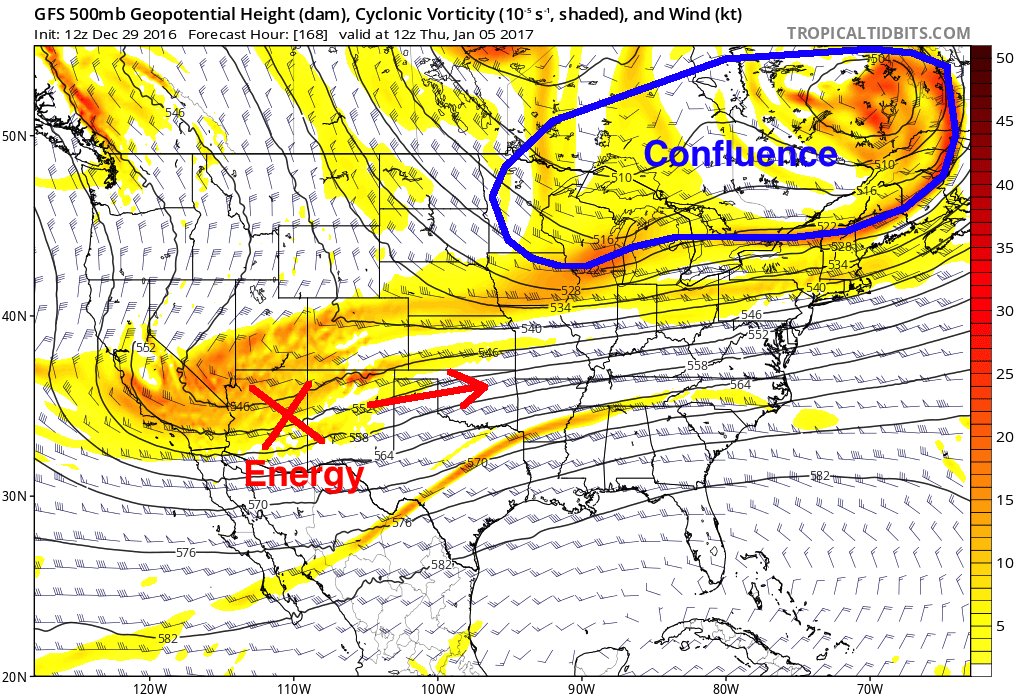
Here is the way the upper levels are currently set up and the reason why at he surface we do not see the system crushing us with Godzilla for now hopefully. Personally I NEVER want to see us locked into the bulls eye beyond 5-7days so for now we are right where we want to be; however, there are upper level features that need to trend differently in order for this to happen.
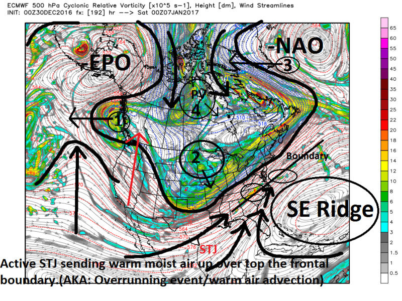
Lets use the 00z euro 500mb map, image valid 00z Sat Jan 7th, to show the key features the way they are set up now. After next weeks cutter pushes the cold front through a boundary layer will set up off the coast. Warm moisture laden air will ride up and over this leading to wide spread precip along this boundary with weak area of LP developing along it.
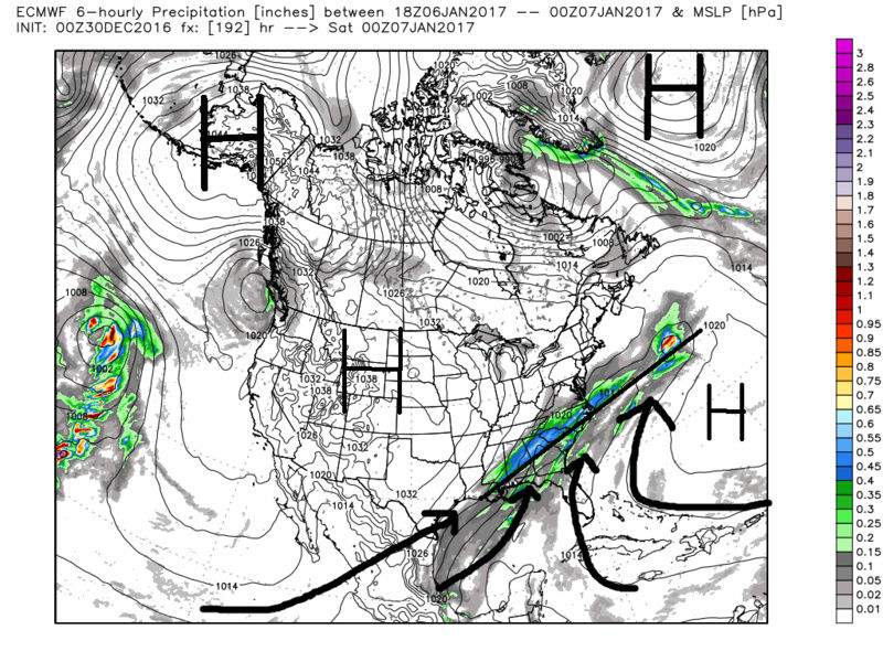
As of now there isn't a mechanism for the trough to dig into the boundary leading to strong cyclogenesis and a system that comes up the coast as a trough tilts neg. Instead the trough remains positive tilted as it exits the EC keeping the flow progressive, and the boundary remains to our south. It moves off shore and we are left with a close call. Again this is simply verbatim the way models show it now. GFS is even weaker with the main trough and even more progressive with the energy and precip...no surprise. But the upper level features are still looking good and we have plenty of time, but we still need a few things to happen.
1) If the area I labeled 1 on the map were a little slower to coming onshore in western Canada this might lead to a ridge axis along the western CONUS (red arrow) instead of a ridge axis that is out in the Pac (black arrow). This would help to drive the area labeled 2 into the trough.
2) The area I labeled 2 is a piece of Northern energy that as of now is modeled to be pretty weak. If the ridging along the west coast trends better as indicated above and or if this energy trends stronger and a tad faster then it might allow it to dig into and phase into the trough allowing for a neutral; then hopefully neg tilted trough as it reaches the EC. This would lead to a Godzilla potential.
3&4) The areas I labeled 3 and 4 kind of go hand in hand. If 4 were to trend a tad further S&E over the Hudson Bay it would leave room for 3, the NAO ridging to extend further west. This would aid in slowing up the upstream flow and hopefully allow the trough to dig and tilt neutral to neg. However if the NAO ridging trends stronger and further west, 3, then it would likely lead to 4 on the map further south. Same result for sifferent reasons...which came first the chicken or the egg. Who cares. Now in general If 4 is too far south and esp east it could lead to suppression as well.
Any or all of these things outlined could help our chances should theytrend the way described. That said I am sure there are other things that I did not outline that could also play a role for better or worse. For instance how strong the SE ridge is. In the current set up, however, I do not believe this time frame we see a cutter due to a stronger than forecasted SE Ridge. Its either a mild-mod snow event for our area due to a progressive positive tilted trough and WAA, or the boundary is too far south so its suppression depression, or the trough finds a way to dig and we get a true Godzilla potential.
Watch the trends and DO NOT be surprised if we don't see the true final soln until at least mid week next week because the cutter that will bring us the dreaded warm temps next week is forecasted to be a major player in setting up and aiding in the -NAO ridging. So how that system evolves ultimately will influence what happens after it moves into N latitudes.
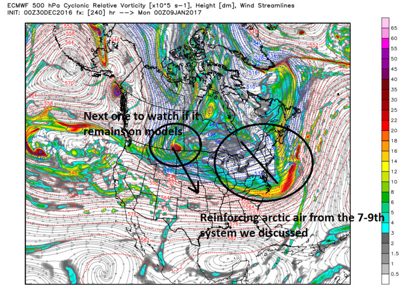
Verbatim at the end of the Euro run, hr 240, I love the look of the next N vort diving into the central plains. That will be the next thing to watch if it remains on modeling:
We Track!!!

_________________
"In weather and in life, there's no winning and losing; there's only winning and learning."
WINTER 2012/2013 TOTALS 43.65"WINTER 2017/2018 TOTALS 62.85" WINTER 2022/2023 TOTALS 4.9"
WINTER 2013/2014 TOTALS 64.85"WINTER 2018/2019 TOTALS 14.25" WINTER 2023/2024 TOTALS 13.1"
WINTER 2014/2015 TOTALS 71.20"WINTER 2019/2020 TOTALS 6.35"
WINTER 2015/2016 TOTALS 35.00"WINTER 2020/2021 TOTALS 37.75"
WINTER 2016/2017 TOTALS 42.25"WINTER 2021/2022 TOTALS 31.65"

sroc4- Admin
- Posts : 8331
Reputation : 301
Join date : 2013-01-07
Location : Wading River, LI
Re: Long Range Thread 13.0
![]() by Isotherm Fri Dec 30, 2016 10:06 am
by Isotherm Fri Dec 30, 2016 10:06 am
Scott, I also tend to agree with your prior stratospheric post regarding late January. I am now looking ahead for a true stratospheric alteration, and we will be evolving into an auspicious precursor pattern over the next week to 10 days for wave 2 convergence at the vortex. The guidance is not detecting a follow up wave 2 right now as it's only 10 day guidance, but I would expect wave 2 amplitude to significantly increase by Jan 20th +/- a few days. If it is sufficiently potent, this could set the stage for an interesting February as I alluded to in past weeks. Many are of the opinion that the upcoming neg NAO will have maintenance power, but I am not convinced yet due to other exogenous signals. We shall see. The negative trend to the NAO is probably real; the EPS has been persistent with this D10+ signal for a few days now, but again, exactly how it evolves is indeterminate.
After the first week of Jan blowtorch, I will say that the mid Jan return to warmth doesn't look as anomalous. This too will be influenced by height suppression via downstream blocking.
Last edited by Isotherm on Fri Dec 30, 2016 10:09 am; edited 1 time in total
Isotherm- Advanced Forecaster
- Posts : 231
Reputation : 4
Join date : 2014-09-01
Age : 33
Location : Monmouth County, NJ -
Re: Long Range Thread 13.0
![]() by jake732 Fri Dec 30, 2016 10:08 am
by jake732 Fri Dec 30, 2016 10:08 am

jake732- Pro Enthusiast
- Posts : 449
Reputation : 0
Join date : 2016-01-03
Location : lakewood, nj -
Page 6 of 40 • 1 ... 5, 6, 7 ... 23 ... 40 ![]()
|
|
|