
 Search
January 7th-8th Wave 2 Snow Event
Page 1 of 25 • 1, 2, 3 ... 13 ... 25 ![]()

January 7th-8th Wave 2 Snow Event
![]() by Frank_Wx Tue Jan 03, 2017 8:56 pm
by Frank_Wx Tue Jan 03, 2017 8:56 pm
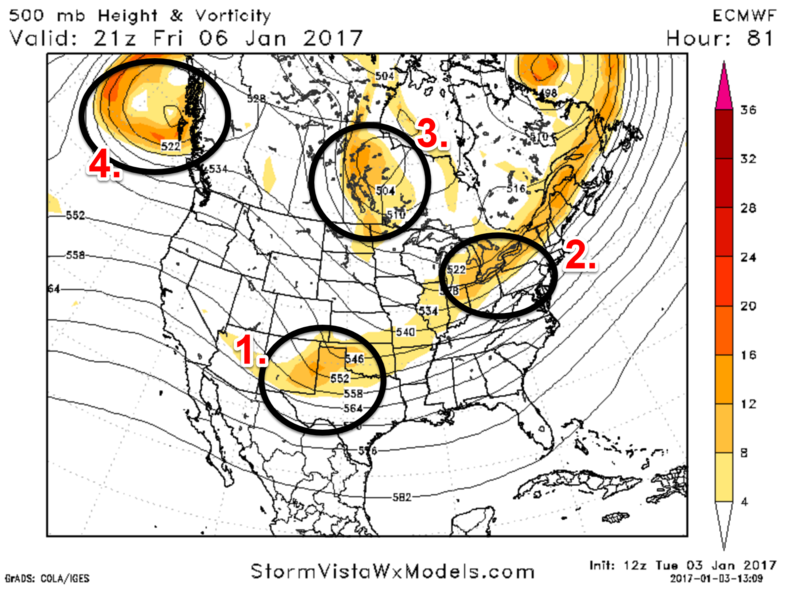
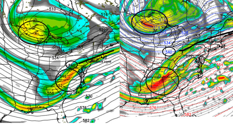
There are 4 key pieces of 500mb upper level energy that will dictate the evolution of this potential Godzilla. Circles labeled #3 and #4 are 500mb closed low's. You can tell they're closed because the height contours surrounding them are circular, aka closed off. In contrast, circles labeled #1 and #2 are broad open waves moving through the air flow. This is a 500mb vorticity graphic of the 12z EURO valid for 4:00pm Friday.
The elongated upper level energy at the front-side of the trough (#2) is the energy associated with whatever snow may fall from Wave 1 on Friday. There are dramatic differences with how the EURO and GFS models handle this H5 (500mb) energy. The EURO takes it almost due north-northeast, so it keeps heights along the east coast higher. The GFS takes this H5 energy east-northeast, which flattens heights enough to prevent amplification in the trough where H5 energies labeled #1 and #3 could phase. This is one reason why the EURO is more robust in showing a coastal storm near the coast late Saturday while GFS is well south and out to sea.
Upper level energy marked #1 is your southern stream energy. The one marked #3 is your closed 500mb low (northern energy). The all-out Godzilla storm will only come together if these two pieces of energies phase along the East Coast. There are roadblocks though that may prevent this from happening. I already talked about the first one, which is where upper level energy (#2) exactly tracks. Too far east and heights will be too de-amplified for a phase to happen. Luckily, the GFS has a progressive bias and tends to shoot upper level energies east so I am favoring the EURO in this regard. The second roadblock, but one I'm not fretting at this time, is the western U.S. ridge spike is not strong enough to dig the northern stream energy south and east toward the coast. Reason being the closed 500mb low (#4) off the SW Canadian coast is strong enough (remember circular wind flow since it's a closed 500mb and not open) to pump heights ahead of it. If for whatever reason heights stay flat out west there will be virtually no chance of a phase between #1 and #3 (southern and northern, respectively) energies.
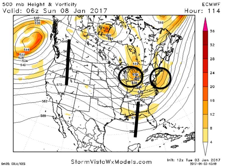
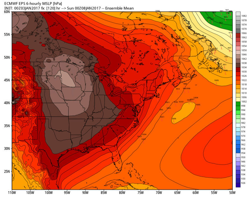
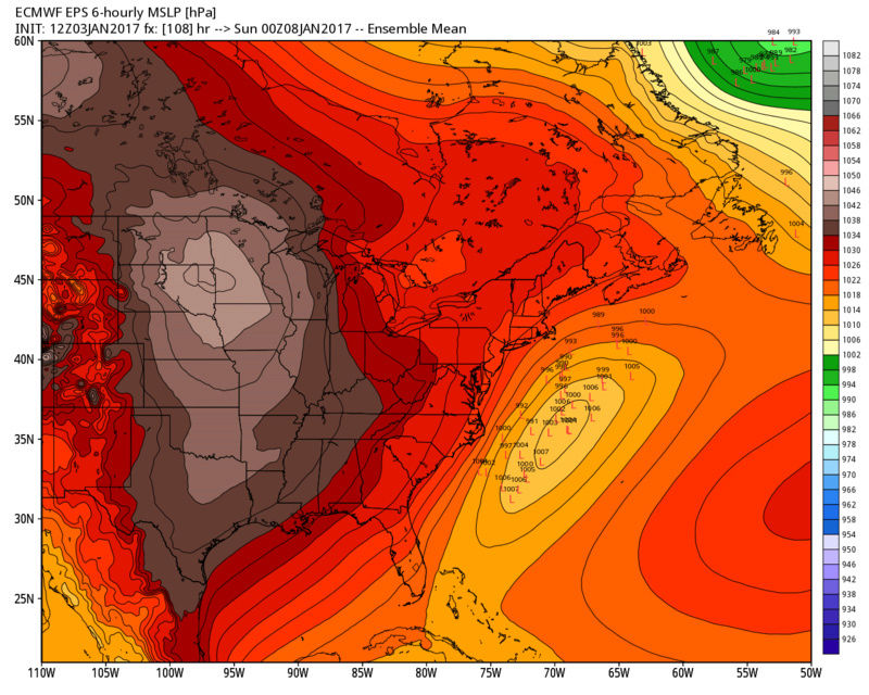
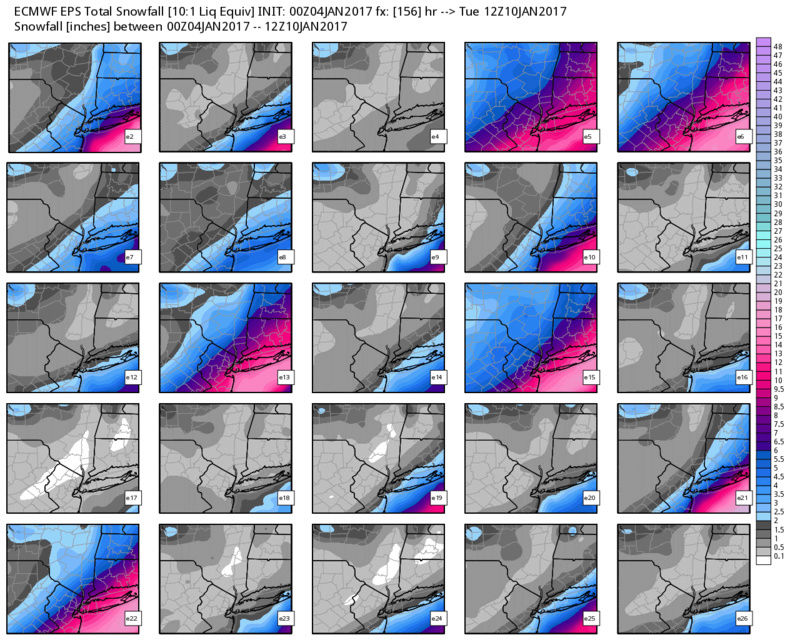
Sticking with the EURO, here is the 500mb picture 1am Sunday. The southern stream energy (#1 from map above) is the circle to the right of NJ. The northern stream energy from the map above (#3) is the circle over the Ohio Valley. Verbatim, the EURO does not show a phase. It just misses. But this model, as long as the UKMET, is VERY bullish in marrying these two H5 energies. In fact, the UKMET shows a significant winter storm bringing a swath of 10"+ snow amounts to the area. Here's what we need to see from the models in upcoming runs:
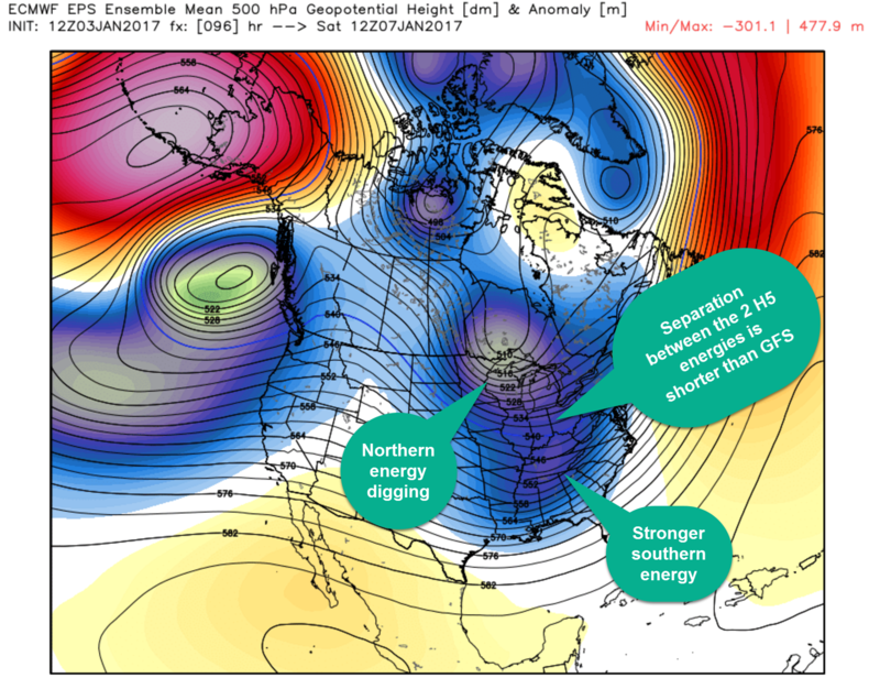
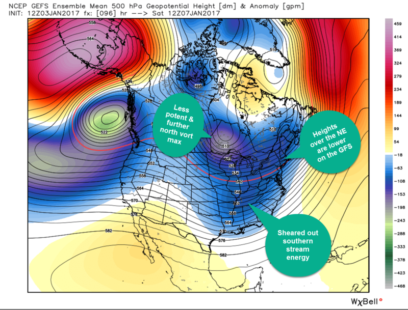
Top graph shows 500mb height anomalies of the 12z EPS (ECM Ensembles). Bottom graph is the same but for 12z GEFS (GFS Ensembles) valid for 7am Saturday. I labeled the major difference between the two. You can better notice the flatter heights over the Northeast on the GEFS opposed to the EPS, which show higher heights thanks to how upper level energy associated with Wave 1 is handled. The GFS is also weaker with the southern stream energy. One reason why I disagree with its depiction is because the Gulf of Mexico is open for business. A strong Sub-Tropical Jet stream is modeled in this time frame which would argue for the southern stream energy to be stronger than what the GFS shows. EURO, UKIE, even NAM show a much stronger vort.
It will be interesting to see if models phase the northern and southern stream energies in future runs. I wish we had a better -NAO to help slow the flow down. It was not long ago we were talking about a -NAO around this time period, but it's more of a ridge in the north Atlantic that's not acting as a block to buckle the jet. You see some height rise over the Davis Straight which could act to slow the flow down enough to make timing just right. Would be awesome to see this feature trend stronger, as long as the northern stream closed 500mb low stays closed off.

Another cool feature is the 250mb upper level jet streak the EURO shows over New England late Saturday. Strong diverging winds at the upper levels could help "bomb" this potential coastal storm out as long as there is a phase. Some may argue the southern stream energy could take a track further north or closer to the coast, increasing odds of a phase with the northern stream, because of this jet streak. I'm not sure I buy into that theory, but if you believe in trends then they're currently your friends.
We'll see where this takes us.
_________________
_______________________________________________________________________________________________________
CLICK HERE to view NJ Strong Snowstorm Classifications

Frank_Wx- Godzilla Seeker

- Posts : 21305
Reputation : 328
Join date : 2013-01-05
Age : 31
Location : Jersey City, NJ -

Re: January 7th-8th Wave 2 Snow Event
![]() by emokid51783 Tue Jan 03, 2017 9:15 pm
by emokid51783 Tue Jan 03, 2017 9:15 pm
emokid51783- Posts : 144
Reputation : 5
Join date : 2013-12-12
Age : 40
Location : Jersey City Heights, NJ
Re: January 7th-8th Wave 2 Snow Event
![]() by Armando Salvadore Tue Jan 03, 2017 9:20 pm
by Armando Salvadore Tue Jan 03, 2017 9:20 pm

Armando Salvadore- Advanced Forecaster

- Posts : 171
Reputation : 0
Join date : 2016-12-23
Location : Springfield, NJ
Re: January 7th-8th Wave 2 Snow Event
![]() by dsix85 Tue Jan 03, 2017 9:24 pm
by dsix85 Tue Jan 03, 2017 9:24 pm
@Frank- any shot at this potentially reaching Frankzilla status?
dsix85- Pro Enthusiast

- Posts : 349
Reputation : 8
Join date : 2014-01-01
Location : New York
Re: January 7th-8th Wave 2 Snow Event
![]() by Frank_Wx Tue Jan 03, 2017 9:25 pm
by Frank_Wx Tue Jan 03, 2017 9:25 pm
One day, we will get our Frankzilla.
_________________
_______________________________________________________________________________________________________
CLICK HERE to view NJ Strong Snowstorm Classifications
Frank_Wx- Godzilla Seeker
- Posts : 21305
Reputation : 328
Join date : 2013-01-05
Age : 31
Location : Jersey City, NJ -
Re: January 7th-8th Wave 2 Snow Event
![]() by billg315 Tue Jan 03, 2017 9:26 pm
by billg315 Tue Jan 03, 2017 9:26 pm
(Whatever "certainty" means in this business).

billg315- Advanced Forecaster - Mod

- Posts : 4462
Reputation : 185
Join date : 2015-01-24
Age : 50
Location : Flemington, NJ
Re: January 7th-8th Wave 2 Snow Event
![]() by dsix85 Tue Jan 03, 2017 9:27 pm
by dsix85 Tue Jan 03, 2017 9:27 pm
Also, what's your gut on duration and peak snowfall rates at the height of the storm? I know it's a lot of speculation but very interested in hearing your INITIAL thoughts for start/end time and peak rates.
dsix85- Pro Enthusiast
- Posts : 349
Reputation : 8
Join date : 2014-01-01
Location : New York
Re: January 7th-8th Wave 2 Snow Event
![]() by jmanley32 Tue Jan 03, 2017 9:28 pm
by jmanley32 Tue Jan 03, 2017 9:28 pm
don't jinx it! Be happy we may be looking at a godzilla which Frank in his initial outlook said may not happen at all. Also I think you mean roidzilla, A Frankzilla would be rediculous you went straight to the triple dog dare you loldsix85 wrote:My espresso will be ready for this! These are indeed exciting times; let's see what another day of modeling brings. As Frank so brilliantly pointed out, if our baby stays strong after the 12z runs on Thursday we can then rejoice. Until then, tread carefully and lets see another full day of runs to support this beast.
@Frank- any shot at this potentially reaching Frankzilla status?

jmanley32- Senior Enthusiast

- Posts : 20512
Reputation : 108
Join date : 2013-12-12
Age : 42
Location : Yonkers, NY
Re: January 7th-8th Wave 2 Snow Event
![]() by Frank_Wx Tue Jan 03, 2017 9:29 pm
by Frank_Wx Tue Jan 03, 2017 9:29 pm
emokid51783 wrote:I got my coffee and popcorn ready
If you ask politely, Janet may give you some Bailey's.
Armando Salvadore wrote:Wow, excellent write up Frank! Not much to even add to it, the GFS does indeed seem more bias given the entire H5 setup, and the Euro deems as a better model in situations and split flows such as these. Key factors are speed and timing of the southern and northern branch, plus depth. I see more support (as you've included) for a sharpening trough and tighter baroclinic zone than what the GFS/GEFS shows. We'll see where 0z and 12z takes us next (tonight and tomorrow), but i also want to see proper NA sampling to see what really happens from there on out.
Thanks man. Yes, the sampling is critical. I'm not confident in any one solution until Thursday morning.
billg315 wrote:Good write-up Frank. One thing I think is fair to say, and which may be frustrating, is that from past experience we won't really know what we're dealing with Saturday night until we see how Wave 1 behaves Friday. Therefore this could be one of those storms without a lot of lead time in terms of "certainty"
(Whatever "certainty" means in this business).
Somewhat true. I think we'll have an idea about what Wave 1 decides to do by tomorrow night. At least at the 500mb level. If models still diverge at that point then we seriously need to ditch models and consider this:

_________________
_______________________________________________________________________________________________________
CLICK HERE to view NJ Strong Snowstorm Classifications
Frank_Wx- Godzilla Seeker
- Posts : 21305
Reputation : 328
Join date : 2013-01-05
Age : 31
Location : Jersey City, NJ -
Re: January 7th-8th Wave 2 Snow Event
![]() by dsix85 Tue Jan 03, 2017 9:30 pm
by dsix85 Tue Jan 03, 2017 9:30 pm
dsix85- Pro Enthusiast
- Posts : 349
Reputation : 8
Join date : 2014-01-01
Location : New York
Re: January 7th-8th Wave 2 Snow Event
![]() by jmanley32 Tue Jan 03, 2017 9:36 pm
by jmanley32 Tue Jan 03, 2017 9:36 pm
Frank how did you know where I lived? Thats my front doorstep LOL (yeah granted its Jon and not JOHN but still funny.Frank_Wx wrote:emokid51783 wrote:I got my coffee and popcorn ready
If you ask politely, Janet may give you some Bailey's.Armando Salvadore wrote:Wow, excellent write up Frank! Not much to even add to it, the GFS does indeed seem more bias given the entire H5 setup, and the Euro deems as a better model in situations and split flows such as these. Key factors are speed and timing of the southern and northern branch, plus depth. I see more support (as you've included) for a sharpening trough and tighter baroclinic zone than what the GFS/GEFS shows. We'll see where 0z and 12z takes us next (tonight and tomorrow), but i also want to see proper NA sampling to see what really happens from there on out.
Thanks man. Yes, the sampling is critical. I'm not confident in any one solution until Thursday morning.billg315 wrote:Good write-up Frank. One thing I think is fair to say, and which may be frustrating, is that from past experience we won't really know what we're dealing with Saturday night until we see how Wave 1 behaves Friday. Therefore this could be one of those storms without a lot of lead time in terms of "certainty"
(Whatever "certainty" means in this business).
Somewhat true. I think we'll have an idea about what Wave 1 decides to do by tomorrow night. At least at the 500mb level. If models still diverge at that point then we seriously need to ditch models and consider this:
jmanley32- Senior Enthusiast
- Posts : 20512
Reputation : 108
Join date : 2013-12-12
Age : 42
Location : Yonkers, NY
Re: January 7th-8th Wave 2 Snow Event
![]() by Frank_Wx Tue Jan 03, 2017 10:59 pm
by Frank_Wx Tue Jan 03, 2017 10:59 pm
_________________
_______________________________________________________________________________________________________
CLICK HERE to view NJ Strong Snowstorm Classifications
Frank_Wx- Godzilla Seeker
- Posts : 21305
Reputation : 328
Join date : 2013-01-05
Age : 31
Location : Jersey City, NJ -
Re: January 7th-8th Wave 2 Snow Event
![]() by Frank_Wx Tue Jan 03, 2017 11:06 pm
by Frank_Wx Tue Jan 03, 2017 11:06 pm
_________________
_______________________________________________________________________________________________________
CLICK HERE to view NJ Strong Snowstorm Classifications
Frank_Wx- Godzilla Seeker
- Posts : 21305
Reputation : 328
Join date : 2013-01-05
Age : 31
Location : Jersey City, NJ -
Re: January 7th-8th Wave 2 Snow Event
![]() by Frank_Wx Tue Jan 03, 2017 11:13 pm
by Frank_Wx Tue Jan 03, 2017 11:13 pm

_________________
_______________________________________________________________________________________________________
CLICK HERE to view NJ Strong Snowstorm Classifications
Frank_Wx- Godzilla Seeker
- Posts : 21305
Reputation : 328
Join date : 2013-01-05
Age : 31
Location : Jersey City, NJ -
Re: January 7th-8th Wave 2 Snow Event
![]() by Snow88 Tue Jan 03, 2017 11:16 pm
by Snow88 Tue Jan 03, 2017 11:16 pm
CMC,Navy trended towards the GFS
Lets hope it's a blip

Snow88- Senior Enthusiast
- Posts : 2193
Reputation : 4
Join date : 2013-01-09
Age : 35
Location : Brooklyn, NY
Re: January 7th-8th Wave 2 Snow Event
![]() by SoulSingMG Tue Jan 03, 2017 11:28 pm
by SoulSingMG Tue Jan 03, 2017 11:28 pm
Frank_Wx wrote:The Pacific 500mb energy (#1 in my first post) is still very weak on the GFS. The latest Canadian also shows a strung out Pacific vort. So that's a bad trend tonight. I won't be staying up for further model runs. Will update in the morning.
Well that's depressing considering Wednesday/tonight was suppose to be "the night" when we could start trusting the models more. I'll be up for the EURO and saying snow prayers until her run.

SoulSingMG- Senior Enthusiast
- Posts : 2853
Reputation : 74
Join date : 2013-12-11
Location : Long Island City, NY
Re: January 7th-8th Wave 2 Snow Event
![]() by jmanley32 Tue Jan 03, 2017 11:45 pm
by jmanley32 Tue Jan 03, 2017 11:45 pm
SoulSingMG wrote:Frank_Wx wrote:The Pacific 500mb energy (#1 in my first post) is still very weak on the GFS. The latest Canadian also shows a strung out Pacific vort. So that's a bad trend tonight. I won't be staying up for further model runs. Will update in the morning.
Well that's depressing considering Wednesday/tonight was suppose to be "the night" when we could start trusting the models more. I'll be up for the EURO and saying snow prayers until her run.
Sure is (yet its not Wednesday yet), im trying to stay optimistic but I am just not sure right now.
jmanley32- Senior Enthusiast
- Posts : 20512
Reputation : 108
Join date : 2013-12-12
Age : 42
Location : Yonkers, NY
Re: January 7th-8th Wave 2 Snow Event
![]() by SoulSingMG Wed Jan 04, 2017 1:28 am
by SoulSingMG Wed Jan 04, 2017 1:28 am
SoulSingMG- Senior Enthusiast
- Posts : 2853
Reputation : 74
Join date : 2013-12-11
Location : Long Island City, NY
Re: January 7th-8th Wave 2 Snow Event
![]() by skinsfan1177 Wed Jan 04, 2017 5:16 am
by skinsfan1177 Wed Jan 04, 2017 5:16 am

skinsfan1177- Senior Enthusiast
- Posts : 4485
Reputation : 35
Join date : 2013-01-07
Age : 46
Location : Point Pleasant Boro
Re: January 7th-8th Wave 2 Snow Event
![]() by algae888 Wed Jan 04, 2017 5:26 am
by algae888 Wed Jan 04, 2017 5:26 am
yes euro on its own right now with advisory level snows along the coast.SoulSingMG wrote:00z Euro continues to look better aloft than its previous runs. A glimmer of hope in an overall crap 00z suite.


algae888- Advanced Forecaster
- Posts : 5311
Reputation : 46
Join date : 2013-02-05
Age : 61
Location : mt. vernon, new york
Re: January 7th-8th Wave 2 Snow Event
![]() by Frank_Wx Wed Jan 04, 2017 5:48 am
by Frank_Wx Wed Jan 04, 2017 5:48 am

_________________
_______________________________________________________________________________________________________
CLICK HERE to view NJ Strong Snowstorm Classifications
Frank_Wx- Godzilla Seeker
- Posts : 21305
Reputation : 328
Join date : 2013-01-05
Age : 31
Location : Jersey City, NJ -
skinsfan1177- Senior Enthusiast
- Posts : 4485
Reputation : 35
Join date : 2013-01-07
Age : 46
Location : Point Pleasant Boro
Re: January 7th-8th Wave 2 Snow Event
![]() by sroc4 Wed Jan 04, 2017 6:19 am
by sroc4 Wed Jan 04, 2017 6:19 am
1) The S energy on the Euro is even stronger and more consolidated in the base of the trough when compared to yest 12z
2) The S energy on the GFS in the base of the trough has trended stronger overnight as well...which is good.
3) The S energy on the GFS; however, is further east then the Euro at this time frame. (A known progressive bias for the model).
4) I have highlighted the 540line with a black line on both models. Notice the GFS has it running through the lower HV; whereas, the euro has it way up in mid NY state.
5) If you watched Bernie Rayno's video last night he noted the importance of the energy to the N circled. Its this energy that in essence is what either allows room for it to come up or pushes it offshore. He noted it needs to trend a little slower and remain behind the S energy in order to allow the heights to raise out in front of the system allowing it to come up. As you can see both models have the S energy out in front of the N energy. Important point. However, notice the GFS has stray vorticity pressing down into the E GL relative to the Euro. It remains stronger and more consolidated within the circled area.
The area just S of this 540 line I highlighted is the area of confluence (area where the wind fields from the N and S branches converge at 500mb) As you are prob aware convergence of air aloft leads to air sinking; therefore, the precip shield will not make it beyond the confluent zone. The further N&W it is, the further N&W the precip shield can make it.
So the question is which model do you believe? For me with a known progressive bias of the GFS with S branch energy I have to believe over the next 3-4 runs we will see the energy in the S branch cont top consolidate like the euro shows; consequently the height field and confluent zone "should" lift N&W out ahead of the system more like the euro on consequent GFS runs. However; this is not a lock. The question is which is handling all these s/w better? The EPS means and trends supports the Euro Op, but the GEFS mean supports the GFS Op. We shall see. I will show the EPS updates in a different box.
_________________
"In weather and in life, there's no winning and losing; there's only winning and learning."
WINTER 2012/2013 TOTALS 43.65"WINTER 2017/2018 TOTALS 62.85" WINTER 2022/2023 TOTALS 4.9"
WINTER 2013/2014 TOTALS 64.85"WINTER 2018/2019 TOTALS 14.25" WINTER 2023/2024 TOTALS 13.1"
WINTER 2014/2015 TOTALS 71.20"WINTER 2019/2020 TOTALS 6.35"
WINTER 2015/2016 TOTALS 35.00"WINTER 2020/2021 TOTALS 37.75"
WINTER 2016/2017 TOTALS 42.25"WINTER 2021/2022 TOTALS 31.65"

sroc4- Admin
- Posts : 8331
Reputation : 301
Join date : 2013-01-07
Location : Wading River, LI
Re: January 7th-8th Wave 2 Snow Event
![]() by sroc4 Wed Jan 04, 2017 6:27 am
by sroc4 Wed Jan 04, 2017 6:27 am

_________________
"In weather and in life, there's no winning and losing; there's only winning and learning."
WINTER 2012/2013 TOTALS 43.65"WINTER 2017/2018 TOTALS 62.85" WINTER 2022/2023 TOTALS 4.9"
WINTER 2013/2014 TOTALS 64.85"WINTER 2018/2019 TOTALS 14.25" WINTER 2023/2024 TOTALS 13.1"
WINTER 2014/2015 TOTALS 71.20"WINTER 2019/2020 TOTALS 6.35"
WINTER 2015/2016 TOTALS 35.00"WINTER 2020/2021 TOTALS 37.75"
WINTER 2016/2017 TOTALS 42.25"WINTER 2021/2022 TOTALS 31.65"
sroc4- Admin
- Posts : 8331
Reputation : 301
Join date : 2013-01-07
Location : Wading River, LI
Re: January 7th-8th Wave 2 Snow Event
![]() by Frank_Wx Wed Jan 04, 2017 7:48 am
by Frank_Wx Wed Jan 04, 2017 7:48 am
skinsfan1177 wrote:Navy brings the goods
This is big. Usually a progressive model. Maybe 12z models today start trending to the EURO.

_________________
_______________________________________________________________________________________________________
CLICK HERE to view NJ Strong Snowstorm Classifications
Frank_Wx- Godzilla Seeker
- Posts : 21305
Reputation : 328
Join date : 2013-01-05
Age : 31
Location : Jersey City, NJ -
Page 1 of 25 • 1, 2, 3 ... 13 ... 25 ![]()
|
|
|