
 Search
January 22nd-24th Nor'easter Observations & Discussions
Page 8 of 43 •  1 ... 5 ... 7, 8, 9 ... 25 ... 43
 ![]()
Re: January 22nd-24th Nor'easter Observations & Discussions
![]() by jmanley32 Sun Jan 22, 2017 12:16 am
by jmanley32 Sun Jan 22, 2017 12:16 am
jmanley32- Senior Enthusiast

- Posts : 20516
Join date : 2013-12-12
Re: January 22nd-24th Nor'easter Observations & Discussions
![]() by Frank_Wx Sun Jan 22, 2017 12:29 am
by Frank_Wx Sun Jan 22, 2017 12:29 am
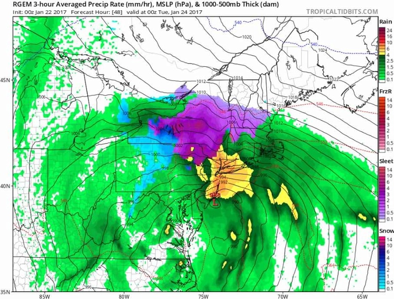
00z RGEM
Frank_Wx- Godzilla Seeker

- Posts : 21305
Join date : 2013-01-05 -

Re: January 22nd-24th Nor'easter Observations & Discussions
![]() by jmanley32 Sun Jan 22, 2017 12:31 am
by jmanley32 Sun Jan 22, 2017 12:31 am
Late to the party was posted back few pages, pretty intense huh? how was the wedding?Frank_Wx wrote:
00z RGEM

jmanley32- Senior Enthusiast
- Posts : 20516
Reputation : 108
Join date : 2013-12-12
Age : 42
Location : Yonkers, NY
Re: January 22nd-24th Nor'easter Observations & Discussions
![]() by Frank_Wx Sun Jan 22, 2017 12:31 am
by Frank_Wx Sun Jan 22, 2017 12:31 am

_________________
_______________________________________________________________________________________________________
CLICK HERE to view NJ Strong Snowstorm Classifications

Frank_Wx- Godzilla Seeker
- Posts : 21305
Reputation : 328
Join date : 2013-01-05
Age : 31
Location : Jersey City, NJ -
Re: January 22nd-24th Nor'easter Observations & Discussions
![]() by Frank_Wx Sun Jan 22, 2017 12:32 am
by Frank_Wx Sun Jan 22, 2017 12:32 am
jmanley32 wrote:Late to the party was posted back few pages, pretty intense huh? how was the wedding?Frank_Wx wrote:
00z RGEM
Long...good time though. Trying to catch up..
_________________
_______________________________________________________________________________________________________
CLICK HERE to view NJ Strong Snowstorm Classifications
Frank_Wx- Godzilla Seeker
- Posts : 21305
Reputation : 328
Join date : 2013-01-05
Age : 31
Location : Jersey City, NJ -
Re: January 22nd-24th Nor'easter Observations & Discussions
![]() by Frank_Wx Sun Jan 22, 2017 12:34 am
by Frank_Wx Sun Jan 22, 2017 12:34 am

_________________
_______________________________________________________________________________________________________
CLICK HERE to view NJ Strong Snowstorm Classifications
Frank_Wx- Godzilla Seeker
- Posts : 21305
Reputation : 328
Join date : 2013-01-05
Age : 31
Location : Jersey City, NJ -
Re: January 22nd-24th Nor'easter Observations & Discussions
![]() by jmanley32 Sun Jan 22, 2017 12:35 am
by jmanley32 Sun Jan 22, 2017 12:35 am
Ya you probably not gonna like a page back, its been taken care of by janet (thanks). Do you still hold to your scroll with the current models (wind levels etc, seems frozen chances may have gone up?)? Take your time in looking at things not expecting a immediate response.Frank_Wx wrote:jmanley32 wrote:Late to the party was posted back few pages, pretty intense huh? how was the wedding?Frank_Wx wrote:
00z RGEM
Long...good time though. Trying to catch up..
jmanley32- Senior Enthusiast
- Posts : 20516
Reputation : 108
Join date : 2013-12-12
Age : 42
Location : Yonkers, NY
Re: January 22nd-24th Nor'easter Observations & Discussions
![]() by jmanley32 Sun Jan 22, 2017 12:36 am
by jmanley32 Sun Jan 22, 2017 12:36 am
no inversion problems there that precip is intense and probably going to be when the highest winds will be yes? thats 4pm right? gonna be a real rough commute home, a nightmare.Frank_Wx wrote:
jmanley32- Senior Enthusiast
- Posts : 20516
Reputation : 108
Join date : 2013-12-12
Age : 42
Location : Yonkers, NY
Re: January 22nd-24th Nor'easter Observations & Discussions
![]() by rb924119 Sun Jan 22, 2017 12:43 am
by rb924119 Sun Jan 22, 2017 12:43 am
jmanley32 wrote:no inversion problems there that precip is intense and probably going to be when the highest winds will be yes?Frank_Wx wrote:
Careful, there probably still would be above the 900-850 hPa level. An inversion isn't only based upon the precipitation and whether or not it will bring the winds with it. An inversion only describes the thermal profile of the atmosphere. So, you can have heavy precipitation falling, but if there is a steep inversion, like is being modeled, the winds above the inversion WILL NOT mix down because that part of the atmospheric column is stable (that's what an inversion is; cold and dense air located beneath warmer and less dense air). Because the cold air is already on the bottom and the warm air above it, the atmosphere has no need or "want" to mix it. Now, if we had an isothermal profile, or purely moist adiabatic profile, where temperatures were either steady with increasing height or gradually decreasing THEN we'd have all kinds of wind issues. Does that maybe explain it a little better? Make a little more sense?
rb924119- Meteorologist

- Posts : 6890
Reputation : 194
Join date : 2013-02-06
Age : 32
Location : Greentown, Pa
Re: January 22nd-24th Nor'easter Observations & Discussions
![]() by jmanley32 Sun Jan 22, 2017 12:48 am
by jmanley32 Sun Jan 22, 2017 12:48 am
LOL, not totally but i get general jist, so the 925mb winds will still mix down though likely? Or a portion of them that is, thats what we have been talking about in terms of the winds I am guessing, the 925mb level, are the 850s too high up to mix? I wasn't thinking 700hpa winds would mix down, is that even possible? Imagine 250 lolrb924119 wrote:jmanley32 wrote:no inversion problems there that precip is intense and probably going to be when the highest winds will be yes?Frank_Wx wrote:
Careful, there probably still would be above the 900-850 hPa level. An inversion isn't only based upon the precipitation and whether or not it will bring the winds with it. An inversion only describes the thermal profile of the atmosphere. So, you can have heavy precipitation falling, but if there is a steep inversion, like is being modeled, the winds above the inversion WILL NOT mix down because that part of the atmospheric column is stable (that's what an inversion is; cold and dense air located beneath warmer and less dense air). Because the cold air is already on the bottom and the warm air above it, the atmosphere has no need or "want" to mix it. Now, if we had an isothermal profile, or purely moist adiabatic profile, where temperatures were either steady with increasing height or gradually decreasing THEN we'd have all kinds of wind issues. Does that maybe explain it a little better? Make a little more sense?
jmanley32- Senior Enthusiast
- Posts : 20516
Reputation : 108
Join date : 2013-12-12
Age : 42
Location : Yonkers, NY
Re: January 22nd-24th Nor'easter Observations & Discussions
![]() by jmanley32 Sun Jan 22, 2017 12:54 am
by jmanley32 Sun Jan 22, 2017 12:54 am
jmanley32- Senior Enthusiast
- Posts : 20516
Reputation : 108
Join date : 2013-12-12
Age : 42
Location : Yonkers, NY
Re: January 22nd-24th Nor'easter Observations & Discussions
![]() by rb924119 Sun Jan 22, 2017 1:01 am
by rb924119 Sun Jan 22, 2017 1:01 am
jmanley32 wrote:LOL, not totally but i get general jist, so the 925mb winds will still mix down though likely? Or a portion of them that is, thats what we have been talking about in terms of the winds I am guessing, the 925mb level, are the 850s too high up to mix? I wasn't thinking 700hpa winds would mix down, is that even possible? Imagine 250 lolrb924119 wrote:jmanley32 wrote:no inversion problems there that precip is intense and probably going to be when the highest winds will be yes?Frank_Wx wrote:
Careful, there probably still would be above the 900-850 hPa level. An inversion isn't only based upon the precipitation and whether or not it will bring the winds with it. An inversion only describes the thermal profile of the atmosphere. So, you can have heavy precipitation falling, but if there is a steep inversion, like is being modeled, the winds above the inversion WILL NOT mix down because that part of the atmospheric column is stable (that's what an inversion is; cold and dense air located beneath warmer and less dense air). Because the cold air is already on the bottom and the warm air above it, the atmosphere has no need or "want" to mix it. Now, if we had an isothermal profile, or purely moist adiabatic profile, where temperatures were either steady with increasing height or gradually decreasing THEN we'd have all kinds of wind issues. Does that maybe explain it a little better? Make a little more sense?
You're so difficult lmfao jk jk ahaha yes. Here's how I would look at it: whatever you see at 925 hPa, those speeds are likely representative of the gusts that will be observed. So if you see 60 knots at 925, you can be fairly confident that 60 knot gusts will be the max gusts at the surface, give or take a few because of momentum transfer. For sustained winds, due to turbulent eddies and fluxes associated with things like precipitation and friction, a rough approximation would be to use about 50-60% of what you see at 925. Remember, sustained speeds are calculated as two-minute averages, not instantaneous values, which is also why the ratio is so low versus the gusts. In this scenario, because of the inversion (at least off that image posted earlier), 850s would be too high to mix, yes. Lastly, it is very possible to get winds at 700 hPa to mix down to the surface, even as high as 500 hPa can largely get mixed down giveknthe rigut conditions. Where do you think your winds in severe thunderstorms and micro-bursts come from?
rb924119- Meteorologist
- Posts : 6890
Reputation : 194
Join date : 2013-02-06
Age : 32
Location : Greentown, Pa
Re: January 22nd-24th Nor'easter Observations & Discussions
![]() by jmanley32 Sun Jan 22, 2017 1:04 am
by jmanley32 Sun Jan 22, 2017 1:04 am
jmanley32- Senior Enthusiast
- Posts : 20516
Reputation : 108
Join date : 2013-12-12
Age : 42
Location : Yonkers, NY
Re: January 22nd-24th Nor'easter Observations & Discussions
![]() by jmanley32 Sun Jan 22, 2017 1:07 am
by jmanley32 Sun Jan 22, 2017 1:07 am
Gotcha, kinda difficult them cuz like RGEM doesnt have a gust map, and the surface map for some reason CMC maps do not bring the winds onshore even though they look like they should be, but dayumm euro.rb924119 wrote:jmanley32 wrote:LOL, not totally but i get general jist, so the 925mb winds will still mix down though likely? Or a portion of them that is, thats what we have been talking about in terms of the winds I am guessing, the 925mb level, are the 850s too high up to mix? I wasn't thinking 700hpa winds would mix down, is that even possible? Imagine 250 lolrb924119 wrote:jmanley32 wrote:no inversion problems there that precip is intense and probably going to be when the highest winds will be yes?Frank_Wx wrote:
Careful, there probably still would be above the 900-850 hPa level. An inversion isn't only based upon the precipitation and whether or not it will bring the winds with it. An inversion only describes the thermal profile of the atmosphere. So, you can have heavy precipitation falling, but if there is a steep inversion, like is being modeled, the winds above the inversion WILL NOT mix down because that part of the atmospheric column is stable (that's what an inversion is; cold and dense air located beneath warmer and less dense air). Because the cold air is already on the bottom and the warm air above it, the atmosphere has no need or "want" to mix it. Now, if we had an isothermal profile, or purely moist adiabatic profile, where temperatures were either steady with increasing height or gradually decreasing THEN we'd have all kinds of wind issues. Does that maybe explain it a little better? Make a little more sense?
You're so difficult lmfao jk jk ahaha yes. Here's how I would look at it: whatever you see at 925 hPa, those speeds are likely representative of the gusts that will be observed. So if you see 60 knots at 925, you can be fairly confident that 60 knot gusts will be the max gusts at the surface, give or take a few because of momentum transfer. For sustained winds, due to turbulent eddies and fluxes associated with things like precipitation and friction, a rough approximation would be to use about 50-60% of what you see at 925. Remember, sustained speeds are calculated as two-minute averages, not instantaneous values, which is also why the ratio is so low versus the gusts. In this scenario, because of the inversion (at least off that image posted earlier), 850s would be too high to mix, yes. Lastly, it is very possible to get winds at 700 hPa to mix down to the surface, even as high as 500 hPa can largely get mixed down giveknthe rigut conditions. Where do you think your winds in severe thunderstorms and micro-bursts come from?
jmanley32- Senior Enthusiast
- Posts : 20516
Reputation : 108
Join date : 2013-12-12
Age : 42
Location : Yonkers, NY
Re: January 22nd-24th Nor'easter Observations & Discussions
![]() by jmanley32 Sun Jan 22, 2017 1:09 am
by jmanley32 Sun Jan 22, 2017 1:09 am

Last edited by jmanley32 on Sun Jan 22, 2017 1:12 am; edited 1 time in total
jmanley32- Senior Enthusiast
- Posts : 20516
Reputation : 108
Join date : 2013-12-12
Age : 42
Location : Yonkers, NY
Re: January 22nd-24th Nor'easter Observations & Discussions
![]() by jmanley32 Sun Jan 22, 2017 1:10 am
by jmanley32 Sun Jan 22, 2017 1:10 am
jmanley32- Senior Enthusiast
- Posts : 20516
Reputation : 108
Join date : 2013-12-12
Age : 42
Location : Yonkers, NY
Re: January 22nd-24th Nor'easter Observations & Discussions
![]() by rb924119 Sun Jan 22, 2017 1:12 am
by rb924119 Sun Jan 22, 2017 1:12 am
rb924119- Meteorologist
- Posts : 6890
Reputation : 194
Join date : 2013-02-06
Age : 32
Location : Greentown, Pa
Re: January 22nd-24th Nor'easter Observations & Discussions
![]() by rb924119 Sun Jan 22, 2017 1:13 am
by rb924119 Sun Jan 22, 2017 1:13 am
rb924119- Meteorologist
- Posts : 6890
Reputation : 194
Join date : 2013-02-06
Age : 32
Location : Greentown, Pa
Re: January 22nd-24th Nor'easter Observations & Discussions
![]() by jmanley32 Sun Jan 22, 2017 1:18 am
by jmanley32 Sun Jan 22, 2017 1:18 am
rb924119 wrote:Pretty sure WeatherBell has 925 maps for those. I think, not 100% though.
they have 900hpa sustained, so lets see if i get the math right, hoping 900 is about same as 925.

So according to this map we can probably see sustained winds lets use NYC shading (60-64 kts). 41.4 mph to 44mph, thats at a 60% mix down. If so the winds may have to be increased more towards 70mph gusts and even higher on LI.
jmanley32- Senior Enthusiast
- Posts : 20516
Reputation : 108
Join date : 2013-12-12
Age : 42
Location : Yonkers, NY
Re: January 22nd-24th Nor'easter Observations & Discussions
![]() by rb924119 Sun Jan 22, 2017 1:21 am
by rb924119 Sun Jan 22, 2017 1:21 am
rb924119- Meteorologist
- Posts : 6890
Reputation : 194
Join date : 2013-02-06
Age : 32
Location : Greentown, Pa
Re: January 22nd-24th Nor'easter Observations & Discussions
![]() by rb924119 Sun Jan 22, 2017 1:26 am
by rb924119 Sun Jan 22, 2017 1:26 am
jmanley32 wrote:rb924119 wrote:Pretty sure WeatherBell has 925 maps for those. I think, not 100% though.
they have 900hpa sustained, so lets see if i get the math right, hoping 900 is about same as 925.
So according to this map we can probably see sustained winds lets use NYC shading (60-64 kts). 41.4 mph to 44mph, thats at a 60% mix down. If so the winds may have to be increased more towards 70mph gusts and even higher on LI.
Yup, you have the right idea. Just remember where you mix from depends on the atmospheric profile and where the inversion starts, if there is one. Only way to know where that is on every model is to look at soundings for each one. But yes, you have the right idea. Just a slight tweak, 60% is the high end of that range, so 55% would probably be a bit safer. That would give you sustained winds right around 40mph, which sounds pretty reasonable atm.
rb924119- Meteorologist
- Posts : 6890
Reputation : 194
Join date : 2013-02-06
Age : 32
Location : Greentown, Pa
Re: January 22nd-24th Nor'easter Observations & Discussions
![]() by rb924119 Sun Jan 22, 2017 1:28 am
by rb924119 Sun Jan 22, 2017 1:28 am
rb924119- Meteorologist
- Posts : 6890
Reputation : 194
Join date : 2013-02-06
Age : 32
Location : Greentown, Pa
Re: January 22nd-24th Nor'easter Observations & Discussions
![]() by jmanley32 Sun Jan 22, 2017 1:28 am
by jmanley32 Sun Jan 22, 2017 1:28 am
Thats pretty bad for NYC, LI is really in for it as is jersey coast I did not do those calcs. Euro wind maps, back up there wow.rb924119 wrote:jmanley32 wrote:rb924119 wrote:Pretty sure WeatherBell has 925 maps for those. I think, not 100% though.
they have 900hpa sustained, so lets see if i get the math right, hoping 900 is about same as 925.
So according to this map we can probably see sustained winds lets use NYC shading (60-64 kts). 41.4 mph to 44mph, thats at a 60% mix down. If so the winds may have to be increased more towards 70mph gusts and even higher on LI.
Yup, you have the right idea. Just remember where you mix from depends on the atmospheric profile and where the inversion starts, if there is one. Only way to know where that is on every model is to look at soundings for each one. But yes, you have the right idea. Just a slight tweak, 60% is the high end of that range, so 55% would probably be a bit safer. That would give you sustained winds right around 40mph, which sounds pretty reasonable atm.

jmanley32- Senior Enthusiast
- Posts : 20516
Reputation : 108
Join date : 2013-12-12
Age : 42
Location : Yonkers, NY
Re: January 22nd-24th Nor'easter Observations & Discussions
![]() by jmanley32 Sun Jan 22, 2017 1:30 am
by jmanley32 Sun Jan 22, 2017 1:30 am
Yes I know 900hpa is higher than 925 hpa just wasnt sure how much that would effect since u said 850s are too high to mix down. We should get some sleep, we will wake to even stronger winds and frozen precip : ) hopefully.rb924119 wrote:Also, for reference, 900 hPa is slightly above 925; as you get closer to the surface the pressure increases. Think of gravity; out in space you float, on Earth you're anchored to the ground. Gravity has the same effect on the atmosphere.
jmanley32- Senior Enthusiast
- Posts : 20516
Reputation : 108
Join date : 2013-12-12
Age : 42
Location : Yonkers, NY
Re: January 22nd-24th Nor'easter Observations & Discussions
![]() by jmanley32 Sun Jan 22, 2017 1:42 am
by jmanley32 Sun Jan 22, 2017 1:42 am
CTZ009>012-NJZ006-106-108-NYZ071>075-078>081-176>179-221100-
/O.NEW.KOKX.FG.Y.0001.170121T2352Z-170122T1500Z/
/O.CON.KOKX.HW.A.0001.170123T0600Z-170124T0600Z/
SOUTHERN FAIRFIELD-SOUTHERN NEW HAVEN-SOUTHERN MIDDLESEX-
SOUTHERN NEW LONDON-HUDSON-EASTERN ESSEX-EASTERN UNION-
SOUTHERN WESTCHESTER-NEW YORK (MANHATTAN)-BRONX-
RICHMOND (STATEN ISLAND)-KINGS (BROOKLYN)-NORTHWESTERN SUFFOLK-
NORTHEASTERN SUFFOLK-SOUTHWESTERN SUFFOLK-SOUTHEASTERN SUFFOLK-
NORTHERN QUEENS-NORTHERN NASSAU-SOUTHERN QUEENS-SOUTHERN NASSAU-
652 PM EST SAT JAN 21 2017
...DENSE FOG ADVISORY IN EFFECT UNTIL 10 AM EST SUNDAY...
...HIGH WIND WATCH REMAINS IN EFFECT FROM LATE SUNDAY NIGHT
THROUGH LATE MONDAY NIGHT...
THE NATIONAL WEATHER SERVICE IN UPTON HAS ISSUED A DENSE FOG
ADVISORY...WHICH IS IN EFFECT UNTIL 10 AM EST SUNDAY.
* DENSE FOG...VISIBILITIES DROPPING TO ONE QUARTER MILE OR LESS.
* DENSE FOG TIMING...INTO SUNDAY MORNING.
* DENSE FOG IMPACTS...SIGNIFICANTLY REDUCED VISIBILITIES WILL MAKE
TRAVEL DIFFICULT.
* HIGH WINDS...NORTHEAST 30 TO 40 MPH WITH GUSTS UP TO 60 MPH.
* HIGH WIND TIMING...STRONGEST WINDS WILL LIKELY OCCUR FROM MID
MORNING MONDAY INTO MONDAY EVENING.
* HIGH WIND IMPACTS...DAMAGING WINDS WILL BLOW DOWN TREES AND
POWER LINES. WIDESPREAD POWER OUTAGES ARE EXPECTED. TRAVEL WILL
BE DIFFICULT...ESPECIALLY FOR HIGH PROFILE VEHICLES. LIMITED
VISIBILITIES WILL MAKE TRAVEL VERY DIFFICULT.
jmanley32- Senior Enthusiast
- Posts : 20516
Reputation : 108
Join date : 2013-12-12
Age : 42
Location : Yonkers, NY
Re: January 22nd-24th Nor'easter Observations & Discussions
![]() by jmanley32 Sun Jan 22, 2017 3:57 am
by jmanley32 Sun Jan 22, 2017 3:57 am
Snow/sleet/frz?

total precip!

WINDS 900hpa sustained! That white area offshore is 97mph winds! Take 55% thats 53mph sustained.

Last edited by jmanley32 on Sun Jan 22, 2017 4:17 am; edited 1 time in total
jmanley32- Senior Enthusiast
- Posts : 20516
Reputation : 108
Join date : 2013-12-12
Age : 42
Location : Yonkers, NY
Re: January 22nd-24th Nor'easter Observations & Discussions
![]() by jmanley32 Sun Jan 22, 2017 4:00 am
by jmanley32 Sun Jan 22, 2017 4:00 am
NJZ012>014-222145-
/O.UPG.KPHI.HW.A.0001.170123T0700Z-170124T0000Z/
/O.NEW.KPHI.HW.W.0001.170123T0800Z-170124T0200Z/
/O.CON.KPHI.FG.Y.0002.000000T0000Z-170122T1500Z/
MIDDLESEX-WESTERN MONMOUTH-EASTERN MONMOUTH-
INCLUDING THE CITIES OF NEW BRUNSWICK, FREEHOLD, AND SANDY HOOK
344 AM EST SUN JAN 22 2017
...DENSE FOG ADVISORY REMAINS IN EFFECT UNTIL 10 AM EST THIS
MORNING...
...HIGH WIND WARNING IN EFFECT FROM 3 AM TO 9 PM EST MONDAY...
THE NATIONAL WEATHER SERVICE IN MOUNT HOLLY HAS ISSUED A HIGH
WIND WARNING...WHICH IS IN EFFECT FROM 3 AM TO 9 PM EST MONDAY.
THE HIGH WIND WATCH IS NO LONGER IN EFFECT.
* VISIBILITIES...ONE QUARTER MILE OR LESS AT TIMES.
* WINDS...EAST 30 TO 40 MPH WITH GUSTS UP TO 60 MPH.
* TIMING...THE STRONGEST WINDS ARE EXPECTED TO OCCUR DURING THE
DAY MONDAY. AREAS OF DENSE FOG WILL CONTINUE EARLY THIS MORNING.
* WIND IMPACTS...DAMAGING WINDS WILL BLOW DOWN TREES AND POWER LINES.
SCATTERED TO NUMEROUS POWER OUTAGES ARE EXPECTED. TRAVEL WILL
BE DIFFICULT...ESPECIALLY FOR HIGH PROFILE VEHICLES.
* FOG IMPACTS...REDUCED VISIBILITIES WILL MAKE TRAVEL DIFFICULT
EARLY THIS MORNING. IF DRIVING...SLOW DOWN...TURN YOUR LIGHTS
ON...AND LEAVE PLENTY OF ROOM IN FRONT OF YOU.
jmanley32- Senior Enthusiast
- Posts : 20516
Reputation : 108
Join date : 2013-12-12
Age : 42
Location : Yonkers, NY
Page 8 of 43 • 1 ... 5 ... 7, 8, 9 ... 25 ... 43 ![]()
|
|
|