
 Search
Long Range Thread 13.0
Page 31 of 40 •  1 ... 17 ... 30, 31, 32 ... 35 ... 40
 ![]()
Re: Long Range Thread 13.0
![]() by sroc4 Mon Feb 27, 2017 1:12 pm
by sroc4 Mon Feb 27, 2017 1:12 pm
emokid51783 wrote:What should we be looking for in the models at this state?
Im off tomorrow. If Frank or someone else doesn't beat me to it Ill try and do a write up regarding the clipper for Frid into Sat, which has more "potential" than a coating to an inch like the scroll says above. 2-4" to 3-6" max potential depedning on location. I stress potential because nothing is definite. No snow at all is still quite possible. I also will look at the 7-10th time frame as well which is quite interesting for a decent size event. With the NAO region trending stronger dont be surprized to see the models start to trend towards a Miller B type set up.
sroc4- Admin

- Posts : 8331
Join date : 2013-01-07
Re: Long Range Thread 13.0
![]() by amugs Mon Feb 27, 2017 2:31 pm
by amugs Mon Feb 27, 2017 2:31 pm
amugs- Advanced Forecaster - Mod

- Posts : 15093
Join date : 2013-01-07
Re: Long Range Thread 13.0
![]() by Frank_Wx Mon Feb 27, 2017 8:46 pm
by Frank_Wx Mon Feb 27, 2017 8:46 pm
_________________
_______________________________________________________________________________________________________
CLICK HERE to view NJ Strong Snowstorm Classifications

Frank_Wx- Godzilla Seeker
- Posts : 21305
Reputation : 328
Join date : 2013-01-05
Age : 31
Location : Jersey City, NJ -

Re: Long Range Thread 13.0
![]() by frank 638 Mon Feb 27, 2017 8:57 pm
by frank 638 Mon Feb 27, 2017 8:57 pm
frank 638- Senior Enthusiast

- Posts : 2824
Reputation : 37
Join date : 2016-01-01
Age : 40
Location : bronx ny
Re: Long Range Thread 13.0
![]() by Isotherm Tue Feb 28, 2017 11:18 am
by Isotherm Tue Feb 28, 2017 11:18 am
Isotherm- Advanced Forecaster

- Posts : 231
Reputation : 4
Join date : 2014-09-01
Age : 33
Location : Monmouth County, NJ -
Re: Long Range Thread 13.0
![]() by Guest Tue Feb 28, 2017 11:26 am
by Guest Tue Feb 28, 2017 11:26 am
Winter is over. Lets all be honest here!
Guest- Guest
Re: Long Range Thread 13.0
![]() by Isotherm Tue Feb 28, 2017 11:57 am
by Isotherm Tue Feb 28, 2017 11:57 am
Isotherm- Advanced Forecaster
- Posts : 231
Reputation : 4
Join date : 2014-09-01
Age : 33
Location : Monmouth County, NJ -
Re: Long Range Thread 13.0
![]() by amugs Tue Feb 28, 2017 12:16 pm
by amugs Tue Feb 28, 2017 12:16 pm
syosnow94 wrote:I really can't believe some of you are even talking about winter sticking around and even using the word snow. It was obvious all winter it wasn't going to work out around these parts. (the fact I am at 36" on LI is the biggest weather miracle of all time IMO) Not attacking anyone I respect the hard work you guys put in but too much science and not enough common sense/observing what had actually transpired to that point. actually 1 month ago many of you were calling for mid-February to early March to be a cold and wintry period and it has turned into one of the biggest non-wintry blowtorch periods I have ever lived through.
Winter is over. Lets all be honest here!
NOT for me - it aint over till it's over Jim and we have had some great storms in March - still a winter month.
_________________
Mugs
AKA:King: Snow Weenie
Self Proclaimed
WINTER 2014-15 : 55.12" +.02 for 6 coatings (avg. 35")
WINTER 2015-16 Total - 29.8" (Avg 35")
WINTER 2016-17 : 39.5" so far

amugs- Advanced Forecaster - Mod
- Posts : 15093
Reputation : 213
Join date : 2013-01-07
Age : 54
Location : Hillsdale,NJ
Re: Long Range Thread 13.0
![]() by Guest Tue Feb 28, 2017 1:32 pm
by Guest Tue Feb 28, 2017 1:32 pm
actually 1 month ago many of you were calling for mid-February to early March to be a cold and wintry period and it has turned into one of the biggest non-wintry blowtorch periods I have ever lived through.
Mugs and anyone else who reads this focus on this sentence. Someone dispute THAT!
Guest- Guest
Re: Long Range Thread 13.0
![]() by Grselig Tue Feb 28, 2017 3:08 pm
by Grselig Tue Feb 28, 2017 3:08 pm

Grselig- Senior Enthusiast
- Posts : 1408
Reputation : 140
Join date : 2013-03-04
Age : 54
Location : Wayne NJ
Re: Long Range Thread 13.0
![]() by aiannone Tue Feb 28, 2017 4:29 pm
by aiannone Tue Feb 28, 2017 4:29 pm
_________________
-Alex Iannone-

aiannone- Senior Enthusiast - Mod
- Posts : 4813
Reputation : 92
Join date : 2013-01-07
Location : Saint James, LI (Northwest Suffolk Co.)
Re: Long Range Thread 13.0
![]() by Frank_Wx Tue Feb 28, 2017 8:01 pm
by Frank_Wx Tue Feb 28, 2017 8:01 pm
The question becomes can we see better amplification in the 500mb heights downstream across the CONUS? As the Atlantic turns somewhat favorable it looks like the Pacific becomes unfavorable. The EPO is positive on both the EPS and GEFS, which keeps any positive PNA transient in nature.
The pattern this winter is for upper energy to dump into the Rockies or mid section of the country. With the -NAO and a well timed PNA spike, it's possible trough alignment with the upper energy works out better for us to get the cold and storm to form near the coast. However, I'm not placing trust in A. the Pacific holding together for more than 2 days and B. the -NAO being strong enough (or west based enough) to prevent heights from rising ahead of upper energy entering the CONUS from the PAC.
So, I continue to believe a minor snow event is possible before winter concludes, but I'm not buying into anything moderate at this point. I also don't see a meaningful pattern change that would bring us 5+ consecutive days of below normal temps. It all looks transient to me. Hope for the well timed PNA spike as the NAO goes negative. March 10th-15th would be the time period to watch.

_________________
_______________________________________________________________________________________________________
CLICK HERE to view NJ Strong Snowstorm Classifications
Frank_Wx- Godzilla Seeker
- Posts : 21305
Reputation : 328
Join date : 2013-01-05
Age : 31
Location : Jersey City, NJ -
Re: Long Range Thread 13.0
![]() by amugs Tue Feb 28, 2017 10:09 pm
by amugs Tue Feb 28, 2017 10:09 pm
Hey Jim no one here will dispute this.syosnow94 wrote:
actually 1 month ago many of you were calling for mid-February to early March to be a cold and wintry period and it has turned into one of the biggest non-wintry blowtorch periods I have ever lived through.
Mugs and anyone else who reads this focus on this sentence. Someone dispute THAT!
Cut the tude dude.
We used what was at our edicational means and for a bunch of hobbyists we did our best.if you don't like it I don't know what to tell you.
So, please don't give me the weather rock idelealogy here.
We have just gone through a spring like period for sure. Heck there are many pro mets who.make a living out of this get busted big time.
So take your snow that you recieved this year in this anomolously warm winter in the new snow Capitol of the Northeast and quit belly achin please as you do on here.
I have spent along with others on here countless hours reporting and share scientific information in the long range posts.
So please if this is some kind of shove it in your face or AGW inference leave it out in the future./rant
_________________
Mugs
AKA:King: Snow Weenie
Self Proclaimed
WINTER 2014-15 : 55.12" +.02 for 6 coatings (avg. 35")
WINTER 2015-16 Total - 29.8" (Avg 35")
WINTER 2016-17 : 39.5" so far
amugs- Advanced Forecaster - Mod
- Posts : 15093
Reputation : 213
Join date : 2013-01-07
Age : 54
Location : Hillsdale,NJ
Re: Long Range Thread 13.0
![]() by Guest Tue Feb 28, 2017 10:51 pm
by Guest Tue Feb 28, 2017 10:51 pm
Guest- Guest
Re: Long Range Thread 13.0
![]() by sroc4 Wed Mar 01, 2017 5:59 am
by sroc4 Wed Mar 01, 2017 5:59 am
syosnow94 wrote:
actually 1 month ago many of you were calling for mid-February to early March to be a cold and wintry period and it has turned into one of the biggest non-wintry blowtorch periods I have ever lived through.
Mugs and anyone else who reads this focus on this sentence. Someone dispute THAT!
Thank God this was pointed out to me. I have been wondering why I was sweating so profusely under my winter Jacket since mid Feb. Now at least I can take off my jacket and not be so sweaty since I now know that the prediction from one month ago was incorrect. Thank God.
_________________
"In weather and in life, there's no winning and losing; there's only winning and learning."
WINTER 2012/2013 TOTALS 43.65"WINTER 2017/2018 TOTALS 62.85" WINTER 2022/2023 TOTALS 4.9"
WINTER 2013/2014 TOTALS 64.85"WINTER 2018/2019 TOTALS 14.25" WINTER 2023/2024 TOTALS 13.1"
WINTER 2014/2015 TOTALS 71.20"WINTER 2019/2020 TOTALS 6.35"
WINTER 2015/2016 TOTALS 35.00"WINTER 2020/2021 TOTALS 37.75"
WINTER 2016/2017 TOTALS 42.25"WINTER 2021/2022 TOTALS 31.65"

sroc4- Admin
- Posts : 8331
Reputation : 301
Join date : 2013-01-07
Location : Wading River, LI
Re: Long Range Thread 13.0
![]() by sroc4 Wed Mar 01, 2017 6:01 am
by sroc4 Wed Mar 01, 2017 6:01 am
_________________
"In weather and in life, there's no winning and losing; there's only winning and learning."
WINTER 2012/2013 TOTALS 43.65"WINTER 2017/2018 TOTALS 62.85" WINTER 2022/2023 TOTALS 4.9"
WINTER 2013/2014 TOTALS 64.85"WINTER 2018/2019 TOTALS 14.25" WINTER 2023/2024 TOTALS 13.1"
WINTER 2014/2015 TOTALS 71.20"WINTER 2019/2020 TOTALS 6.35"
WINTER 2015/2016 TOTALS 35.00"WINTER 2020/2021 TOTALS 37.75"
WINTER 2016/2017 TOTALS 42.25"WINTER 2021/2022 TOTALS 31.65"
sroc4- Admin
- Posts : 8331
Reputation : 301
Join date : 2013-01-07
Location : Wading River, LI
Re: Long Range Thread 13.0
![]() by algae888 Wed Mar 01, 2017 7:47 am
by algae888 Wed Mar 01, 2017 7:47 am
ukie 1-3" also scott...sroc4 wrote:GFS and NAM pointing at a swath of 1-3/2-4" possible for the clipper. CMC and Euro say no way. Ill give it another 24hrs before taking a stand. I'm pretty confident in seeing at least some flakes.


algae888- Advanced Forecaster
- Posts : 5311
Reputation : 46
Join date : 2013-02-05
Age : 61
Location : mt. vernon, new york
Re: Long Range Thread 13.0
![]() by Guest Wed Mar 01, 2017 8:21 am
by Guest Wed Mar 01, 2017 8:21 am
Relax and have a beer or something. It's like I'm reading MSNBC or watching the View or something with the way people are feeling
Guest- Guest
Re: Long Range Thread 13.0
![]() by Frank_Wx Wed Mar 01, 2017 8:24 am
by Frank_Wx Wed Mar 01, 2017 8:24 am
_________________
_______________________________________________________________________________________________________
CLICK HERE to view NJ Strong Snowstorm Classifications
Frank_Wx- Godzilla Seeker
- Posts : 21305
Reputation : 328
Join date : 2013-01-05
Age : 31
Location : Jersey City, NJ -
Re: Long Range Thread 13.0
![]() by sroc4 Wed Mar 01, 2017 8:46 am
by sroc4 Wed Mar 01, 2017 8:46 am
algae888 wrote:ukie 1-3" also scott...sroc4 wrote:GFS and NAM pointing at a swath of 1-3/2-4" possible for the clipper. CMC and Euro say no way. Ill give it another 24hrs before taking a stand. I'm pretty confident in seeing at least some flakes.
Nice. I didn't look at the Ukie. I'm glad at least one of the foreign models agrees
_________________
"In weather and in life, there's no winning and losing; there's only winning and learning."
WINTER 2012/2013 TOTALS 43.65"WINTER 2017/2018 TOTALS 62.85" WINTER 2022/2023 TOTALS 4.9"
WINTER 2013/2014 TOTALS 64.85"WINTER 2018/2019 TOTALS 14.25" WINTER 2023/2024 TOTALS 13.1"
WINTER 2014/2015 TOTALS 71.20"WINTER 2019/2020 TOTALS 6.35"
WINTER 2015/2016 TOTALS 35.00"WINTER 2020/2021 TOTALS 37.75"
WINTER 2016/2017 TOTALS 42.25"WINTER 2021/2022 TOTALS 31.65"
sroc4- Admin
- Posts : 8331
Reputation : 301
Join date : 2013-01-07
Location : Wading River, LI
Re: Long Range Thread 13.0
![]() by sroc4 Wed Mar 01, 2017 8:57 am
by sroc4 Wed Mar 01, 2017 8:57 am
syosnow94 wrote:Honest to goodness some of you guys are way too thin skinned. The entire point of my post was to point out that from very early in the winter season it was obvious the way the pattern set up and it was not a good one for cold and snow in the east. The storm track was not in our favor and I am a big believers that patterns repeat. THEREFORE pointing out the failed late February early March forecast was to illustrate this point and to temper the expectations of snow and cold going forwards(just like Franks last post has done). I even stated in the post that I appreciate the work you guys do and wasn't attacking anyone.
Relax and have a beer or something. It's like I'm reading MSNBC or watching the View or something with the way people are feeling
I cant help it. Your words hurt so bad Jimmy.

_________________
"In weather and in life, there's no winning and losing; there's only winning and learning."
WINTER 2012/2013 TOTALS 43.65"WINTER 2017/2018 TOTALS 62.85" WINTER 2022/2023 TOTALS 4.9"
WINTER 2013/2014 TOTALS 64.85"WINTER 2018/2019 TOTALS 14.25" WINTER 2023/2024 TOTALS 13.1"
WINTER 2014/2015 TOTALS 71.20"WINTER 2019/2020 TOTALS 6.35"
WINTER 2015/2016 TOTALS 35.00"WINTER 2020/2021 TOTALS 37.75"
WINTER 2016/2017 TOTALS 42.25"WINTER 2021/2022 TOTALS 31.65"
sroc4- Admin
- Posts : 8331
Reputation : 301
Join date : 2013-01-07
Location : Wading River, LI
Re: Long Range Thread 13.0
![]() by algae888 Wed Mar 01, 2017 9:03 am
by algae888 Wed Mar 01, 2017 9:03 am
james I understand your post completely and know you are not attacking anyone however I strongly disagree with your assessment that patterns lock in for entire seasons. if that was the case we would have wire to wire warm or cold for each winter season. rarely this happens (ie: this year and winter 1996). most years we have transient periods alternating from warm to cold or dry and wet. think back to 2013 thru 2015 all three of those winters started of mild and snowless and ended up cold and snowy. most years a pattern locks in for several weeks at a time before relaxing or changing which is what I and others saw for the very late feb and early march period. the block coming up now is a significant pattern change from most of this winter however even with good or favorable patterns it always comes down to timing. we had great timing this winter that is why most are at or near seasonal snow totals. hopefully we can score one or two more.syosnow94 wrote:Honest to goodness some of you guys are way too thin skinned. The entire point of my post was to point out that from very early in the winter season it was obvious the way the pattern set up and it was not a good one for cold and snow in the east. The storm track was not in our favor and I am a big believers that patterns repeat. THEREFORE pointing out the failed late February early March forecast was to illustrate this point and to temper the expectations of snow and cold going forwards(just like Franks last post has done). I even stated in the post that I appreciate the work you guys do and wasn't attacking anyone.
Relax and have a beer or something. It's like I'm reading MSNBC or watching the View or something with the way people are feeling
algae888- Advanced Forecaster
- Posts : 5311
Reputation : 46
Join date : 2013-02-05
Age : 61
Location : mt. vernon, new york
Re: Long Range Thread 13.0
![]() by Armando Salvadore Wed Mar 01, 2017 10:23 am
by Armando Salvadore Wed Mar 01, 2017 10:23 am
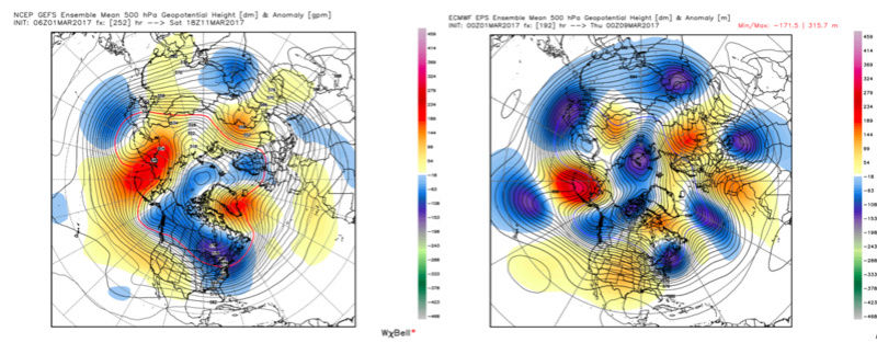
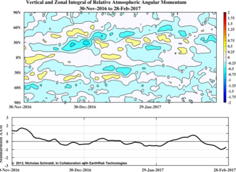
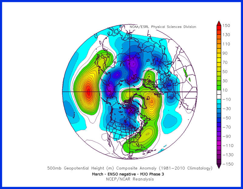
Here is your -AAM, both in polar and tropical domains. So, not only are we still in a NINA state of forcing, but you do have a decrease in westerlies, which supports the short term blocking period. So with this being said, is the EPS or GEFS correct? GEFS is a bit more sustained with that trough vs the EPS in and out. Right now, i'd probably lean in the middle, maybe towards the GEFS a bit. Another thing, we're about to see a constructive interference with the MJO and the low frequency forcing.
Lets check it out; March composite for eastern hemisphere forcing...
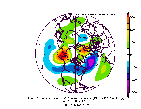
Now, lets look at the last time we had constructive interference and a MJO event passage back at the end of Jan. Look at the following 8-10 500mb ....
day
So, in conclusion, there is support for the EPS idea of a quick trough next week, in and out, and back to the NINA state. I question the intensity of the -NAO, but the pacific really is not going to help. Short term however, it appears one last winter shot this Friday for local areas, and a rather interesting clipper.

Armando Salvadore- Advanced Forecaster
- Posts : 171
Reputation : 0
Join date : 2016-12-23
Location : Springfield, NJ
Re: Long Range Thread 13.0
![]() by Armando Salvadore Wed Mar 01, 2017 10:43 am
by Armando Salvadore Wed Mar 01, 2017 10:43 am
Armando Salvadore- Advanced Forecaster
- Posts : 171
Reputation : 0
Join date : 2016-12-23
Location : Springfield, NJ
Re: Long Range Thread 13.0
![]() by Math23x7 Thu Mar 02, 2017 1:22 am
by Math23x7 Thu Mar 02, 2017 1:22 am
Math23x7- Wx Statistician Guru

- Posts : 2379
Reputation : 68
Join date : 2013-01-08
Re: Long Range Thread 13.0
![]() by Isotherm Thu Mar 02, 2017 3:13 pm
by Isotherm Thu Mar 02, 2017 3:13 pm
Isotherm- Advanced Forecaster
- Posts : 231
Reputation : 4
Join date : 2014-09-01
Age : 33
Location : Monmouth County, NJ -
Re: Long Range Thread 13.0
![]() by algae888 Thu Mar 02, 2017 4:23 pm
by algae888 Thu Mar 02, 2017 4:23 pm
algae888- Advanced Forecaster
- Posts : 5311
Reputation : 46
Join date : 2013-02-05
Age : 61
Location : mt. vernon, new york
Page 31 of 40 • 1 ... 17 ... 30, 31, 32 ... 35 ... 40 ![]()
|
|
|