
 Search
March 14, 2017 Roidzilla 1st Call Snow Map / Synopsis
Page 13 of 33 •  1 ... 8 ... 12, 13, 14 ... 23 ... 33
 ![]()
Re: March 14, 2017 Roidzilla 1st Call Snow Map / Synopsis
![]() by Frank_Wx Mon Mar 13, 2017 7:58 am
by Frank_Wx Mon Mar 13, 2017 7:58 am

Frank_Wx- Godzilla Seeker

- Posts : 21305
Join date : 2013-01-05 -

Re: March 14, 2017 Roidzilla 1st Call Snow Map / Synopsis
![]() by Frank_Wx Mon Mar 13, 2017 7:59 am
by Frank_Wx Mon Mar 13, 2017 7:59 am


Frank_Wx- Godzilla Seeker
- Posts : 21305
Join date : 2013-01-05 -
Re: March 14, 2017 Roidzilla 1st Call Snow Map / Synopsis
![]() by Guest Mon Mar 13, 2017 8:00 am
by Guest Mon Mar 13, 2017 8:00 am
Guest- Guest
Re: March 14, 2017 Roidzilla 1st Call Snow Map / Synopsis
![]() by Frank_Wx Mon Mar 13, 2017 8:04 am
by Frank_Wx Mon Mar 13, 2017 8:04 am
syosnow94 wrote:Not gonna lie. I just saw the 850 EURO temps and actually got sick and light-headed for real. I think the coast is in bad shape and the NAM which everyone wanted to throw out was on to something 2 days ago.
We threw out runs that showed clear convective feedback errors with the surface low, not one's that showed a warm solution.
_________________
_______________________________________________________________________________________________________
CLICK HERE to view NJ Strong Snowstorm Classifications

Frank_Wx- Godzilla Seeker
- Posts : 21305
Reputation : 328
Join date : 2013-01-05
Age : 31
Location : Jersey City, NJ -
Re: March 14, 2017 Roidzilla 1st Call Snow Map / Synopsis
![]() by devsman Mon Mar 13, 2017 8:05 am
by devsman Mon Mar 13, 2017 8:05 am

devsman- Pro Enthusiast

- Posts : 424
Reputation : 4
Join date : 2014-01-01
Age : 48
Location : merrick, ny (south shore of Long Island)
Re: March 14, 2017 Roidzilla 1st Call Snow Map / Synopsis
![]() by bobjohnsonforthehall Mon Mar 13, 2017 8:07 am
by bobjohnsonforthehall Mon Mar 13, 2017 8:07 am
Frank_Wx wrote:Roidzilla is brewing
That water vapor map is a thing of true beauty.

bobjohnsonforthehall- Posts : 311
Reputation : 19
Join date : 2016-10-02
Location : Flemington NJ
Re: March 14, 2017 Roidzilla 1st Call Snow Map / Synopsis
![]() by Guest Mon Mar 13, 2017 8:08 am
by Guest Mon Mar 13, 2017 8:08 am
Guest- Guest
Re: March 14, 2017 Roidzilla 1st Call Snow Map / Synopsis
![]() by Frank_Wx Mon Mar 13, 2017 8:08 am
by Frank_Wx Mon Mar 13, 2017 8:08 am
devsman wrote:syo...we snow at insane rates for 8 hours before any change over. Enjoy that and then worry about final numbers. We've hit the jackpot On long Island for years now...but coastal rain also comes with the territory.
Great post.
Especially in March. Gotta take into account Climo.
_________________
_______________________________________________________________________________________________________
CLICK HERE to view NJ Strong Snowstorm Classifications
Frank_Wx- Godzilla Seeker
- Posts : 21305
Reputation : 328
Join date : 2013-01-05
Age : 31
Location : Jersey City, NJ -
Re: March 14, 2017 Roidzilla 1st Call Snow Map / Synopsis
![]() by Frank_Wx Mon Mar 13, 2017 8:09 am
by Frank_Wx Mon Mar 13, 2017 8:09 am
TheAresian wrote:Are the 850 temps what determine ratios?
Gotta look at temps at all layers, but I like 925mb.
_________________
_______________________________________________________________________________________________________
CLICK HERE to view NJ Strong Snowstorm Classifications
Frank_Wx- Godzilla Seeker
- Posts : 21305
Reputation : 328
Join date : 2013-01-05
Age : 31
Location : Jersey City, NJ -
Re: March 14, 2017 Roidzilla 1st Call Snow Map / Synopsis
![]() by amugs Mon Mar 13, 2017 8:11 am
by amugs Mon Mar 13, 2017 8:11 am
JB said 3-4 days ago storm to Delmarva off ACy and then ENE - not a coastal hugger.
@Frank - work whats that? Just here physically came up with a great project for my kids to do so I can work.................I mean post and track!!
Principal said twe'll be ready for Wednesday school opening - yuo may butt he rest of us may be digging out.
SYO - HAPPY BIRTHDAY GUY!! ENJOY THE DAY TRACKING!
SR models are going to be insane today like last night -PARA NAM, HI RES and RGEM and GEM LAM
_________________
Mugs
AKA:King: Snow Weenie
Self Proclaimed
WINTER 2014-15 : 55.12" +.02 for 6 coatings (avg. 35")
WINTER 2015-16 Total - 29.8" (Avg 35")
WINTER 2016-17 : 39.5" so far

amugs- Advanced Forecaster - Mod

- Posts : 15093
Reputation : 213
Join date : 2013-01-07
Age : 54
Location : Hillsdale,NJ
Re: March 14, 2017 Roidzilla 1st Call Snow Map / Synopsis
![]() by Guest Mon Mar 13, 2017 8:11 am
by Guest Mon Mar 13, 2017 8:11 am
Guest- Guest
Re: March 14, 2017 Roidzilla 1st Call Snow Map / Synopsis
![]() by Sferra01 Mon Mar 13, 2017 8:13 am
by Sferra01 Mon Mar 13, 2017 8:13 am
sroc4 wrote:Morning Ladies and Gents. Here is my first call snow map. Likely last call unless something drastic happens. Obviously a last minute job to the east shifts these totals down closer to the coast. With such an intense dynamic system there will likely be unexpected totals be it higher or lower than expected.
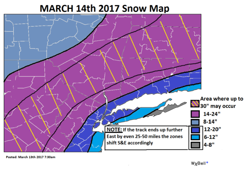
Sorry for the stupid question, but at approximately what town on the north shore east is your cut off?? I always have a hard time figuring out where my town lies on these maps....lol
Sferra01- Posts : 46
Reputation : 0
Join date : 2013-01-13
Location : Kings Park, NY
Re: March 14, 2017 Roidzilla 1st Call Snow Map / Synopsis
![]() by sroc4 Mon Mar 13, 2017 8:16 am
by sroc4 Mon Mar 13, 2017 8:16 am
SNOW MAN wrote:sroc4 wrote:Morning Ladies and Gents. Here is my first call snow map. Likely last call unless something drastic happens. Obviously a last minute job to the east shifts these totals down closer to the coast. With such an intense dynamic system there will likely be unexpected totals be it higher or lower than expected.
Doc, you did it to me again. I can't see the state line of PA. and N. J. LOL !!!
Sorry snow. Lol. I thought of that when I made it. I didn't have a lot of time this am.
_________________
"In weather and in life, there's no winning and losing; there's only winning and learning."
WINTER 2012/2013 TOTALS 43.65"WINTER 2017/2018 TOTALS 62.85" WINTER 2022/2023 TOTALS 4.9"
WINTER 2013/2014 TOTALS 64.85"WINTER 2018/2019 TOTALS 14.25" WINTER 2023/2024 TOTALS 13.1"
WINTER 2014/2015 TOTALS 71.20"WINTER 2019/2020 TOTALS 6.35"
WINTER 2015/2016 TOTALS 35.00"WINTER 2020/2021 TOTALS 37.75"
WINTER 2016/2017 TOTALS 42.25"WINTER 2021/2022 TOTALS 31.65"

sroc4- Admin
- Posts : 8331
Reputation : 301
Join date : 2013-01-07
Location : Wading River, LI
Re: March 14, 2017 Roidzilla 1st Call Snow Map / Synopsis
![]() by skinsfan1177 Mon Mar 13, 2017 8:18 am
by skinsfan1177 Mon Mar 13, 2017 8:18 am

skinsfan1177- Senior Enthusiast

- Posts : 4485
Reputation : 35
Join date : 2013-01-07
Age : 46
Location : Point Pleasant Boro
Re: March 14, 2017 Roidzilla 1st Call Snow Map / Synopsis
![]() by amugs Mon Mar 13, 2017 8:19 am
by amugs Mon Mar 13, 2017 8:19 am
skinsfan1177 wrote:We need 12z east tick please
Skins these storms of this magnitude usually do tick east from experience 10 mile? 20 mile?
_________________
Mugs
AKA:King: Snow Weenie
Self Proclaimed
WINTER 2014-15 : 55.12" +.02 for 6 coatings (avg. 35")
WINTER 2015-16 Total - 29.8" (Avg 35")
WINTER 2016-17 : 39.5" so far
amugs- Advanced Forecaster - Mod
- Posts : 15093
Reputation : 213
Join date : 2013-01-07
Age : 54
Location : Hillsdale,NJ
Re: March 14, 2017 Roidzilla 1st Call Snow Map / Synopsis
![]() by sroc4 Mon Mar 13, 2017 8:20 am
by sroc4 Mon Mar 13, 2017 8:20 am
Sferra01 wrote:sroc4 wrote:Morning Ladies and Gents. Here is my first call snow map. Likely last call unless something drastic happens. Obviously a last minute job to the east shifts these totals down closer to the coast. With such an intense dynamic system there will likely be unexpected totals be it higher or lower than expected.
Sorry for the stupid question, but at approximately what town on the north shore east is your cut off?? I always have a hard time figuring out where my town lies on these maps....lol
Not stupid. Port Jeff harbor. My gut is telling me final track ends up a tad further east than guidance shows now. Meaning the eastern half of LI totals go up. I do think though that LI and even NYC will change over for at least some time.
_________________
"In weather and in life, there's no winning and losing; there's only winning and learning."
WINTER 2012/2013 TOTALS 43.65"WINTER 2017/2018 TOTALS 62.85" WINTER 2022/2023 TOTALS 4.9"
WINTER 2013/2014 TOTALS 64.85"WINTER 2018/2019 TOTALS 14.25" WINTER 2023/2024 TOTALS 13.1"
WINTER 2014/2015 TOTALS 71.20"WINTER 2019/2020 TOTALS 6.35"
WINTER 2015/2016 TOTALS 35.00"WINTER 2020/2021 TOTALS 37.75"
WINTER 2016/2017 TOTALS 42.25"WINTER 2021/2022 TOTALS 31.65"
sroc4- Admin
- Posts : 8331
Reputation : 301
Join date : 2013-01-07
Location : Wading River, LI
Re: March 14, 2017 Roidzilla 1st Call Snow Map / Synopsis
![]() by track17 Mon Mar 13, 2017 8:22 am
by track17 Mon Mar 13, 2017 8:22 am
track17- Posts : 454
Reputation : 4
Join date : 2016-01-09
Re: March 14, 2017 Roidzilla 1st Call Snow Map / Synopsis
![]() by SNOW MAN Mon Mar 13, 2017 8:23 am
by SNOW MAN Mon Mar 13, 2017 8:23 am
sroc4 wrote:SNOW MAN wrote:sroc4 wrote:Morning Ladies and Gents. Here is my first call snow map. Likely last call unless something drastic happens. Obviously a last minute job to the east shifts these totals down closer to the coast. With such an intense dynamic system there will likely be unexpected totals be it higher or lower than expected.
Doc, you did it to me again. I can't see the state line of PA. and N. J. LOL !!!
Sorry snow. Lol. I thought of that when I made it. I didn't have a lot of time this am.
Not a problem. I know this, I like your map for my area.

SNOW MAN- Senior Enthusiast
- Posts : 1361
Reputation : 25
Join date : 2013-01-13
Age : 64
Location : Marshalls Creek Pa.
Re: March 14, 2017 Roidzilla 1st Call Snow Map / Synopsis
![]() by rb924119 Mon Mar 13, 2017 8:24 am
by rb924119 Mon Mar 13, 2017 8:24 am
I think I found the reason that the NAM is blowing everything to pieces.......
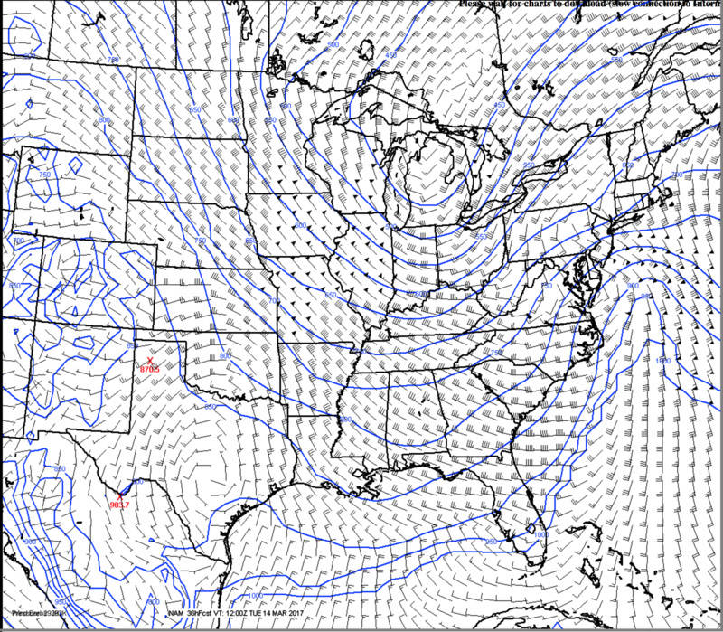
That's probably the best large-scale isentropic lift I've ever seen since learning about it years ago, with the rapid lower mid-level deceleration and subsequent convergence between the 700 and 650 hPa blue contours screaming for a mega-death band across all of EPA, extreme NW NJ and points NE. WOW if that holds.
rb924119- Meteorologist

- Posts : 6890
Reputation : 194
Join date : 2013-02-06
Age : 32
Location : Greentown, Pa
Re: March 14, 2017 Roidzilla 1st Call Snow Map / Synopsis
![]() by Guest Mon Mar 13, 2017 8:26 am
by Guest Mon Mar 13, 2017 8:26 am
Frank_Wx wrote:devsman wrote:syo...we snow at insane rates for 8 hours before any change over. Enjoy that and then worry about final numbers. We've hit the jackpot On long Island for years now...but coastal rain also comes with the territory.
Great post.
Especially in March. Gotta take into account Climo.
I know climatology. I actually posted yesterday that we've beaten the odds for years here on the coast and now it's time for the N and W folks to cash in. I GET IT. I just don't understand how so many people loved the NAM all winter when it showed snow, but those same people tossed it or discounted it the last 2 days, when it turns out the global models all trended towards it.
Guest- Guest
Re: March 14, 2017 Roidzilla 1st Call Snow Map / Synopsis
![]() by rb924119 Mon Mar 13, 2017 8:28 am
by rb924119 Mon Mar 13, 2017 8:28 am
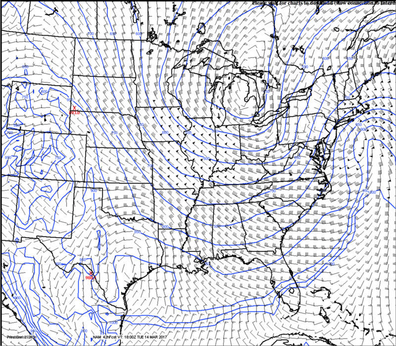
NE PA IS NUKED
rb924119- Meteorologist
- Posts : 6890
Reputation : 194
Join date : 2013-02-06
Age : 32
Location : Greentown, Pa
Re: March 14, 2017 Roidzilla 1st Call Snow Map / Synopsis
![]() by Guest Mon Mar 13, 2017 8:29 am
by Guest Mon Mar 13, 2017 8:29 am
Guest- Guest
Re: March 14, 2017 Roidzilla 1st Call Snow Map / Synopsis
![]() by Sferra01 Mon Mar 13, 2017 8:31 am
by Sferra01 Mon Mar 13, 2017 8:31 am
sroc4 wrote:Sferra01 wrote:sroc4 wrote:Morning Ladies and Gents. Here is my first call snow map. Likely last call unless something drastic happens. Obviously a last minute job to the east shifts these totals down closer to the coast. With such an intense dynamic system there will likely be unexpected totals be it higher or lower than expected.
Sorry for the stupid question, but at approximately what town on the north shore east is your cut off?? I always have a hard time figuring out where my town lies on these maps....lol
Not stupid. Port Jeff harbor. My gut is telling me final track ends up a tad further east than guidance shows now. Meaning the eastern half of LI totals go up. I do think though that LI and even NYC will change over for at least some time.
Thank you!!
Sferra01- Posts : 46
Reputation : 0
Join date : 2013-01-13
Location : Kings Park, NY
Re: March 14, 2017 Roidzilla 1st Call Snow Map / Synopsis
![]() by Frank_Wx Mon Mar 13, 2017 8:35 am
by Frank_Wx Mon Mar 13, 2017 8:35 am

_________________
_______________________________________________________________________________________________________
CLICK HERE to view NJ Strong Snowstorm Classifications
Frank_Wx- Godzilla Seeker
- Posts : 21305
Reputation : 328
Join date : 2013-01-05
Age : 31
Location : Jersey City, NJ -
Re: March 14, 2017 Roidzilla 1st Call Snow Map / Synopsis
![]() by Frank_Wx Mon Mar 13, 2017 8:36 am
by Frank_Wx Mon Mar 13, 2017 8:36 am

_________________
_______________________________________________________________________________________________________
CLICK HERE to view NJ Strong Snowstorm Classifications
Frank_Wx- Godzilla Seeker
- Posts : 21305
Reputation : 328
Join date : 2013-01-05
Age : 31
Location : Jersey City, NJ -
Re: March 14, 2017 Roidzilla 1st Call Snow Map / Synopsis
![]() by Guest Mon Mar 13, 2017 8:36 am
by Guest Mon Mar 13, 2017 8:36 am
Guest- Guest
Re: March 14, 2017 Roidzilla 1st Call Snow Map / Synopsis
![]() by Frank_Wx Mon Mar 13, 2017 8:37 am
by Frank_Wx Mon Mar 13, 2017 8:37 am
TheAresian wrote:I don't know if it means anything, but I was just checking out the HRRR 2m temps for the buildup and they're showing a bit warmer than the NAM has predicted. Is this a potential problem?
I think after today's 12z run we'll have a better idea of temps. We need to nail down the final track.
_________________
_______________________________________________________________________________________________________
CLICK HERE to view NJ Strong Snowstorm Classifications
Frank_Wx- Godzilla Seeker
- Posts : 21305
Reputation : 328
Join date : 2013-01-05
Age : 31
Location : Jersey City, NJ -
Page 13 of 33 • 1 ... 8 ... 12, 13, 14 ... 23 ... 33 ![]()
|
|
|