
 Search
Long Range Thread 15.0
Page 5 of 42 •  1, 2, 3, 4, 5, 6 ... 23 ... 42
 ![]()
Re: Long Range Thread 15.0
![]() by algae888 Sun Nov 05, 2017 12:32 pm
by algae888 Sun Nov 05, 2017 12:32 pm
algae888- Advanced Forecaster

- Posts : 5311
Join date : 2013-02-05
Re: Long Range Thread 15.0
![]() by amugs Sun Nov 05, 2017 1:17 pm
by amugs Sun Nov 05, 2017 1:17 pm
to this
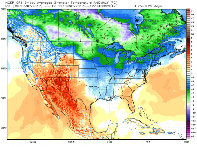
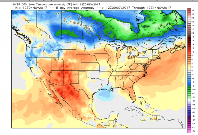
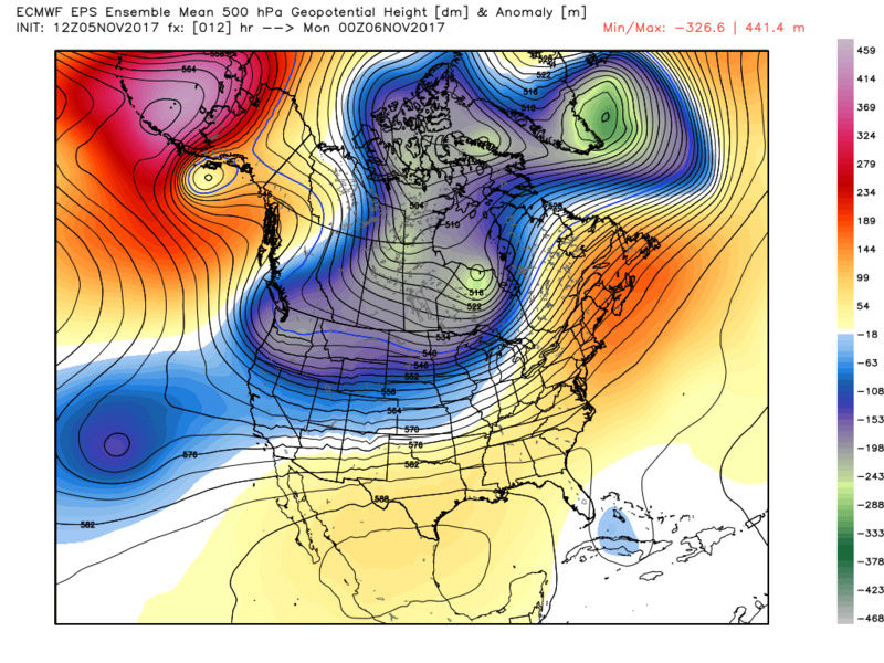
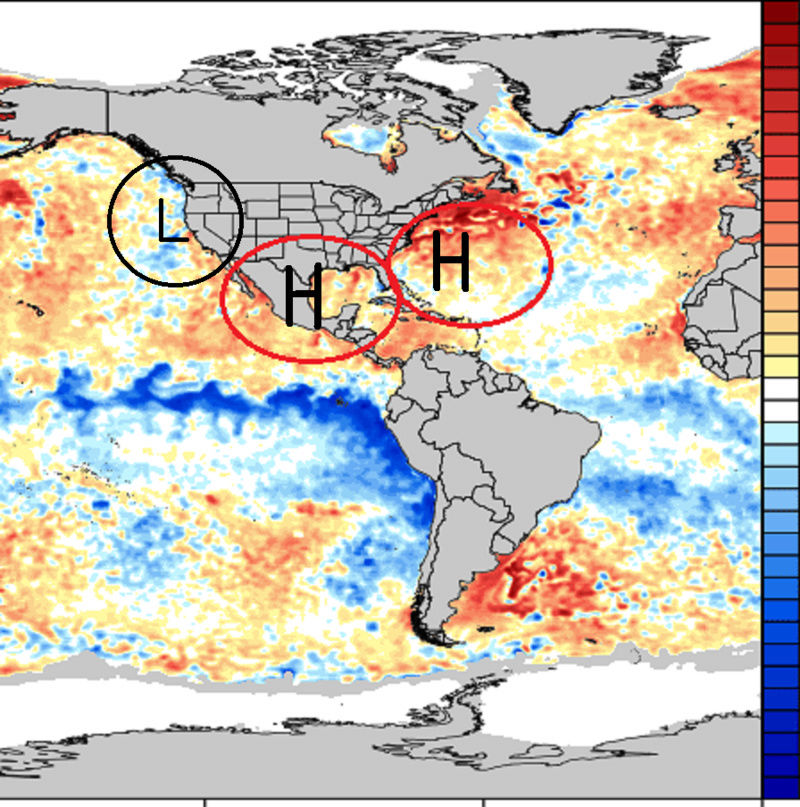
In the image you show above that is a N WPO and a Neutral EPO
with a Neutral PNA and a slight - NAO albeit weak but there so it may be fighting itself here.
So as you point out changes in models will be the rule and norm
If we go into the MJO pahses as per GEFS - we are warm, if we go via EURO we are about normal

Good news on the solar front as well
Spotless Days
Current Stretch: 4 days
2017 total: 72 days (23%)
2016 total: 32 days (9%)
2015 total: 0 days (0%)
2014 total: 1 day (<1%)
2013 total: 0 days (0%)
2012 total: 0 days (0%)
2011 total: 2 days (<1%)
2010 total: 51 days (14%)
2009 total: 260 days (71%)
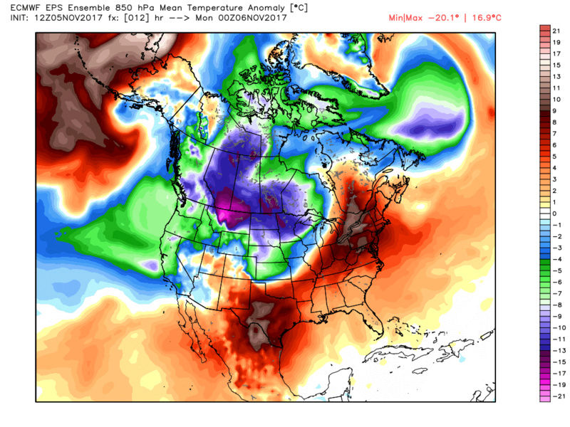
Warmth fighting cold in Trop PAC
EAST BASED NINA
amugs- Advanced Forecaster - Mod

- Posts : 15093
Join date : 2013-01-07
Re: Long Range Thread 15.0
![]() by algae888 Sun Nov 05, 2017 3:47 pm
by algae888 Sun Nov 05, 2017 3:47 pm
Partly sunny, with a high near 54. North wind 5 to 10 mph becoming light northeast in the afternoon.
Tuesday Night
Mostly cloudy, with a low around 39.
Wednesday
Partly sunny, with a high near 54.
Wednesday Night
Partly cloudy, with a low around 41.
Thursday
Mostly sunny, with a high near 54.
Thursday Night
Mostly cloudy, with a low around 41.
Friday
Mostly sunny, with a high near 51.
Friday Night
Partly cloudy, with a low around 31.
Veterans Day
Mostly sunny, with a high near 47.
Saturday Night
A 30 percent chance of snow showers. Mostly cloudy, with a low around 35.
Sunday
A chance of rain and snow showers. Mostly cloudy, with a high near 51.

algae888- Advanced Forecaster
- Posts : 5311
Reputation : 46
Join date : 2013-02-05
Age : 61
Location : mt. vernon, new york
Re: Long Range Thread 15.0
![]() by algae888 Sun Nov 05, 2017 4:18 pm
by algae888 Sun Nov 05, 2017 4:18 pm

algae888- Advanced Forecaster
- Posts : 5311
Reputation : 46
Join date : 2013-02-05
Age : 61
Location : mt. vernon, new york
Re: Long Range Thread 15.0
![]() by algae888 Sun Nov 05, 2017 5:07 pm
by algae888 Sun Nov 05, 2017 5:07 pm
A rather tranquil period is expected for most of the long term
period. A mainly zonal upper flow will dominate with surface high
pressure building across the region. For now will keep the area dry
Thursday and Thursday night as an upper shortwave passes to the
south and a deep northern trough passes to the north. Will have
probabilities across the ocean waters Thursday night. There is a
possibility that the southern stream passes farther to the north or
the northern trough digs deeper into the mid Atlantic. A strong and
cold Canadian high pressure builds into the region Friday and Friday
night and passes through Saturday. Widespread freezing temperatures
are likely Friday night, with freezing temperatures again Saturday
night. Highs Friday will be nearly 10 degrees below normal.
Sunday another shortwave with more energy is expected to pass
through the area Sunday and Sunday night. With the cold airmass
retreating and modifying Sunday precipitation could potentially
begin as snow and/or rain inland with a mix possibly even down to
the coast early Sunday.
algae888- Advanced Forecaster
- Posts : 5311
Reputation : 46
Join date : 2013-02-05
Age : 61
Location : mt. vernon, new york
Re: Long Range Thread 15.0
![]() by algae888 Sun Nov 05, 2017 5:18 pm
by algae888 Sun Nov 05, 2017 5:18 pm

algae888- Advanced Forecaster
- Posts : 5311
Reputation : 46
Join date : 2013-02-05
Age : 61
Location : mt. vernon, new york
Re: Long Range Thread 15.0
![]() by amugs Sun Nov 05, 2017 5:39 pm
by amugs Sun Nov 05, 2017 5:39 pm
_________________
Mugs
AKA:King: Snow Weenie
Self Proclaimed
WINTER 2014-15 : 55.12" +.02 for 6 coatings (avg. 35")
WINTER 2015-16 Total - 29.8" (Avg 35")
WINTER 2016-17 : 39.5" so far

amugs- Advanced Forecaster - Mod
- Posts : 15093
Reputation : 213
Join date : 2013-01-07
Age : 54
Location : Hillsdale,NJ
Re: Long Range Thread 15.0
![]() by Snow88 Sun Nov 05, 2017 6:30 pm
by Snow88 Sun Nov 05, 2017 6:30 pm
December is going to be a wintry month

Snow88- Senior Enthusiast

- Posts : 2193
Reputation : 4
Join date : 2013-01-09
Age : 35
Location : Brooklyn, NY
Re: Long Range Thread 15.0
![]() by amugs Sun Nov 05, 2017 9:00 pm
by amugs Sun Nov 05, 2017 9:00 pm
December is going to be a wintry month[/quote
Tony FIOS??
Low solar and E WBO = HL Blocking
It is showing up on hemispherical model runs and will do going forward.
_________________
Mugs
AKA:King: Snow Weenie
Self Proclaimed
WINTER 2014-15 : 55.12" +.02 for 6 coatings (avg. 35")
WINTER 2015-16 Total - 29.8" (Avg 35")
WINTER 2016-17 : 39.5" so far
amugs- Advanced Forecaster - Mod
- Posts : 15093
Reputation : 213
Join date : 2013-01-07
Age : 54
Location : Hillsdale,NJ
Re: Long Range Thread 15.0
![]() by sroc4 Mon Nov 06, 2017 7:38 am
by sroc4 Mon Nov 06, 2017 7:38 am
algae888 wrote:Yes Scott I understand what you're saying but I would still like to see high pressure over the pole in Greenland which should be in conjunction with upper level Ridge. Also by January the wavelengths will be much longer and allow the cold air to come east that weird looking tucked in negative PNA right now will not look the same in January with the negative wpo / EPO and I very much disagree that November will be + 2 to + 5 I'm looking more zero two plus two. The GFS and CMC have come back to the euro idea of arctic front next week and most long-range guidance looks cold Beyond day 7 and stormy at that with the mjo it looks to be in The Circle of Death for the foreseeable future so very little influence on the pattern there. Just my two cents. what's looking eerily similar is 1995 flip from the very warm October to the very cold November through the rest of the winter not saying that's going to happen this year and very highly unlikely too but if guidance is correct looks eerily similar
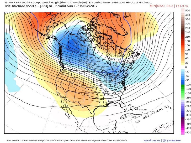
Thus far Al I feel I have been pretty spot on with the big picture. Here we are 00z on the 6th and this was the discussion and maps from the 22nd of Oct.
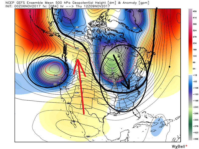
Now lets look at the modeling. Again we have a recurving typhoon and an MJO wave amplification through phases 5-6(which favor cold in the east this time of year) that will amplify the pattern such that by next week we get a nice cold shot. This is agreed upon in both the EPS and GEFS camps.
But unfortunately that seems to only lasts a few days before we rebound into the warm sector
Then the question is to we go back to the cold pattern? Again I would argue that as we get closer in time we cont to see a trend away from below normal anomalies and move more towards the normal to above normal anomalies in the modeling. That trend already has begun esp in the Euro ens. There is a negative anomaly that is consistently showing up off the SW coast. By day ten on the EPS you can see it aids in the enhancement of the STJ and leads to the Mean trough to be further west over the CONUS in a progressive orientation. This in turn enhances the SE ridge such that it puts us into the SW flow aloft. Day 13 and day 15 hint at a similar orientation.
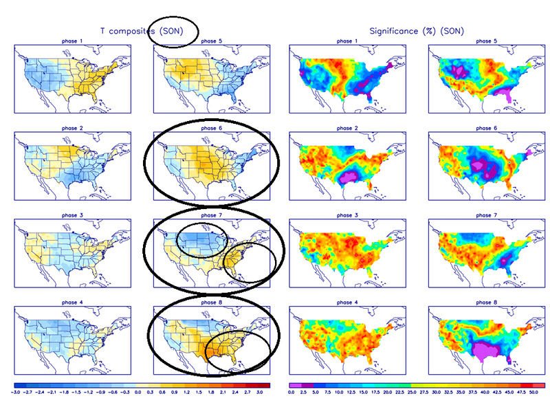
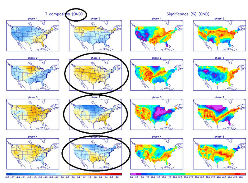
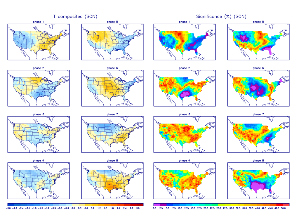
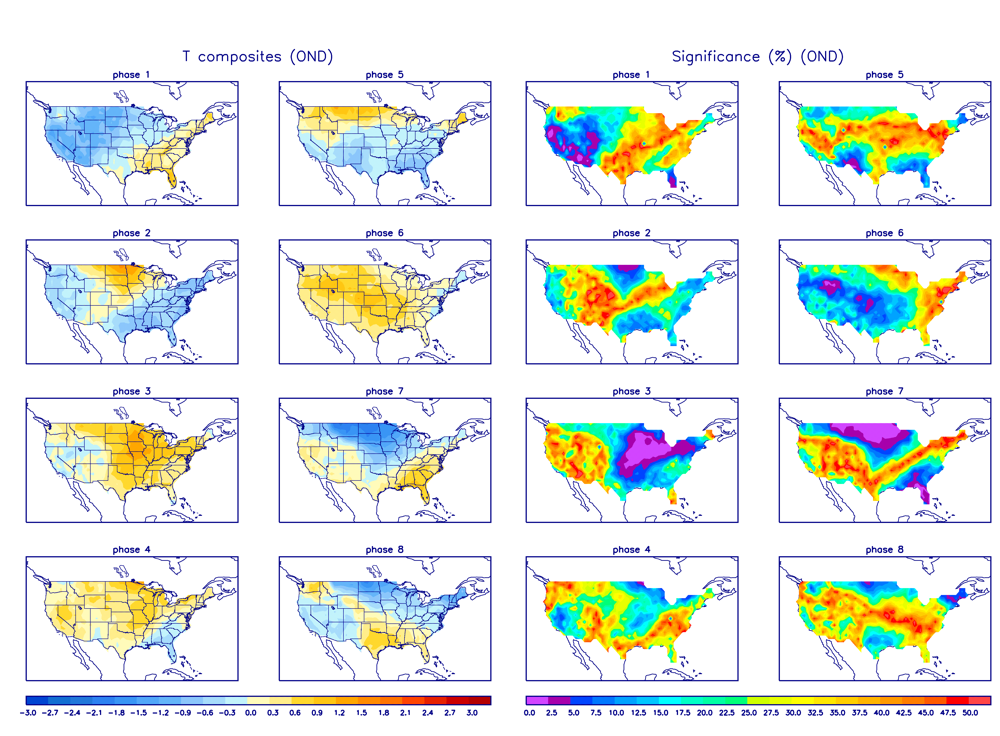
Does this make sense though? Again I argue yes. First off we have the underlying base state that is La Nina like which tends to favor a western trough S Eastern ridge configuration. Look back at the MJO forecasts above. Now see below the MJO temp composites. Below are the differences between the composites for the Sept/Oct/Nov vs the Oct/Nov/Dec period. Both on avg favor the SE ridge over our area in phase 7, but the SON composite also indicates a warm pattern in the east in phase 8 as well. This actually matches up nicely with the look on the Euro ensembles day 10-15 as we end Oct and head into the first week of Nov. The O/N/D composite does seem to favor cooler temp anomalies in the east however in phase 8 suppressing the SE ridge.
As you can see below the GEFS are a little different in the same time frame regarding the configurations of the Mean trough and ridge. You can see day 10(hr 240) the SE ridge is centered off the EC in the Atlantic and the mean trough is further east. However reading between the lines I do believe the euro camp may be more correct with its trough ridge orientation in this time frame. I still think given the base state of the atmosphere and the current MJO forecasts sustained cold in the east is not in the cards just yet through the first 1-2 weeks of Nov. Again I REALLY hope I'm wrong but I just don't see it yet.
EPS vs GEFs from OCT 22nd vs actual for 00z Nov 6th
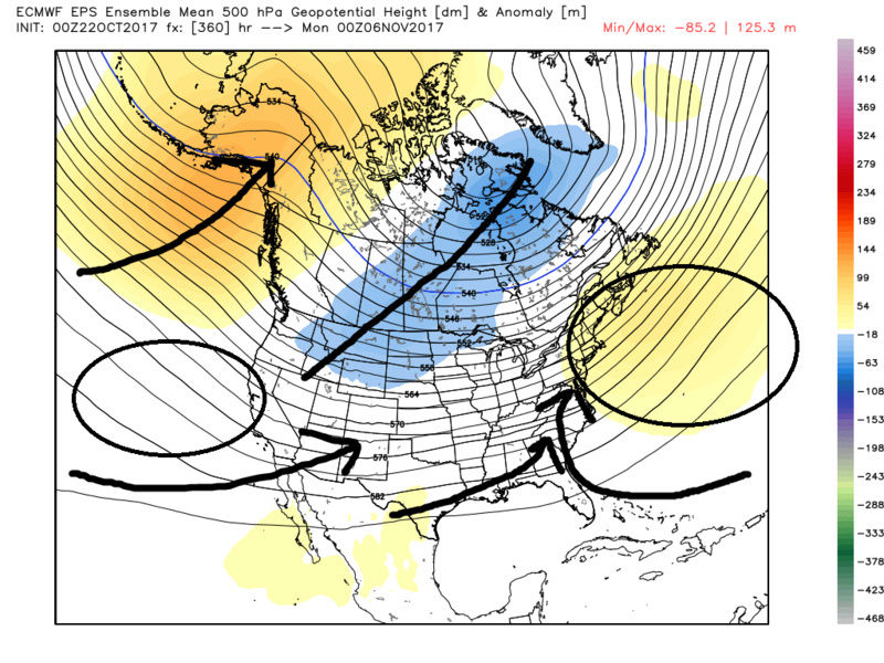
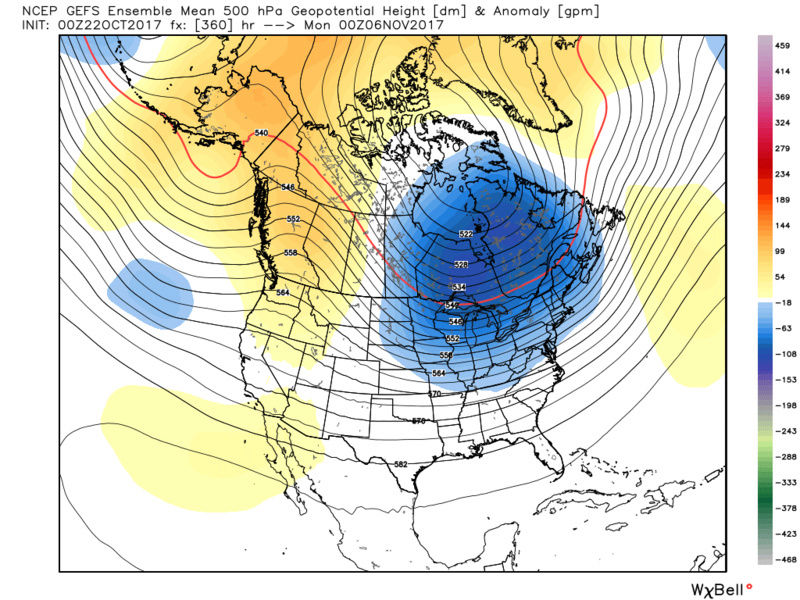
The GEFS clearly corrected to the EPS...this time.
Looking ahead this cold shot coming up late this weekend was also not unpredicted and actually is a very nice reflection of where the MJO is headed. IF the MJO does in fact get into phase 2 then a decent cold shot is def possible. The past 7days the GFS has actually been better at handling the MJO outcome so the cool shot coming in a week or so may be real..... The -PNA has been and will continue to be a thorn in our side this month and likely into early Dec. Again a favorable MJO impulse can influence the mean pattern such that a transient pull back of the western trough could allow a ridge to go up in the PNA region. With the -WPO and -EPO locked in for the time being as Al points out if there is any ridging in the west the cold air spills east even with a +NAO and +AO. We will likely see this happen heading into next weekend.
.
Here we are with a nice pull back of the WC trough and a small but sufficient WC ridge show up enough to discharge a piece of energy across the country allowing the mean trough to bring us that cold Canadian air.
So where is the MJO headed? As you can see the GFS has it run through phases 2-3-4-5 whereas the Euro wants to take it out in 5. Again the GFS has been leading the way here over the past 10-14days and the euro has been playing catch up...with the MJO forecasts.
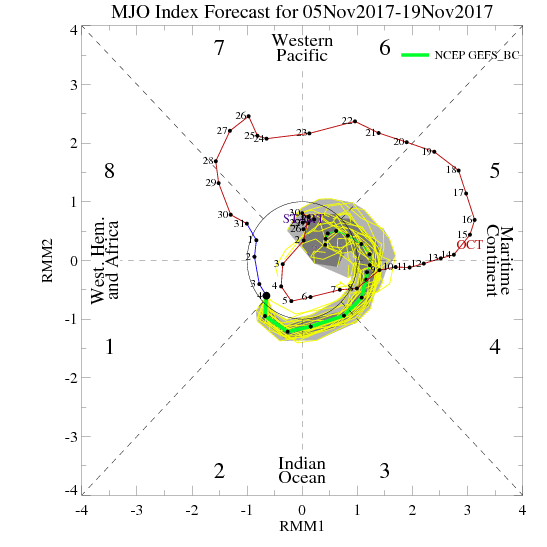

If we look back at the Temp composites you will see that the Phase 2 for SON AND OND you notice phase 2 is a cold phase. Keep in mind we are in Nov. So technically you can look at the temp composite for Sept/Oct/Nov or Oct/Nov/Dec or Nov/Dec/Jan. So what happens when or if the MJO propagates east through phases 3-4-5? The reason I hesitate to simply jump aboard the ship of cold locked in is this. As I also stated earlier in a write up my fear for this winter is that the SSTA alignment in the Trop/N Pac, IO, and Atlantic is such that a recycling MJO in the phases 3-6 is possible,at least it is in these phases the majority of the time. So far that has been true. If the atmosphere and the wavelengths are still configured to the SON temp composite avgs then after this serious cold shot this weekend we likely go back to more normal temps maybe -1 and o along with your idea of cold locked in if normal to -1 is what you call locked in. But if the atmosphere is starting to transition into the O/N/D temp comp avgs then we will see the temps in the east move back towards at least +2 to +5, likely higher as the air masses on the SW flow is still extremely warm coming out of the south. And as you can see below if we cont to recycle the MJO through any of these phases as we head deeper into the season we will not see sustained cold in the east without something else influencing our pattern. Plain and simple the amplified MJO has taken over the drivers seat for the time being and is running the pattern. I will say this the LR GEFS and the EPS show a decent signal for an actual neg NAO for the first time, but as we have seen already the LR needs to be looked at cautiously and not bought into as gospel.
Al. I am not looking to argue with you regarding what's going to happen going forward. I simply say it how I see it. Again I appreciate you disagreeing with me as it forces me to rethink my ideas. My own statements about the MJO is one that has me looking at the fact that November temps closer to normal overall like you have been saying is possible given the logic I stated above. But I will not be disappointed in hoping for cold and then having it be warm when there is very sound reasoning as to how the warm can win out overall which seems to have been the theme for the last several years. With an overall warming climate this has to be taken into consideration.
_________________
"In weather and in life, there's no winning and losing; there's only winning and learning."
WINTER 2012/2013 TOTALS 43.65"WINTER 2017/2018 TOTALS 62.85" WINTER 2022/2023 TOTALS 4.9"
WINTER 2013/2014 TOTALS 64.85"WINTER 2018/2019 TOTALS 14.25" WINTER 2023/2024 TOTALS 13.1"
WINTER 2014/2015 TOTALS 71.20"WINTER 2019/2020 TOTALS 6.35"
WINTER 2015/2016 TOTALS 35.00"WINTER 2020/2021 TOTALS 37.75"
WINTER 2016/2017 TOTALS 42.25"WINTER 2021/2022 TOTALS 31.65"

sroc4- Admin

- Posts : 8331
Reputation : 301
Join date : 2013-01-07
Location : Wading River, LI
Re: Long Range Thread 15.0
![]() by sroc4 Mon Nov 06, 2017 9:04 am
by sroc4 Mon Nov 06, 2017 9:04 am
_________________
"In weather and in life, there's no winning and losing; there's only winning and learning."
WINTER 2012/2013 TOTALS 43.65"WINTER 2017/2018 TOTALS 62.85" WINTER 2022/2023 TOTALS 4.9"
WINTER 2013/2014 TOTALS 64.85"WINTER 2018/2019 TOTALS 14.25" WINTER 2023/2024 TOTALS 13.1"
WINTER 2014/2015 TOTALS 71.20"WINTER 2019/2020 TOTALS 6.35"
WINTER 2015/2016 TOTALS 35.00"WINTER 2020/2021 TOTALS 37.75"
WINTER 2016/2017 TOTALS 42.25"WINTER 2021/2022 TOTALS 31.65"
sroc4- Admin
- Posts : 8331
Reputation : 301
Join date : 2013-01-07
Location : Wading River, LI
Re: Long Range Thread 15.0
![]() by algae888 Mon Nov 06, 2017 9:52 am
by algae888 Mon Nov 06, 2017 9:52 am
algae888- Advanced Forecaster
- Posts : 5311
Reputation : 46
Join date : 2013-02-05
Age : 61
Location : mt. vernon, new york
Re: Long Range Thread 15.0
![]() by algae888 Mon Nov 06, 2017 9:55 am
by algae888 Mon Nov 06, 2017 9:55 am
A negative PNA along with the negative Ao and Nao will be more favorable than if the PNA was positive. The latter would be cold and dry the former a lot of over running events. I'm not overly concerned with the PNA at this timesroc4 wrote:A fear I have is that the warm SSTA off the WC of Mexico, GOA/Caribbean and in the western Atlantic combined with the colder anomalies off the WC CONUS it will be very easy for the Atlantic Ridge and the Ridge over Mexico/Tx to flex and the -PNA/trough west configuration resume should there be unfavorable MJO phases, or Stratosphere temp or positioning etc.
algae888- Advanced Forecaster
- Posts : 5311
Reputation : 46
Join date : 2013-02-05
Age : 61
Location : mt. vernon, new york
Re: Long Range Thread 15.0
![]() by Frank_Wx Mon Nov 06, 2017 10:22 am
by Frank_Wx Mon Nov 06, 2017 10:22 am
_________________
_______________________________________________________________________________________________________
CLICK HERE to view NJ Strong Snowstorm Classifications

Frank_Wx- Godzilla Seeker
- Posts : 21305
Reputation : 328
Join date : 2013-01-05
Age : 31
Location : Jersey City, NJ -

Re: Long Range Thread 15.0
![]() by amugs Mon Nov 06, 2017 3:45 pm
by amugs Mon Nov 06, 2017 3:45 pm
This is what low solar and e qbo can help with
_________________
Mugs
AKA:King: Snow Weenie
Self Proclaimed
WINTER 2014-15 : 55.12" +.02 for 6 coatings (avg. 35")
WINTER 2015-16 Total - 29.8" (Avg 35")
WINTER 2016-17 : 39.5" so far
amugs- Advanced Forecaster - Mod
- Posts : 15093
Reputation : 213
Join date : 2013-01-07
Age : 54
Location : Hillsdale,NJ
Re: Long Range Thread 15.0
![]() by algae888 Mon Nov 06, 2017 4:16 pm
by algae888 Mon Nov 06, 2017 4:16 pm
Yes mugs it is looking increasingly likely that we will have a cold stretch give or take a day from the 20th of November going forward the AO is going to Plummet with the negative Nao and negative wpo will displace the polar vortex into Canada. very early in the season for this to happen November could end up well below normal if ensemble guidance is correct. Very 1995-96 esqueamugs wrote:EPS say SE Ridge say what??
This is what low solar and e qbo can help with
algae888- Advanced Forecaster
- Posts : 5311
Reputation : 46
Join date : 2013-02-05
Age : 61
Location : mt. vernon, new york
Re: Long Range Thread 15.0
![]() by Snow88 Mon Nov 06, 2017 4:42 pm
by Snow88 Mon Nov 06, 2017 4:42 pm
AO is tanking
NAO is dropping
PNA is rising towards neutral
Snow88- Senior Enthusiast
- Posts : 2193
Reputation : 4
Join date : 2013-01-09
Age : 35
Location : Brooklyn, NY
Re: Long Range Thread 15.0
![]() by algae888 Mon Nov 06, 2017 4:57 pm
by algae888 Mon Nov 06, 2017 4:57 pm

we are due for a neg nao ao in the means for a winter season. I believe the last time they were was 2010/11.
algae888- Advanced Forecaster
- Posts : 5311
Reputation : 46
Join date : 2013-02-05
Age : 61
Location : mt. vernon, new york
Re: Long Range Thread 15.0
![]() by amugs Mon Nov 06, 2017 6:57 pm
by amugs Mon Nov 06, 2017 6:57 pm


GEFS barking at the 19th onward

EPS and GEFS barking at this time frame.
_________________
Mugs
AKA:King: Snow Weenie
Self Proclaimed
WINTER 2014-15 : 55.12" +.02 for 6 coatings (avg. 35")
WINTER 2015-16 Total - 29.8" (Avg 35")
WINTER 2016-17 : 39.5" so far
amugs- Advanced Forecaster - Mod
- Posts : 15093
Reputation : 213
Join date : 2013-01-07
Age : 54
Location : Hillsdale,NJ
Re: Long Range Thread 15.0
![]() by sroc4 Mon Nov 06, 2017 8:10 pm
by sroc4 Mon Nov 06, 2017 8:10 pm
algae888 wrote:when was the last late fall/winter that we saw this....
we are due for a neg nao ao in the means for a winter season. I believe the last time they were was 2010/11.
I have to admit this is impressive. The NAO ens is equally. If this is for real we could have a late Nov snow storm like Snow pointed out.
_________________
"In weather and in life, there's no winning and losing; there's only winning and learning."
WINTER 2012/2013 TOTALS 43.65"WINTER 2017/2018 TOTALS 62.85" WINTER 2022/2023 TOTALS 4.9"
WINTER 2013/2014 TOTALS 64.85"WINTER 2018/2019 TOTALS 14.25" WINTER 2023/2024 TOTALS 13.1"
WINTER 2014/2015 TOTALS 71.20"WINTER 2019/2020 TOTALS 6.35"
WINTER 2015/2016 TOTALS 35.00"WINTER 2020/2021 TOTALS 37.75"
WINTER 2016/2017 TOTALS 42.25"WINTER 2021/2022 TOTALS 31.65"
sroc4- Admin
- Posts : 8331
Reputation : 301
Join date : 2013-01-07
Location : Wading River, LI
Re: Long Range Thread 15.0
![]() by dkodgis Mon Nov 06, 2017 8:14 pm
by dkodgis Mon Nov 06, 2017 8:14 pm

dkodgis- Senior Enthusiast
- Posts : 2493
Reputation : 98
Join date : 2013-12-29
Re: Long Range Thread 15.0
![]() by amugs Mon Nov 06, 2017 8:39 pm
by amugs Mon Nov 06, 2017 8:39 pm
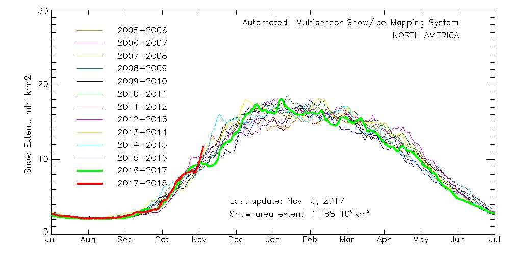
We have a N EPO - the pig eye trough that we could not budge last year up in Alaska is going back into W Russia which will allow the PEO to pump the PNA as well. WE have Low solar as pointed out numerous times with an East Based Nina in a pretty moderate way with a High Lattitude blocking - this set up feeds off itself.
Snow cover - awesome sign!!
_________________
Mugs
AKA:King: Snow Weenie
Self Proclaimed
WINTER 2014-15 : 55.12" +.02 for 6 coatings (avg. 35")
WINTER 2015-16 Total - 29.8" (Avg 35")
WINTER 2016-17 : 39.5" so far
amugs- Advanced Forecaster - Mod
- Posts : 15093
Reputation : 213
Join date : 2013-01-07
Age : 54
Location : Hillsdale,NJ
Re: Long Range Thread 15.0
![]() by Math23x7 Mon Nov 06, 2017 9:48 pm
by Math23x7 Mon Nov 06, 2017 9:48 pm
However, I must also keep in mind the 2007-08 analog I have been mentioning before. Recall that from mid-November to mid-December in 2007, we had a cold stretch with a couple of inches of snow and it seemed like an exciting winter was in store. A week before Christmas, however, we entered a prolonged stretch of above normal temperatures. Outside of two transient cold snaps (one around January 2nd, the other around January 21st), it was a blowtorch through the second weekend of February. And all the noteworthy snow events that winter (12/2/07, 12/16/07, 2/12/08, 2/22/08) would not last very long. Three of those four featured a changeover to rain, eliminating the snowpack the next day. The other one (2/22/08) lasted a day or so before it too was gone. Not an exciting winter in that regard.
To get a winter like 1995-96, we need to have the season-long blocking. The 2010-11 winter had blocking through mid-winter, giving us the exciting stretch. Once it broke down, so did the snowy pattern.
Math23x7- Wx Statistician Guru

- Posts : 2379
Reputation : 68
Join date : 2013-01-08
Re: Long Range Thread 15.0
![]() by amugs Mon Nov 06, 2017 9:57 pm
by amugs Mon Nov 06, 2017 9:57 pm
Math23x7 wrote:I'll admit: I'm looking ahead and I'm starting to get excited!
However, I must also keep in mind the 2007-08 analog I have been mentioning before. Recall that from mid-November to mid-December in 2007, we had a cold stretch with a couple of inches of snow and it seemed like an exciting winter was in store. A week before Christmas, however, we entered a prolonged stretch of above normal temperatures. Outside of two transient cold snaps (one around January 2nd, the other around January 21st), it was a blowtorch through the second weekend of February. And all the noteworthy snow events that winter (12/2/07, 12/16/07, 2/12/08, 2/22/08) would not last very long. Three of those four featured a changeover to rain, eliminating the snowpack the next day. The other one (2/22/08) lasted a day or so before it too was gone. Not an exciting winter in that regard.
To get a winter like 1995-96, we need to have the season-long blocking. The 2010-11 winter had blocking through mid-winter, giving us the exciting stretch. Once it broke down, so did the snowy pattern.
Mike the SST are not like 07-08 we have an East based nine with low solar and an E QBO. That winter had a central based Nina a -PDO with solar activity.
Lastly, we know the warmisists base of your thoughts and wishes. From the many forecasts I have read and from my own research 07-08 is not an analog I have seen mentioned. Can things change certainly but models that were showing warm and torch winter in this region are doing an about face. Good signs imo.
_________________
Mugs
AKA:King: Snow Weenie
Self Proclaimed
WINTER 2014-15 : 55.12" +.02 for 6 coatings (avg. 35")
WINTER 2015-16 Total - 29.8" (Avg 35")
WINTER 2016-17 : 39.5" so far
amugs- Advanced Forecaster - Mod
- Posts : 15093
Reputation : 213
Join date : 2013-01-07
Age : 54
Location : Hillsdale,NJ
Re: Long Range Thread 15.0
![]() by Frank_Wx Tue Nov 07, 2017 10:46 am
by Frank_Wx Tue Nov 07, 2017 10:46 am

_________________
_______________________________________________________________________________________________________
CLICK HERE to view NJ Strong Snowstorm Classifications
Frank_Wx- Godzilla Seeker
- Posts : 21305
Reputation : 328
Join date : 2013-01-05
Age : 31
Location : Jersey City, NJ -
Re: Long Range Thread 15.0
![]() by Frank_Wx Tue Nov 07, 2017 10:49 am
by Frank_Wx Tue Nov 07, 2017 10:49 am
.png.e707a506a5577af46c4616432400575e.png)
_________________
_______________________________________________________________________________________________________
CLICK HERE to view NJ Strong Snowstorm Classifications
Frank_Wx- Godzilla Seeker
- Posts : 21305
Reputation : 328
Join date : 2013-01-05
Age : 31
Location : Jersey City, NJ -
Re: Long Range Thread 15.0
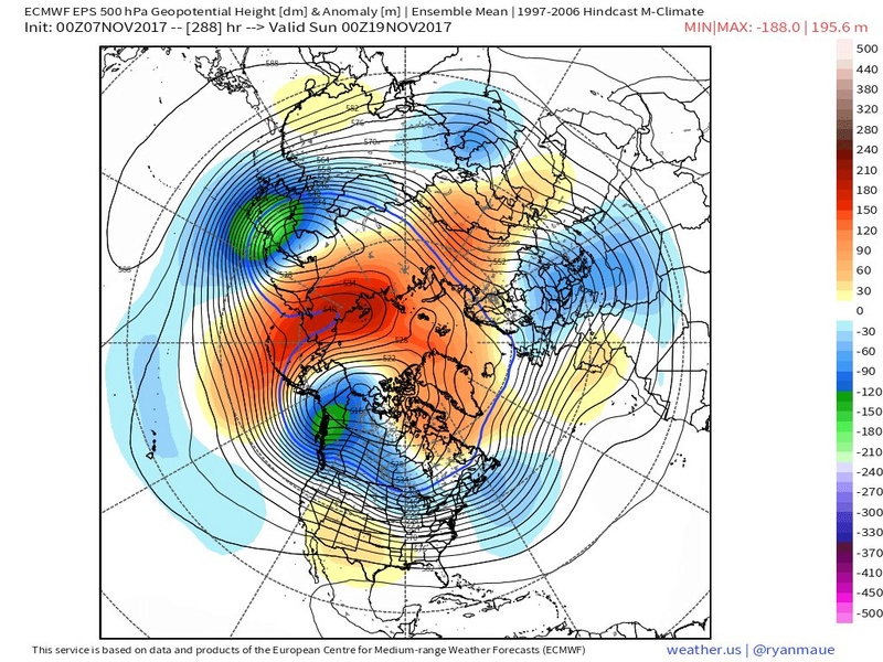
![]() by amugs Tue Nov 07, 2017 1:09 pm
by amugs Tue Nov 07, 2017 1:09 pm
That block is sick, talk about over the top YIKEESS!!
Bring it big momma!!
_________________
Mugs
AKA:King: Snow Weenie
Self Proclaimed
WINTER 2014-15 : 55.12" +.02 for 6 coatings (avg. 35")
WINTER 2015-16 Total - 29.8" (Avg 35")
WINTER 2016-17 : 39.5" so far
amugs- Advanced Forecaster - Mod
- Posts : 15093
Reputation : 213
Join date : 2013-01-07
Age : 54
Location : Hillsdale,NJ
Page 5 of 42 • 1, 2, 3, 4, 5, 6 ... 23 ... 42 ![]()
|
|
|