
 Search
March 7th Godzilla: 1st Call Snow Map
Page 13 of 24 •  1 ... 8 ... 12, 13, 14 ... 18 ... 24
 ![]()
Re: March 7th Godzilla: 1st Call Snow Map
![]() by sroc4 Tue Mar 06, 2018 1:01 pm
by sroc4 Tue Mar 06, 2018 1:01 pm
Last edited by sroc4 on Tue Mar 06, 2018 1:02 pm; edited 1 time in total
sroc4- Admin

- Posts : 8331
Join date : 2013-01-07
Re: March 7th Godzilla: 1st Call Snow Map
![]() by devsman Tue Mar 06, 2018 1:01 pm
by devsman Tue Mar 06, 2018 1:01 pm
devsman- Pro Enthusiast

- Posts : 424
Join date : 2014-01-01
Re: March 7th Godzilla: 1st Call Snow Map
![]() by mikeypizano Tue Mar 06, 2018 1:02 pm
by mikeypizano Tue Mar 06, 2018 1:02 pm

mikeypizano- Pro Enthusiast
- Posts : 1118
Reputation : 66
Join date : 2017-01-05
Age : 35
Location : Wilkes-Barre/Scranton, PA
Re: March 7th Godzilla: 1st Call Snow Map
![]() by SoulSingMG Tue Mar 06, 2018 1:02 pm
by SoulSingMG Tue Mar 06, 2018 1:02 pm
RJB8525 wrote:

Haha this made me LOL

SoulSingMG- Senior Enthusiast

- Posts : 2853
Reputation : 74
Join date : 2013-12-11
Location : Long Island City, NY
Re: March 7th Godzilla: 1st Call Snow Map
![]() by Frank_Wx Tue Mar 06, 2018 1:02 pm
by Frank_Wx Tue Mar 06, 2018 1:02 pm

_________________
_______________________________________________________________________________________________________
CLICK HERE to view NJ Strong Snowstorm Classifications

Frank_Wx- Godzilla Seeker
- Posts : 21305
Reputation : 328
Join date : 2013-01-05
Age : 31
Location : Jersey City, NJ -

Re: March 7th Godzilla: 1st Call Snow Map
![]() by sroc4 Tue Mar 06, 2018 1:03 pm
by sroc4 Tue Mar 06, 2018 1:03 pm
Frank_Wx wrote:
Your killing me with this map. What about the eastern half of our sites coverage?
_________________
"In weather and in life, there's no winning and losing; there's only winning and learning."
WINTER 2012/2013 TOTALS 43.65"WINTER 2017/2018 TOTALS 62.85" WINTER 2022/2023 TOTALS 4.9"
WINTER 2013/2014 TOTALS 64.85"WINTER 2018/2019 TOTALS 14.25" WINTER 2023/2024 TOTALS 13.1"
WINTER 2014/2015 TOTALS 71.20"WINTER 2019/2020 TOTALS 6.35"
WINTER 2015/2016 TOTALS 35.00"WINTER 2020/2021 TOTALS 37.75"
WINTER 2016/2017 TOTALS 42.25"WINTER 2021/2022 TOTALS 31.65"

sroc4- Admin
- Posts : 8331
Reputation : 301
Join date : 2013-01-07
Location : Wading River, LI
Re: March 7th Godzilla: 1st Call Snow Map
![]() by Frank_Wx Tue Mar 06, 2018 1:04 pm
by Frank_Wx Tue Mar 06, 2018 1:04 pm
_________________
_______________________________________________________________________________________________________
CLICK HERE to view NJ Strong Snowstorm Classifications
Frank_Wx- Godzilla Seeker
- Posts : 21305
Reputation : 328
Join date : 2013-01-05
Age : 31
Location : Jersey City, NJ -
Re: March 7th Godzilla: 1st Call Snow Map
![]() by rb924119 Tue Mar 06, 2018 1:05 pm
by rb924119 Tue Mar 06, 2018 1:05 pm
sroc4 wrote:Frank_Wx wrote:
Your killing me with this map. What about the eastern half of our sites coverage?
Rain

rb924119- Meteorologist

- Posts : 6889
Reputation : 194
Join date : 2013-02-06
Age : 32
Location : Greentown, Pa
Re: March 7th Godzilla: 1st Call Snow Map
![]() by jimv45 Tue Mar 06, 2018 1:08 pm
by jimv45 Tue Mar 06, 2018 1:08 pm
jimv45- Senior Enthusiast
- Posts : 1168
Reputation : 36
Join date : 2013-09-20
Location : Hopewell jct.
Re: March 7th Godzilla: 1st Call Snow Map
![]() by rb924119 Tue Mar 06, 2018 1:10 pm
by rb924119 Tue Mar 06, 2018 1:10 pm
jimv45 wrote:Rb think were in a good spot with this one? Last one was just heavy slop.
Affirmative. No slop up here lmao
rb924119- Meteorologist
- Posts : 6889
Reputation : 194
Join date : 2013-02-06
Age : 32
Location : Greentown, Pa
Re: March 7th Godzilla: 1st Call Snow Map
![]() by jimv45 Tue Mar 06, 2018 1:14 pm
by jimv45 Tue Mar 06, 2018 1:14 pm
jimv45- Senior Enthusiast
- Posts : 1168
Reputation : 36
Join date : 2013-09-20
Location : Hopewell jct.
Re: March 7th Godzilla: 1st Call Snow Map
![]() by rb924119 Tue Mar 06, 2018 1:17 pm
by rb924119 Tue Mar 06, 2018 1:17 pm
jimv45 wrote:Good just got my family another Husky and this will be her first snow with us.
D'aweeeeeeeeeeeeeeeeeeeeeeeeeee :')
rb924119- Meteorologist
- Posts : 6889
Reputation : 194
Join date : 2013-02-06
Age : 32
Location : Greentown, Pa
Re: March 7th Godzilla: 1st Call Snow Map
![]() by Frank_Wx Tue Mar 06, 2018 1:23 pm
by Frank_Wx Tue Mar 06, 2018 1:23 pm

_________________
_______________________________________________________________________________________________________
CLICK HERE to view NJ Strong Snowstorm Classifications
Frank_Wx- Godzilla Seeker
- Posts : 21305
Reputation : 328
Join date : 2013-01-05
Age : 31
Location : Jersey City, NJ -
Re: March 7th Godzilla: 1st Call Snow Map
![]() by sroc4 Tue Mar 06, 2018 1:27 pm
by sroc4 Tue Mar 06, 2018 1:27 pm
Then 6 hrs later H5 closes off and the surface Low has already been pulled underneath it? Im not buying it.

6 hrs after that the LP center jumps nearly due east while still strengthening and the CCB jumps from over the NYC metro area and points well west to all of a sudden well N&E over Red Sox Suck? In theory if that were correct the LP should be occluding by hr 36-42 therefore weakening; not strengthening. Personally I'm not buying the track of the main low. I think the euro was focusing precip around the wrong Low and the track will be east of what it showed..not by a whole lot but not like it showed.

_________________
"In weather and in life, there's no winning and losing; there's only winning and learning."
WINTER 2012/2013 TOTALS 43.65"WINTER 2017/2018 TOTALS 62.85" WINTER 2022/2023 TOTALS 4.9"
WINTER 2013/2014 TOTALS 64.85"WINTER 2018/2019 TOTALS 14.25" WINTER 2023/2024 TOTALS 13.1"
WINTER 2014/2015 TOTALS 71.20"WINTER 2019/2020 TOTALS 6.35"
WINTER 2015/2016 TOTALS 35.00"WINTER 2020/2021 TOTALS 37.75"
WINTER 2016/2017 TOTALS 42.25"WINTER 2021/2022 TOTALS 31.65"
sroc4- Admin
- Posts : 8331
Reputation : 301
Join date : 2013-01-07
Location : Wading River, LI
Re: March 7th Godzilla: 1st Call Snow Map
![]() by Smittyaj623 Tue Mar 06, 2018 1:33 pm
by Smittyaj623 Tue Mar 06, 2018 1:33 pm
Smittyaj623- Posts : 73
Reputation : 6
Join date : 2018-03-06
Age : 23
Location : Bayville, NJ
Re: March 7th Godzilla: 1st Call Snow Map
![]() by SoulSingMG Tue Mar 06, 2018 1:35 pm
by SoulSingMG Tue Mar 06, 2018 1:35 pm
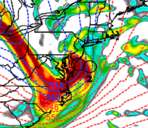
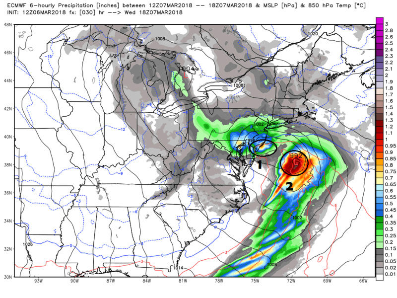
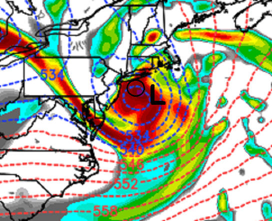
sroc4 wrote:I have a question Ray or Frank. Looking at the surface and 500mb between hr 30-36...that's when we close off H5 south of LI. But notice in the first images we have a dual low but H5 is not closed off yet. Just looking at this the euro looks to me to be focusing on the Low along the coast when in reality the best PVA looks to be with the low further off the coast.
Then 6 hrs later H5 closes off and the surface Low has already been pulled underneath it? Im not buying it.
6 hrs after that the LP center jumps nearly due east while still strengthening and the CCB jumps from over the NYC metro area and points well west to all of a sudden well N&E over Red Sox Suck? In theory if that were correct the LP should be occluding by hr 36-42 therefore weakening; not strengthening. Personally I'm not buying the track of the main low. I think the euro was focusing precip around the wrong Low and the track will be east of what it showed..not by a whole lot but not like it showed.
This
Last edited by SoulSingMG on Tue Mar 06, 2018 1:40 pm; edited 1 time in total
SoulSingMG- Senior Enthusiast
- Posts : 2853
Reputation : 74
Join date : 2013-12-11
Location : Long Island City, NY
Re: March 7th Godzilla: 1st Call Snow Map
![]() by sroc4 Tue Mar 06, 2018 1:39 pm
by sroc4 Tue Mar 06, 2018 1:39 pm
_________________
"In weather and in life, there's no winning and losing; there's only winning and learning."
WINTER 2012/2013 TOTALS 43.65"WINTER 2017/2018 TOTALS 62.85" WINTER 2022/2023 TOTALS 4.9"
WINTER 2013/2014 TOTALS 64.85"WINTER 2018/2019 TOTALS 14.25" WINTER 2023/2024 TOTALS 13.1"
WINTER 2014/2015 TOTALS 71.20"WINTER 2019/2020 TOTALS 6.35"
WINTER 2015/2016 TOTALS 35.00"WINTER 2020/2021 TOTALS 37.75"
WINTER 2016/2017 TOTALS 42.25"WINTER 2021/2022 TOTALS 31.65"
sroc4- Admin
- Posts : 8331
Reputation : 301
Join date : 2013-01-07
Location : Wading River, LI
Re: March 7th Godzilla: 1st Call Snow Map
![]() by rb924119 Tue Mar 06, 2018 1:40 pm
by rb924119 Tue Mar 06, 2018 1:40 pm
rb924119- Meteorologist
- Posts : 6889
Reputation : 194
Join date : 2013-02-06
Age : 32
Location : Greentown, Pa
Re: March 7th Godzilla: 1st Call Snow Map
![]() by SoulSingMG Tue Mar 06, 2018 1:45 pm
by SoulSingMG Tue Mar 06, 2018 1:45 pm
sroc4 wrote:Who is cranky guy? You post it but I never go to his site. Whats his name?
Honestly, I have no clue what his real name is. No one does. Lol. But he's the most accurate MET I've seen and MANY reference him. His posts on Twitter are super educational along with his storm entries. Click link below.
http://www.stormhamster.com/entry/e030518.htm
Last edited by SoulSingMG on Tue Mar 06, 2018 1:46 pm; edited 1 time in total
SoulSingMG- Senior Enthusiast
- Posts : 2853
Reputation : 74
Join date : 2013-12-11
Location : Long Island City, NY
Re: March 7th Godzilla: 1st Call Snow Map
![]() by nutleyblizzard Tue Mar 06, 2018 1:46 pm
by nutleyblizzard Tue Mar 06, 2018 1:46 pm
Great analysis. EURO should of ended up more east resulting in a snow map similar to the 0z run. In reality it doesn't matter anymore. Its now down to the short range models and current map observations from here on out. I'm very confident with 8-12+ amounts west of Hudson River. NYC in the 6-12 range.SoulSingMG wrote:sroc4 wrote:I have a question Ray or Frank. Looking at the surface and 500mb between hr 30-36...that's when we close off H5 south of LI. But notice in the first images we have a dual low but H5 is not closed off yet. Just looking at this the euro looks to me to be focusing on the Low along the coast when in reality the best PVA looks to be with the low further off the coast.
Then 6 hrs later H5 closes off and the surface Low has already been pulled underneath it? Im not buying it.
6 hrs after that the LP center jumps nearly due east while still strengthening and the CCB jumps from over the NYC metro area and points well west to all of a sudden well N&E over Red Sox Suck? In theory if that were correct the LP should be occluding by hr 36-42 therefore weakening; not strengthening. Personally I'm not buying the track of the main low. I think the euro was focusing precip around the wrong Low and the track will be east of what it showed..not by a whole lot but not like it showed.
This

nutleyblizzard- Senior Enthusiast
- Posts : 1952
Reputation : 41
Join date : 2014-01-30
Age : 58
Location : Nutley, new jersey
Re: March 7th Godzilla: 1st Call Snow Map
![]() by Blaze Tue Mar 06, 2018 1:53 pm
by Blaze Tue Mar 06, 2018 1:53 pm
Blaze- Posts : 21
Reputation : 5
Join date : 2018-03-06
Re: March 7th Godzilla: 1st Call Snow Map
![]() by SoulSingMG Tue Mar 06, 2018 2:03 pm
by SoulSingMG Tue Mar 06, 2018 2:03 pm
SoulSingMG- Senior Enthusiast
- Posts : 2853
Reputation : 74
Join date : 2013-12-11
Location : Long Island City, NY
Re: March 7th Godzilla: 1st Call Snow Map
![]() by mikeypizano Tue Mar 06, 2018 2:05 pm
by mikeypizano Tue Mar 06, 2018 2:05 pm
SoulSingMG wrote:State of Emergency declared for New Jersey.
Knowing PA, we won't have one...
mikeypizano- Pro Enthusiast
- Posts : 1118
Reputation : 66
Join date : 2017-01-05
Age : 35
Location : Wilkes-Barre/Scranton, PA
Re: March 7th Godzilla: 1st Call Snow Map
![]() by Carter bk Tue Mar 06, 2018 2:05 pm
by Carter bk Tue Mar 06, 2018 2:05 pm
Carter bk- Posts : 73
Reputation : 5
Join date : 2017-12-07
Re: March 7th Godzilla: 1st Call Snow Map
![]() by RJB8525 Tue Mar 06, 2018 2:07 pm
by RJB8525 Tue Mar 06, 2018 2:07 pm
mikeypizano wrote:SoulSingMG wrote:State of Emergency declared for New Jersey.
Knowing PA, we won't have one...
and school will be open lol

RJB8525- Senior Enthusiast
- Posts : 1994
Reputation : 28
Join date : 2013-02-06
Age : 38
Location : Hackettstown, NJ
Re: March 7th Godzilla: 1st Call Snow Map
![]() by DAYBLAZER Tue Mar 06, 2018 2:08 pm
by DAYBLAZER Tue Mar 06, 2018 2:08 pm
Frank_Wx wrote:
My god it's jackpotting right over my town. We CANNOT have this happen, this area will be devastated....

DAYBLAZER- Posts : 228
Reputation : 20
Join date : 2017-03-12
Location : Hopatcong, NJ Sussex County
Page 13 of 24 • 1 ... 8 ... 12, 13, 14 ... 18 ... 24 ![]()