
 Search
Long Range Thread 17.0
Page 8 of 41 •  1 ... 5 ... 7, 8, 9 ... 24 ... 41
 ![]()
Re: Long Range Thread 17.0
![]() by algae888 Wed Nov 07, 2018 6:51 am
by algae888 Wed Nov 07, 2018 6:51 am
algae888- Advanced Forecaster

- Posts : 5311
Join date : 2013-02-05
Re: Long Range Thread 17.0
![]() by algae888 Wed Nov 07, 2018 11:35 am
by algae888 Wed Nov 07, 2018 11:35 am
algae888- Advanced Forecaster
- Posts : 5311
Join date : 2013-02-05
Re: Long Range Thread 17.0
![]() by amugs Wed Nov 07, 2018 8:05 pm
by amugs Wed Nov 07, 2018 8:05 pm
Nsfxwx compliment's for these

_________________
Mugs
AKA:King: Snow Weenie
Self Proclaimed
WINTER 2014-15 : 55.12" +.02 for 6 coatings (avg. 35")
WINTER 2015-16 Total - 29.8" (Avg 35")
WINTER 2016-17 : 39.5" so far

amugs- Advanced Forecaster - Mod

- Posts : 15093
Reputation : 213
Join date : 2013-01-07
Age : 54
Location : Hillsdale,NJ
Re: Long Range Thread 17.0
![]() by amugs Wed Nov 07, 2018 8:10 pm
by amugs Wed Nov 07, 2018 8:10 pm
Wow but we'll see, still think W Bergen County N&W sees snows and the coastal plain sees wet snow flakes at this time.
https://twitter.com/NsfwWx/status/1060332550101581829?s=19
_________________
Mugs
AKA:King: Snow Weenie
Self Proclaimed
WINTER 2014-15 : 55.12" +.02 for 6 coatings (avg. 35")
WINTER 2015-16 Total - 29.8" (Avg 35")
WINTER 2016-17 : 39.5" so far
amugs- Advanced Forecaster - Mod
- Posts : 15093
Reputation : 213
Join date : 2013-01-07
Age : 54
Location : Hillsdale,NJ
Re: Long Range Thread 17.0
![]() by dkodgis Wed Nov 07, 2018 8:13 pm
by dkodgis Wed Nov 07, 2018 8:13 pm
Me too.
Doc, maybe.

dkodgis- Senior Enthusiast

- Posts : 2493
Reputation : 98
Join date : 2013-12-29
Re: Long Range Thread 17.0
![]() by docstox12 Thu Nov 08, 2018 5:31 am
by docstox12 Thu Nov 08, 2018 5:31 am
dkodgis wrote:CP is standing on his deck right now, looking Northwest.
Me too.
Doc, maybe.
Yesterday, the look was better, but as of this morning, NWS has removed any mention of snow with the rains coming in next week.

docstox12- Wx Statistician Guru

- Posts : 8502
Reputation : 222
Join date : 2013-01-07
Age : 73
Location : Monroe NY
Re: Long Range Thread 17.0
![]() by sroc4 Thu Nov 08, 2018 12:35 pm
by sroc4 Thu Nov 08, 2018 12:35 pm


_________________
"In weather and in life, there's no winning and losing; there's only winning and learning."
WINTER 2012/2013 TOTALS 43.65"WINTER 2017/2018 TOTALS 62.85" WINTER 2022/2023 TOTALS 4.9"
WINTER 2013/2014 TOTALS 64.85"WINTER 2018/2019 TOTALS 14.25" WINTER 2023/2024 TOTALS 13.1"
WINTER 2014/2015 TOTALS 71.20"WINTER 2019/2020 TOTALS 6.35"
WINTER 2015/2016 TOTALS 35.00"WINTER 2020/2021 TOTALS 37.75"
WINTER 2016/2017 TOTALS 42.25"WINTER 2021/2022 TOTALS 31.65"

sroc4- Admin

- Posts : 8331
Reputation : 301
Join date : 2013-01-07
Location : Wading River, LI

billg315- Advanced Forecaster - Mod
- Posts : 4462
Reputation : 185
Join date : 2015-01-24
Age : 50
Location : Flemington, NJ
Re: Long Range Thread 17.0
![]() by Dunnzoo Thu Nov 08, 2018 8:14 pm
by Dunnzoo Thu Nov 08, 2018 8:14 pm
_________________
Janet
Snowfall winter of 2023-2024 17.5"
Snowfall winter of 2022-2023 6.0"
Snowfall winter of 2021-2022 17.6" 1" sleet 2/25/22
Snowfall winter of 2020-2021 51.1"
Snowfall winter of 2019-2020 8.5"
Snowfall winter of 2018-2019 25.1"
Snowfall winter of 2017-2018 51.9"
Snowfall winter of 2016-2017 45.6"
Snowfall winter of 2015-2016 29.5"
Snowfall winter of 2014-2015 50.55"
Snowfall winter of 2013-2014 66.5"

Dunnzoo- Senior Enthusiast - Mod
- Posts : 4884
Reputation : 68
Join date : 2013-01-11
Age : 62
Location : Westwood, NJ
Re: Long Range Thread 17.0
![]() by docstox12 Fri Nov 09, 2018 5:33 am
by docstox12 Fri Nov 09, 2018 5:33 am
docstox12- Wx Statistician Guru
- Posts : 8502
Reputation : 222
Join date : 2013-01-07
Age : 73
Location : Monroe NY
Re: Long Range Thread 17.0
![]() by rb924119 Fri Nov 09, 2018 6:07 am
by rb924119 Fri Nov 09, 2018 6:07 am
“In my opinion, the potential (wintry) storm threat progged to impact our region early next week will come down to a battle between latent heat release versus the anomalous snowpack/positive feedback trend occurring in Canada in recent weeks, as has been discussed ad nauseum by *******. My reason comes from the fact that there is a complete Northern Hemispheric incongruency amongst major features that are all negatively interfering with each other. For example, whilenwe will have a -NAO to work with, we are lacking the presence of a true 50/50 low, which is a combination I like to see. Similarly, while we have a great -EPO signal, we are lacking a -AO. Third, our +PNA ridge spike (a dime-piece look of one, I might add) is likely to be offset by the presence of a sustained SOI spike in recent days passed. In addition to all of that, the signal of a -WPO will be countered by a Niño 1.2 spike in the final ten days of October. With the MJO likely to be a non-factor here (this is all in my opinion/analysis, of course), we have to look at things closer to home to try find any further clues.
In this case, the two factors come down to the two mentioned at the top, and while I fully agree with the sentiments regarding the Canadian feedbacks having a substantial impact on our sensible weather, especially down the road, I feel that it will be out-dueled by the latent heat release (this time). Why? Well, when you have such amplification with such large departures from normal in regions of their progression (i.e. a trough of this magnitude at this latitude) the results they produce are likely to follow suit. In regard to the trough in question, it will have quite a southerly fetch out ahead of it, and with such warmth in the Gulf and western Atlantic, I think that there will be a whole lot of precipitation and even thunderstorms across the Southeast. As a result, I feel the latent heat release in conjunction with sharp wavelengths of the amplified pattern will be enough to adequately raise heights ahead of our developing system, such that the steering flow will be corrected from the SSW instead of the SW. As such, while it will be a very near “miss” thermodynamically speaking, I expect the lower-level feature to pass either directly over our region, (just east of the Appalachian spine) or too close to our region to substantially override the warm advection aloft. I think we see one of those stereotypical cold, raw, nasty November rains. Quite possibly 33andrain for many lol just my opinion, and I can certainly see the other side of the argument, where it’s a very near “hit” thermodynamically, but favor the former as of now.”
rb924119- Meteorologist

- Posts : 6889
Reputation : 194
Join date : 2013-02-06
Age : 32
Location : Greentown, Pa
Re: Long Range Thread 17.0
![]() by Frank_Wx Fri Nov 09, 2018 9:14 am
by Frank_Wx Fri Nov 09, 2018 9:14 am
Right now it looks like next week, after Tuesday's storm, will be below normal then there will be a gradual warm-up into next weekend and the week of the 19th. The warm-up will only bring slightly above normal temperatures. Nothing too drastic because the -EPO will still feed cooler air from Canada down into the eastern CONUS.
_________________
_______________________________________________________________________________________________________
CLICK HERE to view NJ Strong Snowstorm Classifications

Frank_Wx- Godzilla Seeker
- Posts : 21305
Reputation : 328
Join date : 2013-01-05
Age : 31
Location : Jersey City, NJ -

Re: Long Range Thread 17.0
![]() by Frank_Wx Fri Nov 09, 2018 9:21 am
by Frank_Wx Fri Nov 09, 2018 9:21 am
The MJO is shown to be in phase 2 then going through phases 3-4-5. This is in line with what we're seeing on the VP200 maps, where blue color shows the tropical wave propagating eastward.
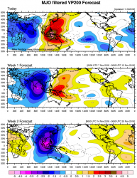
These phases typically lead to milder weather for the eastern U.S., and models do show a small warm-up the week of Thanksgiving. But if this tropical wave is as potent as some of these maps are showing it is possible the MJO enters phases 6-7-8 which would suggest a cold pattern to come late November / early December.
Still long ways off. We will see!
_________________
_______________________________________________________________________________________________________
CLICK HERE to view NJ Strong Snowstorm Classifications
Frank_Wx- Godzilla Seeker
- Posts : 21305
Reputation : 328
Join date : 2013-01-05
Age : 31
Location : Jersey City, NJ -
Re: Long Range Thread 17.0
![]() by skinsfan1177 Sat Nov 10, 2018 8:56 am
by skinsfan1177 Sat Nov 10, 2018 8:56 am

skinsfan1177- Senior Enthusiast
- Posts : 4485
Reputation : 35
Join date : 2013-01-07
Age : 46
Location : Point Pleasant Boro
Re: Long Range Thread 17.0
![]() by algae888 Sat Nov 10, 2018 11:32 am
by algae888 Sat Nov 10, 2018 11:32 am

algae888- Advanced Forecaster
- Posts : 5311
Reputation : 46
Join date : 2013-02-05
Age : 61
Location : mt. vernon, new york
Re: Long Range Thread 17.0
![]() by algae888 Sat Nov 10, 2018 2:45 pm
by algae888 Sat Nov 10, 2018 2:45 pm
algae888- Advanced Forecaster
- Posts : 5311
Reputation : 46
Join date : 2013-02-05
Age : 61
Location : mt. vernon, new york
Re: Long Range Thread 17.0
![]() by algae888 Sat Nov 10, 2018 6:29 pm
by algae888 Sat Nov 10, 2018 6:29 pm
algae888- Advanced Forecaster
- Posts : 5311
Reputation : 46
Join date : 2013-02-05
Age : 61
Location : mt. vernon, new york
Re: Long Range Thread 17.0
![]() by docstox12 Sun Nov 11, 2018 6:31 am
by docstox12 Sun Nov 11, 2018 6:31 am
algae888 wrote:It looks like we have one Coastal low after another on the latest models from today's 12z runs once these patterns lock in it's hard to break them down what's very encouraging is the very active subtropical jet hopefully and most likely it will remain through winter National Weather Service disco has the mention of snow for the area next weekend
One coastal low after another reminds me of the 1995-1996 pattern.That one locked in for constant snowstorms.
docstox12- Wx Statistician Guru
- Posts : 8502
Reputation : 222
Join date : 2013-01-07
Age : 73
Location : Monroe NY
Re: Long Range Thread 17.0
![]() by algae888 Sun Nov 11, 2018 7:30 am
by algae888 Sun Nov 11, 2018 7:30 am
algae888- Advanced Forecaster
- Posts : 5311
Reputation : 46
Join date : 2013-02-05
Age : 61
Location : mt. vernon, new york
Re: Long Range Thread 17.0
![]() by nutleyblizzard Sun Nov 11, 2018 7:55 am
by nutleyblizzard Sun Nov 11, 2018 7:55 am
Starting to get excited as we get closer to the start of meteorological winter which begins on December 1st. We have a textbook southern jet which exits the GOM and rides up the eastern seaboard. The MJO looks to remain in favorable 8-1-2 mode for the majority of winter with only brief warmups being felt as per the colder waters being seen in the Indian ocean. That equates to frequent winter storms for us as well as our mid Atlantic and New England neighbors. The only question remains is how much of a -NAO do we see? That will be the determining factor between moderate and major events. There's no doubt we will rival 95-96 with blocking in place.docstox12 wrote:algae888 wrote:It looks like we have one Coastal low after another on the latest models from today's 12z runs once these patterns lock in it's hard to break them down what's very encouraging is the very active subtropical jet hopefully and most likely it will remain through winter National Weather Service disco has the mention of snow for the area next weekend
One coastal low after another reminds me of the 1995-1996 pattern.That one locked in for constant snowstorms.

nutleyblizzard- Senior Enthusiast
- Posts : 1952
Reputation : 41
Join date : 2014-01-30
Age : 58
Location : Nutley, new jersey
Re: Long Range Thread 17.0
![]() by sroc4 Sun Nov 11, 2018 9:16 am
by sroc4 Sun Nov 11, 2018 9:16 am
algae888 wrote:Okay boys and girls first legit snow chance next week Thursday night and Friday all models have snow for parts of our area from a coastal low that develops from leftover energy from Tuesday storm still have a lot of things to iron out especially track of the low and where high pressure sets up is it over Maine or does it move East off the coastal Waters that would have big implications on whether we keep the cold air locked in or we get a warm easterly fetch off the water the former would mean snow for a good part of our area the latter snow for the interior and yes doc it reminds me of 95-96 and I believe that year had storm after storm in November also very wet pattern I like the similarities
Im extremely hesitant to get my hopes up on this threat for anyone other than The Aresian….for now. Yes some higher elevations may see some flakes fly but as true threat for sig accum for the vast majority of this board coverage area...again im extremely hesitant..at this time
_________________
"In weather and in life, there's no winning and losing; there's only winning and learning."
WINTER 2012/2013 TOTALS 43.65"WINTER 2017/2018 TOTALS 62.85" WINTER 2022/2023 TOTALS 4.9"
WINTER 2013/2014 TOTALS 64.85"WINTER 2018/2019 TOTALS 14.25" WINTER 2023/2024 TOTALS 13.1"
WINTER 2014/2015 TOTALS 71.20"WINTER 2019/2020 TOTALS 6.35"
WINTER 2015/2016 TOTALS 35.00"WINTER 2020/2021 TOTALS 37.75"
WINTER 2016/2017 TOTALS 42.25"WINTER 2021/2022 TOTALS 31.65"
sroc4- Admin
- Posts : 8331
Reputation : 301
Join date : 2013-01-07
Location : Wading River, LI
Re: Long Range Thread 17.0
![]() by Guest Sun Nov 11, 2018 9:27 am
by Guest Sun Nov 11, 2018 9:27 am
Guest- Guest
Re: Long Range Thread 17.0
![]() by Guest Sun Nov 11, 2018 9:50 am
by Guest Sun Nov 11, 2018 9:50 am
sroc4 wrote:algae888 wrote:Okay boys and girls first legit snow chance next week Thursday night and Friday all models have snow for parts of our area from a coastal low that develops from leftover energy from Tuesday storm still have a lot of things to iron out especially track of the low and where high pressure sets up is it over Maine or does it move East off the coastal Waters that would have big implications on whether we keep the cold air locked in or we get a warm easterly fetch off the water the former would mean snow for a good part of our area the latter snow for the interior and yes doc it reminds me of 95-96 and I believe that year had storm after storm in November also very wet pattern I like the similarities
Im extremely hesitant to get my hopes up on this threat for anyone other than The Aresian….for now. Yes some higher elevations may see some flakes fly but as true threat for sig accum for the vast majority of this board coverage area...again im extremely hesitant..at this time
I'm always hesitant to get my hopes up for significant snow. If memory serves, the geography of my area helps lead to the energy transfer that creates Miller B systems. (I'm probably wrong here, but I think it involves vertical stacking). As for the coastal systems, I'm too far inland the vast majority of the time. A storm that drops 6-8 here is considered huge.
Guest- Guest
Re: Long Range Thread 17.0
![]() by algae888 Sun Nov 11, 2018 10:34 am
by algae888 Sun Nov 11, 2018 10:34 am
Ya scott extremely hard to get snow in our area in November with that said however we're going to have an anomalously cold air mass in place temps can get down as cold as 20in are northwest suburbs and below freezing at the coast Thursday morning I would not look for an all out snow storm but snow to rain event is quite possible with some small accumulations even down to the coast. Das German says yes and so do many GEFS members also the Euro had small accumulation for our area although it was slower. we need moisture to quickly come in behind this cold snapsroc4 wrote:algae888 wrote:Okay boys and girls first legit snow chance next week Thursday night and Friday all models have snow for parts of our area from a coastal low that develops from leftover energy from Tuesday storm still have a lot of things to iron out especially track of the low and where high pressure sets up is it over Maine or does it move East off the coastal Waters that would have big implications on whether we keep the cold air locked in or we get a warm easterly fetch off the water the former would mean snow for a good part of our area the latter snow for the interior and yes doc it reminds me of 95-96 and I believe that year had storm after storm in November also very wet pattern I like the similarities
Im extremely hesitant to get my hopes up on this threat for anyone other than The Aresian….for now. Yes some higher elevations may see some flakes fly but as true threat for sig accum for the vast majority of this board coverage area...again im extremely hesitant..at this time
algae888- Advanced Forecaster
- Posts : 5311
Reputation : 46
Join date : 2013-02-05
Age : 61
Location : mt. vernon, new york
Re: Long Range Thread 17.0
![]() by frank 638 Sun Nov 11, 2018 11:32 am
by frank 638 Sun Nov 11, 2018 11:32 am
frank 638- Senior Enthusiast
- Posts : 2824
Reputation : 37
Join date : 2016-01-01
Age : 40
Location : bronx ny
Re: Long Range Thread 17.0
![]() by algae888 Sun Nov 11, 2018 2:33 pm
by algae888 Sun Nov 11, 2018 2:33 pm
algae888- Advanced Forecaster
- Posts : 5311
Reputation : 46
Join date : 2013-02-05
Age : 61
Location : mt. vernon, new york
Re: Long Range Thread 17.0
![]() by amugs Sun Nov 11, 2018 4:39 pm
by amugs Sun Nov 11, 2018 4:39 pm
algae888 wrote:Today's euro is 4 to 8 in for Orange County and Northwest New Jersey Thursday night into Friday morning 1 to 3 in I 287 up to the Orange County Line nothing at the coast. Still optimistic we'll see our first flakes from this system we shall see
For teh coastal plain and LI they may see a mix but its mostly rain. Don't underestimate teh CAD signature and that these Southern Storms have come in faster the progged even by a few hours it would be a huge difference in the Ptypes.
_________________
Mugs
AKA:King: Snow Weenie
Self Proclaimed
WINTER 2014-15 : 55.12" +.02 for 6 coatings (avg. 35")
WINTER 2015-16 Total - 29.8" (Avg 35")
WINTER 2016-17 : 39.5" so far
amugs- Advanced Forecaster - Mod
- Posts : 15093
Reputation : 213
Join date : 2013-01-07
Age : 54
Location : Hillsdale,NJ
Page 8 of 41 • 1 ... 5 ... 7, 8, 9 ... 24 ... 41 ![]()
|
|
|