Long Range Thread 17.0
+40
Radz
lglickman1
Wheezer
aiannone
heehaw453
SENJsnowman
Scullybutcher
jake732
Sanchize06
larryrock72
bobjohnsonforthehall
SnowForest
hyde345
SoulSingMG
weatherwatchermom
MattyICE
GreyBeard
Smittyaj623
HectorO
Vinnydula
Nyi1058
jmanley32
CPcantmeasuresnow
Dunnzoo
algae888
skinsfan1177
Snow88
Quietace
rb924119
dkodgis
sroc4
docstox12
Grselig
amugs
Math23x7
billg315
nutleyblizzard
frank 638
mwilli5783
Frank_Wx
44 posters
Page 33 of 41
Page 33 of 41 •  1 ... 18 ... 32, 33, 34 ... 37 ... 41
 Re: Long Range Thread 17.0
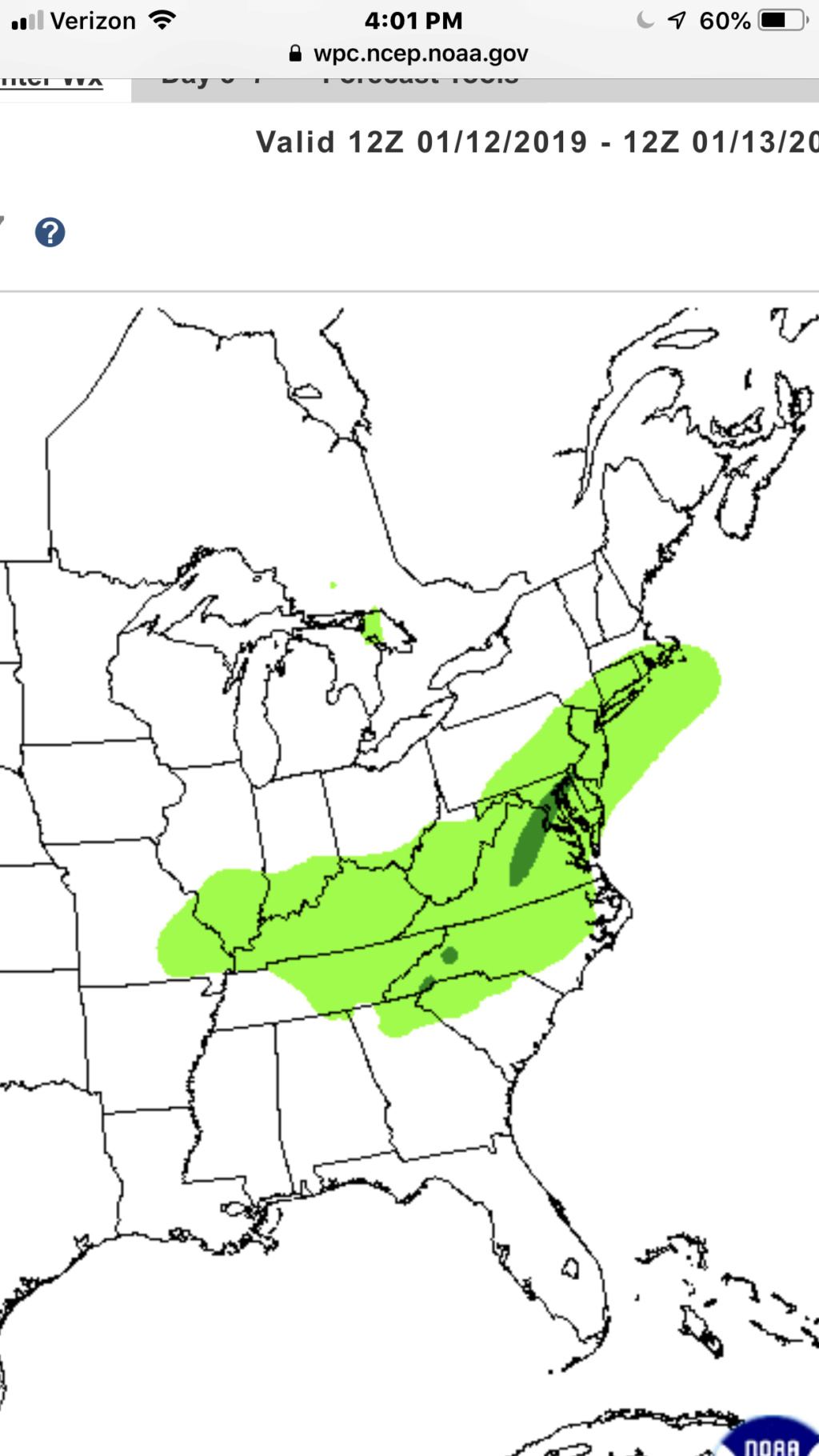
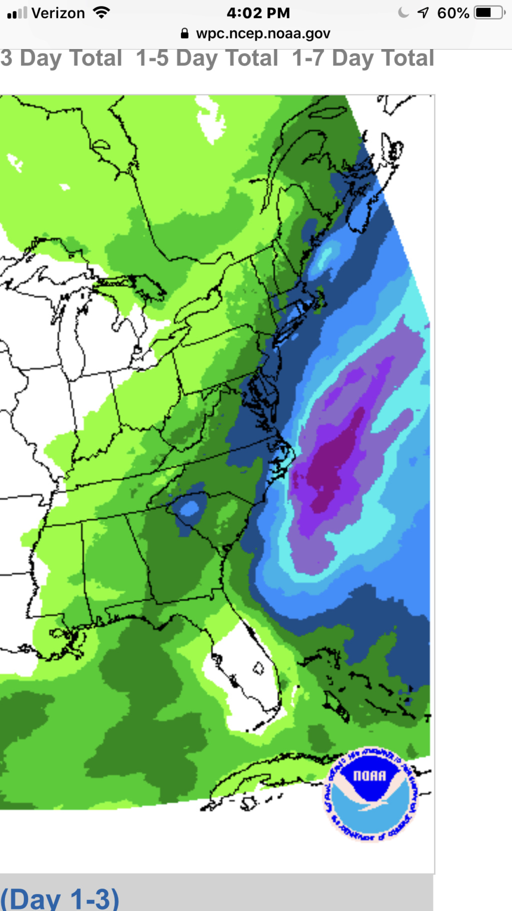
rb really?? The evolution of the upper atmospheric pattern is ripening for a high ceiling event - curious as to you reasoning.
The ridge out west is being pumped - is this what you are disagreeing with?
I have to say I wish it were Friday 12z or even Saturday than Monday - my one concern.
This is beautiful though:

The ridge out west is being pumped - is this what you are disagreeing with?
I have to say I wish it were Friday 12z or even Saturday than Monday - my one concern.
This is beautiful though:

amugs- Advanced Forecaster - Mod

- Posts : 15093
Join date : 2013-01-07
 Re: Long Range Thread 17.0
The 12z Gfs shows motherazilla to Godzilla potential. I'm hopeful but tempering expectations.
jmanley32- Senior Enthusiast

- Posts : 20516
Join date : 2013-12-12
 Re: Long Range Thread 17.0
Suppression from the North keeping the storm too far to the South (ala the December miss) seems like the issue of biggest concern. Along with any issues with the ridge going forward.

bobjohnsonforthehall- Posts : 311
Reputation : 19
Join date : 2016-10-02
Location : Flemington NJ
 Re: Long Range Thread 17.0
bobjohnsonforthehall wrote:Suppression from the North keeping the storm too far to the South (ala the December miss) seems like the issue of biggest concern. Along with any issues with the ridge going forward.
Yes, the northern stream energy can act as a "kicker" if it is too strong and refuses to phase with the southern energy. We really need that western ridge to phase that piece in. It would be a Godzilla event if it does.
_________________
_______________________________________________________________________________________________________
CLICK HERE to view NJ Strong Snowstorm Classifications
 Re: Long Range Thread 17.0
Hopefully this isn't too long or boring, but I hope that it helps illustrate my concerns for this system. As usual, any comments, questions, and/or concerns, please feel free to bring them up, and I'll do my best to answer them as able  Hope you all enjoy the read!
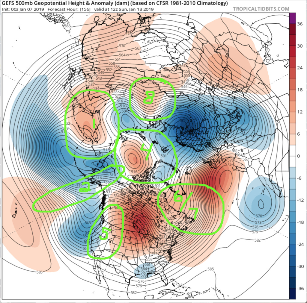
As mentioned last night, here is a brief discussion as to why I am not enthused with the system progged for the 13th. For reference, all reference to the Northern Hemisphere 500 hPa height anomalies will be based off of the 00z GFS Ensemble, which is, at the surface and on snowfall maps, the “most friendly” for the northern Mid-Atlantic and southern New England when compared to the Canadian/GEM and EURO suites. The map is a forecast valid for 12z, 13th January, which is when this ensemble depicts our system of interest coming into the Southeastern U.S., and a critical point in the overall synoptic evolution, as this is (geographically) where we like to see our systems “make the bend” or “turn the corner” and start a southwest-northeast trajectory. My analysis will be based on the 12-hour evolution starting from 00z, 13th January through the referenced image at 12z, 13th January., as that, to me, is the critical period for this event (based on this ensemble). Please note that this analysis is purely subjective and open for further discussion, and that all factors discussed are labeled in the images below for those who may not be as well-versed with some of the acronyms and where/what they are.
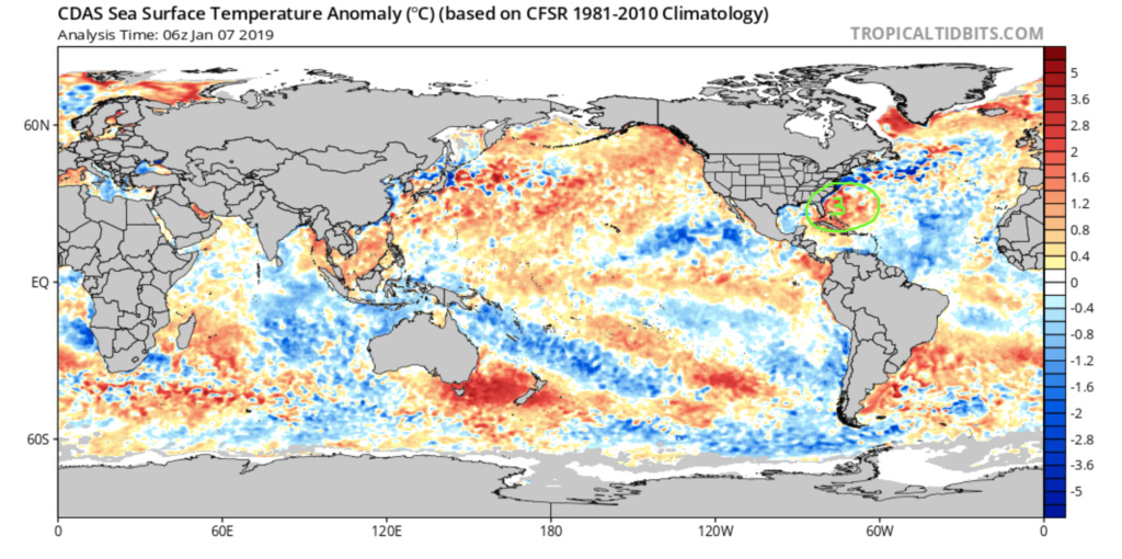
To start this discussion off, I would like to start with the factors that would allow height rises to ensue along the East Coast, of which there are three: 1. +W.P.O. 2. +E.P.O. (an argument could be made this is trending toward neutral, but I am considering it to be in a sensibly positive state here) 3. warm coastal waters off of the Southeastern U.S.. With the positive states of the two indices above, heights would naturally want to respond higher across the Eastern U.S. due to the associated flow regime, aided further by the warmth of the coastal waters around the Southeastern U.S. via surface latent heat flux. In regard to our current system of interest, this would be a counter to worries of suppression, as the baroclinic zone/storm track would develop further west and have more of a southerly component to it, as ridging would be enhanced across the East Coast and Western Atlantic domains. However, there is a plethora of other factors to be considered.
Moving into factors that I feel will have little impact there are the following: 4. neutral A.O. (yes, an argument could be made that this would be in a slightly negative phase, but as with the E.P.O., I am considering this to sensibly be neutral) 5. neutral P.N.A. (sensibly). Admittedly, this is probably going to be the single largest point of contention in this analysis, but I have reasons. I am considering the P.N.A. to be in a neutral state due to the overall pattern progression. Yes, as the southern stream system (our system of interest) is ejecting out of the Southwest, we have a truly positive P.N.A. ridge, with a classic axis location right through west-central Idaho, but as it begins to gain amplitude, it also begins shifting eastward on the heels of the southern stream system. By the time our system of interest reaches the Southeastern U.S., we have sensibly lost our P.N.A. ridge, even though the amplitude continues to build a bit further, as the axis is considerably further east, but do not yet have a negative phase, as mid-level energy/troughing has not yet overspread the region. This will be revisited shortly. An additional factor would be latent heat release from the precipitation processes associated with the system itself, as it draws moisture and heat fluxes from the Gulf during its progression eastward (diabatic latent heat release). In this case, though, I do not feel that will be enough of a factor to make any appreciable difference for two reasons: 1. the southern stream system itself is not very strong 2. the water in the Gulf is significantly cooler than normal, which will impart less heat energy, and therefore, less of an effect. An argument for the opposite case, where the negative anomalies would support the southern stream system remaining further south due to the lack of heat flux/negative temperature departure feedback would also be incorrect, in my opinion, given the warmth of the Caribbean and Southeastern U.S. coastal waters........the Gulf is not large enough to overpower that, and at best, may help to only partially offset that warmth. Similarly, due to the origin of our system and surface feature/flow, the warmth in those regional waters will not have an effect on the diabatic heat release initially, as they are too far south and east. If our system was going to be a true Miller-A, it would be a different story.
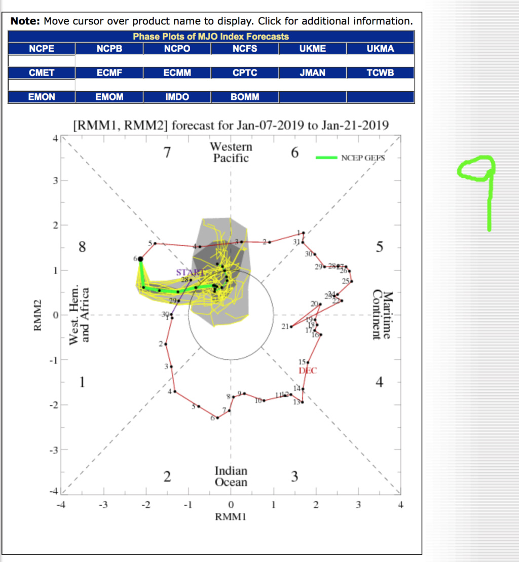
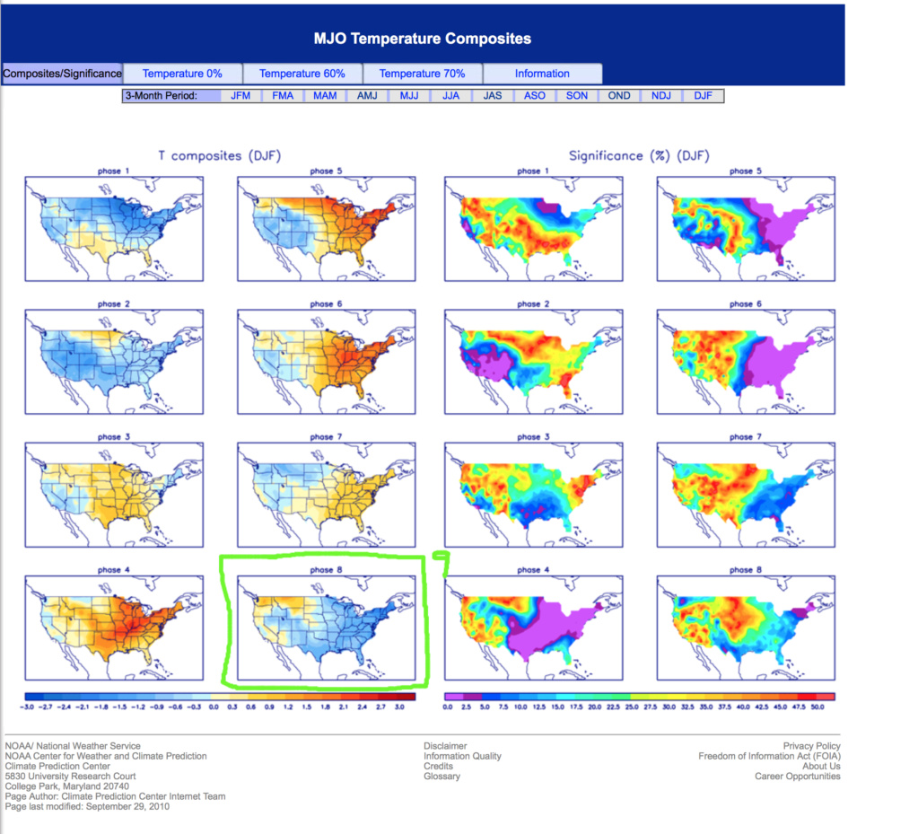
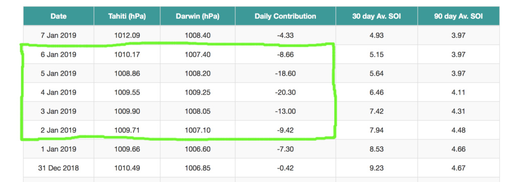
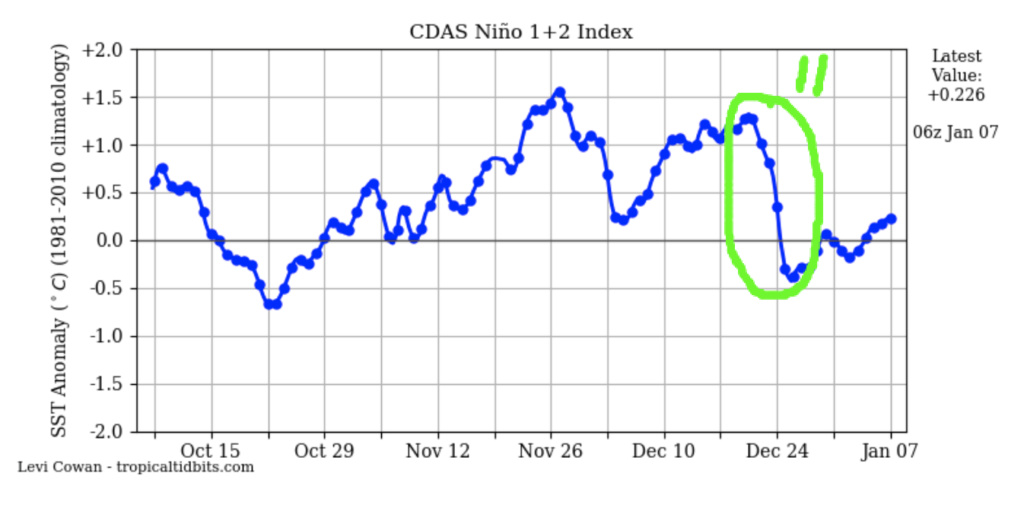
Lastly, here are the factors that would sensibly support enhanced troughing into the Eastern U.S., and therefore, a further southward baroclinic zone and associated storm track: 6. –N.A.O. 7. 50N/50E low 8. 70N/70E ridge 9. M.J.O. Phase 8 (or decayed Phase 8 into the Null Phase) 10. –S.O.I. spike (although relatively short-lived, I do think it will be enough to impart some effect, taking its known lag of seven to ten days into account) 11. rapid and substantial Niño 1.2 regional decline in S.S.T. anomalies (accounting for known lag of two to three weeks). Usually, these are all signs that we would look for to help our chances of seeing an East Coast snow storm; however, in this case, I think their combined effects will be too strong and substantially overcome the weak resistance from the +W.P.O./E.P.O. couplet and warm waters off the Southeastern U.S. Coast. The combined constructive feedback from these factors will work to keep the height field sufficiently suppressed along the East Coast such that the main storm track will remain more west-east than southwest-northeast, as we would typically like to see.
The evolution of the P.N.A. domain also further supports my argument. When looking at the 500 hPa anomaly map, notice where the largest positive height anomalies are as our system is traversing the Southeastern U.S. – Central Canada with very little height rebound across the Eastern U.S. and western Atlantic. Taking the factors and their impacts from the above paragraph into account, the strength and location of this anomalous ridging will work constructively to keep the storm’s evolution suppressed, in my opinion. There simply just isn’t enough of a height response out ahead of the system to allow a track up the coast far enough for the Northern Mid-Atlantic and Southern New England to capitalize. However, as with what happened in December, I think the Central and/or Southern Mid-Atlantic will capitalize with this system.


rb924119- Meteorologist

- Posts : 6890
Reputation : 194
Join date : 2013-02-06
Age : 32
Location : Greentown, Pa
 Re: Long Range Thread 17.0
bobjohnsonforthehall wrote:Suppression from the North keeping the storm too far to the South (ala the December miss) seems like the issue of biggest concern. Along with any issues with the ridge going forward.
NWS banking on this scenario
Guest- Guest
 Re: Long Range Thread 17.0
I’ve already written it off before I get emotionally invested. It’s the way I have to live this winter.

CPcantmeasuresnow- Wx Statistician Guru

- Posts : 7274
Reputation : 230
Join date : 2013-01-07
Age : 103
Location : Eastern Orange County, NY
 Re: Long Range Thread 17.0
CPcantmeasuresnow wrote:I’ve already written it off before I get emotionally invested. It’s the way I have to live this winter.
That's a good tactic CP until if and when the pattern shows some consistency for snow production.Since the November 15 11 inch storm in the HV, we are locked into a mild and rainy or a cold and suppression pattern.Disappointing to say the least.rb's long range analysis makes me think things won't get moving until the end of this month.Hoepfully, I am wrong.

docstox12- Wx Statistician Guru

- Posts : 8504
Reputation : 222
Join date : 2013-01-07
Age : 73
Location : Monroe NY
 Re: Long Range Thread 17.0
I would expect suppression depression for this one also. Not just because its less emotional but because I too believe this is whats going to happen. Obv nothing is set in stone, but the energy in the northern stream seems to be too strong to allow heights to increase out ahead of the S stream energy. Confluence pressing south as the S energy approaches and a progressive pattern is the culprit. I believe Bob mentioned before ala Dec 9th/10th storm set up. The pattern is still too progressive IMO. Rb made some great points above about the PNA ridge. Its shifting east due to additional energy crashing the WC of NA in a still overall progressive nature. Cautions optimism, but temper expectations. Remember the pattern we really want is behind this system.
_________________
"In weather and in life, there's no winning and losing; there's only winning and learning."
WINTER 2012/2013 TOTALS 43.65"WINTER 2017/2018 TOTALS 62.85" WINTER 2022/2023 TOTALS 4.9"
WINTER 2013/2014 TOTALS 64.85"WINTER 2018/2019 TOTALS 14.25" WINTER 2023/2024 TOTALS 13.1"
WINTER 2014/2015 TOTALS 71.20"WINTER 2019/2020 TOTALS 6.35"
WINTER 2015/2016 TOTALS 35.00"WINTER 2020/2021 TOTALS 37.75"
WINTER 2016/2017 TOTALS 42.25"WINTER 2021/2022 TOTALS 31.65"

sroc4- Admin

- Posts : 8331
Reputation : 301
Join date : 2013-01-07
Location : Wading River, LI
 Re: Long Range Thread 17.0
With so many changes going on in our hemisphere right now, what is the likelihood that any of the models have the actions of these two streams correct at this point?
My guess is the probability is pretty low.
My guess is the probability is pretty low.

bobjohnsonforthehall- Posts : 311
Reputation : 19
Join date : 2016-10-02
Location : Flemington NJ
 Re: Long Range Thread 17.0
Well the EPS made a significant bump Northwest of last nights ensembles. According to the eps we have three chances to see the white gold the 12th 13th 16 to 18th and one right after that it seems like the GEFS and the Canadian ensembles are going to be correct with the quicker pattern change. Eps slowly caving to them. That's a nice split flow look a lot of blue down south very el Nino like

algae888- Advanced Forecaster

- Posts : 5311
Reputation : 46
Join date : 2013-02-05
Age : 61
Location : mt. vernon, new york
 Re: Long Range Thread 17.0
I actually think you guys are screwing with us. HAS TO BE. NO OTHER EXPLANATION POSSIBLE! We can’t go from record November and early December cold to an early season HECS suppression for us to a month+ of cutters and historic rains and then right back to suppression. CANT POSSIBLY HAPPEN. NO SIREE BOB. NO WAY. UH UH!
Guest- Guest
 Re: Long Range Thread 17.0
algae888 wrote:Well the EPS made a significant bump Northwest of last nights ensembles. According to the eps we have three chances to see the white gold the 12th 13th 16 to 18th and one right after that it seems like the GEFS and the Canadian ensembles are going to be correct with the quicker pattern change. Eps slowly caving to them. That's a nice split flow look a lot of blue down south very el Nino like
Al, no disrespect, but I don’t know how you can say that they’re significantly northwest lol little, if any difference. Regardless, my thinking remains unchanged for this threat. 17th-20th has me honking, though, as stated
rb924119- Meteorologist

- Posts : 6890
Reputation : 194
Join date : 2013-02-06
Age : 32
Location : Greentown, Pa
 Re: Long Range Thread 17.0
We’ve been screwed waiting for two months. What’s another two weeks?rb924119 wrote:algae888 wrote:Well the EPS made a significant bump Northwest of last nights ensembles. According to the eps we have three chances to see the white gold the 12th 13th 16 to 18th and one right after that it seems like the GEFS and the Canadian ensembles are going to be correct with the quicker pattern change. Eps slowly caving to them. That's a nice split flow look a lot of blue down south very el Nino like
Al, no disrespect, but I don’t know how you can say that they’re significantly northwest lol little, if any difference. Regardless, my thinking remains unchanged for this threat. 17th-20th has me honking, though, as stated

Guest- Guest
 Re: Long Range Thread 17.0
RB what I noticed was the ridge out west is over Montana the trough in the south is stronger and Heights along the East Coast or higher at hr 120. that's what I noticed can't post images for some reason I don't know if I hit a button and turned it off maybe you or Frank and help me with thatrb924119 wrote:algae888 wrote:Well the EPS made a significant bump Northwest of last nights ensembles. According to the eps we have three chances to see the white gold the 12th 13th 16 to 18th and one right after that it seems like the GEFS and the Canadian ensembles are going to be correct with the quicker pattern change. Eps slowly caving to them. That's a nice split flow look a lot of blue down south very el Nino like
Al, no disrespect, but I don’t know how you can say that they’re significantly northwest lol little, if any difference. Regardless, my thinking remains unchanged for this threat. 17th-20th has me honking, though, as stated

algae888- Advanced Forecaster

- Posts : 5311
Reputation : 46
Join date : 2013-02-05
Age : 61
Location : mt. vernon, new york
 Re: Long Range Thread 17.0
This is the first system that's trending more favorably for us as we move closer in time since the November snowstorm. Several days ago this storm was expected to cut then it was suppressed and now it's showing snow for our area on several models
Last edited by algae888 on Mon Jan 07, 2019 4:09 pm; edited 1 time in total

algae888- Advanced Forecaster

- Posts : 5311
Reputation : 46
Join date : 2013-02-05
Age : 61
Location : mt. vernon, new york
 Re: Long Range Thread 17.0
. As I did to Frank last night. Now your turnalgae888 wrote:This is the first system that's trending more favorably for us as we move closer in time since the November snowstorm
https://youtu.be/4ulWjFfLsL0
Guest- Guest
 Re: Long Range Thread 17.0
I'm with you al although limited in the knowledge you have this looks like it could have great potential and as long as we don't fall backwards by the end of the week I think its game on. Just hoping for more of a sun Mon. Storm would like a now day.algae888 wrote:This is the first system that's trending more favorably for us as we move closer in time since the November snowstorm. Several days ago this storm was expected to cut then it was suppressed and now it's showing snow for our area on several models

jmanley32- Senior Enthusiast

- Posts : 20516
Reputation : 108
Join date : 2013-12-12
Age : 42
Location : Yonkers, NY
 Re: Long Range Thread 17.0
Models are showing less confluence to the north giving more room to come up the coast

skinsfan1177- Senior Enthusiast

- Posts : 4485
Reputation : 35
Join date : 2013-01-07
Age : 46
Location : Point Pleasant Boro
 Re: Long Range Thread 17.0
And just like that 18z suppression. What a surprise. Yeah its only one run but seems to be peoples conxern. Syo be prepared for north Carolina to see 30 inches.

jmanley32- Senior Enthusiast

- Posts : 20516
Reputation : 108
Join date : 2013-12-12
Age : 42
Location : Yonkers, NY
 Re: Long Range Thread 17.0
jmanley32 wrote:And just like that 18z suppression. What a surprise. Yeah its only one run but seems to be peoples conxern. Syo be prepared for north Carolina to see 30 inches.
Not a shock to me. This is why I won't get excited until MAYBE Friday night at best... Too many things can change or go wrong right now. These models are not that good... I honestly don't even know why they are upgrading the GFS with the FV3, its just as bad if not worse than the original.

mikeypizano- Pro Enthusiast

- Posts : 1118
Reputation : 66
Join date : 2017-01-05
Age : 35
Location : Wilkes-Barre/Scranton, PA
 Re: Long Range Thread 17.0
Look at the GEFS - in much disagreement with OP = RED FLAG

Many members are at the BM or close to it!

Many members are at the BM or close to it!
_________________
Mugs
AKA:King: Snow Weenie
Self Proclaimed
WINTER 2014-15 : 55.12" +.02 for 6 coatings (avg. 35")
WINTER 2015-16 Total - 29.8" (Avg 35")
WINTER 2016-17 : 39.5" so far

amugs- Advanced Forecaster - Mod

- Posts : 15093
Reputation : 213
Join date : 2013-01-07
Age : 54
Location : Hillsdale,NJ
 Re: Long Range Thread 17.0
I 100% need to see the Euro trend in our direction. And show a good hit for that matter before I get any sorta giddy.
I. Do. Not. Trust. The. GFS.
I. Do. Not. Trust. The. GFS.

SoulSingMG- Senior Enthusiast

- Posts : 2853
Reputation : 74
Join date : 2013-12-11
Location : Long Island City, NY
 Re: Long Range Thread 17.0
is there a loss of accuracy of the GFS due to the government shutdown?

Grselig- Senior Enthusiast

- Posts : 1408
Reputation : 140
Join date : 2013-03-04
Age : 54
Location : Wayne NJ
 Re: Long Range Thread 17.0
What did the euro and ensembles show today?

jmanley32- Senior Enthusiast

- Posts : 20516
Reputation : 108
Join date : 2013-12-12
Age : 42
Location : Yonkers, NY
Page 33 of 41 •  1 ... 18 ... 32, 33, 34 ... 37 ... 41
Page 33 of 41
Permissions in this forum:
You cannot reply to topics in this forum|
|
|

 Home
Home