
 Search
Sun/Monday March 3rd-4th 2019 Storm
Page 4 of 22 •  1, 2, 3, 4, 5 ... 13 ... 22
 ![]()
Re: Sun/Monday March 3rd-4th 2019 Storm
![]() by jmanley32 Sat Mar 02, 2019 10:02 am
by jmanley32 Sat Mar 02, 2019 10:02 am
jmanley32- Senior Enthusiast

- Posts : 20516
Join date : 2013-12-12
Re: Sun/Monday March 3rd-4th 2019 Storm
![]() by jmanley32 Sat Mar 02, 2019 10:03 am
by jmanley32 Sat Mar 02, 2019 10:03 am
Last edited by jmanley32 on Sat Mar 02, 2019 10:05 am; edited 1 time in total
jmanley32- Senior Enthusiast
- Posts : 20516
Join date : 2013-12-12
Re: Sun/Monday March 3rd-4th 2019 Storm
![]() by billg315 Sat Mar 02, 2019 10:05 am
by billg315 Sat Mar 02, 2019 10:05 am
it certainly could keep temps at the low levels a little cooler than forecast although I think most pavement will be clear by tomorrow night. What will definitely help is this thing starting at night instead of morning or midday.jmanley32 wrote:Isn't the fact that there's 4 to 5 inches in the area going to help accumulate almost immediately?

billg315- Advanced Forecaster - Mod

- Posts : 4466
Reputation : 185
Join date : 2015-01-24
Age : 50
Location : Flemington, NJ
Re: Sun/Monday March 3rd-4th 2019 Storm
![]() by billg315 Sat Mar 02, 2019 10:06 am
by billg315 Sat Mar 02, 2019 10:06 am
jmanley32 wrote:Thanks for the writeup frank. Will sign for 4 to 8 or 6 to10 def as you have me split literally lol. What do you guys think for schools Monday?
I’m expecting widespread school closures Monday - many announced Sunday night.
billg315- Advanced Forecaster - Mod
- Posts : 4466
Reputation : 185
Join date : 2015-01-24
Age : 50
Location : Flemington, NJ
Re: Sun/Monday March 3rd-4th 2019 Storm
![]() by nutleyblizzard Sat Mar 02, 2019 10:09 am
by nutleyblizzard Sat Mar 02, 2019 10:09 am

nutleyblizzard- Senior Enthusiast
- Posts : 1952
Reputation : 41
Join date : 2014-01-30
Age : 58
Location : Nutley, new jersey
Re: Sun/Monday March 3rd-4th 2019 Storm
![]() by RJB8525 Sat Mar 02, 2019 10:13 am
by RJB8525 Sat Mar 02, 2019 10:13 am


RJB8525- Senior Enthusiast
- Posts : 1994
Reputation : 28
Join date : 2013-02-06
Age : 38
Location : Hackettstown, NJ
Re: Sun/Monday March 3rd-4th 2019 Storm
![]() by Irish Sat Mar 02, 2019 10:14 am
by Irish Sat Mar 02, 2019 10:14 am

Irish- Pro Enthusiast

- Posts : 788
Reputation : 19
Join date : 2019-01-16
Age : 45
Location : Old Bridge, NJ
Re: Sun/Monday March 3rd-4th 2019 Storm
![]() by Frank_Wx Sat Mar 02, 2019 10:21 am
by Frank_Wx Sat Mar 02, 2019 10:21 am

_________________
_______________________________________________________________________________________________________
CLICK HERE to view NJ Strong Snowstorm Classifications

Frank_Wx- Godzilla Seeker

- Posts : 21305
Reputation : 328
Join date : 2013-01-05
Age : 31
Location : Jersey City, NJ -

Re: Sun/Monday March 3rd-4th 2019 Storm
![]() by mwilli Sat Mar 02, 2019 10:23 am
by mwilli Sat Mar 02, 2019 10:23 am
mwilli- Posts : 132
Reputation : 3
Join date : 2019-02-11
Re: Sun/Monday March 3rd-4th 2019 Storm
![]() by Irish Sat Mar 02, 2019 10:43 am
by Irish Sat Mar 02, 2019 10:43 am
Irish- Pro Enthusiast
- Posts : 788
Reputation : 19
Join date : 2019-01-16
Age : 45
Location : Old Bridge, NJ
Re: Sun/Monday March 3rd-4th 2019 Storm
![]() by amugs Sat Mar 02, 2019 11:15 am
by amugs Sat Mar 02, 2019 11:15 am
This has a 6-10" written all ovr it for I 95 corridor.
RGEM is a blend o the GFS and NAM - interesting.
_________________
Mugs
AKA:King: Snow Weenie
Self Proclaimed
WINTER 2014-15 : 55.12" +.02 for 6 coatings (avg. 35")
WINTER 2015-16 Total - 29.8" (Avg 35")
WINTER 2016-17 : 39.5" so far

amugs- Advanced Forecaster - Mod
- Posts : 15093
Reputation : 213
Join date : 2013-01-07
Age : 54
Location : Hillsdale,NJ
Re: Sun/Monday March 3rd-4th 2019 Storm
![]() by heehaw453 Sat Mar 02, 2019 11:23 am
by heehaw453 Sat Mar 02, 2019 11:23 am
heehaw453- Advanced Forecaster

- Posts : 3906
Reputation : 86
Join date : 2014-01-20
Location : Bedminster Township, PA Elevation 600' ASL
Re: Sun/Monday March 3rd-4th 2019 Storm
![]() by nutleyblizzard Sat Mar 02, 2019 11:41 am
by nutleyblizzard Sat Mar 02, 2019 11:41 am
nutleyblizzard- Senior Enthusiast
- Posts : 1952
Reputation : 41
Join date : 2014-01-30
Age : 58
Location : Nutley, new jersey
Re: Sun/Monday March 3rd-4th 2019 Storm
![]() by weatherwatchermom Sat Mar 02, 2019 12:08 pm
by weatherwatchermom Sat Mar 02, 2019 12:08 pm
thank you Frank where do I sign!!!Frank_Wx wrote:At this time I am thinking the storm Sunday night will be a widespread Mothrazilla event (6"+ snowfall). That is not to say some parts of the area will not see Godzilla amounts (12"+ snowfall), but to declare a Godzilla would mean a large swath of the area getting over a foot and right now I do not see it. But heck, 6"+ is nothing to sneeze at and it will be the largest event of the season for most.
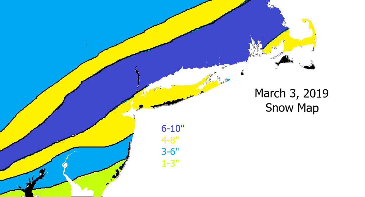
Unfortunately, I do think those south of CNJ and parts of the Jersey Shore will flip to rain at some point. I'm having a tough time figuring out how FAR south though. Maybe just the Cape May area, or as far north as Point Pleasant? My preliminary snow map (Figure 3.0) shown below tries to take that into consideration. What you will also see in the images below are the temperatures. The 850mb/925mb are expected to be cold for this system. However, the surface temps look like they will be above freezing for some. You can see how the surface temps are in the upper 30's to low 40's for parts of the area which is why I'm hesitant of higher snow amounts there.
By looking at the 500mb set-up it's easy to see where the dynamics will come from. The coastal low associated with the southern stream is riding the SE Ridge (Figure 4.0), while the PV lobe sits just north of the Great Lakes pressing the trough S&E. The trough and confluent energy at 500mb is preventing this coastal storm from cutting to our west. However, there will not be a phase with northern stream energy. Its purely southern stream driven. This is the main reason why an organized coastal storm with a well defined center will not form. Nevertheless, it will be a fun event because of the dynamics.
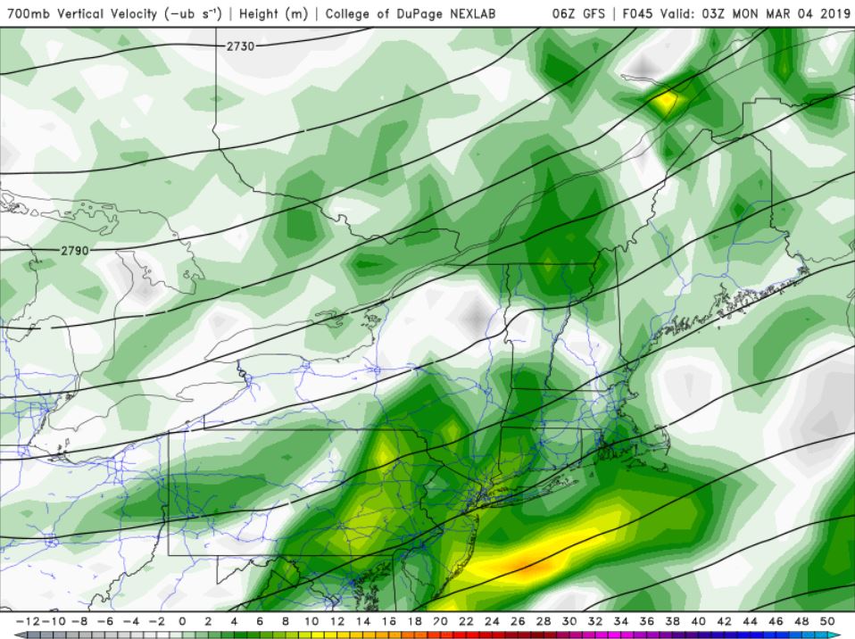
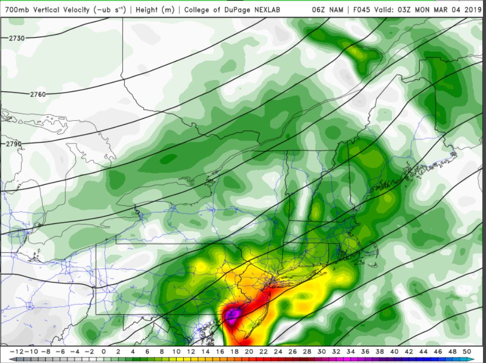
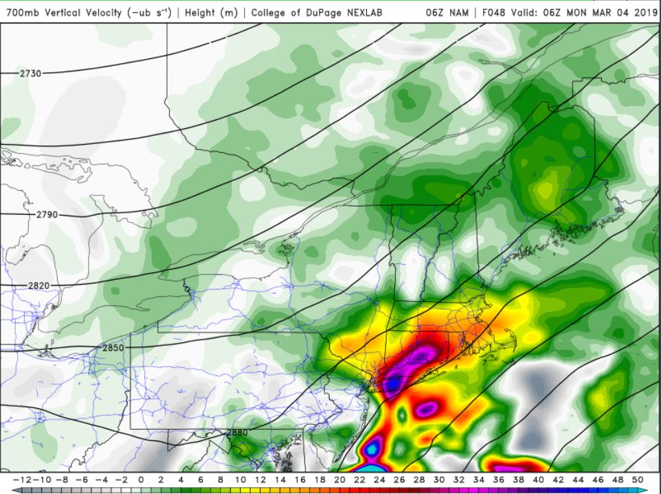
Because of this 500mb set-up, upward motion (measured at 700mb) should be impressive. The VV (vertical velocity) maps prove it indeed is depending on the model you look at. The GFS (Figure 5.0) has +2 to +10 VV's throughout the area. Snowfall rates will not be too crazy but moderate enough. Meanwhile, the NAM (Figures 6.0 & 7.0), shows very impressive VV's that could result in 1"+/hour snowfall rates. But notice how the VV's are more concentrated here than they are widespread like the GFS. The greatest VV's tend to be closer to the baroclinic zone.
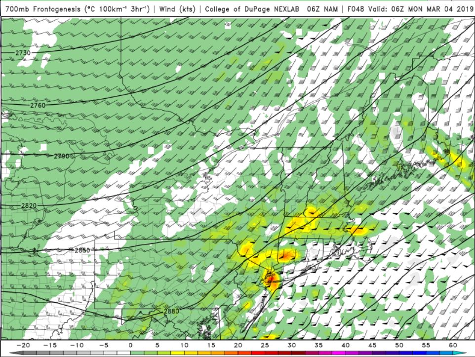
700mb frontogenesis is where you'll find a deformation band try to set-up. Your best lift and snow growth, often where best snowfall rates occur also, is found here. The NAM (Figure 8.0) does show some moderate frontogenesis for NYC and N&W. There could be a period of very heavy snow that falls overnight Sunday or early Monday morning, easily dropping a few inches in just a couple of hours.
Figure 3.0
Figure 4.0
Figure 5.0
Figure 6.0 & 7.0
Figure 8.0


weatherwatchermom- Senior Enthusiast
- Posts : 3738
Reputation : 77
Join date : 2014-11-25
Age : 60
Location : Hazlet Township, NJ
Re: Sun/Monday March 3rd-4th 2019 Storm
![]() by WeatherBob Sat Mar 02, 2019 12:41 pm
by WeatherBob Sat Mar 02, 2019 12:41 pm

WeatherBob- Meteorologist

- Posts : 683
Reputation : 83
Join date : 2013-12-13
Location : Caldwell, NJ - NW Essex County - Altitude 500 FT
Re: Sun/Monday March 3rd-4th 2019 Storm
![]() by Sanchize06 Sat Mar 02, 2019 12:50 pm
by Sanchize06 Sat Mar 02, 2019 12:50 pm
Sanchize06- Senior Enthusiast
- Posts : 1041
Reputation : 21
Join date : 2013-02-05
Location : Union Beach, NJ
Re: Sun/Monday March 3rd-4th 2019 Storm
![]() by Sanchize06 Sat Mar 02, 2019 12:56 pm
by Sanchize06 Sat Mar 02, 2019 12:56 pm
Sanchize06- Senior Enthusiast
- Posts : 1041
Reputation : 21
Join date : 2013-02-05
Location : Union Beach, NJ
Re: Sun/Monday March 3rd-4th 2019 Storm
![]() by Frank_Wx Sat Mar 02, 2019 12:59 pm
by Frank_Wx Sat Mar 02, 2019 12:59 pm
_________________
_______________________________________________________________________________________________________
CLICK HERE to view NJ Strong Snowstorm Classifications
Frank_Wx- Godzilla Seeker
- Posts : 21305
Reputation : 328
Join date : 2013-01-05
Age : 31
Location : Jersey City, NJ -
Re: Sun/Monday March 3rd-4th 2019 Storm
![]() by heehaw453 Sat Mar 02, 2019 1:33 pm
by heehaw453 Sat Mar 02, 2019 1:33 pm
heehaw453- Advanced Forecaster
- Posts : 3906
Reputation : 86
Join date : 2014-01-20
Location : Bedminster Township, PA Elevation 600' ASL
Re: Sun/Monday March 3rd-4th 2019 Storm
![]() by Irish Sat Mar 02, 2019 1:45 pm
by Irish Sat Mar 02, 2019 1:45 pm
Irish- Pro Enthusiast
- Posts : 788
Reputation : 19
Join date : 2019-01-16
Age : 45
Location : Old Bridge, NJ
Re: Sun/Monday March 3rd-4th 2019 Storm
![]() by heehaw453 Sat Mar 02, 2019 1:47 pm
by heehaw453 Sat Mar 02, 2019 1:47 pm
heehaw453- Advanced Forecaster
- Posts : 3906
Reputation : 86
Join date : 2014-01-20
Location : Bedminster Township, PA Elevation 600' ASL
Re: Sun/Monday March 3rd-4th 2019 Storm
![]() by heehaw453 Sat Mar 02, 2019 1:49 pm
by heehaw453 Sat Mar 02, 2019 1:49 pm
Irish wrote:Is there a place here where all the abbreviations are defined? Like BM, cause i know it's not bowel movement.
It means 40/70 latitude/longitude. Not far from Montauk Point Long Island.
heehaw453- Advanced Forecaster
- Posts : 3906
Reputation : 86
Join date : 2014-01-20
Location : Bedminster Township, PA Elevation 600' ASL
Re: Sun/Monday March 3rd-4th 2019 Storm
![]() by hyde345 Sat Mar 02, 2019 1:50 pm
by hyde345 Sat Mar 02, 2019 1:50 pm
Irish wrote:Is there a place here where all the abbreviations are defined? Like BM, cause i know it's not bowel movement.
BM means benchmark which is 40N/70W. Lows that track to benchmark generally give NYC metro good snows.

hyde345- Pro Enthusiast
- Posts : 1082
Reputation : 48
Join date : 2013-01-08
Location : Hyde Park, NY
Irish- Pro Enthusiast
- Posts : 788
Reputation : 19
Join date : 2019-01-16
Age : 45
Location : Old Bridge, NJ
Re: Sun/Monday March 3rd-4th 2019 Storm
![]() by CPcantmeasuresnow Sat Mar 02, 2019 1:53 pm
by CPcantmeasuresnow Sat Mar 02, 2019 1:53 pm
Irish wrote:Is there a place here where all the abbreviations are defined? Like BM, cause i know it's not bowel movement.
Unless the person posting happened to be in the john at the time. We have to consider all possibilities.

CPcantmeasuresnow- Wx Statistician Guru

- Posts : 7274
Reputation : 230
Join date : 2013-01-07
Age : 103
Location : Eastern Orange County, NY
Re: Sun/Monday March 3rd-4th 2019 Storm
![]() by Joe Snow Sat Mar 02, 2019 2:09 pm
by Joe Snow Sat Mar 02, 2019 2:09 pm
Irish wrote:Is there a place here where all the abbreviations are defined? Like BM, cause i know it's not bowel movement.
BM= Bench Mark

Joe Snow- Pro Enthusiast
- Posts : 924
Reputation : 7
Join date : 2014-02-12
Age : 62
Location : Sanford Florida, Fmrly Kings Park, NY
Re: Sun/Monday March 3rd-4th 2019 Storm
![]() by heehaw453 Sat Mar 02, 2019 2:18 pm
by heehaw453 Sat Mar 02, 2019 2:18 pm
heehaw453- Advanced Forecaster
- Posts : 3906
Reputation : 86
Join date : 2014-01-20
Location : Bedminster Township, PA Elevation 600' ASL
Page 4 of 22 • 1, 2, 3, 4, 5 ... 13 ... 22 ![]()
|
|
|