Long Range Thread 19.0
+38
essexcountypete
SoulSingMG
Scullybutcher
phil155
bobjohnsonforthehall
Zhukov1945
dsix85
Radz
lja
Grselig
devsman
DAYBLAZER
Irish
Dunnzoo
jimv45
sabamfa
SENJsnowman
frank 638
heehaw453
skinsfan1177
sroc4
hyde345
CPcantmeasuresnow
Math23x7
nutleyblizzard
rb924119
weatherwatchermom
aiannone
jmanley32
billg315
dkodgis
Snow88
algae888
docstox12
HectorO
mwilli
amugs
Frank_Wx
42 posters
Page 26 of 28
Page 26 of 28 •  1 ... 14 ... 25, 26, 27, 28
 Re: Long Range Thread 19.0
We are counting on you Mr. Haw. It’s your opportunity to save winter. You can do it!
Grselig- Senior Enthusiast

- Posts : 1408
Join date : 2013-03-04

CPcantmeasuresnow- Wx Statistician Guru

- Posts : 7274
Reputation : 230
Join date : 2013-01-07
Age : 103
Location : Eastern Orange County, NY
 Re: Long Range Thread 19.0
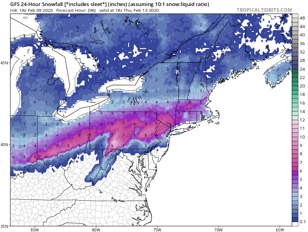
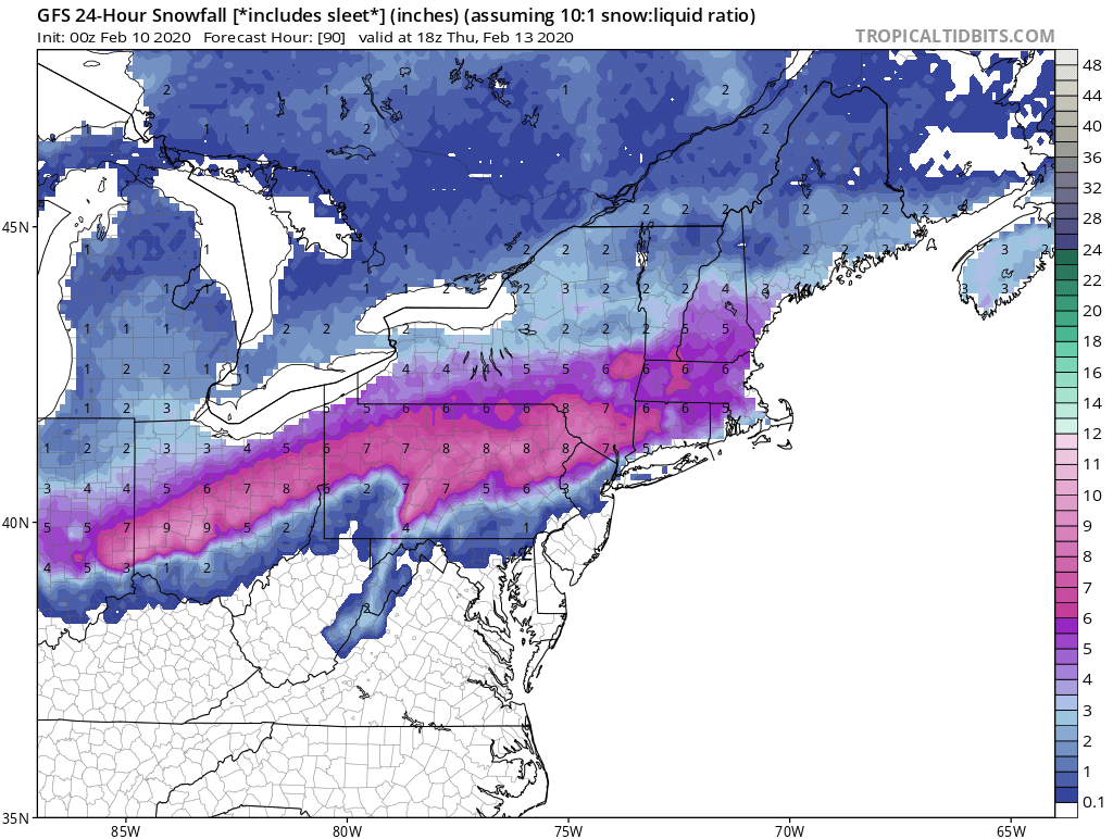
I am keeping an eye on this. I do think it will end up being more of a slop storm but we will see.
_________________
_______________________________________________________________________________________________________
CLICK HERE to view NJ Strong Snowstorm Classifications
 Re: Long Range Thread 19.0
Any hope for the coast? Or will this surely be for inland only? I can't make it out but doesnt look like much for coastal areas and if its mainly sleet...honestly I will take it if it gives us a early vacation starting the 14th : )Frank_Wx wrote:
I am keeping an eye on this. I do think it will end up being more of a slop storm but we will see.

jmanley32- Senior Enthusiast

- Posts : 20513
Reputation : 108
Join date : 2013-12-12
Age : 42
Location : Yonkers, NY
 Re: Long Range Thread 19.0
Frank_Wx wrote:
I am keeping an eye on this. I do think it will end up being more of a slop storm but we will see.
00z GFS (and NAM as far as I can tell) scream the dread word "cutter"

Zhukov1945- Posts : 138
Reputation : 8
Join date : 2018-03-21
Location : Clinton Township NJ

CPcantmeasuresnow- Wx Statistician Guru

- Posts : 7274
Reputation : 230
Join date : 2013-01-07
Age : 103
Location : Eastern Orange County, NY

CPcantmeasuresnow- Wx Statistician Guru

- Posts : 7274
Reputation : 230
Join date : 2013-01-07
Age : 103
Location : Eastern Orange County, NY
 Re: Long Range Thread 19.0
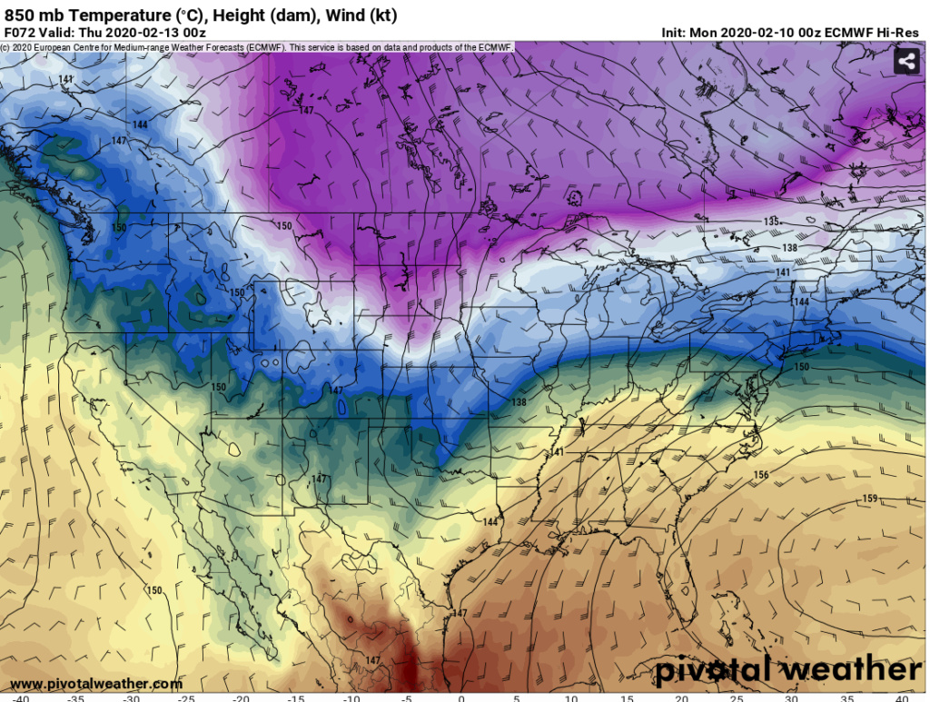
GFS is correcting itself each time to what the Euro has been showing for a few days. What's shown in below pictures is the kiss of death for snow as the storm is approaching.
This will cut and bring a strong south westerly flow well out ahead of it at the mid levels and the surface. The antecedent air mass is very marginal. Euro is trying to show an inch of slop preceding the flip in the HV. I'm highly skeptical of even that verbatim. If there was arctic air as the antecedent air mass to setup an overrunning event OR we had some Atlantic blocking in place to trap COLD high pressure over Quebec, then I'd be very interested in this. We have the same bad scenario play out each time and it's like a broken record.
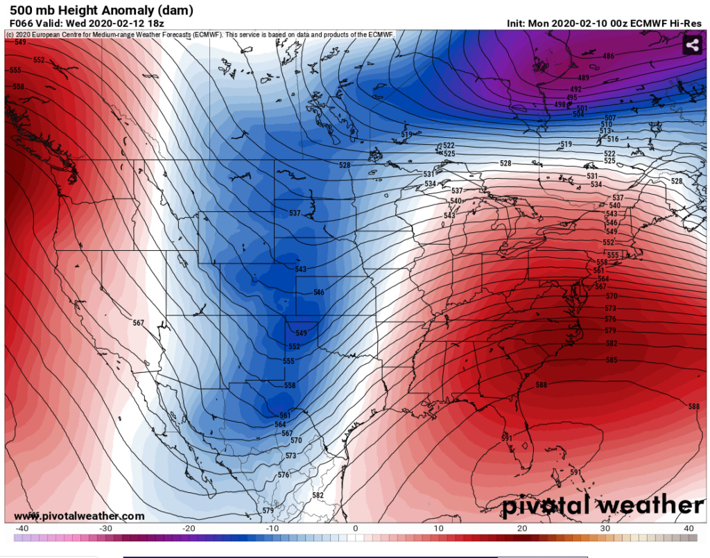
This will cut and bring a strong south westerly flow well out ahead of it at the mid levels and the surface. The antecedent air mass is very marginal. Euro is trying to show an inch of slop preceding the flip in the HV. I'm highly skeptical of even that verbatim. If there was arctic air as the antecedent air mass to setup an overrunning event OR we had some Atlantic blocking in place to trap COLD high pressure over Quebec, then I'd be very interested in this. We have the same bad scenario play out each time and it's like a broken record.


heehaw453- Advanced Forecaster

- Posts : 3906
Reputation : 86
Join date : 2014-01-20
Location : Bedminster Township, PA Elevation 600' ASL
 Re: Long Range Thread 19.0
There is a short wave on Sunday that could drop some snow. Below pictures are Euro 500mb and 700mb moisture transport. The air mass is plenty cold to support snow for once.
Don't care for the tilt of the trough or the limited moisture supply (disconnected from subtropical plume), so I don't think any more than 2" is possible ATTM. But since I'll be in Stowe this weekend it'll probably morph into something bigger by hooking up with the subtropical moisture.
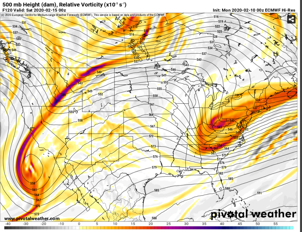
Limited moisture supply completely cut off.
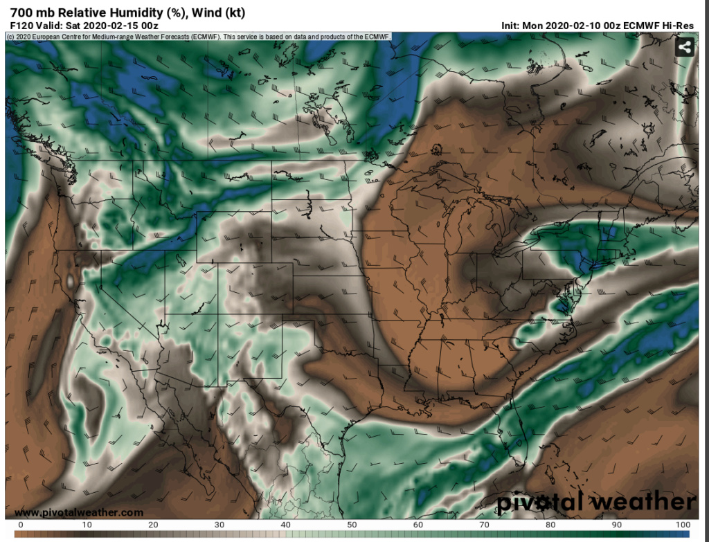
Don't care for the tilt of the trough or the limited moisture supply (disconnected from subtropical plume), so I don't think any more than 2" is possible ATTM. But since I'll be in Stowe this weekend it'll probably morph into something bigger by hooking up with the subtropical moisture.

Limited moisture supply completely cut off.

heehaw453- Advanced Forecaster

- Posts : 3906
Reputation : 86
Join date : 2014-01-20
Location : Bedminster Township, PA Elevation 600' ASL
 Re: Long Range Thread 19.0
the pattern just has not worked out at all for us this Winter and I do not see anything down the road (granted my skills are limited compared to most here) that suggests a change and unless by chance a system times out just right with somewhat rare and progressive cold shots we have been seeing this depressing winter will likely just play out as it has been till the end
phil155- Pro Enthusiast

- Posts : 475
Reputation : 4
Join date : 2019-12-16
 Re: Long Range Thread 19.0
phil155 wrote:the pattern just has not worked out at all for us this Winter and I do not see anything down the road (granted my skills are limited compared to most here) that suggests a change and unless by chance a system times out just right with somewhat rare and progressive cold shots we have been seeing this depressing winter will likely just play out as it has been till the end
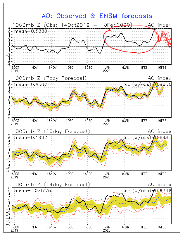
Very possible. The Arctic Oscillation being negative or at least neutral is extremely important for coast's snow chances and important for interior chances of meaningful snow at this latitude. Especially as it gets deeper into February. The latest Euro Ensembles suggest some slightly negative values after D10. I don't trust D10 ensemble guidance and the fact remains it's been anomalously high most of winter. Will it change and give us a favorable period? Maybe?
This graph tells the story of this winter quite well. Note it was consistently negative in November and how that corresponded to our BN temperatures in November. Also, note that right as the pattern flipped you had the nice snow event for some beginning of December.
heehaw453- Advanced Forecaster

- Posts : 3906
Reputation : 86
Join date : 2014-01-20
Location : Bedminster Township, PA Elevation 600' ASL
 Re: Long Range Thread 19.0
Continue seeing hostile 500mb conditions right past February 20.
Deep troughs in the high latitudes between Alaska and Greenland indicative +NAO,+EPO,+AO.
Troughs extend from Yukon to Montana and consequently ridging in the mid latitude Atlantic basin indicative of -PNA.
This is all wrong for wintry weather here.
There will be transient shots of marginally colder air with minimal depth. Very similar to today that will be eroded quickly.
I guess I'm saying I think Jersey coastal plain is going to be tough to get anything significant the rest of the way. March I'm very skeptical of there just due to climatology. Even during good 500mb it's tough to battle climatology.
Interior may not render much better without some help in the 500mb. There's more tolerance west of the Fall Line, but unless the 500mb changes in March there won't be much there either.
As it stands now this is top 5 ratter IMO all things considered and may very up hold up.
heehaw453- Advanced Forecaster

- Posts : 3906
Reputation : 86
Join date : 2014-01-20
Location : Bedminster Township, PA Elevation 600' ASL
 Re: Long Range Thread 19.0
Stick a fork in it, I just wish if its not going to snow then I would prefer it be warm, it would be so much easier in many ways. Biggest way...getting the kids undressed and dressed to go home at work, man what a hasstle.

jmanley32- Senior Enthusiast

- Posts : 20513
Reputation : 108
Join date : 2013-12-12
Age : 42
Location : Yonkers, NY
 Re: Long Range Thread 19.0
jmanley32 wrote:Stick a fork in it, I just wish if its not going to snow then I would prefer it be warm, it would be so much easier in many ways. Biggest way...getting the kids undressed and dressed to go home at work, man what a hasstle.
It's all over
Bkdude- Posts : 87
Reputation : 0
Join date : 2016-01-01
 Re: Long Range Thread 19.0
Banter in banter.
_________________
"In weather and in life, there's no winning and losing; there's only winning and learning."
WINTER 2012/2013 TOTALS 43.65"WINTER 2017/2018 TOTALS 62.85" WINTER 2022/2023 TOTALS 4.9"
WINTER 2013/2014 TOTALS 64.85"WINTER 2018/2019 TOTALS 14.25" WINTER 2023/2024 TOTALS 13.1"
WINTER 2014/2015 TOTALS 71.20"WINTER 2019/2020 TOTALS 6.35"
WINTER 2015/2016 TOTALS 35.00"WINTER 2020/2021 TOTALS 37.75"
WINTER 2016/2017 TOTALS 42.25"WINTER 2021/2022 TOTALS 31.65"

sroc4- Admin

- Posts : 8331
Reputation : 301
Join date : 2013-01-07
Location : Wading River, LI
 Re: Long Range Thread 19.0
There is chatter about D12+ looks on the ensembles looking much better.
I'll go out to 10 days (2/23) and yes it's not as hostile. Ridging is building west of Continental Divide and gone from mid-Atlantic region (better PNA look), but there's still so much work to be done in the arctic and sub-arctic regions. If this look was late January view instead of late February I'd more enthusiastic. In order to get a decent March we're going to need a lot more consistent help in the NAM state. Windows are just closing really fast.
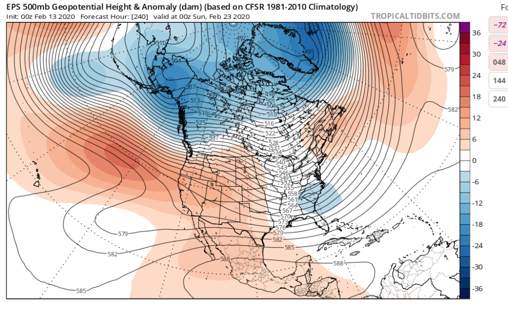
I'll go out to 10 days (2/23) and yes it's not as hostile. Ridging is building west of Continental Divide and gone from mid-Atlantic region (better PNA look), but there's still so much work to be done in the arctic and sub-arctic regions. If this look was late January view instead of late February I'd more enthusiastic. In order to get a decent March we're going to need a lot more consistent help in the NAM state. Windows are just closing really fast.

heehaw453- Advanced Forecaster

- Posts : 3906
Reputation : 86
Join date : 2014-01-20
Location : Bedminster Township, PA Elevation 600' ASL
 Re: Long Range Thread 19.0
A consistently strong polar vortex has kept cold outta town and the ENSO neutral winter pattern has whipped us pretty good. I tend to think of weather as being driven by one or two things but I have learned that is not so (here). I see temperature forecasts being above average for March into April. If some snow comes, great. I remain, gasp!, optimistic because I remember a few April blizzards (that melted fast).
https://www.youtube.com/watch?v=Sl_wkNQJp5s
https://www.youtube.com/watch?v=Sl_wkNQJp5s

dkodgis- Senior Enthusiast

- Posts : 2493
Reputation : 98
Join date : 2013-12-29
 Re: Long Range Thread 19.0
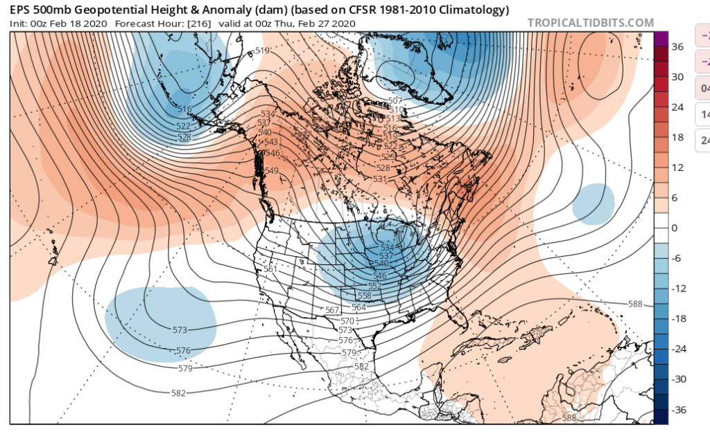
This look is much more hospitable to winter weather chances towards end of February. It seems a more sustained cold shot will be possible with the -AO, -EPO. Ridge in the Atlantic is dissipating too. GEFS has agreement with EPS at the high level. So I think it'll get colder for a period of time end of February into first week of March.
IMO that will be best chance of getting more snow before we run out of time. That is not a high bar though considering the hostile pattern we've had since mid December. I also believe the arctic will bounce back to +AO in short order, so I think this period is it. Not to mention climatology. I also don't see evidence of high latitude blocking (-NAO) or a nice Pacific (+PNA) which I think is important for major events as we get into March.
So in summary a colder period is high confidence into first week of March, major snows are low confidence. Do have some decent confidence some snow will fall though... Let's see.

heehaw453- Advanced Forecaster

- Posts : 3906
Reputation : 86
Join date : 2014-01-20
Location : Bedminster Township, PA Elevation 600' ASL
 Re: Long Range Thread 19.0
I see the warmup by the end of the week. I see some folks calling for that cold air ten-dayish from now. If any snow is late, better than never

dkodgis- Senior Enthusiast

- Posts : 2493
Reputation : 98
Join date : 2013-12-29
 Re: Long Range Thread 19.0
Watch the 2/27 time frame. The NAM state is much better with -AO and neutral EPO. Cold press will be coming from Canada and EPS is on board for a storm which I think will be helped by the building ridge towards Continental Divide. That building ridge should cause trough to dig and drag colder air down. The Atlantic ridge will be quickly moved too as the trough swings through.
That's the best look I've seen in a long while here. Will it render anything, who knows, but this is a lot more interesting than the garbage we've been looking at.
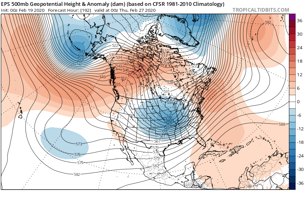
That's the best look I've seen in a long while here. Will it render anything, who knows, but this is a lot more interesting than the garbage we've been looking at.

heehaw453- Advanced Forecaster

- Posts : 3906
Reputation : 86
Join date : 2014-01-20
Location : Bedminster Township, PA Elevation 600' ASL
 Re: Long Range Thread 19.0
Hopefully March will come in roaring like a lion,one secs would work for me.
mwilli- Posts : 132
Reputation : 3
Join date : 2019-02-11
 Re: Long Range Thread 19.0
heehaw453 wrote:Watch the 2/27 time frame. The NAM state is much better with -AO and neutral EPO. Cold press will be coming from Canada and EPS is on board for a storm which I think will be helped by the building ridge towards Continental Divide. That building ridge should cause trough to dig and drag colder air down. The Atlantic ridge will be quickly moved too as the trough swings through.
That's the best look I've seen in a long while here. Will it render anything, who knows, but this is a lot more interesting than the garbage we've been looking at.
We shall see. A few things to note. The true AO domain still looks overall positive. As we move in closer with time and the ensemble mean zeros in on where the ridging will be I worry that there will still be negatives along the WC which in turn means we cont to get modified Pac air for any potential system rather than any real arctic air. similar to the minor events the areas just N&W experienced in Jan.
If this is the case we once again have to hope for perfect timing for N and S energy and hope that the S energy isnt too strong or else it pumps heights out ahead taking the coastal plain yet again out of the equation and areas NW will be on the cutoff, followed by a legitimate cold shot behind the late phasing system.
For me this is better than what we have had for Feb but not much different that what we had in the first part of Jan where only a select few on this board at least might benefit. That said I am only evaluating the ensemble mean look here and nothing else.

_________________
"In weather and in life, there's no winning and losing; there's only winning and learning."
WINTER 2012/2013 TOTALS 43.65"WINTER 2017/2018 TOTALS 62.85" WINTER 2022/2023 TOTALS 4.9"
WINTER 2013/2014 TOTALS 64.85"WINTER 2018/2019 TOTALS 14.25" WINTER 2023/2024 TOTALS 13.1"
WINTER 2014/2015 TOTALS 71.20"WINTER 2019/2020 TOTALS 6.35"
WINTER 2015/2016 TOTALS 35.00"WINTER 2020/2021 TOTALS 37.75"
WINTER 2016/2017 TOTALS 42.25"WINTER 2021/2022 TOTALS 31.65"

sroc4- Admin

- Posts : 8331
Reputation : 301
Join date : 2013-01-07
Location : Wading River, LI
 Re: Long Range Thread 19.0
sroc4 wrote:heehaw453 wrote:Watch the 2/27 time frame. The NAM state is much better with -AO and neutral EPO. Cold press will be coming from Canada and EPS is on board for a storm which I think will be helped by the building ridge towards Continental Divide. That building ridge should cause trough to dig and drag colder air down. The Atlantic ridge will be quickly moved too as the trough swings through.
That's the best look I've seen in a long while here. Will it render anything, who knows, but this is a lot more interesting than the garbage we've been looking at.
We shall see. A few things to note. The true AO domain still looks overall positive. As we move in closer with time and the ensemble mean zeros in on where the ridging will be I worry that there will still be negatives along the WC which in turn means we cont to get modified Pac air for any potential system rather than any real arctic air. similar to the minor events the areas just N&W experienced in Jan.
If this is the case we once again have to hope for perfect timing for N and S energy and hope that the S energy isnt too strong or else it pumps heights out ahead taking the coastal plain yet again out of the equation and areas NW will be on the cutoff, followed by a legitimate cold shot behind the late phasing system.
For me this is better than what we have had for Feb but not much different that what we had in the first part of Jan where only a select few on this board at least might benefit. That said I am only evaluating the ensemble mean look here and nothing else.
Good point sroc. It's more subarctic ridging and i think true AO gets close to neutral though.
To me the cold won't be well established on 2/27, but I focus on the ridging in the PNA region. If that gets pumped enough, then the trough can dig and pull colder air down and then short wave energy slides under us. That to me is what makes or breaks the threat. Regardless I don't see major snow out of this threat without building high latitude ridging in Greenland which there is no evidence of ATTM.
After 2/27 though this subarctic ridging will have pressed the cold down and then it's probably cold first week of March. When we have the cold established then maybe we can have another threat show up before the warm air comes back. I think this window from end of February to first week of March is probably end of snow threats if the we go back to ++AO as I believe we will.
Todays 12Z Euro is a nice solution for us. Let's see in a few days how it looks...
heehaw453- Advanced Forecaster

- Posts : 3906
Reputation : 86
Join date : 2014-01-20
Location : Bedminster Township, PA Elevation 600' ASL
 Re: Long Range Thread 19.0
Last night's guidance isn't going to cut it for 2/27 threat wrt snow chances. The trough is much further to the west because the ridge axis is much more n/s as opposed to nw/se. When the ridge is n/s (as shown 0Z) then the two streams of the jet will combine and make a more robust storm that cuts way to our west and won't move east until the trough obliterates the Atlantic ridge. After the ridge is cleared it will give the upper level low room to move east. That type of scenario will be the usual 43 N latitude snow producer.
These are the goal posts IMO and the sharper (more N/S) the west ridge is the more likely a more robust storm develops early that gives us rain. If this ridge is more diagonally oriented, then the two streams stay separated longer and storm forms in much more favorable location for us. I'll give it a few days before sticking the fork in it, but not encouraging.
12Z run 2/19 (wintry solution)
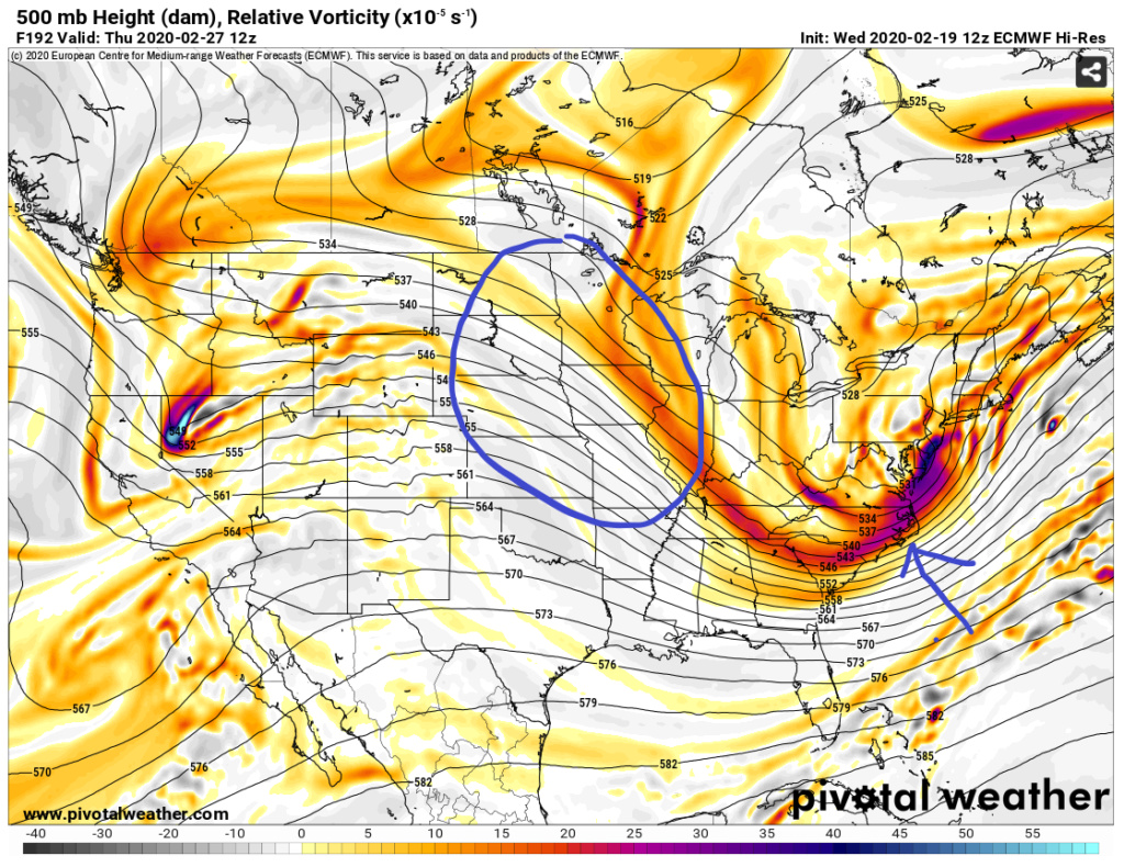
0Z run 2/20 (rain solution)
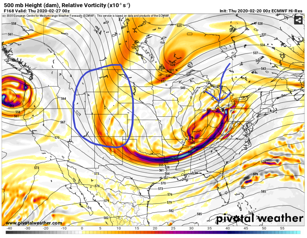
These are the goal posts IMO and the sharper (more N/S) the west ridge is the more likely a more robust storm develops early that gives us rain. If this ridge is more diagonally oriented, then the two streams stay separated longer and storm forms in much more favorable location for us. I'll give it a few days before sticking the fork in it, but not encouraging.
12Z run 2/19 (wintry solution)

0Z run 2/20 (rain solution)

heehaw453- Advanced Forecaster

- Posts : 3906
Reputation : 86
Join date : 2014-01-20
Location : Bedminster Township, PA Elevation 600' ASL

CPcantmeasuresnow- Wx Statistician Guru

- Posts : 7274
Reputation : 230
Join date : 2013-01-07
Age : 103
Location : Eastern Orange County, NY
 Re: Long Range Thread 19.0
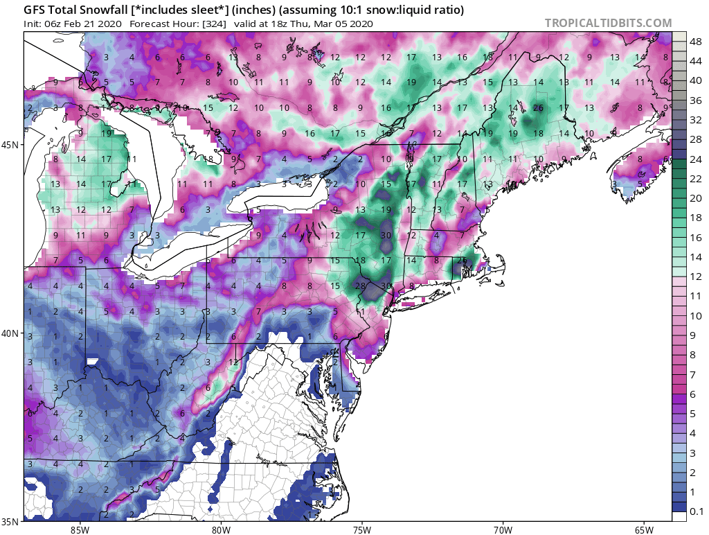
bad cp you know fantasy maps go in banter lol. Or have we tossed all sensibility due to this dead winter and hoping a off run produces 13 days out. Has it really come to this? You prolly have a better bet at winning the power ball 3x in a row. All in jest my friend in case it came across serious.

jmanley32- Senior Enthusiast

- Posts : 20513
Reputation : 108
Join date : 2013-12-12
Age : 42
Location : Yonkers, NY
Page 26 of 28 •  1 ... 14 ... 25, 26, 27, 28
Page 26 of 28
Permissions in this forum:
You cannot reply to topics in this forum|
|
|

 Home
Home
