
 Search
Monitoring February 4th
Page 1 of 13 • 1, 2, 3 ... 11, 12, 13 ![]()

Monitoring February 4th
![]() by Frank_Wx Mon Jan 31, 2022 12:10 pm
by Frank_Wx Mon Jan 31, 2022 12:10 pm
I did not want to clog the long range thread by discussing potential weather in the short range, so let's use this space to do just that. There are two potential winter weather events to watch out for. I signaled on the home page my level of confidence for each (obtaining at least 1" of snowfall in Central Park). In this thread we will focus on Friday's potential storm.
February 4th - Mothrazilla? Ice? Sleet? Rain?
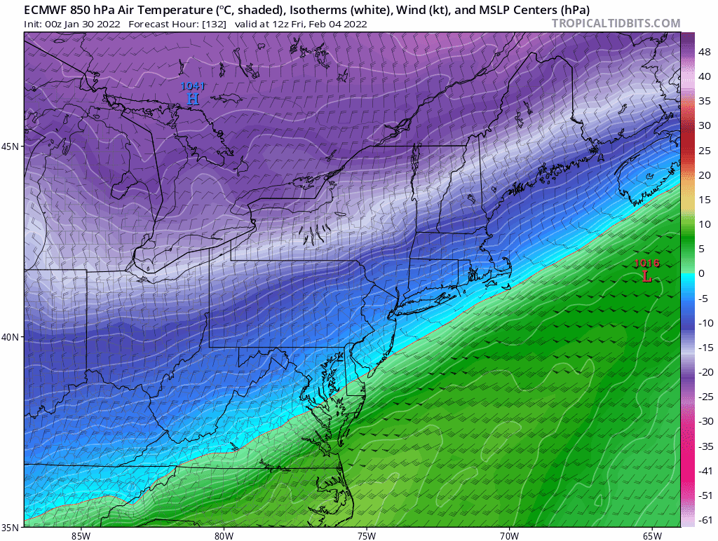
All of these precipitation types are on the tables. We're looking at one potentially messy, or dangerous, storm depending on what falls. There's no doubt there has been a cold trend on the models of late. The two heavy weights, GFS and EURO continue to look different with how far south the gradient gets.
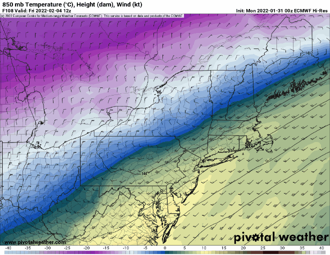
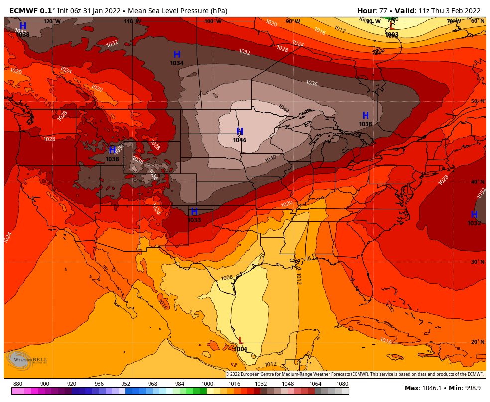
Notice how the 850mb temps on the GFS are at or below freezing for NYC and points N&W, while on the EURO nearly everyone is above freezing. There is a strong cold press on the GFS thanks to the presence of not one, but two High Pressure systems to our north:
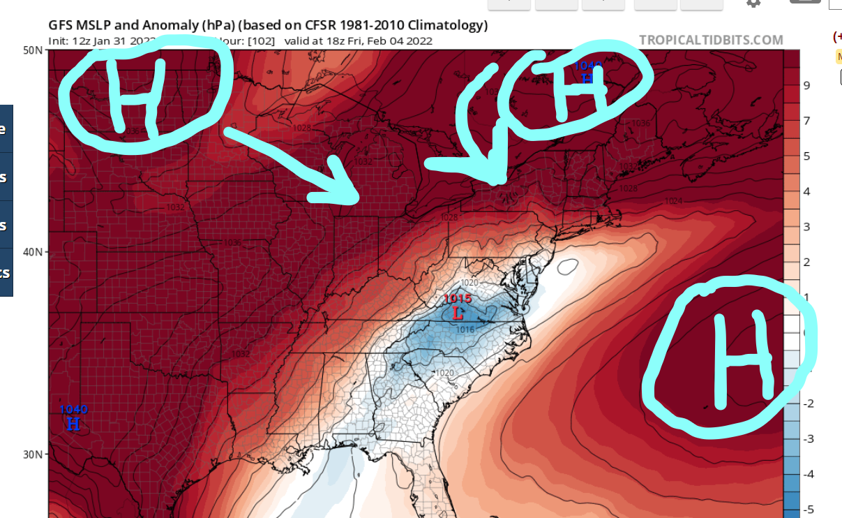
These are in response to the +PNA/-EPO ridges that are present over western parts of the U.S. and eastern Pacific. The EURO has these ridges either less amplified or back further west, which allows the Atlantic ridge to be closer to the coast and push the track of our surface low to our west-northwest.
The 00z EURO run from two nights ago was actually pretty cold, but you can see the last two runs it reverted back to the warmer solution.
That is a pretty drastic jump on the EURO, whereas the GFS has been consistent in showing a progressively colder storm as the runs go by. It's also worth mentioning that there's fresh snowpack across New England from last weekend's Godzilla, and that should help boost the cold air even more. So, as of now I'm leaning with the colder scenarios than I am with the warmer one's, but with the lack of high latitude blocking it would not take much for the EURO to be right. The key to this storm system will be the timing of the PNA ridge and how far south the High Pressure systems get. The baroclinic zone will set-up in a SW to NE orientation, and those NW of there will see quite a bit of overrunning and convective snow which could lead to Godzilla-like snowfall amounts. The threat for freezing rain is also there, however, too early to tell if freezing rain or sleet will be the primary concern. It could be both. We just need to wait and see. Hopefully we can get this thing to trend south-southeast enough to keep us all snow!
_________________
_______________________________________________________________________________________________________
CLICK HERE to view NJ Strong Snowstorm Classifications

Frank_Wx- Godzilla Seeker

- Posts : 21305
Reputation : 328
Join date : 2013-01-05
Age : 31
Location : Jersey City, NJ -

heehaw453 likes this post
Re: Monitoring February 4th
![]() by rb924119 Mon Jan 31, 2022 12:17 pm
by rb924119 Mon Jan 31, 2022 12:17 pm
As for the storm track, when you look at the press from the low-level cold air (as has been posted and demonstrated with the maps of the surface pressure anomalies), that is undeniably true. To have substantially higher pressure to the northwest of this system versus to the southeast and not expect the low-level boundary to trend further south would be akin to expecting water not to leak through a screen lol however, it’s the evolution aloft that needs to be watched to figure out how this storm evolves. Does the trough hold together and mature, or, does it shear out?
Yesterday I noted that the look of the West Coast ridge didn’t look like one that would support an inland cutter type track with a consolidating and strengthening low, but a more sheared and strung out system as the southern portion sags behind and hangs back in the Southwest (which has been a seasonal tendency this year, as previously stated by Frank), and the northern stream is allowed to progress and knock the northwestern flank of the ridge down. Trying to get a little bit better handle on this setup while I eat my breakfast, but I think that idea has merit, though it’s not going to be able to benefit all of us. I’ll have more on this at some point, but as a preview, my preliminary-preliminary thinking is that if you’re between the latitudes of I-195 and I-80 (or slightly north), that’s the icing zone, with snow north and rain south.

This threat is now dead. Thanks Frank……lmaooo jk, buddy! Nice write-up!
rb924119- Meteorologist

- Posts : 6889
Reputation : 194
Join date : 2013-02-06
Age : 32
Location : Greentown, Pa
Frank_Wx and amugs like this post
Re: Monitoring February 4th
![]() by lglickman1 Mon Jan 31, 2022 12:38 pm
by lglickman1 Mon Jan 31, 2022 12:38 pm
lglickman1- Pro Enthusiast

- Posts : 319
Reputation : 0
Join date : 2013-02-05
Location : New Rochelle, NY
Re: Monitoring February 4th
![]() by phil155 Mon Jan 31, 2022 12:40 pm
by phil155 Mon Jan 31, 2022 12:40 pm
phil155- Pro Enthusiast
- Posts : 475
Reputation : 4
Join date : 2019-12-16
Re: Monitoring February 4th
![]() by amugs Mon Jan 31, 2022 12:46 pm
by amugs Mon Jan 31, 2022 12:46 pm
I see what your saying and wish we had block too.
IF we had a very amped, phased storm I could see that west northwest unless it finds a weakness in between teh two HP's but the amount of HPs at 1045/48 levels that encompass the region to the N this would be hard to see how this escapes NW. They will exert their force on this pattern. It gets shoved along the boundary layer. That massive snowpack is going to aid and the arctic air is again extremely cold dense air. It's a race and we'll see who wins this and we shall see.
_________________
Mugs
AKA:King: Snow Weenie
Self Proclaimed
WINTER 2014-15 : 55.12" +.02 for 6 coatings (avg. 35")
WINTER 2015-16 Total - 29.8" (Avg 35")
WINTER 2016-17 : 39.5" so far

amugs- Advanced Forecaster - Mod

- Posts : 15093
Reputation : 213
Join date : 2013-01-07
Age : 54
Location : Hillsdale,NJ
Re: Monitoring February 4th
![]() by Frank_Wx Mon Jan 31, 2022 12:47 pm
by Frank_Wx Mon Jan 31, 2022 12:47 pm
lglickman1 wrote:Is it expected to rain on Thursday before the Friday system comes in, or is this all one system? (Looking at TWC app, I know it's not accurate but just noticed it in the forecast) thanks!
Technically one system but there are two waves riding along the same arctic front. The first wave comes in late Thursday and the more potent wave arrives on Friday. I have a feeling almost everyone will start out as plain rain Thursday afternoon unless this storm trends SIGNIFICANTLY south, which is not yet out of question.
_________________
_______________________________________________________________________________________________________
CLICK HERE to view NJ Strong Snowstorm Classifications
Frank_Wx- Godzilla Seeker
- Posts : 21305
Reputation : 328
Join date : 2013-01-05
Age : 31
Location : Jersey City, NJ -
Re: Monitoring February 4th
![]() by heehaw453 Mon Jan 31, 2022 12:52 pm
by heehaw453 Mon Jan 31, 2022 12:52 pm
rb924119 wrote:One thing that I will say about this, is that in my opinion, this is not a widespread freezing rain/sleet event for most. This is going to be a very steep front through the column, which will keep the expanse of the warm nose aloft (the +0C portion of it) limited on the cold side of the front, and should lead to a narrow zone (30-50 miles wide) of freezing rain/sleet. The problem is whoever ends up in that zone will see some pretty impressive accretion.
As for the storm track, when you look at the press from the low-level cold air (as has been posted and demonstrated with the maps of the surface pressure anomalies), that is undeniably true. To have substantially higher pressure to the northwest of this system versus to the southeast and not expect the low-level boundary to trend further south would be akin to expecting water not to leak through a screen lol however, it’s the evolution aloft that needs to be watched to figure out how this storm evolves. Does the trough hold together and mature, or, does it shear out?
Yesterday I noted that the look of the West Coast ridge didn’t look like one that would support an inland cutter type track with a consolidating and strengthening low, but a more sheared and strung out system as the southern portion sags behind and hangs back in the Southwest (which has been a seasonal tendency this year, as previously stated by Frank), and the northern stream is allowed to progress and knock the northwestern flank of the ridge down. Trying to get a little bit better handle on this setup while I eat my breakfast, but I think that idea has merit, though it’s not going to be able to benefit all of us. I’ll have more on this at some point, but as a preview, my preliminary-preliminary thinking is that if you’re between the latitudes of I-195 and I-80 (or slightly north), that’s the icing zone, with snow north and rain south.
This threat is now dead. Thanks Frank……lmaooo jk, buddy! Nice write-up!
I think with the banana high you're going to get more of SW/NE baroclinic zone of the 850's. So I would say Poconos/LV/Warren/Morris would go over to snow with this.
heehaw453- Advanced Forecaster

- Posts : 3906
Reputation : 86
Join date : 2014-01-20
Location : Bedminster Township, PA Elevation 600' ASL
amugs likes this post
Re: Monitoring February 4th
![]() by amugs Mon Jan 31, 2022 1:06 pm
by amugs Mon Jan 31, 2022 1:06 pm

_________________
Mugs
AKA:King: Snow Weenie
Self Proclaimed
WINTER 2014-15 : 55.12" +.02 for 6 coatings (avg. 35")
WINTER 2015-16 Total - 29.8" (Avg 35")
WINTER 2016-17 : 39.5" so far
amugs- Advanced Forecaster - Mod
- Posts : 15093
Reputation : 213
Join date : 2013-01-07
Age : 54
Location : Hillsdale,NJ
Re: Monitoring February 4th
![]() by amugs Mon Jan 31, 2022 1:08 pm
by amugs Mon Jan 31, 2022 1:08 pm
heehaw453 wrote:rb924119 wrote:One thing that I will say about this, is that in my opinion, this is not a widespread freezing rain/sleet event for most. This is going to be a very steep front through the column, which will keep the expanse of the warm nose aloft (the +0C portion of it) limited on the cold side of the front, and should lead to a narrow zone (30-50 miles wide) of freezing rain/sleet. The problem is whoever ends up in that zone will see some pretty impressive accretion.
As for the storm track, when you look at the press from the low-level cold air (as has been posted and demonstrated with the maps of the surface pressure anomalies), that is undeniably true. To have substantially higher pressure to the northwest of this system versus to the southeast and not expect the low-level boundary to trend further south would be akin to expecting water not to leak through a screen lol however, it’s the evolution aloft that needs to be watched to figure out how this storm evolves. Does the trough hold together and mature, or, does it shear out?
Yesterday I noted that the look of the West Coast ridge didn’t look like one that would support an inland cutter type track with a consolidating and strengthening low, but a more sheared and strung out system as the southern portion sags behind and hangs back in the Southwest (which has been a seasonal tendency this year, as previously stated by Frank), and the northern stream is allowed to progress and knock the northwestern flank of the ridge down. Trying to get a little bit better handle on this setup while I eat my breakfast, but I think that idea has merit, though it’s not going to be able to benefit all of us. I’ll have more on this at some point, but as a preview, my preliminary-preliminary thinking is that if you’re between the latitudes of I-195 and I-80 (or slightly north), that’s the icing zone, with snow north and rain south.
This threat is now dead. Thanks Frank……lmaooo jk, buddy! Nice write-up!
I think with the banana high you're going to get more of SW/NE baroclinic zone of the 850's. So I would say Poconos/LV/Warren/Morris would go over to snow with this.
Hee Haw a few distinctly close storms in 1994:
http://www.raymondcmartinjr.com/weather/1994/04-Jan-94.html
http://www.raymondcmartinjr.com/weather/1994/07-Jan-94.html
http://www.raymondcmartinjr.com/weather/1994/17-Jan-94.html
_________________
Mugs
AKA:King: Snow Weenie
Self Proclaimed
WINTER 2014-15 : 55.12" +.02 for 6 coatings (avg. 35")
WINTER 2015-16 Total - 29.8" (Avg 35")
WINTER 2016-17 : 39.5" so far
amugs- Advanced Forecaster - Mod
- Posts : 15093
Reputation : 213
Join date : 2013-01-07
Age : 54
Location : Hillsdale,NJ
heehaw453 likes this post
Re: Monitoring February 4th
![]() by rb924119 Mon Jan 31, 2022 1:17 pm
by rb924119 Mon Jan 31, 2022 1:17 pm
heehaw453 wrote:rb924119 wrote:One thing that I will say about this, is that in my opinion, this is not a widespread freezing rain/sleet event for most. This is going to be a very steep front through the column, which will keep the expanse of the warm nose aloft (the +0C portion of it) limited on the cold side of the front, and should lead to a narrow zone (30-50 miles wide) of freezing rain/sleet. The problem is whoever ends up in that zone will see some pretty impressive accretion.
As for the storm track, when you look at the press from the low-level cold air (as has been posted and demonstrated with the maps of the surface pressure anomalies), that is undeniably true. To have substantially higher pressure to the northwest of this system versus to the southeast and not expect the low-level boundary to trend further south would be akin to expecting water not to leak through a screen lol however, it’s the evolution aloft that needs to be watched to figure out how this storm evolves. Does the trough hold together and mature, or, does it shear out?
Yesterday I noted that the look of the West Coast ridge didn’t look like one that would support an inland cutter type track with a consolidating and strengthening low, but a more sheared and strung out system as the southern portion sags behind and hangs back in the Southwest (which has been a seasonal tendency this year, as previously stated by Frank), and the northern stream is allowed to progress and knock the northwestern flank of the ridge down. Trying to get a little bit better handle on this setup while I eat my breakfast, but I think that idea has merit, though it’s not going to be able to benefit all of us. I’ll have more on this at some point, but as a preview, my preliminary-preliminary thinking is that if you’re between the latitudes of I-195 and I-80 (or slightly north), that’s the icing zone, with snow north and rain south.
This threat is now dead. Thanks Frank……lmaooo jk, buddy! Nice write-up!
I think with the banana high you're going to get more of SW/NE baroclinic zone of the 850's. So I would say Poconos/LV/Warren/Morris would go over to snow with this.
Sure, that’s certainly plausible. But the picture above is based on where I think we are going (at least as of early analysis). If we shear the trough out and let the southern end lag behind while the northern half progresses, then what you essentially have is the ridge (relatively speaking, think in terms of height anomalies) being forced to squeeze between the southern half and the northern half. If you do that, then you start reorienting the stream flow from a true southwesterly into more of a west-southwesterly or due westerly by the time the system gets here. So, if you looked at the storm track, it be more of an arc instead of a straight line. Again, this is based on my preliminary thinking, which is subject to change haha
I’m not exceedingly worried about the above image being explicitly verbatim, but I used it as more of an outline to highlight the approximate zone of likely significant ice accretion in my opinion. Figured it would be clearer than just stating “between xx and xx roads”, or “central and north-central Jersey”. Especially since “central Jersey” doesn’t exist for some people (fully aware of that debate, though not trying to sidetrack this thread
rb924119- Meteorologist
- Posts : 6889
Reputation : 194
Join date : 2013-02-06
Age : 32
Location : Greentown, Pa
heehaw453 and weatherwatchermom like this post
Re: Monitoring February 4th
![]() by heehaw453 Mon Jan 31, 2022 1:34 pm
by heehaw453 Mon Jan 31, 2022 1:34 pm
heehaw453- Advanced Forecaster
- Posts : 3906
Reputation : 86
Join date : 2014-01-20
Location : Bedminster Township, PA Elevation 600' ASL
Re: Monitoring February 4th
![]() by amugs Mon Jan 31, 2022 1:35 pm
by amugs Mon Jan 31, 2022 1:35 pm
_________________
Mugs
AKA:King: Snow Weenie
Self Proclaimed
WINTER 2014-15 : 55.12" +.02 for 6 coatings (avg. 35")
WINTER 2015-16 Total - 29.8" (Avg 35")
WINTER 2016-17 : 39.5" so far
amugs- Advanced Forecaster - Mod
- Posts : 15093
Reputation : 213
Join date : 2013-01-07
Age : 54
Location : Hillsdale,NJ
Re: Monitoring February 4th
![]() by mikeypizano Mon Jan 31, 2022 1:44 pm
by mikeypizano Mon Jan 31, 2022 1:44 pm

mikeypizano- Pro Enthusiast
- Posts : 1118
Reputation : 66
Join date : 2017-01-05
Age : 35
Location : Wilkes-Barre/Scranton, PA
brownie, heehaw453, Sparky Sparticles and phil155 like this post
Re: Monitoring February 4th
![]() by MattyICE Mon Jan 31, 2022 2:03 pm
by MattyICE Mon Jan 31, 2022 2:03 pm
MattyICE- Advanced Forecaster
- Posts : 249
Reputation : 6
Join date : 2017-11-10
Age : 38
Location : Clifton, NJ (Eastern Passaic County)
sroc4 likes this post
Re: Monitoring February 4th
![]() by phil155 Mon Jan 31, 2022 2:08 pm
by phil155 Mon Jan 31, 2022 2:08 pm
amugs wrote:GEFS - RAISE THE YELLOW CAUTION SWIM FLAGS!!!
central jersey definitely exists
phil155- Pro Enthusiast
- Posts : 475
Reputation : 4
Join date : 2019-12-16
weatherwatchermom likes this post
Re: Monitoring February 4th
![]() by amugs Mon Jan 31, 2022 2:08 pm
by amugs Mon Jan 31, 2022 2:08 pm
And a much weaker HP over SE Canada - it goes from a 1038 to a 1031. The slows the drilling of the colder air.
33NRain Qtown Maps


_________________
Mugs
AKA:King: Snow Weenie
Self Proclaimed
WINTER 2014-15 : 55.12" +.02 for 6 coatings (avg. 35")
WINTER 2015-16 Total - 29.8" (Avg 35")
WINTER 2016-17 : 39.5" so far
amugs- Advanced Forecaster - Mod
- Posts : 15093
Reputation : 213
Join date : 2013-01-07
Age : 54
Location : Hillsdale,NJ
Re: Monitoring February 4th
![]() by heehaw453 Mon Jan 31, 2022 2:50 pm
by heehaw453 Mon Jan 31, 2022 2:50 pm
MattyICE wrote:Just as an aside here - I don’t think (someone smarter can correct me) there is necessarily a simple and linear relationship between further south solution directly correlating with a definitively more snowy solution. There will be a lot of complexity with regard to lower, mid, and upper atmospheric levels and warmth and timing etc. I like Rays area for potential icing as it stands but barring a wholesale shake up to a vastly different evolution (which I suppose is slightly possible though unlikely) I don’t know if I see this evolving into anything significant as far as snow is concerned for the vast majority of the board.
There are many ways this could evolve into a more snowy solution for I95. 1/ Further push of the banana High forcing the baroclinic zone more SE (stronger High), 2/trailing wave form on a stalled front after the baroclinic zone has positioned itself in a good location. I can say this from past experience exactly where baroclinic zones setup and the waves that form on them is very fickle business. There are times models 5 days out show Boston getting crushed and then turns out Baltimore is getting the heavy snow as we get to 2 days out. I don't think there is good handle on the next 4-7 days to be quite honest.
heehaw453- Advanced Forecaster
- Posts : 3906
Reputation : 86
Join date : 2014-01-20
Location : Bedminster Township, PA Elevation 600' ASL
phil155 likes this post
Re: Monitoring February 4th
![]() by MattyICE Mon Jan 31, 2022 3:11 pm
by MattyICE Mon Jan 31, 2022 3:11 pm
heehaw453 wrote:MattyICE wrote:Just as an aside here - I don’t think (someone smarter can correct me) there is necessarily a simple and linear relationship between further south solution directly correlating with a definitively more snowy solution. There will be a lot of complexity with regard to lower, mid, and upper atmospheric levels and warmth and timing etc. I like Rays area for potential icing as it stands but barring a wholesale shake up to a vastly different evolution (which I suppose is slightly possible though unlikely) I don’t know if I see this evolving into anything significant as far as snow is concerned for the vast majority of the board.
There are many ways this could evolve into a more snowy solution for I95. 1/ Further push of the banana High forcing the baroclinic zone more SE (stronger High), 2/trailing wave form on a stalled front after the baroclinic zone has positioned itself in a good location. I can say this from past experience exactly where baroclinic zones setup and the waves that form on them is very fickle business. There are times models 5 days out show Boston getting crushed and then turns out Baltimore is getting the heavy snow as we get to 2 days out. I don't think there is good handle on the next 4-7 days to be quite honest.
Yeah, no I get that, for sure. But I think unless we can get the orientation to change a snowy scenario is unlikely. Currently it’s very SW to NE and functions more as an Anafront look than a SWFE. The former is way more fickle and typically doesn’t work out. If we press the HP more from the West without a stronger TPV press into SE Canada then the orientation doesn’t change much. Limited precip left after the front passes. My other point was just based on upper levels you could end up at 30° outside and still
A sleetfest, not necessarily snow. Just thoughts. I agree with your options.
MattyICE- Advanced Forecaster
- Posts : 249
Reputation : 6
Join date : 2017-11-10
Age : 38
Location : Clifton, NJ (Eastern Passaic County)
Re: Monitoring February 4th
![]() by heehaw453 Mon Jan 31, 2022 3:27 pm
by heehaw453 Mon Jan 31, 2022 3:27 pm
MattyICE wrote:heehaw453 wrote:MattyICE wrote:Just as an aside here - I don’t think (someone smarter can correct me) there is necessarily a simple and linear relationship between further south solution directly correlating with a definitively more snowy solution. There will be a lot of complexity with regard to lower, mid, and upper atmospheric levels and warmth and timing etc. I like Rays area for potential icing as it stands but barring a wholesale shake up to a vastly different evolution (which I suppose is slightly possible though unlikely) I don’t know if I see this evolving into anything significant as far as snow is concerned for the vast majority of the board.
There are many ways this could evolve into a more snowy solution for I95. 1/ Further push of the banana High forcing the baroclinic zone more SE (stronger High), 2/trailing wave form on a stalled front after the baroclinic zone has positioned itself in a good location. I can say this from past experience exactly where baroclinic zones setup and the waves that form on them is very fickle business. There are times models 5 days out show Boston getting crushed and then turns out Baltimore is getting the heavy snow as we get to 2 days out. I don't think there is good handle on the next 4-7 days to be quite honest.
Yeah, no I get that, for sure. But I think unless we can get the orientation to change a snowy scenario is unlikely. Currently it’s very SW to NE and functions more as an Anafront look than a SWFE. The former is way more fickle and typically doesn’t work out. If we press the HP more from the West without a stronger TPV press into SE Canada then the orientation doesn’t change much. Limited precip left after the front passes. My other point was just based on upper levels you could end up at 30° outside and still
A sleetfest, not necessarily snow. Just thoughts. I agree with your options.
Yeah. Not in this scenario. We don't have antecedent cold air mass for SWFE. We are in a race to bring the cold air in and I absolutely agree Friday's wave most likely isn't turning to accumulating snow expect far NW of I95 (Poconos/I-81/LHV/NW NJ). After that if the front can stall favorably then another wave can form on it for better chances for points SE.
heehaw453- Advanced Forecaster
- Posts : 3906
Reputation : 86
Join date : 2014-01-20
Location : Bedminster Township, PA Elevation 600' ASL
MattyICE likes this post
Re: Monitoring February 4th
![]() by TheAresian Mon Jan 31, 2022 3:34 pm
by TheAresian Mon Jan 31, 2022 3:34 pm
TheAresian- Senior Enthusiast

- Posts : 145
Reputation : 10
Join date : 2019-11-13
Location : Painted Post, NY
Re: Monitoring February 4th
![]() by frank 638 Mon Jan 31, 2022 3:44 pm
by frank 638 Mon Jan 31, 2022 3:44 pm
frank 638- Senior Enthusiast
- Posts : 2824
Reputation : 37
Join date : 2016-01-01
Age : 40
Location : bronx ny
Re: Monitoring February 4th
![]() by heehaw453 Mon Jan 31, 2022 4:14 pm
by heehaw453 Mon Jan 31, 2022 4:14 pm
TheAresian wrote:I'm all for snow far west of I95, west of I81 for that matter. How long will it be (just a guess will do) before there's a better hold on the path and temp layers?
I think next 24 hours GFS aligns to Euro or Vice Versa. My guess Euro will be aligning with GFS.
heehaw453- Advanced Forecaster
- Posts : 3906
Reputation : 86
Join date : 2014-01-20
Location : Bedminster Township, PA Elevation 600' ASL
amugs likes this post
Re: Monitoring February 4th
![]() by TheAresian Mon Jan 31, 2022 4:24 pm
by TheAresian Mon Jan 31, 2022 4:24 pm
TheAresian- Senior Enthusiast
- Posts : 145
Reputation : 10
Join date : 2019-11-13
Location : Painted Post, NY
Sparky Sparticles likes this post
Re: Monitoring February 4th
![]() by heehaw453 Mon Jan 31, 2022 5:09 pm
by heehaw453 Mon Jan 31, 2022 5:09 pm
TheAresian wrote:Thanks, hee. You all are the best for helping out those that don't know much and not making us feel bad about it.
Your area to Binghamton to Catskills is going to do quite well with this storm I think. Still think our immediate area can get decent accumulations NW I95 as the cold press will be strong. But definitely not confident in that.
heehaw453- Advanced Forecaster
- Posts : 3906
Reputation : 86
Join date : 2014-01-20
Location : Bedminster Township, PA Elevation 600' ASL
Re: Monitoring February 4th
![]() by TheAresian Mon Jan 31, 2022 5:26 pm
by TheAresian Mon Jan 31, 2022 5:26 pm
TheAresian- Senior Enthusiast
- Posts : 145
Reputation : 10
Join date : 2019-11-13
Location : Painted Post, NY
Page 1 of 13 • 1, 2, 3 ... 11, 12, 13 ![]()
|
|
|