
 Search
Monitoring February 4th
Page 4 of 13 •  1, 2, 3, 4, 5 ... 11, 12, 13
 ![]()
Re: Monitoring February 4th
![]() by SENJsnowman Tue Feb 01, 2022 1:54 pm
by SENJsnowman Tue Feb 01, 2022 1:54 pm
I'm not sure why, but my weather forecasting instincts are telling me to expect more fairly strong suppression to the south.
SENJsnowman- Senior Enthusiast

- Posts : 1186
Join date : 2017-01-06
CPcantmeasuresnow likes this post
Re: Monitoring February 4th
![]() by amugs Tue Feb 01, 2022 2:17 pm
by amugs Tue Feb 01, 2022 2:17 pm
Caving mightily to the GFS - this storm will dictate Sunday/Monday storm - weaker it will eave behind energy that will follow up suite behind it

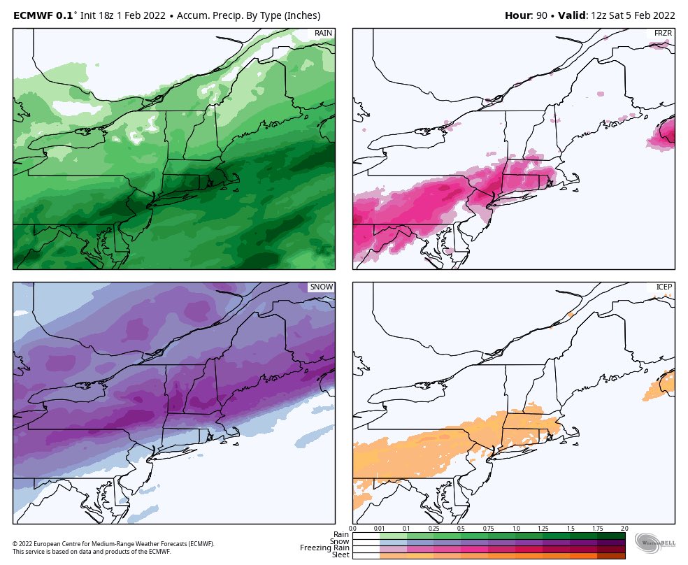
Great Map for Ice accretion- ZR


Look at that press - you do NOT underestimate the cold in the heart of winter with a deep snowpack in NE and Canada and a 1040 plus HP over Quebec with a 1040 to its WSW with -20's in Canada.
NWS is out to lunch in Upton...literally!
amugs- Advanced Forecaster - Mod

- Posts : 15093
Join date : 2013-01-07
heehaw453 likes this post
Re: Monitoring February 4th
![]() by CPcantmeasuresnow Tue Feb 01, 2022 2:37 pm
by CPcantmeasuresnow Tue Feb 01, 2022 2:37 pm
amugs wrote:Food for thought from Earthlight at 33 n Rain:
Completely agree and if one is going to use precip maps in a mixed event like this could be, IMO, one has to use three maps to get a sense of what's actually going to happen:
For pure snowfall, use the Pivotal snowfall map
For pure freezing rain accretion, use the Pivotal freezing rain map (understanding that that is converting all rain falling at <32F as accreting freezing rain, which is a worst case)
For sleet, take the Tidbits "snowfall" map (which includes sleet as 10:1 snow), and kind of manually subtract out the pure snowfall from Pivotal and then divide that resulting "snowfall" (sleet) by 3 to get the sleet accumulation (given the roughly 3:1 frozen/liquid ratio for sleet vs. 10:1 for snow). Actual sleet maps would be nice, since clearly that TT "snowfall" map is mostly sleet at a much lower ratio.
It was in the last four years mugs although I can’t remember exactly which storm. We received 4 1/2 inches of sleet in Orange County And it was like shoveling a stack of 100 pound dumbbells. It fell on top of an already existing snow pack and that layer of sleet lasted for several weeks. That stuff has a real resilience to sun and rain. For someone like myself that loves the snow cover through most of the winter it’s the best once you get it off your driveway.

CPcantmeasuresnow- Wx Statistician Guru

- Posts : 7274
Reputation : 230
Join date : 2013-01-07
Age : 103
Location : Eastern Orange County, NY
Re: Monitoring February 4th
![]() by TheAresian Tue Feb 01, 2022 2:37 pm
by TheAresian Tue Feb 01, 2022 2:37 pm
As far as websites go, I have no idea what they're looking at. Accuweather has me getting .5-1" of ice when even the NAM has taken me out of the frozen zone at this stage. TWC has 10 hours of 36* and snow. Joe Bastardi uses the Crapola model for his twitter and that says 14-16". It makes me so thankful for this forum and the people on it that make the weather make sense. Even on the missed forecasts there's a postmortem that breaks down what happened.
TheAresian- Senior Enthusiast
- Posts : 145
Reputation : 10
Join date : 2019-11-13
Location : Painted Post, NY
Re: Monitoring February 4th
![]() by rb924119 Tue Feb 01, 2022 3:17 pm
by rb924119 Tue Feb 01, 2022 3:17 pm
Those who do see the ice, which I still like my zone from yesterday, will see a fair bit of it, but I think NW NJ, NEPA, and the Hudson Valley will be pleasantly “surprised” by the snowfall totals here, as Warning criteria should be met VERY easily.
rb924119- Meteorologist

- Posts : 6890
Reputation : 194
Join date : 2013-02-06
Age : 32
Location : Greentown, Pa
Re: Monitoring February 4th
![]() by jmanley32 Tue Feb 01, 2022 3:25 pm
by jmanley32 Tue Feb 01, 2022 3:25 pm
Looks like by GFS and Euro I should prepare for quite a frz event, one that maybe we have not seen in my memory anyways. Euro map mugs posted shows 0.34 for yonkers on euro and GFS is a inch so would you say it is reasonable to prepare for somewhere between there? I hope the NAM can clear this up as hi res sometimes does better with the frz. I do wish I was going to see the snow but either way safety wise I am home friday. This comes in the morning and is out by evening?rb924119 wrote:As of now, I still like my initial ideas on this system, and expect us to see this continue trending south. GFS should lead the way here, with respect to both the southward trend and the narrowing field of icing. However, I’d like to clarify this a bit. I don’t that the actual wave of low pressure will change much in it’s depicted latitude. BUT, I think that we see the flow become more compressed over the Northeast as the northern stream runs out ahead while the southern stream lags behind, has more energy elongate over the Southwest, and end up as a weaker, more positively tilted trough. On top of that, this is a very steep, Arctic front *advancing thanks to the front running northern stream. It’s not cold air retreating in advance of precipitation/warm advection. Very big difference, and is why I see both a narrow band of icing, and more of a rain/freezing rain or snow situation, versus a smorgasbord of all three (though obviously there will be some sleet, just not a broad area).
Those who do see the ice, which I still like my zone from yesterday, will see a fair bit of it, but I think NW NJ, NEPA, and the Hudson Valley will be pleasantly “surprised” by the snowfall totals here, as Warning criteria should be met VERY easily.

jmanley32- Senior Enthusiast
- Posts : 20516
Reputation : 108
Join date : 2013-12-12
Age : 42
Location : Yonkers, NY
Re: Monitoring February 4th
![]() by aiannone Tue Feb 01, 2022 3:37 pm
by aiannone Tue Feb 01, 2022 3:37 pm
_________________
-Alex Iannone-

aiannone- Senior Enthusiast - Mod
- Posts : 4814
Reputation : 92
Join date : 2013-01-07
Location : Saint James, LI (Northwest Suffolk Co.)
Re: Monitoring February 4th
![]() by heehaw453 Tue Feb 01, 2022 3:40 pm
by heehaw453 Tue Feb 01, 2022 3:40 pm

heehaw453- Advanced Forecaster

- Posts : 3906
Reputation : 86
Join date : 2014-01-20
Location : Bedminster Township, PA Elevation 600' ASL
Re: Monitoring February 4th
![]() by SoulSingMG Tue Feb 01, 2022 4:28 pm
by SoulSingMG Tue Feb 01, 2022 4:28 pm


Last edited by SoulSingMG on Tue Feb 01, 2022 4:32 pm; edited 2 times in total

SoulSingMG- Senior Enthusiast
- Posts : 2853
Reputation : 74
Join date : 2013-12-11
Location : Long Island City, NY
Re: Monitoring February 4th
![]() by jimv45 Tue Feb 01, 2022 4:31 pm
by jimv45 Tue Feb 01, 2022 4:31 pm
jimv45- Senior Enthusiast
- Posts : 1168
Reputation : 36
Join date : 2013-09-20
Location : Hopewell jct.
Re: Monitoring February 4th
![]() by SoulSingMG Tue Feb 01, 2022 4:33 pm
by SoulSingMG Tue Feb 01, 2022 4:33 pm
jimv45 wrote:I am expecting a good amount of snow with some Sleet in my area! Just hope for no freezing rain.
I edited my post to most of us ;-)
SoulSingMG- Senior Enthusiast
- Posts : 2853
Reputation : 74
Join date : 2013-12-11
Location : Long Island City, NY
jimv45 likes this post
Re: Monitoring February 4th
![]() by hyde345 Tue Feb 01, 2022 4:50 pm
by hyde345 Tue Feb 01, 2022 4:50 pm
aiannone wrote:18z NAM much warmer. Rain into interior SNE. Direct result of weaker HP to the north and stronger first wave of energy
Nam has been abysmal beyond 48 hours. Will start taking it seriously tomorrow at 12z.

hyde345- Pro Enthusiast

- Posts : 1082
Reputation : 48
Join date : 2013-01-08
Location : Hyde Park, NY
Re: Monitoring February 4th
![]() by heehaw453 Tue Feb 01, 2022 5:11 pm
by heehaw453 Tue Feb 01, 2022 5:11 pm


heehaw453- Advanced Forecaster
- Posts : 3906
Reputation : 86
Join date : 2014-01-20
Location : Bedminster Township, PA Elevation 600' ASL
Re: Monitoring February 4th
![]() by TheAresian Tue Feb 01, 2022 5:19 pm
by TheAresian Tue Feb 01, 2022 5:19 pm
TheAresian- Senior Enthusiast
- Posts : 145
Reputation : 10
Join date : 2019-11-13
Location : Painted Post, NY
Re: Monitoring February 4th
![]() by jmanley32 Tue Feb 01, 2022 6:06 pm
by jmanley32 Tue Feb 01, 2022 6:06 pm
That moved the most Sig ice to north of me do u think that's case? I was in bullseye b4. I am go need my power Friday or I am go b in deep dodo. Should I be okay or should I take a trip somewhere it's less bad like in CT?heehaw453 wrote:New GFS looks reasonable to me and it's finally showing Boston not getting 17" of snow. I think the sig ice threat is I80 on northward with this one.
Last edited by jmanley32 on Tue Feb 01, 2022 7:24 pm; edited 1 time in total
jmanley32- Senior Enthusiast
- Posts : 20516
Reputation : 108
Join date : 2013-12-12
Age : 42
Location : Yonkers, NY
Re: Monitoring February 4th
![]() by jmanley32 Tue Feb 01, 2022 6:07 pm
by jmanley32 Tue Feb 01, 2022 6:07 pm
He meant up your way not for us joining the icecapadesTheAresian wrote:GFS has been consistent in that it batters a lot of you with ice. Hopefully, Ray is right when he says people will be pleasantly surprised with snowfall totals.
jmanley32- Senior Enthusiast
- Posts : 20516
Reputation : 108
Join date : 2013-12-12
Age : 42
Location : Yonkers, NY
Re: Monitoring February 4th
![]() by TheAresian Tue Feb 01, 2022 6:30 pm
by TheAresian Tue Feb 01, 2022 6:30 pm
TheAresian- Senior Enthusiast
- Posts : 145
Reputation : 10
Join date : 2019-11-13
Location : Painted Post, NY
amugs likes this post
Re: Monitoring February 4th
![]() by amugs Tue Feb 01, 2022 7:28 pm
by amugs Tue Feb 01, 2022 7:28 pm
Please keep this to model analysis, and maps.
I trust in Rb and believe it will be more snow in NNJ but after a good dose of ice. We've seen NW ticks then to have a SE ticks before the storm this year.
_________________
Mugs
AKA:King: Snow Weenie
Self Proclaimed
WINTER 2014-15 : 55.12" +.02 for 6 coatings (avg. 35")
WINTER 2015-16 Total - 29.8" (Avg 35")
WINTER 2016-17 : 39.5" so far

amugs- Advanced Forecaster - Mod
- Posts : 15093
Reputation : 213
Join date : 2013-01-07
Age : 54
Location : Hillsdale,NJ
Re: Monitoring February 4th
![]() by amugs Tue Feb 01, 2022 7:31 pm
by amugs Tue Feb 01, 2022 7:31 pm
That is a boat load of ice for NNJ and LHV.
_________________
Mugs
AKA:King: Snow Weenie
Self Proclaimed
WINTER 2014-15 : 55.12" +.02 for 6 coatings (avg. 35")
WINTER 2015-16 Total - 29.8" (Avg 35")
WINTER 2016-17 : 39.5" so far
amugs- Advanced Forecaster - Mod
- Posts : 15093
Reputation : 213
Join date : 2013-01-07
Age : 54
Location : Hillsdale,NJ
Re: Monitoring February 4th
![]() by amugs Tue Feb 01, 2022 8:52 pm
by amugs Tue Feb 01, 2022 8:52 pm
PA/NJ/NY/CT
— Mike Masco (@MikeMasco) February 2, 2022
I think there's two area's of support. Major event for NNJ/CT/southern MA/ Lower Hudson Valley into central PA. Zone 2 is Central MD where cold air can easily funnel south in the beltways pic.twitter.com/t86P7VPAT4
_________________
Mugs
AKA:King: Snow Weenie
Self Proclaimed
WINTER 2014-15 : 55.12" +.02 for 6 coatings (avg. 35")
WINTER 2015-16 Total - 29.8" (Avg 35")
WINTER 2016-17 : 39.5" so far
amugs- Advanced Forecaster - Mod
- Posts : 15093
Reputation : 213
Join date : 2013-01-07
Age : 54
Location : Hillsdale,NJ
Re: Monitoring February 4th
![]() by amugs Tue Feb 01, 2022 9:02 pm
by amugs Tue Feb 01, 2022 9:02 pm

_________________
Mugs
AKA:King: Snow Weenie
Self Proclaimed
WINTER 2014-15 : 55.12" +.02 for 6 coatings (avg. 35")
WINTER 2015-16 Total - 29.8" (Avg 35")
WINTER 2016-17 : 39.5" so far
amugs- Advanced Forecaster - Mod
- Posts : 15093
Reputation : 213
Join date : 2013-01-07
Age : 54
Location : Hillsdale,NJ
Re: Monitoring February 4th
![]() by jmanley32 Tue Feb 01, 2022 9:10 pm
by jmanley32 Tue Feb 01, 2022 9:10 pm
what run is that showing of what model? If there is a inch of ice here in yonkers it will be a disaster moreso than other places I will explain why, we are the san francisco of the east coast we have many hills that in snow you cannot get up some near 70% incline. They should shut the city down if this were to transpire. Which is looking more and more likely, and clearly going to eastern CT won't help me any better as its showing at least a half inch there too. I pray I keep my power Friday, I have a virtual training required for work that will not be repeated on a new therapy model for treatment for substance abusing teens/young adults with mental health diagnosis.amugs wrote:PA/NJ/NY/CT
— Mike Masco (@MikeMasco) February 2, 2022
I think there's two area's of support. Major event for NNJ/CT/southern MA/ Lower Hudson Valley into central PA. Zone 2 is Central MD where cold air can easily funnel south in the beltways pic.twitter.com/t86P7VPAT4
For those that do not know which I did not lower hudson valley is considered rockland and westchester counties so we are in the crosshairs of this nastiness.
jmanley32- Senior Enthusiast
- Posts : 20516
Reputation : 108
Join date : 2013-12-12
Age : 42
Location : Yonkers, NY
Re: Monitoring February 4th
![]() by jmanley32 Tue Feb 01, 2022 9:30 pm
by jmanley32 Tue Feb 01, 2022 9:30 pm
jmanley32- Senior Enthusiast
- Posts : 20516
Reputation : 108
Join date : 2013-12-12
Age : 42
Location : Yonkers, NY
Re: Monitoring February 4th
![]() by aiannone Tue Feb 01, 2022 10:05 pm
by aiannone Tue Feb 01, 2022 10:05 pm

_________________
-Alex Iannone-
aiannone- Senior Enthusiast - Mod
- Posts : 4814
Reputation : 92
Join date : 2013-01-07
Location : Saint James, LI (Northwest Suffolk Co.)
Re: Monitoring February 4th
![]() by Dunnzoo Tue Feb 01, 2022 10:05 pm
by Dunnzoo Tue Feb 01, 2022 10:05 pm
_________________
Janet
Snowfall winter of 2023-2024 17.5"
Snowfall winter of 2022-2023 6.0"
Snowfall winter of 2021-2022 17.6" 1" sleet 2/25/22
Snowfall winter of 2020-2021 51.1"
Snowfall winter of 2019-2020 8.5"
Snowfall winter of 2018-2019 25.1"
Snowfall winter of 2017-2018 51.9"
Snowfall winter of 2016-2017 45.6"
Snowfall winter of 2015-2016 29.5"
Snowfall winter of 2014-2015 50.55"
Snowfall winter of 2013-2014 66.5"

Dunnzoo- Senior Enthusiast - Mod
- Posts : 4891
Reputation : 68
Join date : 2013-01-11
Age : 62
Location : Westwood, NJ
jmanley32 likes this post
Re: Monitoring February 4th
![]() by amugs Tue Feb 01, 2022 10:22 pm
by amugs Tue Feb 01, 2022 10:22 pm
NAM is on board. No two ways about it.
It's the heart of winter with a deep snowpack overhead and a moderate/ strong HP to very strong HP.
This set up is who gets how much IMO and looking at analogs.
I pray

_________________
Mugs
AKA:King: Snow Weenie
Self Proclaimed
WINTER 2014-15 : 55.12" +.02 for 6 coatings (avg. 35")
WINTER 2015-16 Total - 29.8" (Avg 35")
WINTER 2016-17 : 39.5" so far
amugs- Advanced Forecaster - Mod
- Posts : 15093
Reputation : 213
Join date : 2013-01-07
Age : 54
Location : Hillsdale,NJ
Re: Monitoring February 4th
![]() by amugs Tue Feb 01, 2022 10:23 pm
by amugs Tue Feb 01, 2022 10:23 pm

_________________
Mugs
AKA:King: Snow Weenie
Self Proclaimed
WINTER 2014-15 : 55.12" +.02 for 6 coatings (avg. 35")
WINTER 2015-16 Total - 29.8" (Avg 35")
WINTER 2016-17 : 39.5" so far
amugs- Advanced Forecaster - Mod
- Posts : 15093
Reputation : 213
Join date : 2013-01-07
Age : 54
Location : Hillsdale,NJ
Page 4 of 13 • 1, 2, 3, 4, 5 ... 11, 12, 13 ![]()
|
|
|