Long Range Thread 26.0
+20
Grselig
hyde345
billg315
jmanley32
dkodgis
Quietace
crippo84
SoulSingMG
Carvin
SENJsnowman
chief7
nutleyblizzard
lglickman1
CPcantmeasuresnow
phil155
Radz
heehaw453
sroc4
amugs
Frank_Wx
24 posters
Page 2 of 6 •  1, 2, 3, 4, 5, 6
 Re: Long Range Thread 26.0
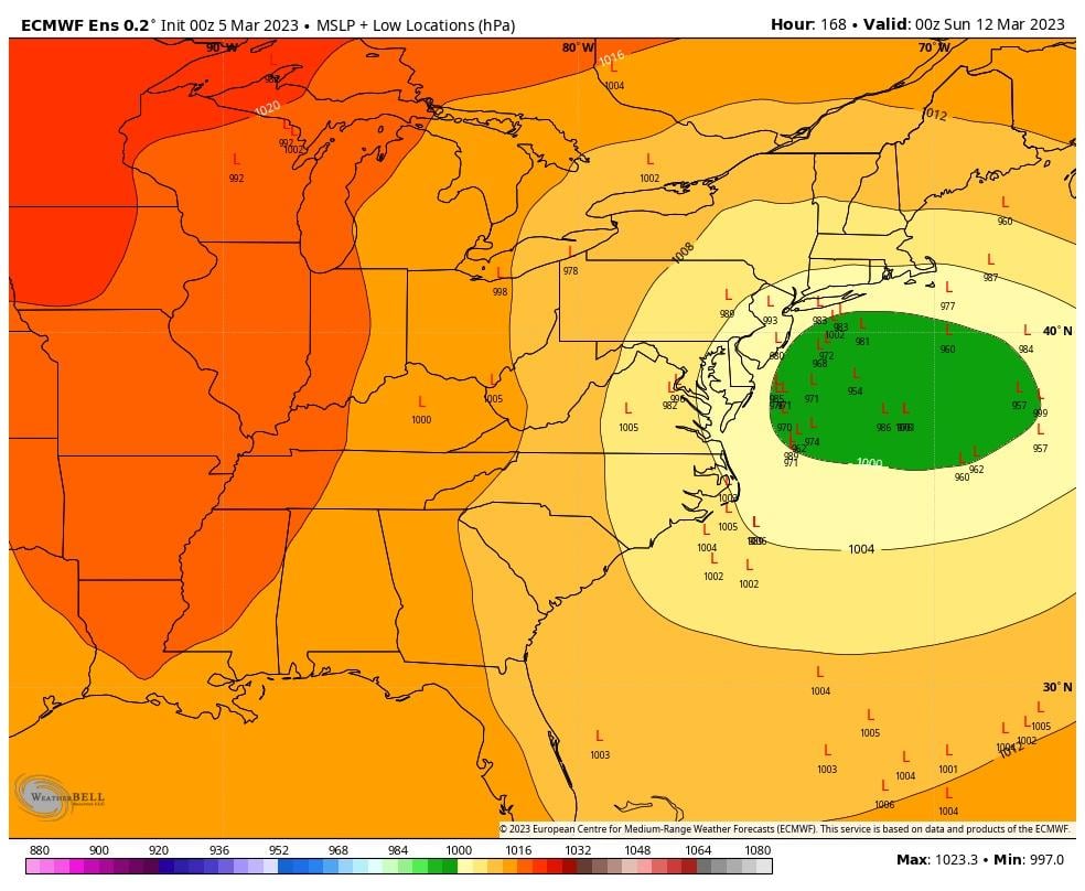
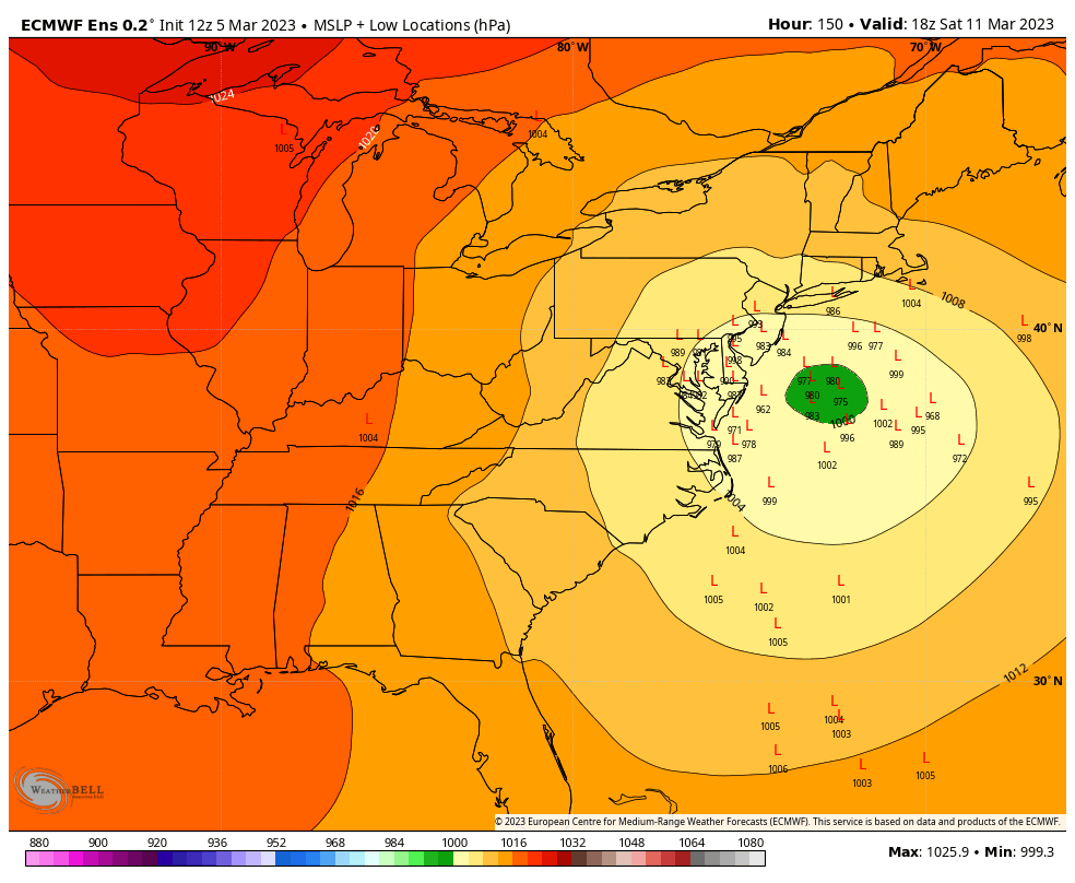
EURO with massive changes last night. The trough out west is much weaker and opens up at OZ allowing the SW to cut underneath the block which results in a strong coastal low. The OP showed a two footer, and the EPS that followed shows a lot of big hits as we well. The GFS and GEFS while not showing this wild scenario as of now, did show some baby steps towards the EURO idea.
nutleyblizzard- Senior Enthusiast

- Posts : 1952
Join date : 2014-01-30
 Re: Long Range Thread 26.0
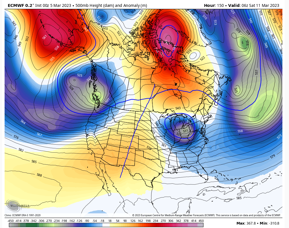
Nice write up. The Euro has been somewhat consistent at the h5 IMO. The s/w gets ejected out of the PAC as a wave break and moves along. It's the ridge behind the s/w that is somewhat in question. More defined ridge probably means a much stronger storm that will dive under us instead of want to reform like what it showed yesterday. the reform scenario is much less potent for our area.nutleyblizzard wrote:
EURO with massive changes last night. The trough out west is much weaker and opens up at OZ allowing the SW to cut underneath the block which results in a strong coastal low. The OP showed a two footer, and the EPS that followed shows a lot of big hits as we well. The GFS and GEFS while not showing this wild scenario as of now, did show some baby steps towards the EURO idea.
The key to this storm is right here IMO in the PNA. The other features I'm feeling good about NAO/Atlantic trough. Let's hope.
heehaw453- Advanced Forecaster

- Posts : 3906
Join date : 2014-01-20
 Re: Long Range Thread 26.0
it seems like an eternity since that last time i saw the Euro show snowfall rates like what 00Z showed last night. made possible with PNA and NAO/Atlantic working hand in hand. that's the key to this one dual cooperation.
heehaw453- Advanced Forecaster

- Posts : 3906
Reputation : 86
Join date : 2014-01-20
Location : Bedminster Township, PA Elevation 600' ASL
heehaw453- Advanced Forecaster

- Posts : 3906
Reputation : 86
Join date : 2014-01-20
Location : Bedminster Township, PA Elevation 600' ASL
 Re: Long Range Thread 26.0
Sorry but I’m not buying into the GFS solution. Even though the last few cycles have gotten progressively weaker with the primary low, it continues to drive it into the block. Doesn’t make sense to me.

nutleyblizzard- Senior Enthusiast

- Posts : 1952
Reputation : 41
Join date : 2014-01-30
Age : 58
Location : Nutley, new jersey
 Re: Long Range Thread 26.0
Dani Beckstrom just showed the Euro for next weekend lol
Radz- Pro Enthusiast

- Posts : 1028
Reputation : 17
Join date : 2013-01-12
Location : Cortlandt Manor NY
 Re: Long Range Thread 26.0
Pardon me for the imby request, but do the southern Jersey types of the world need to be paying attention, or are we already locked in to the ol’ ‘wind and rain’ event down here?
SENJsnowman- Senior Enthusiast

- Posts : 1186
Reputation : 61
Join date : 2017-01-06
Age : 51
Location : Bayville, NJ
 Re: Long Range Thread 26.0
SENJsnowman wrote:Pardon me for the imby request, but do the southern Jersey types of the world need to be paying attention, or are we already locked in to the ol’ ‘wind and rain’ event down here?
This early in the process anyone from the Mid Atlantic through the northeast is in play even the coast. Hopefully the setup with some blocking in place is different this time but we’ve seen a lot of threats 7 days out this year and they all seem to fade by day 4-5. Maybe this time is different but I wouldn’t hold my breath either.

CPcantmeasuresnow- Wx Statistician Guru

- Posts : 7274
Reputation : 230
Join date : 2013-01-07
Age : 103
Location : Eastern Orange County, NY
 Re: Long Range Thread 26.0
CPcantmeasuresnow wrote:SENJsnowman wrote:Pardon me for the imby request, but do the southern Jersey types of the world need to be paying attention, or are we already locked in to the ol’ ‘wind and rain’ event down here?
This early in the process anyone from the Mid Atlantic through the northeast is in play even the coast. Hopefully the setup with some blocking in place is different this time but we’ve seen a lot of threats 7 days out this year and they all seem to fade by day 4-5. Maybe this time is different but I wouldn’t hold my breath either.
Agreed
_________________
"In weather and in life, there's no winning and losing; there's only winning and learning."
WINTER 2012/2013 TOTALS 43.65"WINTER 2017/2018 TOTALS 62.85" WINTER 2022/2023 TOTALS 4.9"
WINTER 2013/2014 TOTALS 64.85"WINTER 2018/2019 TOTALS 14.25" WINTER 2023/2024 TOTALS 13.1"
WINTER 2014/2015 TOTALS 71.20"WINTER 2019/2020 TOTALS 6.35"
WINTER 2015/2016 TOTALS 35.00"WINTER 2020/2021 TOTALS 37.75"
WINTER 2016/2017 TOTALS 42.25"WINTER 2021/2022 TOTALS 31.65"

sroc4- Admin

- Posts : 8331
Reputation : 301
Join date : 2013-01-07
Location : Wading River, LI
sroc4 and CPcantmeasuresnow like this post
 Re: Long Range Thread 26.0
Thank you and Woo hoo! This early in the process, that’s I needed to hear!!
SENJsnowman- Senior Enthusiast

- Posts : 1186
Reputation : 61
Join date : 2017-01-06
Age : 51
Location : Bayville, NJ
CPcantmeasuresnow likes this post
 Re: Long Range Thread 26.0
Dont look too much beyond the next 3-5days on the operational runs. Obv beyond 4-6days out the ensembles will likely give a better idea as to where things are headed, as the operational runs have way too much variability and volatility from run to run at that lead time; esp with such a complex and potentially high impact storm potential. That said there are a few things right in front of us, beginning at around the 3day mark, that will be critical to the outcome and evaluating the operational models is going to be my preference for this.
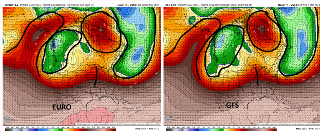
Lets look. This first image represents the 500mb pattern about 3days out, (approx Wednesday 1am). More than reasonable to be looking at op runs. Take notice by the areas Ive highlighted that for the most part both euro and GFS have the big picture pretty much similar. This is where the forecasts diverge in the modeling right now. I want you to take particular notice to the WC of Canada and NW coast of the CONUS.
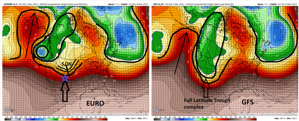
Fast forward about Thursday am 10am. Now look along the WC of Canada. There are three key differences that are critically important.
1) First: Look at the ridging on the left side of both images. Notice how far north the ridge extends into Alaska on the Euro when compared to the GFS.
2&3) Second and third: The euro wants to back an ULL just off the NW Coast line and break off a piece of energy from the mean trough and eject it out separate from the mean trough in the form of a short wave(S/W). GFS, on the other hand, keeps all energy as one complex in the form of a full latitude trough.
As we fast forward again to about 1pm Friday afternoon in the forecast now the differences at 500mb have become really apparent. On the Euro the ULL that hangs back off the WC, the shortwave ejecting east, and the space between the two, allows a subtle positive to neutral PNA ridge to emerge. This subtle ridging to the west of our system is what will allow the S/W to maintain a more eastward trajectory and allow it to run into the confluence created by our congested Atlantic as depicted on this Euro run. (-NAO and 50/50 low complex that has become well established over the past week and a half)
Because the GFS; however, maintains a large complex full lat trough, the PNA remains in a mod to strong negative state allowing the complex to amplify the SE ridge which allows it to force the main energy well N into Canada instead of forcing the energy E into the confluence and off the EC like the euro.

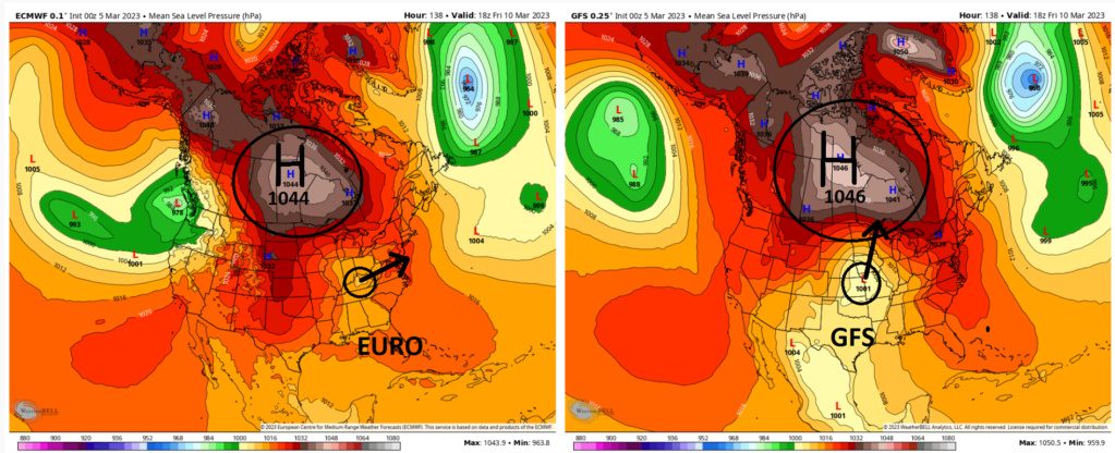
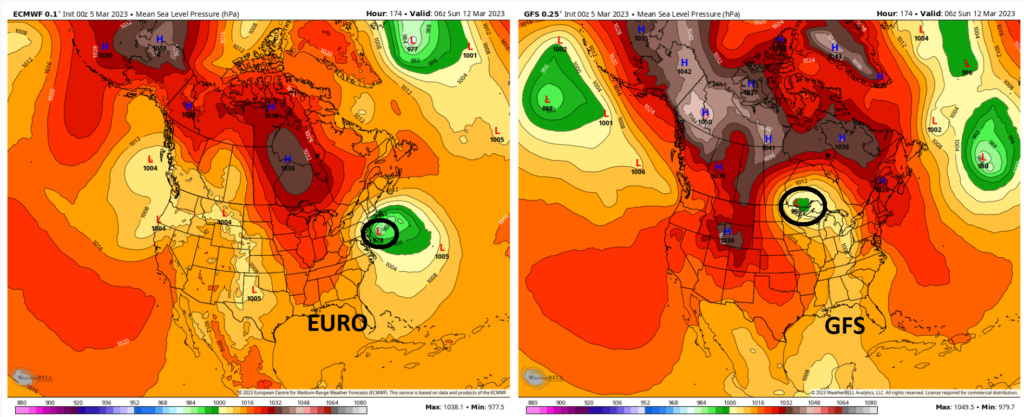
Im sorry GFS I have a really hard time believing that that surface low will bully its way into a 1046HP and make it that far north. Personally I think the GFS will correct towards the euro for a number of reasons.
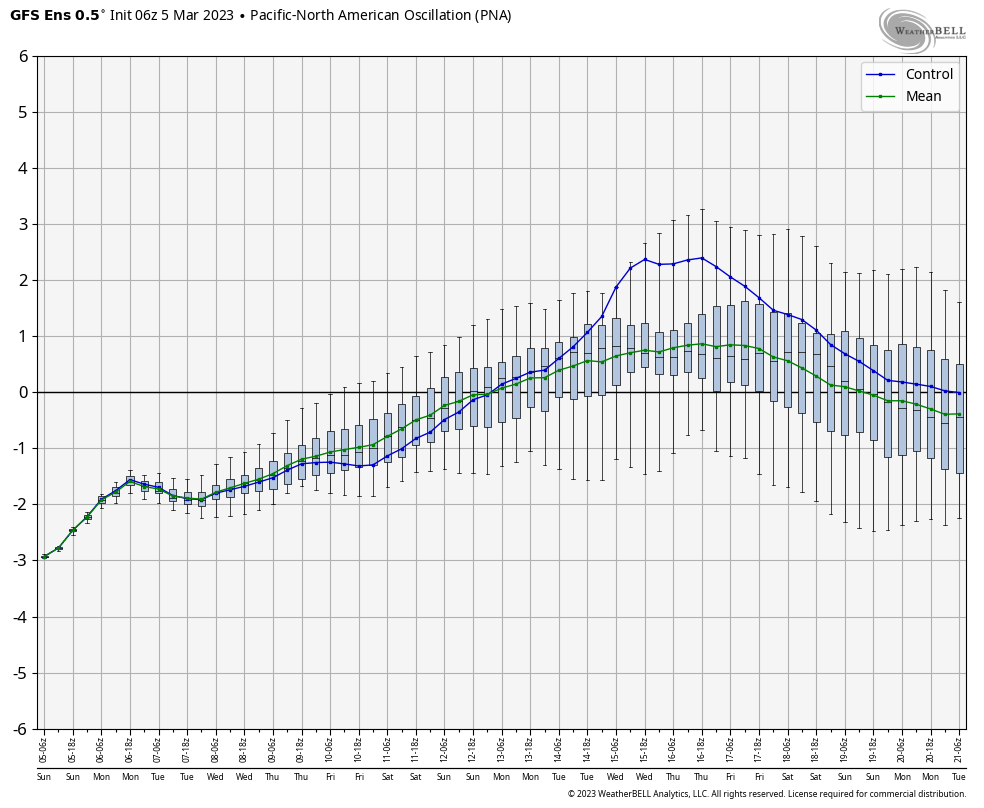
First The GFS Ens PNA forecast is at odds with its operational depiction of the PNA region for this timeframe. This graph shows the GFS ens PNA is coming towards neutral to positive.(Euro ens forcast graph is very similar to this one. The operational forecast I am showing above is depicting a PNA that becomes more negative as the week progresses. Both cant be right.
Second as mentioned above there has been an established blocking pattern in the N Atlantic compliments of the -NAO and 50/50 Low complex which has been allowed to take shape in large part due to the Strat warming that took place last month. Go back to prev discussions to see those details. The Atlantic blocking complex has been in place now for over a week.
Let's look to the Pacific forcing mechanisms for the third point that makes me think colder solns will win. As has been discussed for both last Monday Tuesday system that did work for most, as well as yesterdays system that didn't, the SOI and the MJO(pacific forcing indicators) have played a big role in how the down stream pattern over north America played out. Both appear to be aligning such that as this system traverses the CONUS this week and approaches the EC is such that we appear to be in more favorable position for the colder outcome.
The SOI has been neutral to negative/neutral for the past few days: https://www.longpaddock.qld.gov.au/soi/
This should be an indicator that the potential strength at which the background La Nina can influence the down stream pattern, ala the SE ridge, will be somewhat mediated. Ideally we get a few stronger negative values over the next several days. This would make me feel a little better about that, but for now Ill take neutral.
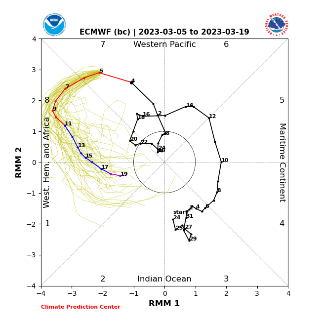
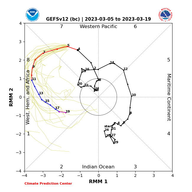
The MJO however appears it WILL BE in a FAVORABLE phase 8 WITH amplitude as we head through the week. The early week storm the MJO was basically non existent, so it neither hurt nor helped a lot IMHO, but we had several days in a fairly moderate-strong negative SOI state which helped re-enforce our Atlantic blocking complex. That combined with the strat warming details we discussed as well. This time, however, this phase 8 MJO wave "should" HELP tremendously trigger a push in the atmosphere downstream to the colder solns.
So to summarize beyond day 3 the GFS and Euro diverge in the evolution of the 500mb pattern in a drastic way. As outlined below I believe a trend towards a colder soln, ie one that forces our primary to transfer off the EC south of LI is more likely than one that passes the Low N of LI. That said we are still too far out to exclude anything at this point. Snowman and to all the S jersey and coastal folks, WE ARE ALL STILL IN THE GAME, but we must remember these set ups always favor the N&W folks. Location location location....500mb features, surface features and everything in between.
So buckle up folks, because over the next few days we should begin to see which direction the models take. Again don't just jump straight to what the surface soln looks like for Sat to Sun. Focus on the 500mb maps beginning Wednesday-Friday as I outlined above. This will tell you what the surface maps will likely look like for the weekend.............
WE TRACK!!!!
Lets look. This first image represents the 500mb pattern about 3days out, (approx Wednesday 1am). More than reasonable to be looking at op runs. Take notice by the areas Ive highlighted that for the most part both euro and GFS have the big picture pretty much similar. This is where the forecasts diverge in the modeling right now. I want you to take particular notice to the WC of Canada and NW coast of the CONUS.

Fast forward about Thursday am 10am. Now look along the WC of Canada. There are three key differences that are critically important.
1) First: Look at the ridging on the left side of both images. Notice how far north the ridge extends into Alaska on the Euro when compared to the GFS.
2&3) Second and third: The euro wants to back an ULL just off the NW Coast line and break off a piece of energy from the mean trough and eject it out separate from the mean trough in the form of a short wave(S/W). GFS, on the other hand, keeps all energy as one complex in the form of a full latitude trough.

As we fast forward again to about 1pm Friday afternoon in the forecast now the differences at 500mb have become really apparent. On the Euro the ULL that hangs back off the WC, the shortwave ejecting east, and the space between the two, allows a subtle positive to neutral PNA ridge to emerge. This subtle ridging to the west of our system is what will allow the S/W to maintain a more eastward trajectory and allow it to run into the confluence created by our congested Atlantic as depicted on this Euro run. (-NAO and 50/50 low complex that has become well established over the past week and a half)
Because the GFS; however, maintains a large complex full lat trough, the PNA remains in a mod to strong negative state allowing the complex to amplify the SE ridge which allows it to force the main energy well N into Canada instead of forcing the energy E into the confluence and off the EC like the euro.


Im sorry GFS I have a really hard time believing that that surface low will bully its way into a 1046HP and make it that far north. Personally I think the GFS will correct towards the euro for a number of reasons.
First The GFS Ens PNA forecast is at odds with its operational depiction of the PNA region for this timeframe. This graph shows the GFS ens PNA is coming towards neutral to positive.(Euro ens forcast graph is very similar to this one. The operational forecast I am showing above is depicting a PNA that becomes more negative as the week progresses. Both cant be right.

Second as mentioned above there has been an established blocking pattern in the N Atlantic compliments of the -NAO and 50/50 Low complex which has been allowed to take shape in large part due to the Strat warming that took place last month. Go back to prev discussions to see those details. The Atlantic blocking complex has been in place now for over a week.
Let's look to the Pacific forcing mechanisms for the third point that makes me think colder solns will win. As has been discussed for both last Monday Tuesday system that did work for most, as well as yesterdays system that didn't, the SOI and the MJO(pacific forcing indicators) have played a big role in how the down stream pattern over north America played out. Both appear to be aligning such that as this system traverses the CONUS this week and approaches the EC is such that we appear to be in more favorable position for the colder outcome.
The SOI has been neutral to negative/neutral for the past few days: https://www.longpaddock.qld.gov.au/soi/
This should be an indicator that the potential strength at which the background La Nina can influence the down stream pattern, ala the SE ridge, will be somewhat mediated. Ideally we get a few stronger negative values over the next several days. This would make me feel a little better about that, but for now Ill take neutral.
The MJO however appears it WILL BE in a FAVORABLE phase 8 WITH amplitude as we head through the week. The early week storm the MJO was basically non existent, so it neither hurt nor helped a lot IMHO, but we had several days in a fairly moderate-strong negative SOI state which helped re-enforce our Atlantic blocking complex. That combined with the strat warming details we discussed as well. This time, however, this phase 8 MJO wave "should" HELP tremendously trigger a push in the atmosphere downstream to the colder solns.


So to summarize beyond day 3 the GFS and Euro diverge in the evolution of the 500mb pattern in a drastic way. As outlined below I believe a trend towards a colder soln, ie one that forces our primary to transfer off the EC south of LI is more likely than one that passes the Low N of LI. That said we are still too far out to exclude anything at this point. Snowman and to all the S jersey and coastal folks, WE ARE ALL STILL IN THE GAME, but we must remember these set ups always favor the N&W folks. Location location location....500mb features, surface features and everything in between.
So buckle up folks, because over the next few days we should begin to see which direction the models take. Again don't just jump straight to what the surface soln looks like for Sat to Sun. Focus on the 500mb maps beginning Wednesday-Friday as I outlined above. This will tell you what the surface maps will likely look like for the weekend.............
WE TRACK!!!!

_________________
"In weather and in life, there's no winning and losing; there's only winning and learning."
WINTER 2012/2013 TOTALS 43.65"WINTER 2017/2018 TOTALS 62.85" WINTER 2022/2023 TOTALS 4.9"
WINTER 2013/2014 TOTALS 64.85"WINTER 2018/2019 TOTALS 14.25" WINTER 2023/2024 TOTALS 13.1"
WINTER 2014/2015 TOTALS 71.20"WINTER 2019/2020 TOTALS 6.35"
WINTER 2015/2016 TOTALS 35.00"WINTER 2020/2021 TOTALS 37.75"
WINTER 2016/2017 TOTALS 42.25"WINTER 2021/2022 TOTALS 31.65"

sroc4- Admin

- Posts : 8331
Reputation : 301
Join date : 2013-01-07
Location : Wading River, LI
CPcantmeasuresnow, Radz, kalleg, Grselig, dolphins222, essexcountypete, MattyICE and JT33 like this post
 Re: Long Range Thread 26.0
12z gfs now has the ULL off the WC and separate S/W come out and ultimately transfer off the coast. One run but step towards euro soln.
_________________
"In weather and in life, there's no winning and losing; there's only winning and learning."
WINTER 2012/2013 TOTALS 43.65"WINTER 2017/2018 TOTALS 62.85" WINTER 2022/2023 TOTALS 4.9"
WINTER 2013/2014 TOTALS 64.85"WINTER 2018/2019 TOTALS 14.25" WINTER 2023/2024 TOTALS 13.1"
WINTER 2014/2015 TOTALS 71.20"WINTER 2019/2020 TOTALS 6.35"
WINTER 2015/2016 TOTALS 35.00"WINTER 2020/2021 TOTALS 37.75"
WINTER 2016/2017 TOTALS 42.25"WINTER 2021/2022 TOTALS 31.65"

sroc4- Admin

- Posts : 8331
Reputation : 301
Join date : 2013-01-07
Location : Wading River, LI
CPcantmeasuresnow and heehaw453 like this post
 Re: Long Range Thread 26.0
This has classic nor’easter written all over it.
Carvin- Posts : 44
Reputation : 2
Join date : 2019-01-09
sroc4, CPcantmeasuresnow, essexcountypete and heehaw453 like this post
 Re: Long Range Thread 26.0
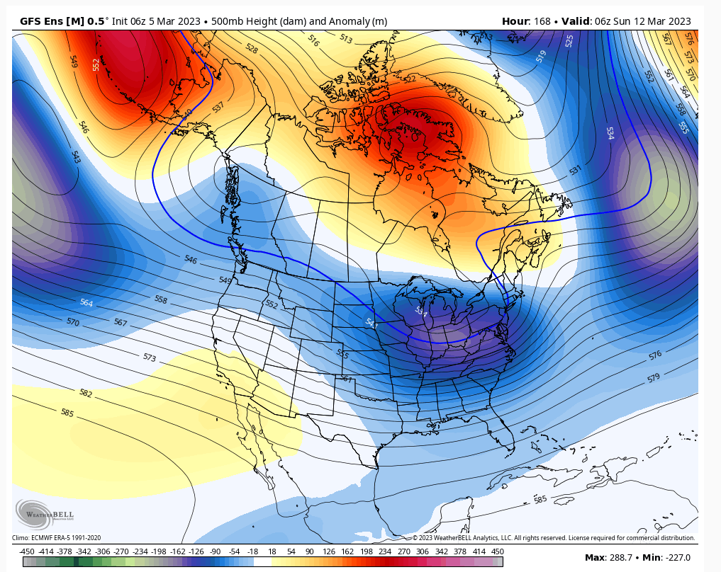
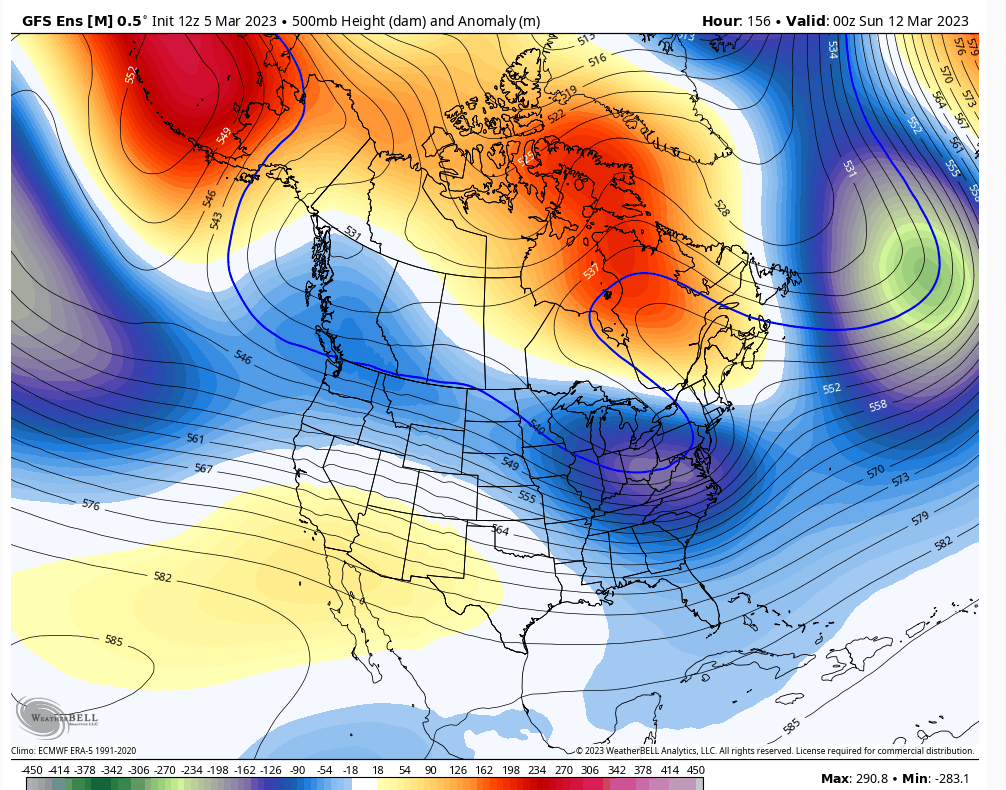
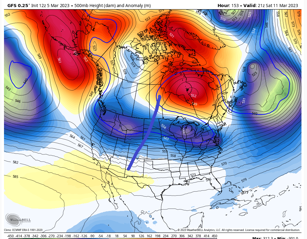
12Z GFS did make sig changes at the h5 as it breaks off the s/w, but it's ensembles have been showing that for last 3 cycles. i'm not concerned as much with that. If we want the big dog though there is going to need to be some PNA cooperation. There are hints of it on the modelling but that's the piece that is really up on in the air. This won't do it as shown. Sure we can get a decent hit for parts of the area with this but we need the ULL to rapidly blow up as it approaches the coast and that happens with PNA support. If i start to see ridge link up where I have the line then all bets are off with the ceiling of the storm.

heehaw453- Advanced Forecaster

- Posts : 3906
Reputation : 86
Join date : 2014-01-20
Location : Bedminster Township, PA Elevation 600' ASL
CPcantmeasuresnow likes this post
heehaw453- Advanced Forecaster

- Posts : 3906
Reputation : 86
Join date : 2014-01-20
Location : Bedminster Township, PA Elevation 600' ASL
sroc4 and CPcantmeasuresnow like this post
heehaw453- Advanced Forecaster

- Posts : 3906
Reputation : 86
Join date : 2014-01-20
Location : Bedminster Township, PA Elevation 600' ASL
CPcantmeasuresnow likes this post
heehaw453- Advanced Forecaster

- Posts : 3906
Reputation : 86
Join date : 2014-01-20
Location : Bedminster Township, PA Elevation 600' ASL
CPcantmeasuresnow, kalleg and MattyICE like this post

SoulSingMG- Senior Enthusiast

- Posts : 2853
Reputation : 74
Join date : 2013-12-11
Location : Long Island City, NY
 Re: Long Range Thread 26.0
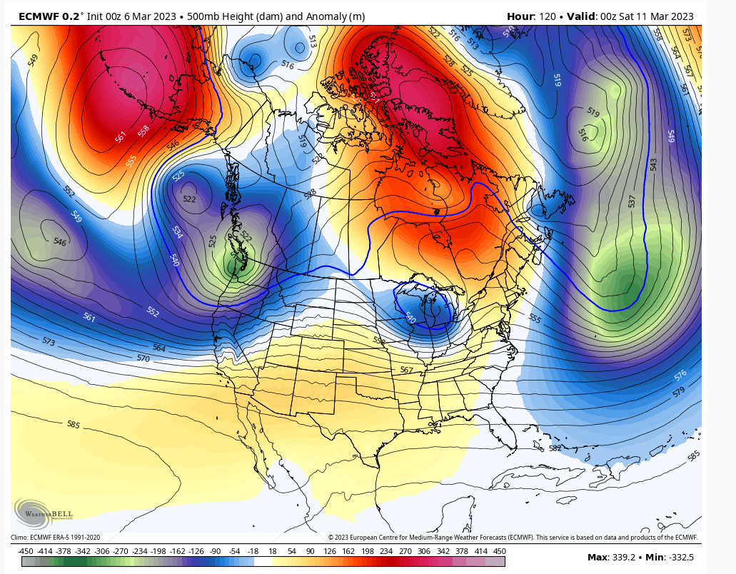
The ULL has to dig more in response to a ridge a bit further back west. Otherwise this won't have the time to do its magic. Wave spacing in March isn't the biggest concern like it is December/January, but it still needs to dig more. At D5 I'm not confident on much expect there's a threat window on Saturday.

heehaw453- Advanced Forecaster

- Posts : 3906
Reputation : 86
Join date : 2014-01-20
Location : Bedminster Township, PA Elevation 600' ASL
 Re: Long Range Thread 26.0
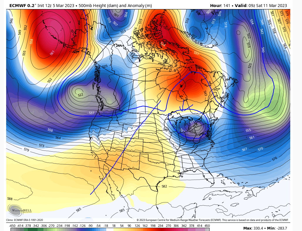
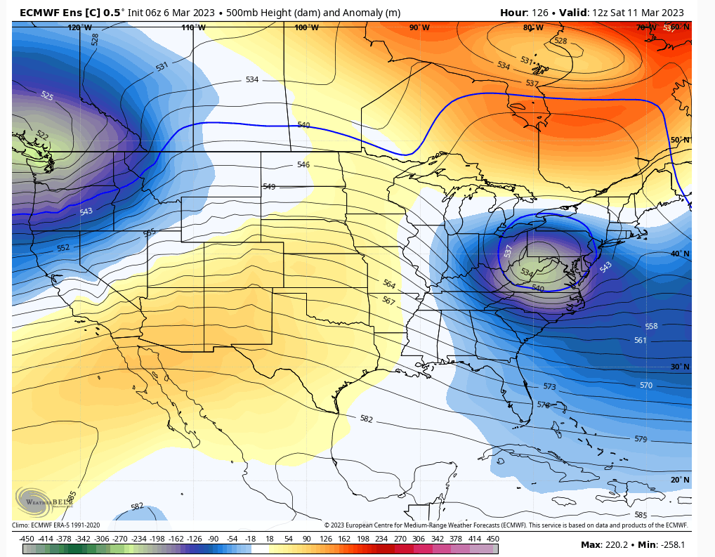
06Z Euro Control In case anyone thinks Saturday is set in stone. This scenario is in play where the ULL strengthens rapidly in response to western ridge and blocked up Atlantic. The exact timing of the strengthening and the influence of the block may be the difference between a minor event vs something epic.

heehaw453- Advanced Forecaster

- Posts : 3906
Reputation : 86
Join date : 2014-01-20
Location : Bedminster Township, PA Elevation 600' ASL
 Re: Long Range Thread 26.0
heehaw453 wrote:06Z Euro Control In case anyone thinks Saturday is set in stone. This scenario is in play where the ULL strengthens rapidly in response to western ridge and blocked up Atlantic. The exact timing of the strengthening and the influence of the block may be the difference between a minor event vs something epic.
I hope no one thinks Sat is set in stone 5-6days out.
_________________
"In weather and in life, there's no winning and losing; there's only winning and learning."
WINTER 2012/2013 TOTALS 43.65"WINTER 2017/2018 TOTALS 62.85" WINTER 2022/2023 TOTALS 4.9"
WINTER 2013/2014 TOTALS 64.85"WINTER 2018/2019 TOTALS 14.25" WINTER 2023/2024 TOTALS 13.1"
WINTER 2014/2015 TOTALS 71.20"WINTER 2019/2020 TOTALS 6.35"
WINTER 2015/2016 TOTALS 35.00"WINTER 2020/2021 TOTALS 37.75"
WINTER 2016/2017 TOTALS 42.25"WINTER 2021/2022 TOTALS 31.65"

sroc4- Admin

- Posts : 8331
Reputation : 301
Join date : 2013-01-07
Location : Wading River, LI
heehaw453 likes this post
heehaw453- Advanced Forecaster

- Posts : 3906
Reputation : 86
Join date : 2014-01-20
Location : Bedminster Township, PA Elevation 600' ASL
 Re: Long Range Thread 26.0
Don’t get too invested in OP runs right now as they will depict a different outcome then the one before. Pay attention to the H5 maps. The GFS improved nicely with the western ridge which resulted our SW low dig more. It’s all about the trends.

nutleyblizzard- Senior Enthusiast

- Posts : 1952
Reputation : 41
Join date : 2014-01-30
Age : 58
Location : Nutley, new jersey
sroc4, CPcantmeasuresnow, kalleg and SENJsnowman like this post
 Re: Long Range Thread 26.0
Great 12z suite thus far. The GFS, CMC and Ukie all show good improvements on the H5 maps. GEFS look very good as well.

nutleyblizzard- Senior Enthusiast

- Posts : 1952
Reputation : 41
Join date : 2014-01-30
Age : 58
Location : Nutley, new jersey
 Re: Long Range Thread 26.0
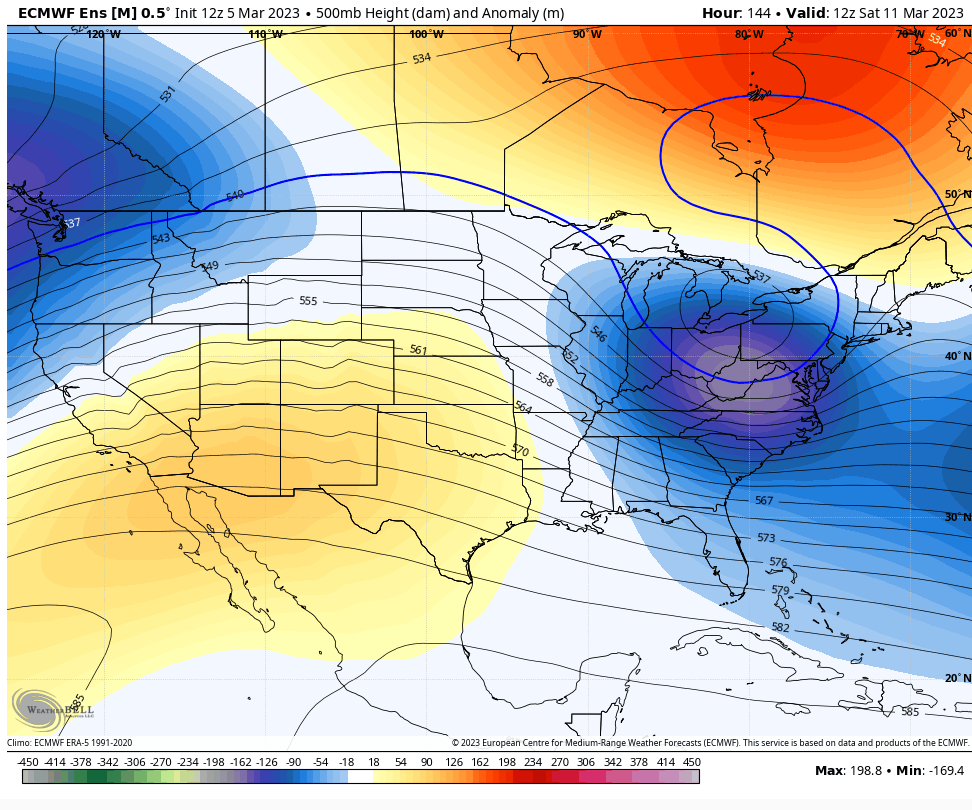
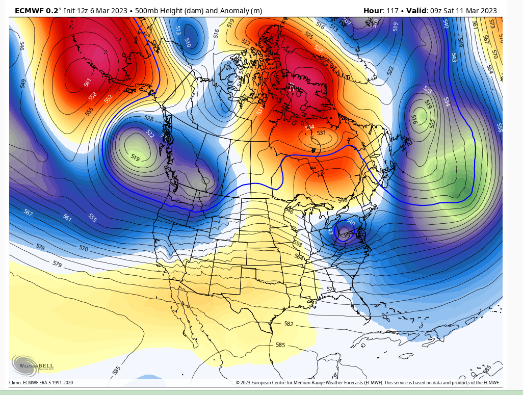
Euro 12Z.
Another fly in the ointment the Atlantic trough giving the ULL room to breathe. From perspective of the western ridge this run was just fine, but the Atlantic trough doesn't give it room to breathe as it approaches the coast and this run it disrupted its flow. This storm tonight will probably have an effect on that Atlantic trough w.r.t. to how strong it becomes. This why I truly appreciate the epic events when they occur. It all has to align.
Another fly in the ointment the Atlantic trough giving the ULL room to breathe. From perspective of the western ridge this run was just fine, but the Atlantic trough doesn't give it room to breathe as it approaches the coast and this run it disrupted its flow. This storm tonight will probably have an effect on that Atlantic trough w.r.t. to how strong it becomes. This why I truly appreciate the epic events when they occur. It all has to align.

heehaw453- Advanced Forecaster

- Posts : 3906
Reputation : 86
Join date : 2014-01-20
Location : Bedminster Township, PA Elevation 600' ASL
CPcantmeasuresnow likes this post
 Re: Long Range Thread 26.0
Reel it in guys, whatever might be biting at the end of the line. It's the bigger storm potentials that I learn the most from you all, even if they don't work out. Probably due to more excitement than the smaller events that are more of a nuisance than anything else. Even more so knowing that our window is coming to a close.

crippo84- Posts : 383
Reputation : 20
Join date : 2013-11-07
Age : 40
Location : East Village, NYC
kalleg and heehaw453 like this post
 Re: Long Range Thread 26.0
Two storm systems to watch. One this Saturday and another next Tuesday. Both have more potential to deliver widespread snow than any storm or threat we’ve seen yet this winter. That is because of the 500mb setup and presence of blocking. But my fear is the Pacific and whether we get it’s cooperation. Still too early to tell.
_________________
_______________________________________________________________________________________________________
CLICK HERE to view NJ Strong Snowstorm Classifications
Page 2 of 6 •  1, 2, 3, 4, 5, 6
Permissions in this forum:
You cannot reply to topics in this forum|
|
|

 Home
Home
