Long Range Thread 26.0
+20
Grselig
hyde345
billg315
jmanley32
dkodgis
Quietace
crippo84
SoulSingMG
Carvin
SENJsnowman
chief7
nutleyblizzard
lglickman1
CPcantmeasuresnow
phil155
Radz
heehaw453
sroc4
amugs
Frank_Wx
24 posters
Page 3 of 6 •  1, 2, 3, 4, 5, 6
 Re: Long Range Thread 26.0
Reel it in guys, whatever might be biting at the end of the line. It's the bigger storm potentials that I learn the most from you all, even if they don't work out. Probably due to more excitement than the smaller events that are more of a nuisance than anything else. Even more so knowing that our window is coming to a close.
crippo84- Posts : 383
Join date : 2013-11-07
kalleg and heehaw453 like this post
 Re: Long Range Thread 26.0
Two storm systems to watch. One this Saturday and another next Tuesday. Both have more potential to deliver widespread snow than any storm or threat we’ve seen yet this winter. That is because of the 500mb setup and presence of blocking. But my fear is the Pacific and whether we get it’s cooperation. Still too early to tell.
 Re: Long Range Thread 26.0
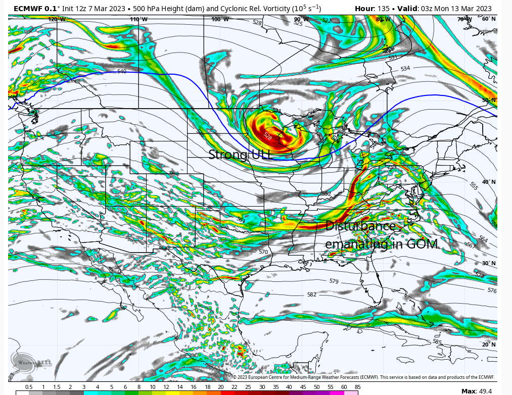
We're inside D5 now and time to pay attention to op models IMO. The Euro was close and I'm putting more weight on this than any other model. Think it's handled the pattern evolution better. The GFS is not doing a good job on this IMO.
If this can close off and deepen a few hours earlier then there will be an impact for good chunk of the area. Wave spacing with Atl trough will be critical. An ULL that closes off underneath you cannot be trusted as to what it will do.
If this can close off and deepen a few hours earlier then there will be an impact for good chunk of the area. Wave spacing with Atl trough will be critical. An ULL that closes off underneath you cannot be trusted as to what it will do.

heehaw453- Advanced Forecaster

- Posts : 3906
Reputation : 86
Join date : 2014-01-20
Location : Bedminster Township, PA Elevation 600' ASL
 Re: Long Range Thread 26.0
I think for the first time this winter, the EURO run last night showed a Godzilla coming up the coast next Tuesday


_________________
_______________________________________________________________________________________________________
CLICK HERE to view NJ Strong Snowstorm Classifications
JT33 likes this post
 Re: Long Range Thread 26.0
heehaw453 wrote:We're inside D5 now and time to pay attention to op models IMO. The Euro was close and I'm putting more weight on this than any other model. Think it's handled the pattern evolution better. The GFS is not doing a good job on this IMO.
If this can close off and deepen a few hours earlier then there will be an impact for good chunk of the area. Wave spacing with Atl trough will be critical. An ULL that closes off underneath you cannot be trusted as to what it will do.
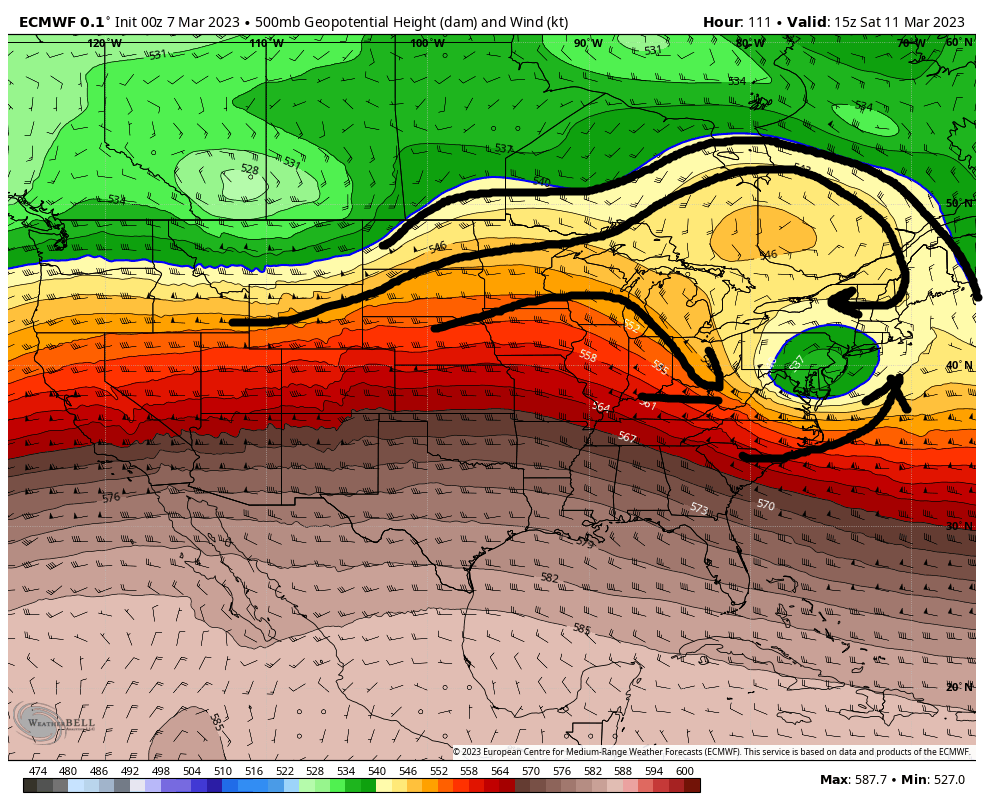
Quick update to piggyback off this. It seems both the euro and the GFS are in agreement in wanting our s/w to close off as it approaches the Ohio valley, be shunted ESE as it feels the effects of our Atlantic blocking, and track S&E of LI; however, one huge difference that will need sorting out is how much of a cold air source will there be to work with?
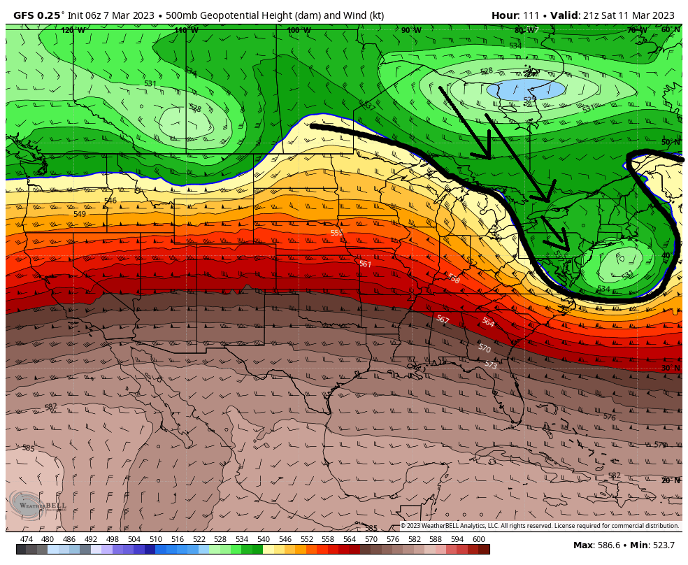
Take a quick peek at 500mb here. GFS, you can clearly see, interacts with the Polar jet allowing cold Canadian air mass to be involved as the ULL exits the coast S&E of Long Island.
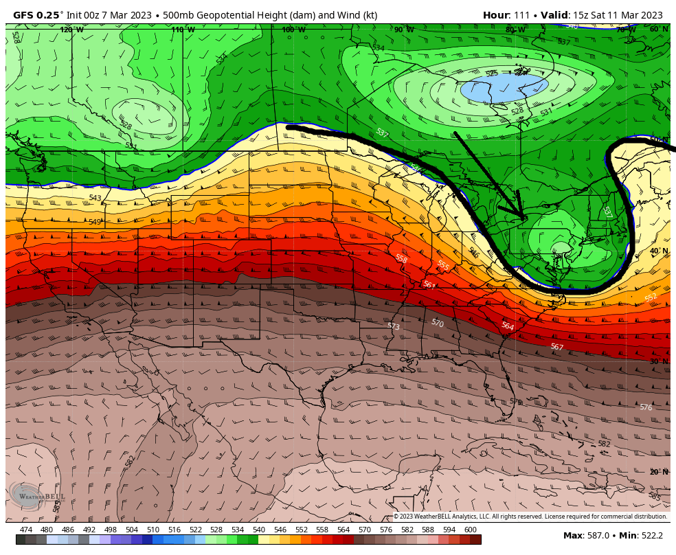
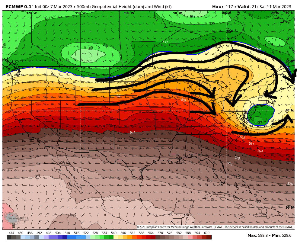
But the Euro clearly does not. It cuts off the ULL from the cold air source, and instead is only working with modified Pacific air mass.
The result on the surface is snow involved with the GFS(first image) and little to no Snow on the Euro(second image).
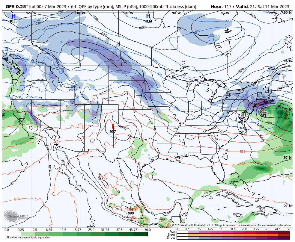

This VERY important difference needs to be sorted out. When looking it seems the differences between the two is only about 3-3.5 days out from now. Its at about this point where the GFS begins to link up with the Canadain air mass; whereas, the euro bulds the ridge over top linking it with the mini PNA ridge to the west of the system. So watch for trends within both models between 12z today and 12z tomorrow.
If we still cant work out interactions between jet streams inside3.5 days that tells me we still cant trust the exact track of the ULL just yet, which means surface LP track is even more unreliable. Again still some big picture items to work out before we work on surface details.
And yes behind the weekend system the Euro did show a beastly beast for Tuesday but undoubtedly the weekend system will play an important role in determining the set up for Tuesday's system. Fun times ahead for sure......
WE TRACK!!!

_________________
"In weather and in life, there's no winning and losing; there's only winning and learning."
WINTER 2012/2013 TOTALS 43.65"WINTER 2017/2018 TOTALS 62.85" WINTER 2022/2023 TOTALS 4.9"
WINTER 2013/2014 TOTALS 64.85"WINTER 2018/2019 TOTALS 14.25" WINTER 2023/2024 TOTALS 13.1"
WINTER 2014/2015 TOTALS 71.20"WINTER 2019/2020 TOTALS 6.35"
WINTER 2015/2016 TOTALS 35.00"WINTER 2020/2021 TOTALS 37.75"
WINTER 2016/2017 TOTALS 42.25"WINTER 2021/2022 TOTALS 31.65"

sroc4- Admin

- Posts : 8331
Reputation : 301
Join date : 2013-01-07
Location : Wading River, LI
crippo84, heehaw453, billg315, SENJsnowman and JT33 like this post
 Re: Long Range Thread 26.0
Very well put! I'm comfortable with the western ridge and the s/w trajectory in general up to the point of it hitting the coast, but it's the Atlantic trough that will either pull this ULL up or squash it. If it pulls it up that means it's linked up and it will deepen which will dynamically generate plenty of cold air at the mid-levels. IMO ATTM interior has the best shot at accumulating snow out of this one way or the other. That being said the coast can still get slammed with a GFS type solution.sroc4 wrote:heehaw453 wrote:We're inside D5 now and time to pay attention to op models IMO. The Euro was close and I'm putting more weight on this than any other model. Think it's handled the pattern evolution better. The GFS is not doing a good job on this IMO.
If this can close off and deepen a few hours earlier then there will be an impact for good chunk of the area. Wave spacing with Atl trough will be critical. An ULL that closes off underneath you cannot be trusted as to what it will do.
Quick update to piggyback off this. It seems both the euro and the GFS are in agreement in wanting our s/w to close off as it approaches the Ohio valley, be shunted ESE as it feels the effects of our Atlantic blocking, and track S&E of LI; however, one huge difference that will need sorting out is how much of a cold air source will there be to work with?
Take a quick peek at 500mb here. GFS, you can clearly see, interacts with the Polar jet allowing cold Canadian air mass to be involved as the ULL exits the coast S&E of Long Island.
But the Euro clearly does not. It cuts off the ULL from the cold air source, and instead is only working with modified Pacific air mass.
The result on the surface is snow involved with the GFS(first image) and little to no Snow on the Euro(second image).
This VERY important difference needs to be sorted out. When looking it seems the differences between the two is only about 3-3.5 days out from now. Its at about this point where the GFS begins to link up with the Canadain air mass; whereas, the euro bulds the ridge over top linking it with the mini PNA ridge to the west of the system. So watch for trends within both models between 12z today and 12z tomorrow.
If we still cant work out interactions between jet streams inside3.5 days that tells me we still cant trust the exact track of the ULL just yet, which means surface LP track is even more unreliable. Again still some big picture items to work out before we work on surface details.
And yes behind the weekend system the Euro did show a beastly beast for Tuesday but undoubtedly the weekend system will play an important role in determining the set up for Tuesday's system. Fun times ahead for sure......
WE TRACK!!!
heehaw453- Advanced Forecaster

- Posts : 3906
Reputation : 86
Join date : 2014-01-20
Location : Bedminster Township, PA Elevation 600' ASL
sroc4, billg315 and SENJsnowman like this post
 Re: Long Range Thread 26.0
FWIW the 06Z euro at the end of its run has less ridging over top of the ULL compared to 00z. Look north of the ULL in the GL. That said its an off hour, and one run does not make a trend.
00z First; then 06z
00z First; then 06z
_________________
"In weather and in life, there's no winning and losing; there's only winning and learning."
WINTER 2012/2013 TOTALS 43.65"WINTER 2017/2018 TOTALS 62.85" WINTER 2022/2023 TOTALS 4.9"
WINTER 2013/2014 TOTALS 64.85"WINTER 2018/2019 TOTALS 14.25" WINTER 2023/2024 TOTALS 13.1"
WINTER 2014/2015 TOTALS 71.20"WINTER 2019/2020 TOTALS 6.35"
WINTER 2015/2016 TOTALS 35.00"WINTER 2020/2021 TOTALS 37.75"
WINTER 2016/2017 TOTALS 42.25"WINTER 2021/2022 TOTALS 31.65"

sroc4- Admin

- Posts : 8331
Reputation : 301
Join date : 2013-01-07
Location : Wading River, LI
 Re: Long Range Thread 26.0
The way it's looking right now the Saturday storm produces some accumulating snow in the interior by way of the ULL swinging underneath. Not really from a coastal impact. The follow up wave a few days later is a better setup with more Miller A look and enhanced by stronger ULL. The Miller A's tend to be much more prolific for us in March than what we're hoping for with Saturday. I need to see more guidance show better interaction with the Atlantic trough before I buy GFS.
heehaw453- Advanced Forecaster

- Posts : 3906
Reputation : 86
Join date : 2014-01-20
Location : Bedminster Township, PA Elevation 600' ASL
 Re: Long Range Thread 26.0
https://www.americanwx.com/bb/uploads/monthly_2023_03/image.png.06293eefdaee5c1d2092b4720bd4f820.png
GFS 12Z for Saturday. Of course I would never put much stock in a snowfall map at 10 to one that doesn’t factor for sleet or anything else and four days out of that. Of course I would love another 7 inch snowfall I’ll sign up for that any day
GFS 12Z for Saturday. Of course I would never put much stock in a snowfall map at 10 to one that doesn’t factor for sleet or anything else and four days out of that. Of course I would love another 7 inch snowfall I’ll sign up for that any day

CPcantmeasuresnow- Wx Statistician Guru

- Posts : 7274
Reputation : 230
Join date : 2013-01-07
Age : 103
Location : Eastern Orange County, NY
docstox12 and weatherwatchermom like this post
 Re: Long Range Thread 26.0
GFS hold serve on what I outlined from this morning. Interacts with the northern stream. Lets see what euro does today
_________________
"In weather and in life, there's no winning and losing; there's only winning and learning."
WINTER 2012/2013 TOTALS 43.65"WINTER 2017/2018 TOTALS 62.85" WINTER 2022/2023 TOTALS 4.9"
WINTER 2013/2014 TOTALS 64.85"WINTER 2018/2019 TOTALS 14.25" WINTER 2023/2024 TOTALS 13.1"
WINTER 2014/2015 TOTALS 71.20"WINTER 2019/2020 TOTALS 6.35"
WINTER 2015/2016 TOTALS 35.00"WINTER 2020/2021 TOTALS 37.75"
WINTER 2016/2017 TOTALS 42.25"WINTER 2021/2022 TOTALS 31.65"

sroc4- Admin

- Posts : 8331
Reputation : 301
Join date : 2013-01-07
Location : Wading River, LI
 Re: Long Range Thread 26.0
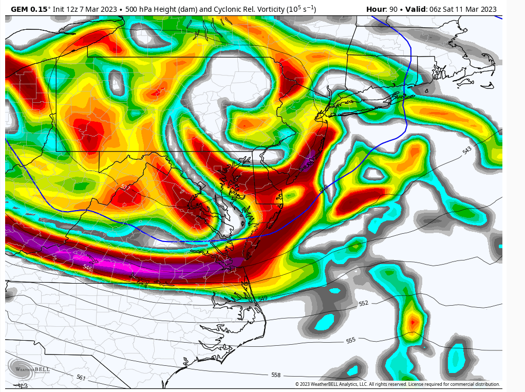
For Friday night/Sat morning Canadian 12Z. Yes I think Friday night is when we start precipitating. Mostly due to the western ridge moving the ULL faster.
Right here is critical IMO for interior snowfall NW of I-95. As the 500 mb approaches the coast how strong is it and how fast is it? My guess it's picking up speed due to ridge and also picking up strength. That will instigate mid-level forcing for areas to the north.
I think I-81 gets accumulating snow with this, but for those closer to I95 like EPA, NEPA, LHV not sure yet.
Definitely not in the camp of coastal storm affecting the area ATTM as I believe the ULL is going to be pushed too far SE for mid-level energy to affect many. The flip side is if it wasn't it'd go to our north and it'd be rain anyways.

heehaw453- Advanced Forecaster

- Posts : 3906
Reputation : 86
Join date : 2014-01-20
Location : Bedminster Township, PA Elevation 600' ASL
 Re: Long Range Thread 26.0
heehaw453 wrote:For Friday night/Sat morning Canadian 12Z. Yes I think Friday night is when we start precipitating. Mostly due to the western ridge moving the ULL faster.
Right here is critical IMO for interior snowfall NW of I-95. As the 500 mb approaches the coast how strong is it and how fast is it? My guess it's picking up speed due to ridge and also picking up strength. That will instigate mid-level forcing for areas to the north.
I think I-81 gets accumulating snow with this, but for those closer to I95 like EPA, NEPA, LHV not sure yet.
Definitely not in the camp of coastal storm affecting the area ATTM as I believe the ULL is going to be pushed too far SE for mid-level energy to affect many. The flip side is if it wasn't it'd go to our north and it'd be rain anyways.
I personally am not quite ready to look at the mid levels just yet as I thiunk there is still much to sort out at 500. While I dont put much stock in the CMC's individual model out put as it has been the worst model this season by far, I will often times use it for trends and see if it leans more towards the GFS or Euro.
For at least the last 4 model cycles it has trended to a soln that is more in line with the GFS at 500mb with regards to the interactions with the Polar jet stream. If this interaction does indeed occur my guess is a colder soln is coming, and more northerly SLP will cont, keeping the coastal plain definitely in the game as the "tug" will occur. from the N. If this interaction does not occur, like I highlighted this am on the Euro, or if it occurs too late, then I think it will be a warmer soln overall, esp coastal plain, and a more southerly trajectory to the slp.


_________________
"In weather and in life, there's no winning and losing; there's only winning and learning."
WINTER 2012/2013 TOTALS 43.65"WINTER 2017/2018 TOTALS 62.85" WINTER 2022/2023 TOTALS 4.9"
WINTER 2013/2014 TOTALS 64.85"WINTER 2018/2019 TOTALS 14.25" WINTER 2023/2024 TOTALS 13.1"
WINTER 2014/2015 TOTALS 71.20"WINTER 2019/2020 TOTALS 6.35"
WINTER 2015/2016 TOTALS 35.00"WINTER 2020/2021 TOTALS 37.75"
WINTER 2016/2017 TOTALS 42.25"WINTER 2021/2022 TOTALS 31.65"

sroc4- Admin

- Posts : 8331
Reputation : 301
Join date : 2013-01-07
Location : Wading River, LI
 Re: Long Range Thread 26.0
Thanks sroc and nice trend chart showing CMC evolution. I like to look at CMC when Euro/GFS are pretty far apart which they are. I see CMC being more inline with Euro and I see Euro having done the best with recognition of the s/w trajectory so far. GFS IMO has been following all along. I agree it's not set in stone, but the upper levels will drive the mid-levels and if CMC/Euro are right with the ULL, then this will be minor/moderate snowfall for I81 and possibly to the NW of I95. And 100% it will be warmer, but cold enough for snow in interior. Things can change at this range, so let's see if Euro goes more towards that better interaction with Atl trough.
heehaw453- Advanced Forecaster

- Posts : 3906
Reputation : 86
Join date : 2014-01-20
Location : Bedminster Township, PA Elevation 600' ASL
heehaw453- Advanced Forecaster

- Posts : 3906
Reputation : 86
Join date : 2014-01-20
Location : Bedminster Township, PA Elevation 600' ASL
SENJsnowman likes this post
 Re: Long Range Thread 26.0
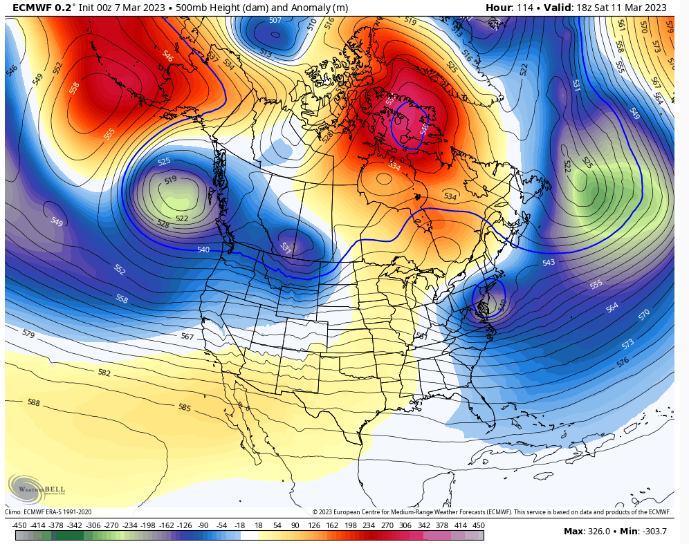
Euro def took steps to a colder soln and interaction with Atl trough. Here are 12z yest, 00z overnight and current. Liking the trends so far today. Obv its yet to be determined as to how far this all can go, but positive so far none the less. Our S/w comes on shore in the west late afternoon early eve tomorrow fwiw. Lets see if EPS follows suit.
Side note. Take note also on the euro AND CMC in the prev post the ridge is trending stronger centered between the Hudson Bay and Greenland.


Side note. Take note also on the euro AND CMC in the prev post the ridge is trending stronger centered between the Hudson Bay and Greenland.


_________________
"In weather and in life, there's no winning and losing; there's only winning and learning."
WINTER 2012/2013 TOTALS 43.65"WINTER 2017/2018 TOTALS 62.85" WINTER 2022/2023 TOTALS 4.9"
WINTER 2013/2014 TOTALS 64.85"WINTER 2018/2019 TOTALS 14.25" WINTER 2023/2024 TOTALS 13.1"
WINTER 2014/2015 TOTALS 71.20"WINTER 2019/2020 TOTALS 6.35"
WINTER 2015/2016 TOTALS 35.00"WINTER 2020/2021 TOTALS 37.75"
WINTER 2016/2017 TOTALS 42.25"WINTER 2021/2022 TOTALS 31.65"

sroc4- Admin

- Posts : 8331
Reputation : 301
Join date : 2013-01-07
Location : Wading River, LI
 Re: Long Range Thread 26.0
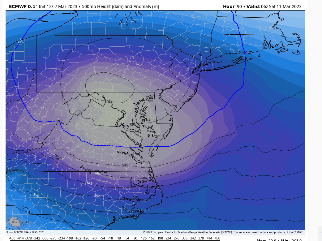
12Z Euro
This gets me interested to see ULL close off before it hits the coast and strengthen. That kick starts a stronger mid-level reaction while there is still time. And an ULL that closes off cannot be trusted as it can stall and disconnect from the flow. This obviously is difficult for models to nail down at D3+, so expect that to waffle. But I think that's the path here for any decent snowfall for the area close off early and maintain strength.
This gets me interested to see ULL close off before it hits the coast and strengthen. That kick starts a stronger mid-level reaction while there is still time. And an ULL that closes off cannot be trusted as it can stall and disconnect from the flow. This obviously is difficult for models to nail down at D3+, so expect that to waffle. But I think that's the path here for any decent snowfall for the area close off early and maintain strength.

heehaw453- Advanced Forecaster

- Posts : 3906
Reputation : 86
Join date : 2014-01-20
Location : Bedminster Township, PA Elevation 600' ASL
sroc4 likes this post
 Re: Long Range Thread 26.0
This is a great side by side. Thanks.sroc4 wrote:Euro def took steps to a colder soln and interaction with Atl trough. Here are 12z yest, 00z overnight and current. Liking the trends so far today. Obv its yet to be determined as to how far this all can go, but positive so far none the less. Our S/w comes on shore in the west late afternoon early eve tomorrow fwiw. Lets see if EPS follows suit.
Side note. Take note also on the euro AND CMC in the prev post the ridge is trending stronger centered between the Hudson Bay and Greenland.
heehaw453- Advanced Forecaster

- Posts : 3906
Reputation : 86
Join date : 2014-01-20
Location : Bedminster Township, PA Elevation 600' ASL
sroc4 likes this post
heehaw453- Advanced Forecaster

- Posts : 3906
Reputation : 86
Join date : 2014-01-20
Location : Bedminster Township, PA Elevation 600' ASL
sroc4 likes this post
 Re: Long Range Thread 26.0
So is nyc in the game for any storm coming up
Carvin- Posts : 44
Reputation : 2
Join date : 2019-01-09
 Re: Long Range Thread 26.0
I would think it would be possible for the nyc area to see snow with the systems be discussed but we will see and I of course would defer to some of the far more knowledgeable and experienced folks
phil155- Pro Enthusiast

- Posts : 475
Reputation : 4
Join date : 2019-12-16
heehaw453- Advanced Forecaster

- Posts : 3906
Reputation : 86
Join date : 2014-01-20
Location : Bedminster Township, PA Elevation 600' ASL
heehaw453- Advanced Forecaster

- Posts : 3906
Reputation : 86
Join date : 2014-01-20
Location : Bedminster Township, PA Elevation 600' ASL
heehaw453- Advanced Forecaster

- Posts : 3906
Reputation : 86
Join date : 2014-01-20
Location : Bedminster Township, PA Elevation 600' ASL
 Re: Long Range Thread 26.0
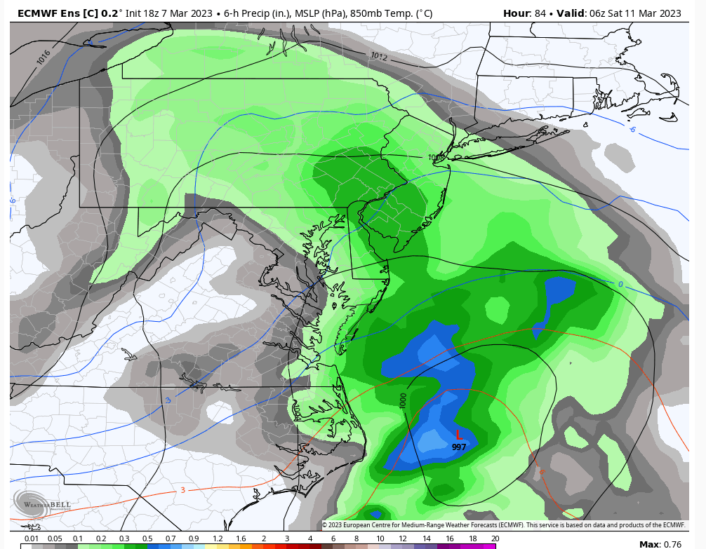
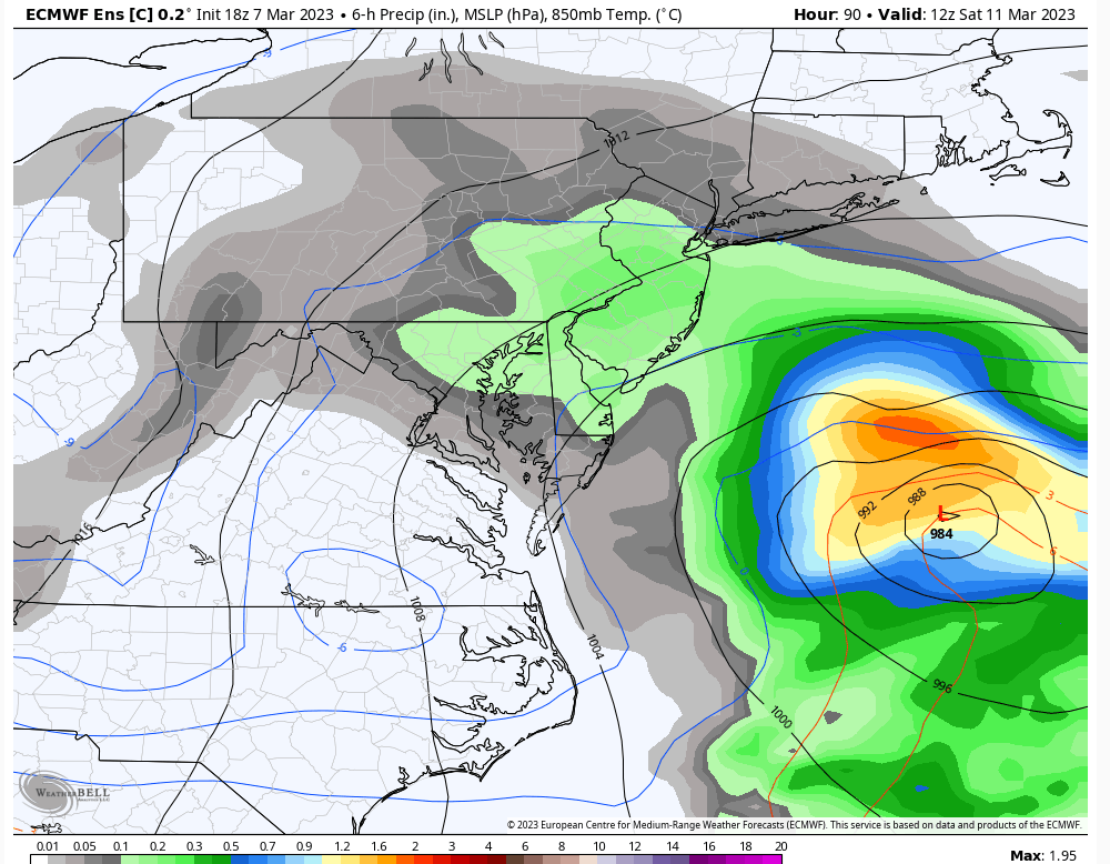
heehaw, correct me if I'm wrong...but isn't that exactly the image what a Jersey Shore coastie wants to see? I mean that's a 984 low, which is fairly strong, and the red freezing line is WAY offshore. Or no? Am I just looking at this through rose colored/bourbon altered glasses?
SENJsnowman- Senior Enthusiast

- Posts : 1186
Reputation : 61
Join date : 2017-01-06
Age : 51
Location : Bayville, NJ
weatherwatchermom likes this post
 Re: Long Range Thread 26.0
Hi. I don't like the lower layer boundary temp profile for accumulating snows on coastal plain. My area continues to be I81 to NEPA, EPA and possibly LHV. Higher elevations will do better than lower ones in those areas.SENJsnowman wrote:
heehaw, correct me if I'm wrong...but isn't that exactly the image what a Jersey Shore coastie wants to see? I mean that's a 984 low, which is fairly strong, and the red freezing line is WAY offshore. Or no? Am I just looking at this through rose colored/bourbon altered glasses?
heehaw453- Advanced Forecaster

- Posts : 3906
Reputation : 86
Join date : 2014-01-20
Location : Bedminster Township, PA Elevation 600' ASL
SENJsnowman likes this post
 Re: Long Range Thread 26.0
SENJsnowman wrote:
heehaw, correct me if I'm wrong...but isn't that exactly the image what a Jersey Shore coastie wants to see? I mean that's a 984 low, which is fairly strong, and the red freezing line is WAY offshore. Or no? Am I just looking at this through rose colored/bourbon altered glasses?
Low levels are going to torch with the strong east component to the wind. With the lack of any heavy precip, most southern areas even in a set up like that will likely not see accumulating snowfall. The set up this weekend is not conducive for snow in CNJ south.
A latitudinally transversing 500 hPa ULL, with strong WAA and southerly flow that leads to an overhead transfer (PA to off the JS for both the 850 hPA and 500 hPa lows) to an offshore, where all the favorable cyclogenic forcing is also offshore once temperatures cool via CAA from the wind shift, will not lead to any significant snows in the region. Once the coastal low is developed enough to form a mature precipitation shield, it is far to east to impact the region.
In fact, the overrunning from the initial ULL approach will likely drop more snow than this coastal storm unless significant changes occur on guidance.

Quietace- Meteorologist - Mod

- Posts : 3687
Reputation : 33
Join date : 2013-01-07
Age : 27
Location : Point Pleasant, NJ
sroc4, heehaw453 and SENJsnowman like this post
 Re: Long Range Thread 26.0
Very much agree that Saturday will be difficult to see accumulating snow from CNJ and points south. It looks like even parts of NNJ including NYC may struggle, but still a little time to iron out specifics. I think NW NJ and N&W of NYC are in line for a light snowfall event.
The Monday-Tuesday storm has a chance to be special, but we’re dealing with some hiccups in the pattern. For one, the Saturday storm tries to “blow up” offshore and tries to become the 50-50 Low for the Monday storm. We have to watch this. The EURO amplifies heights along the EC enough to allow a northern and southern s/w phase, while GFS shows flatter heights as a result of Saturdays storm which keeps the Monday storm to our S&E.
The other thing to watch is western ridge. Currently one is being modeled but if it’s too quick to slide east or be too flat we’ll have issues with phasing, or this turns out to be a northern stream driven event which will only bring impact to areas N&W of NYC
_________________
_______________________________________________________________________________________________________
CLICK HERE to view NJ Strong Snowstorm Classifications
sroc4, heehaw453, SENJsnowman and Meepers55 like this post
Page 3 of 6 •  1, 2, 3, 4, 5, 6
Permissions in this forum:
You cannot reply to topics in this forum|
|
|

 Home
Home
