
 Search
Long Range Thread 27.0
Page 2 of 40 •  1, 2, 3 ... 21 ... 40
 ![]()
Re: Long Range Thread 27.0
![]() by sroc4 Thu Oct 19, 2023 9:39 am
by sroc4 Thu Oct 19, 2023 9:39 am
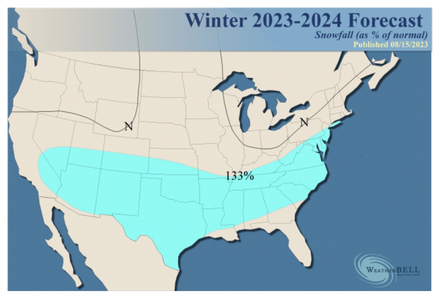
https://wxrisk.com/wp-content/uploads/_pda/2023/10/winter-2023-24.pdf
sroc4- Admin

- Posts : 8331
Join date : 2013-01-07
Re: Long Range Thread 27.0
![]() by amugs Thu Oct 19, 2023 6:05 pm
by amugs Thu Oct 19, 2023 6:05 pm
https://arcfieldweather.com/blog/2023/10/17/2023-2024-winter-outlook-by-arcfield-weather
amugs- Advanced Forecaster - Mod

- Posts : 15093
Join date : 2013-01-07
Re: Long Range Thread 27.0
![]() by amugs Fri Oct 20, 2023 12:00 pm
by amugs Fri Oct 20, 2023 12:00 pm
Phases 8 and 1 and why? That were the greatest equatorial convenctoin of t-storms is taking place and is forecasted too
Black circled areas are MJO convection phases that are 8,1 and 7 which allow for greater propensity of cold and snow in the East. Just one piece to the puzzle but a pretty important one.
Blue circled areas are the warm phases by the maritime continent of phases 4-6,. We see drier conditions which helps tamper the SE ridge that we had ALL last winter and could never break from. These areas last year is where all the tropical convection was happening thus an abnormally warm winter.
Nature has her way of balancing things out over time.
Forcasted:

_________________
Mugs
AKA:King: Snow Weenie
Self Proclaimed
WINTER 2014-15 : 55.12" +.02 for 6 coatings (avg. 35")
WINTER 2015-16 Total - 29.8" (Avg 35")
WINTER 2016-17 : 39.5" so far

amugs- Advanced Forecaster - Mod
- Posts : 15093
Reputation : 213
Join date : 2013-01-07
Age : 54
Location : Hillsdale,NJ
Re: Long Range Thread 27.0
![]() by amugs Fri Oct 20, 2023 12:08 pm
by amugs Fri Oct 20, 2023 12:08 pm
95-96 had a similar set up but Nov 7 or 8th I recall and NW NJ recieved a slushy coating on colder surfaces, that kick started the most incredible winter of my 53 years on this beautiful rock we call earth. Bring this 72 hours out and I'll jump all over it but better than a weekend as we've have.
_________________
Mugs
AKA:King: Snow Weenie
Self Proclaimed
WINTER 2014-15 : 55.12" +.02 for 6 coatings (avg. 35")
WINTER 2015-16 Total - 29.8" (Avg 35")
WINTER 2016-17 : 39.5" so far
amugs- Advanced Forecaster - Mod
- Posts : 15093
Reputation : 213
Join date : 2013-01-07
Age : 54
Location : Hillsdale,NJ
Re: Long Range Thread 27.0
![]() by amugs Fri Oct 20, 2023 12:10 pm
by amugs Fri Oct 20, 2023 12:10 pm
_________________
Mugs
AKA:King: Snow Weenie
Self Proclaimed
WINTER 2014-15 : 55.12" +.02 for 6 coatings (avg. 35")
WINTER 2015-16 Total - 29.8" (Avg 35")
WINTER 2016-17 : 39.5" so far
amugs- Advanced Forecaster - Mod
- Posts : 15093
Reputation : 213
Join date : 2013-01-07
Age : 54
Location : Hillsdale,NJ
Re: Long Range Thread 27.0
![]() by amugs Fri Oct 20, 2023 12:13 pm
by amugs Fri Oct 20, 2023 12:13 pm
_________________
Mugs
AKA:King: Snow Weenie
Self Proclaimed
WINTER 2014-15 : 55.12" +.02 for 6 coatings (avg. 35")
WINTER 2015-16 Total - 29.8" (Avg 35")
WINTER 2016-17 : 39.5" so far
amugs- Advanced Forecaster - Mod
- Posts : 15093
Reputation : 213
Join date : 2013-01-07
Age : 54
Location : Hillsdale,NJ
weatherwatchermom and phil155 like this post
Re: Long Range Thread 27.0
![]() by weatherwatchermom Fri Oct 20, 2023 2:30 pm
by weatherwatchermom Fri Oct 20, 2023 2:30 pm
I was a little surprised that they said we would be above normal temps..amugs wrote:Take what NOAA says with a grain of salt

weatherwatchermom- Senior Enthusiast

- Posts : 3738
Reputation : 77
Join date : 2014-11-25
Age : 60
Location : Hazlet Township, NJ
Re: Long Range Thread 27.0
![]() by dkodgis Fri Oct 20, 2023 5:40 pm
by dkodgis Fri Oct 20, 2023 5:40 pm

dkodgis- Senior Enthusiast
- Posts : 2501
Reputation : 98
Join date : 2013-12-29
Re: Long Range Thread 27.0
![]() by Frank_Wx Fri Oct 20, 2023 5:44 pm
by Frank_Wx Fri Oct 20, 2023 5:44 pm
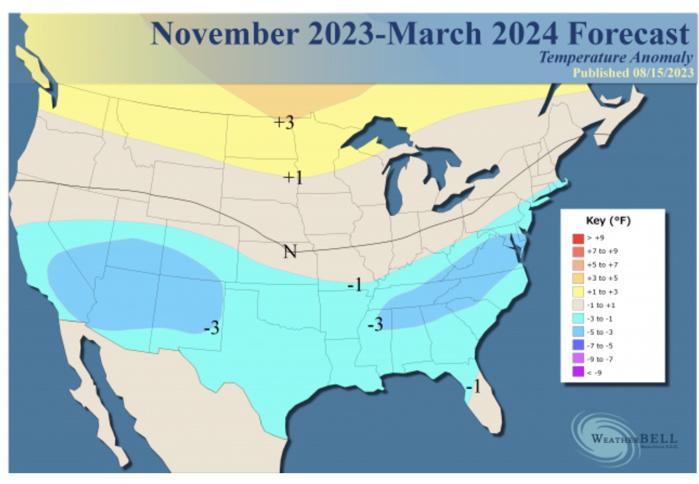
As Al pointed out - NOAA is forecasting a strong El Nino event. In their ENSO update, they cite a "75%-85%" likelihood of a strong El Nino forming and lasting through winter. Here is their temperature and precipitation outlook.


Sometimes people get caught up in the colors. For me personally, seeing wetter than normal conditions along the coast gives me hope that we are in for an active winter regardless of where the "snow" line sets up. The best snowfalls normally happen when the battle zone is draped over our area. Of course it sucks for those S&E of it, but I have a feeling that will be a common theme this year. Where it sets up is anyone's guess.

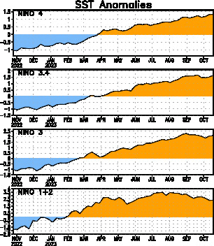
A look at how ENSO has progressed over the last few months. The trend is clear - El Nino is coming. It is already here honestly. The ONI was already 1.1 coming out of August. It warmed to 1.3 after September, and from everything I'm seeing, the ONI should be at or above 1.5 once October is recorded. For context, a 1.4 to 1.8 is considered 'moderate.' Above a 1.8 ONI and you're looking at a pretty strong El Nino. Our last El Nino winter was 2019 when the ONI averaged +0.7. Granted NYC only got around 20" of snow that winter, but I believe interior locations did very well. However, it would not have taken much for NYC to surpass that amount. It really depends on the storm tracks, which is dictated by where blocking sets up.
We have to keep an eye on the MJO and Stratosphere, of course. Those are the other 2 big players in the overall winter pattern. Last year the MJO worked AGAINST us. It was frequently in the 'warmer' phases and caused the SE Ridge to dominate our weather. This year, with El Nino present, there's a chance we see the convection try to stay more in the western Pacific. This will pump the ridge over the western parts of the country (-EPO/+PNA) and stream colder air into the eastern CONUS.
I'm excited to finally get back into tracking! Maybe a few nights of live chats and what not to turn the clock back a bit. Its been awhile for sure.
_________________
_______________________________________________________________________________________________________
CLICK HERE to view NJ Strong Snowstorm Classifications

Frank_Wx- Godzilla Seeker
- Posts : 21305
Reputation : 328
Join date : 2013-01-05
Age : 31
Location : Jersey City, NJ -

docstox12, kalleg, mmanisca, Grselig, nancy-j-s, weatherwatchermom, billg315 and like this post
Re: Long Range Thread 27.0
![]() by sroc4 Mon Oct 23, 2023 7:48 am
by sroc4 Mon Oct 23, 2023 7:48 am
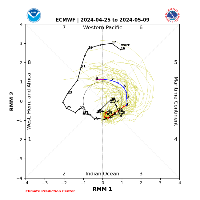
amugs wrote:This pattern shows snow potential for interior and lays down the snow in CANADA which helps our cold air source.

Dont shoot the messenger, but looking at a few things it appears this look on this image is going to be pretty transient. While it does appear after a warm up later this week into the weekend, the start to November looks cool to cold; however, behind this Im not so sure.
In the modeling, behind this cool shot you get negatives showing back up through the rest of the run along the west coast. This look leads me to believe you get the CONUS's main air mass of Pacific origin. Without any real snow pack in Canada, esp the eastern half, there is no real Ooomf if you will to any cold shots yet. And while the look on this image should lay down some snow to our north in Canada, with it being so transient I don't think it has a ton of staying power yet.

Now of course we are talking about a pattern that is over 10 days out so there is room for evolution and change in the modeling as there always is. That said to me there is some things that make me think its real and will result in a warm November overall. That is the MJO.
MJO seems to be stuck in a loop in and around phase 8-1. Now one might think wait. I thought we want phase 8 and or 1 for cold and snow. In winter the answer to this would be hell yeah. But during different times of year the same phase for winter can result in different pattern during other times of year. Here is the current MJO forecast; then the temp composites those phases match with for Sept/Oct/Nov(SON), and Oct/Nov/Dec(NOD):


While you can see phase 8 for OND looks like a cold phase, this is likely the case as we get deeper into the fall. The fact that SON is clearly warm in both phases tells me the fall is a transition period for phase 8 MJO. Since we are in the early parts of this transition the MJO forecast does lend support to what is showing up on the LR modeling I highlighted above. On top of that the OLR (outgoing longwave radiation) past 30 day trends over the past month do line up with the going MJO forecasts. With the Trop Pac SSTA configuration the way it is I see no real reason to think this trend wont cont. for the time being.


Now final thoughts are while this MAY lead to a warm November, IF the same OLR/MJO signal trends continue deeper into the cold season this will lead to cold and snow chances galore.
_________________
"In weather and in life, there's no winning and losing; there's only winning and learning."
WINTER 2012/2013 TOTALS 43.65"WINTER 2017/2018 TOTALS 62.85" WINTER 2022/2023 TOTALS 4.9"
WINTER 2013/2014 TOTALS 64.85"WINTER 2018/2019 TOTALS 14.25" WINTER 2023/2024 TOTALS 13.1"
WINTER 2014/2015 TOTALS 71.20"WINTER 2019/2020 TOTALS 6.35"
WINTER 2015/2016 TOTALS 35.00"WINTER 2020/2021 TOTALS 37.75"
WINTER 2016/2017 TOTALS 42.25"WINTER 2021/2022 TOTALS 31.65"

sroc4- Admin
- Posts : 8331
Reputation : 301
Join date : 2013-01-07
Location : Wading River, LI
Grselig and weatherwatchermom like this post
Re: Long Range Thread 27.0
![]() by frank 638 Thu Oct 26, 2023 2:00 pm
by frank 638 Thu Oct 26, 2023 2:00 pm

frank 638- Senior Enthusiast
- Posts : 2824
Reputation : 37
Join date : 2016-01-01
Age : 40
Location : bronx ny
weatherwatchermom likes this post
Re: Long Range Thread 27.0
![]() by sroc4 Thu Oct 26, 2023 3:28 pm
by sroc4 Thu Oct 26, 2023 3:28 pm
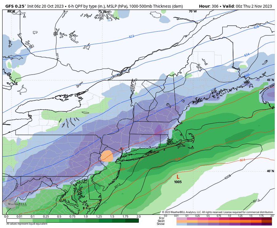
frank 638 wrote:Has anyone checked out the long range from tropical tidbits on November 9. They have a rain to snow event. It looks like a strong hurricane or nor Easter I’m sorry I am not that good reading the Weather models that’s why I leave it to the experts. What are you guys think of this?
Only thing for certain I will say about that Frank is that that soln will change. We are talking about a tropical system landfalling in Fla; then trekking NNE and transitioning to extratropical as it makes it into the NE. There is soooo much that has to go right for that to come to fruition. That said the pattern is such that you never know.
_________________
"In weather and in life, there's no winning and losing; there's only winning and learning."
WINTER 2012/2013 TOTALS 43.65"WINTER 2017/2018 TOTALS 62.85" WINTER 2022/2023 TOTALS 4.9"
WINTER 2013/2014 TOTALS 64.85"WINTER 2018/2019 TOTALS 14.25" WINTER 2023/2024 TOTALS 13.1"
WINTER 2014/2015 TOTALS 71.20"WINTER 2019/2020 TOTALS 6.35"
WINTER 2015/2016 TOTALS 35.00"WINTER 2020/2021 TOTALS 37.75"
WINTER 2016/2017 TOTALS 42.25"WINTER 2021/2022 TOTALS 31.65"
sroc4- Admin
- Posts : 8331
Reputation : 301
Join date : 2013-01-07
Location : Wading River, LI
weatherwatchermom likes this post
Re: Long Range Thread 27.0
![]() by Frank_Wx Thu Oct 26, 2023 10:37 pm
by Frank_Wx Thu Oct 26, 2023 10:37 pm
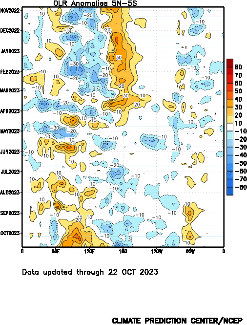
OLR anomalies indicate convection across the tropical Pacific is forming over Nino region 3.4.
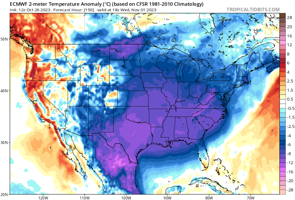
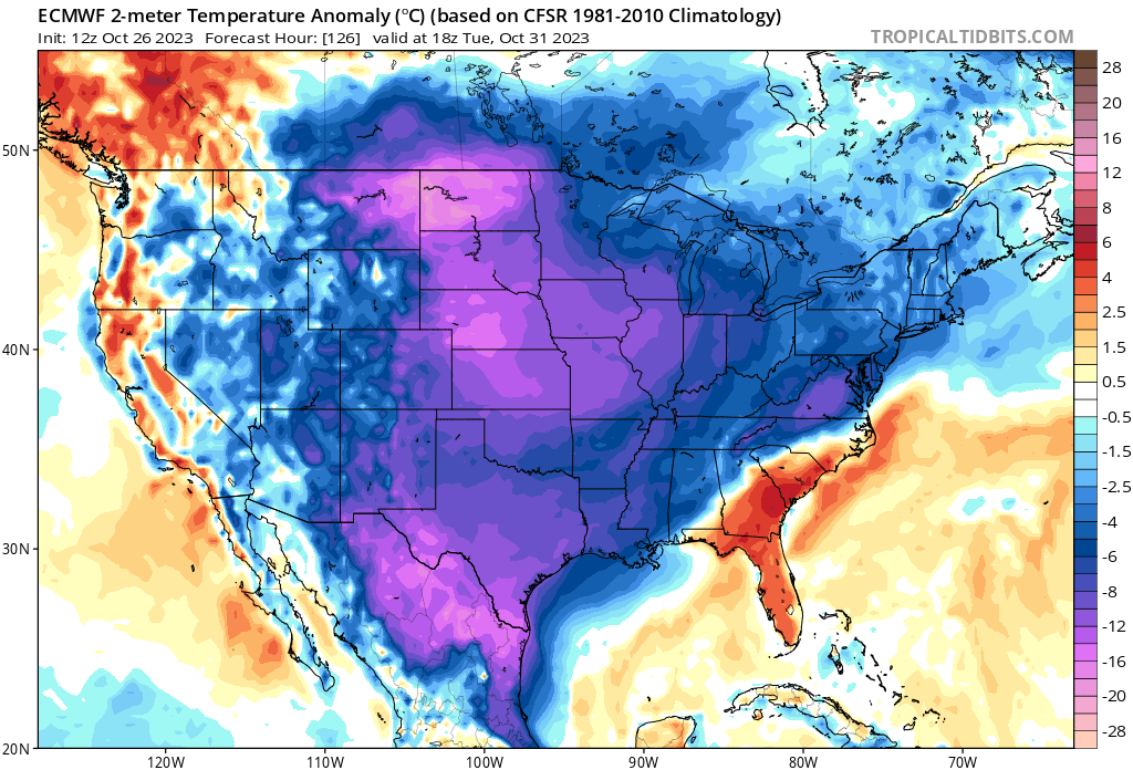
We’re already seeing the affects in the atmosphere. The EPO is in an anomalous negative phase, which will lead to our first real blast of cold temperatures next week. Here are temp anomalies from normal on Halloween and Thursday. This also lasts through next weekend.
Some models are trying to get a little frisky around November 1st. I’ll keep an eye on that. For now I’m giving is a very small chance of it becoming an issue in terms of snowfall. Regardless, the long range prospects are exciting. I would be very shocked if we are not tracking several events this season. Bring it on!
_________________
_______________________________________________________________________________________________________
CLICK HERE to view NJ Strong Snowstorm Classifications
Frank_Wx- Godzilla Seeker
- Posts : 21305
Reputation : 328
Join date : 2013-01-05
Age : 31
Location : Jersey City, NJ -
sroc4, kalleg and MattyICE like this post
Re: Long Range Thread 27.0
![]() by amugs Fri Oct 27, 2023 1:10 pm
by amugs Fri Oct 27, 2023 1:10 pm
Phase 8 and rotates thorugh 1

_________________
Mugs
AKA:King: Snow Weenie
Self Proclaimed
WINTER 2014-15 : 55.12" +.02 for 6 coatings (avg. 35")
WINTER 2015-16 Total - 29.8" (Avg 35")
WINTER 2016-17 : 39.5" so far
amugs- Advanced Forecaster - Mod
- Posts : 15093
Reputation : 213
Join date : 2013-01-07
Age : 54
Location : Hillsdale,NJ
Re: Long Range Thread 27.0
![]() by Frank_Wx Fri Oct 27, 2023 2:35 pm
by Frank_Wx Fri Oct 27, 2023 2:35 pm
It has the entire CONUS with above normal temps NOV-JAN. It starts to resemble an El Nino-ish pattern starting in February through March.
I find it hard to believe the atmosphere does not respond to El Nino until February.
_________________
_______________________________________________________________________________________________________
CLICK HERE to view NJ Strong Snowstorm Classifications
Frank_Wx- Godzilla Seeker
- Posts : 21305
Reputation : 328
Join date : 2013-01-05
Age : 31
Location : Jersey City, NJ -
nancy-j-s likes this post
Re: Long Range Thread 27.0
![]() by amugs Sun Oct 29, 2023 3:39 pm
by amugs Sun Oct 29, 2023 3:39 pm
_________________
Mugs
AKA:King: Snow Weenie
Self Proclaimed
WINTER 2014-15 : 55.12" +.02 for 6 coatings (avg. 35")
WINTER 2015-16 Total - 29.8" (Avg 35")
WINTER 2016-17 : 39.5" so far
amugs- Advanced Forecaster - Mod
- Posts : 15093
Reputation : 213
Join date : 2013-01-07
Age : 54
Location : Hillsdale,NJ
jmanley32 likes this post
Re: Long Range Thread 27.0
![]() by jmanley32 Mon Oct 30, 2023 11:53 pm
by jmanley32 Mon Oct 30, 2023 11:53 pm
Edit, looking back on this thread looks like some bigger storm potentials might be there from now till the 15th but that amount I still find hard to believe, and yes I know they are just surface snow maps and don't mean anything especially this far out.

jmanley32- Senior Enthusiast
- Posts : 20516
Reputation : 108
Join date : 2013-12-12
Age : 42
Location : Yonkers, NY
Re: Long Range Thread 27.0
![]() by amugs Fri Nov 03, 2023 2:42 pm
by amugs Fri Nov 03, 2023 2:42 pm

1 = Phases 8 and 1 of MJO = Cold and stormy East Coast
2 = Phases 4-6 of MJO which will be a NO MJO with this SST
3 = Warmest Water near the dateling and migarte West - Basin Wide Modoki EL Nino = Colder Regime and increases snow posibility with a STJ = Sub Tropical Jet
4 = PDO going Positive - helps increase a N EPO which allows cross polar/siberian flow of colder air
5 - Cooler North Atlantic waters with warmer waters to its east prodcue a N NAO
Just a few pieces to the puzzle I see.
_________________
Mugs
AKA:King: Snow Weenie
Self Proclaimed
WINTER 2014-15 : 55.12" +.02 for 6 coatings (avg. 35")
WINTER 2015-16 Total - 29.8" (Avg 35")
WINTER 2016-17 : 39.5" so far
amugs- Advanced Forecaster - Mod
- Posts : 15093
Reputation : 213
Join date : 2013-01-07
Age : 54
Location : Hillsdale,NJ
sroc4 and docstox12 like this post
Re: Long Range Thread 27.0
![]() by nutleyblizzard Sun Nov 05, 2023 10:38 am
by nutleyblizzard Sun Nov 05, 2023 10:38 am


nutleyblizzard- Senior Enthusiast
- Posts : 1952
Reputation : 41
Join date : 2014-01-30
Age : 58
Location : Nutley, new jersey
Re: Long Range Thread 27.0
![]() by tomsriversnowstorm Sun Nov 05, 2023 11:43 am
by tomsriversnowstorm Sun Nov 05, 2023 11:43 am
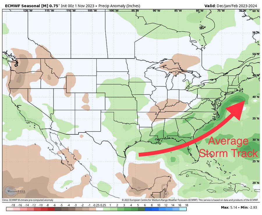
nutleyblizzard wrote:Euro Seasonal looks great for Jan/Feb.
Can you explain why this is a great look. The maps look like a different language to me. Sorry I am new and trying to learn.
tomsriversnowstorm- Posts : 90
Reputation : 0
Join date : 2021-02-06
Re: Long Range Thread 27.0
![]() by amugs Sun Nov 05, 2023 2:22 pm
by amugs Sun Nov 05, 2023 2:22 pm
tomsriversnowstorm wrote:nutleyblizzard wrote:Euro Seasonal looks great for Jan/Feb.
Can you explain why this is a great look. The maps look like a different language to me. Sorry I am new and trying to learn.
They look great because you have high heights over the cold source regions of the the Artic, North Pole and North Atlantic. Those are the yellowish colors. You also have higher heights over the Canadian and USA West Coast leading to a positive PNA. The blue color is trough that is situated to our SE which means storminess. Where the trough sets up is usually the paths of the storms. I hope this helps. Being North of the trough allows for cold air to be pulled down for snow and ice events, also possibly suppression but those details are not nearly solved until days before the storm. Overall it is a look that you want at this juncture for cold and snow.
_________________
Mugs
AKA:King: Snow Weenie
Self Proclaimed
WINTER 2014-15 : 55.12" +.02 for 6 coatings (avg. 35")
WINTER 2015-16 Total - 29.8" (Avg 35")
WINTER 2016-17 : 39.5" so far
amugs- Advanced Forecaster - Mod
- Posts : 15093
Reputation : 213
Join date : 2013-01-07
Age : 54
Location : Hillsdale,NJ
Re: Long Range Thread 27.0
![]() by amugs Sun Nov 05, 2023 2:28 pm
by amugs Sun Nov 05, 2023 2:28 pm
MJO Phases 8 and 1 not 3-6 which are warm. 8 and 1 are cold and stormy (snowy) KU potential this year calling it.

_________________
Mugs
AKA:King: Snow Weenie
Self Proclaimed
WINTER 2014-15 : 55.12" +.02 for 6 coatings (avg. 35")
WINTER 2015-16 Total - 29.8" (Avg 35")
WINTER 2016-17 : 39.5" so far
amugs- Advanced Forecaster - Mod
- Posts : 15093
Reputation : 213
Join date : 2013-01-07
Age : 54
Location : Hillsdale,NJ
Re: Long Range Thread 27.0
![]() by amugs Sun Nov 05, 2023 2:32 pm
by amugs Sun Nov 05, 2023 2:32 pm
_________________
Mugs
AKA:King: Snow Weenie
Self Proclaimed
WINTER 2014-15 : 55.12" +.02 for 6 coatings (avg. 35")
WINTER 2015-16 Total - 29.8" (Avg 35")
WINTER 2016-17 : 39.5" so far
amugs- Advanced Forecaster - Mod
- Posts : 15093
Reputation : 213
Join date : 2013-01-07
Age : 54
Location : Hillsdale,NJ
weatherwatchermom likes this post
Re: Long Range Thread 27.0
![]() by tomsriversnowstorm Mon Nov 06, 2023 5:38 pm
by tomsriversnowstorm Mon Nov 06, 2023 5:38 pm
amugs wrote:tomsriversnowstorm wrote:nutleyblizzard wrote:Euro Seasonal looks great for Jan/Feb.
Can you explain why this is a great look. The maps look like a different language to me. Sorry I am new and trying to learn.
They look great because you have high heights over the cold source regions of the the Artic, North Pole and North Atlantic. Those are the yellowish colors. You also have higher heights over the Canadian and USA West Coast leading to a positive PNA. The blue color is trough that is situated to our SE which means storminess. Where the trough sets up is usually the paths of the storms. I hope this helps. Being North of the trough allows for cold air to be pulled down for snow and ice events, also possibly suppression but those details are not nearly solved until days before the storm. Overall it is a look that you want at this juncture for cold and snow.
Thank you so much
tomsriversnowstorm- Posts : 90
Reputation : 0
Join date : 2021-02-06
Re: Long Range Thread 27.0
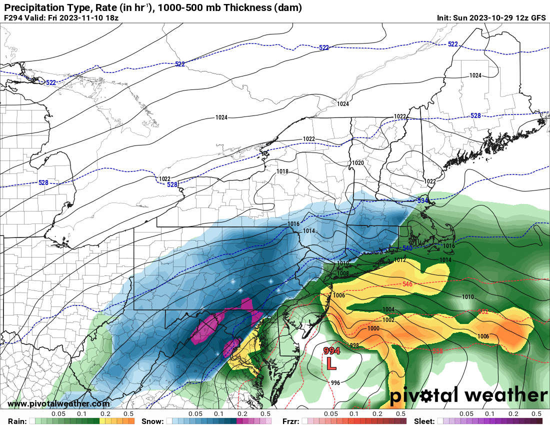
![]() by SENJsnowman Wed Nov 08, 2023 8:19 pm
by SENJsnowman Wed Nov 08, 2023 8:19 pm
amugs wrote:This storm track = bigly potential!!!
I love this time of year for a few reasons. One of them is the Spring Training-like optimism that infuses the winter weather discussions. Hopefully it works out for the better, snow-wise. But either way, I’m gonna root root root for the home team! And thanks to Mugs, SRoc and others for posting the exhibits and the analyses!
SENJsnowman- Senior Enthusiast
- Posts : 1186
Reputation : 61
Join date : 2017-01-06
Age : 51
Location : Bayville, NJ
JT33 likes this post
Re: Long Range Thread 27.0
![]() by Dunnzoo Thu Nov 09, 2023 10:39 am
by Dunnzoo Thu Nov 09, 2023 10:39 am

_________________
Janet
Snowfall winter of 2023-2024 17.5"
Snowfall winter of 2022-2023 6.0"
Snowfall winter of 2021-2022 17.6" 1" sleet 2/25/22
Snowfall winter of 2020-2021 51.1"
Snowfall winter of 2019-2020 8.5"
Snowfall winter of 2018-2019 25.1"
Snowfall winter of 2017-2018 51.9"
Snowfall winter of 2016-2017 45.6"
Snowfall winter of 2015-2016 29.5"
Snowfall winter of 2014-2015 50.55"
Snowfall winter of 2013-2014 66.5"

Dunnzoo- Senior Enthusiast - Mod
- Posts : 4891
Reputation : 68
Join date : 2013-01-11
Age : 62
Location : Westwood, NJ
weatherwatchermom likes this post
Re: Long Range Thread 27.0
![]() by weatherwatchermom Thu Nov 09, 2023 2:19 pm
by weatherwatchermom Thu Nov 09, 2023 2:19 pm
Dunnzoo wrote:wowzer, good thing I don't travel for Thanksgiving!
and this is why I booked son on the train to come home instead of us going to get him and bring him back(thank goodness he is coming home on Monday).. Lol. I felt like a terrible mom..but when we tried it out and brought him home for Columbus Day 3 day weekend it worked out great! He slept the 4 hours or played on his phone! and the station is only about 20 min from home... we drove up for parents weekend last Thurs and it took us 6 hours going up...urgh..so I have booked Christmas and Presidents weekend and spring break..
weatherwatchermom- Senior Enthusiast
- Posts : 3738
Reputation : 77
Join date : 2014-11-25
Age : 60
Location : Hazlet Township, NJ
Page 2 of 40 • 1, 2, 3 ... 21 ... 40 ![]()
|
|
|