
 Search
November 2023 Observations and Discussion
Page 5 of 7 •  1, 2, 3, 4, 5, 6, 7
 ![]()
Re: November 2023 Observations and Discussion
![]() by heehaw453 Wed Nov 22, 2023 1:23 pm
by heehaw453 Wed Nov 22, 2023 1:23 pm
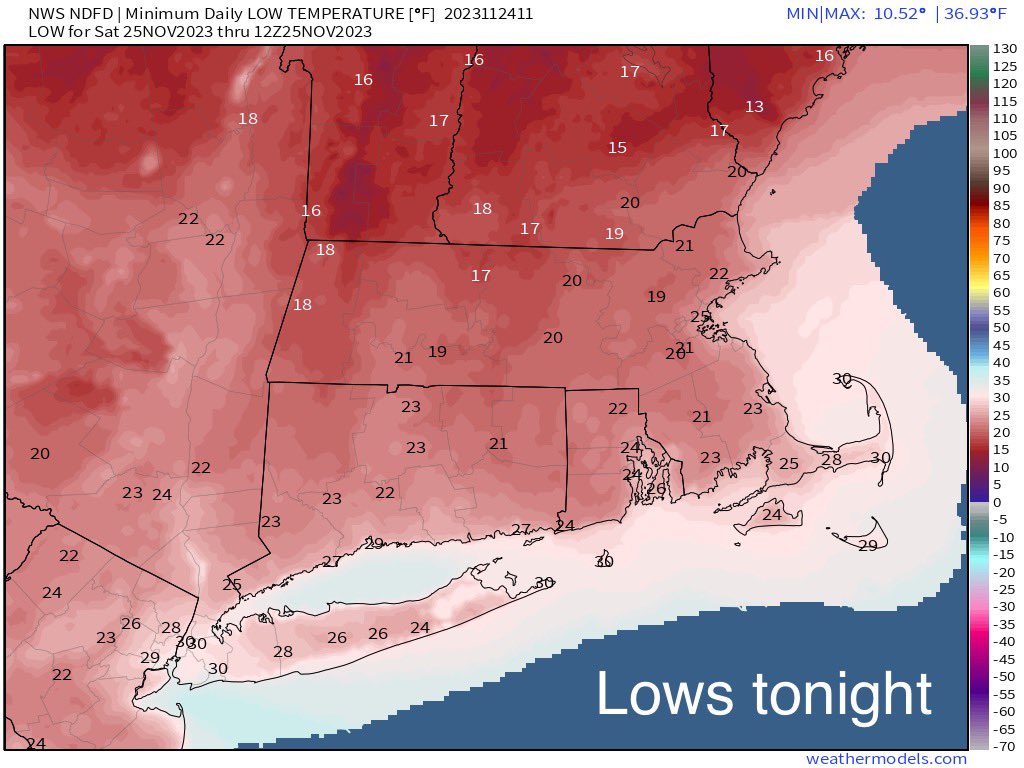
Central Park still yet to hit freezing, but it's likely it will be > 1 below normal for November. That will change on Friday night/Saturday morning as temps dip below freezing in the city.
Climo says coastal plain doesn't get its first measurable snowfall until mid December. IMBY I usually get measurable snowfall in November. We wait and see...
heehaw453- Advanced Forecaster

- Posts : 3906
Join date : 2014-01-20
docstox12 and dkodgis like this post
Re: November 2023 Observations and Discussion
![]() by frank 638 Thu Nov 23, 2023 8:54 am
by frank 638 Thu Nov 23, 2023 8:54 am
frank 638- Senior Enthusiast

- Posts : 2825
Join date : 2016-01-01
docstox12 likes this post


dkodgis- Senior Enthusiast
- Posts : 2505
Reputation : 98
Join date : 2013-12-29
docstox12 likes this post
Re: November 2023 Observations and Discussion
![]() by rb924119 Thu Nov 23, 2023 12:01 pm
by rb924119 Thu Nov 23, 2023 12:01 pm
rb924119- Meteorologist

- Posts : 6890
Reputation : 194
Join date : 2013-02-06
Age : 32
Location : Greentown, Pa
docstox12 and MattyICE like this post
Re: November 2023 Observations and Discussion
![]() by heehaw453 Fri Nov 24, 2023 9:29 am
by heehaw453 Fri Nov 24, 2023 9:29 am
The 500mb does suggest the storm should amp up and move slowly once doing so, but my thought is it does so a bit too far north for most folks around here. I just think there's not much cold air to work with at the onset and this will deepen as it gets past our latitude advecting the cold air behind it. Maybe elevated areas get something? But I think for most folks a cold rain incoming...rb924119 wrote:The threat for the 27th is alive and well folks. Don’t be surprised if the models start picking up on the white, as opposed to wet threat, especially for anybody north and west if I-287, in the coming days. I fully expect a colder/more consolidated trend with this one as we get closer. Whether or not it will be enough to get everybody in the game, I’m not sure. But I think some of us will definitely see an accumulating snow out of it.


heehaw453- Advanced Forecaster
- Posts : 3906
Reputation : 86
Join date : 2014-01-20
Location : Bedminster Township, PA Elevation 600' ASL
Re: November 2023 Observations and Discussion
![]() by sroc4 Fri Nov 24, 2023 10:01 am
by sroc4 Fri Nov 24, 2023 10:01 am
heehaw453 wrote:The 500mb does suggest the storm should amp up and move slowly once doing so, but my thought is it does so a bit too far north for most folks around here. I just think there's not much cold air to work with at the onset and this will deepen as it gets past our latitude advecting the cold air behind it. Maybe elevated areas get something? But I think for most folks a cold rain incoming...rb924119 wrote:The threat for the 27th is alive and well folks. Don’t be surprised if the models start picking up on the white, as opposed to wet threat, especially for anybody north and west if I-287, in the coming days. I fully expect a colder/more consolidated trend with this one as we get closer. Whether or not it will be enough to get everybody in the game, I’m not sure. But I think some of us will definitely see an accumulating snow out of it.
Beat me to it Haw. Just not seeing enough at 500 to warrant overt optimism for much of our coverage area with this one. There is too much disorganized lead vorticity for an initial wave of cold novermver rain and like mentioned the northern energy drops in too late. Northern NE may see a doozy and I guess perhaps there is still a little time for some of the higher elevations to get in on some flakes but overall it appears a cold Novermer rain is on the way.
_________________
"In weather and in life, there's no winning and losing; there's only winning and learning."
WINTER 2012/2013 TOTALS 43.65"WINTER 2017/2018 TOTALS 62.85" WINTER 2022/2023 TOTALS 4.9"
WINTER 2013/2014 TOTALS 64.85"WINTER 2018/2019 TOTALS 14.25" WINTER 2023/2024 TOTALS 13.1"
WINTER 2014/2015 TOTALS 71.20"WINTER 2019/2020 TOTALS 6.35"
WINTER 2015/2016 TOTALS 35.00"WINTER 2020/2021 TOTALS 37.75"
WINTER 2016/2017 TOTALS 42.25"WINTER 2021/2022 TOTALS 31.65"

sroc4- Admin

- Posts : 8331
Reputation : 301
Join date : 2013-01-07
Location : Wading River, LI
heehaw453 likes this post
Re: November 2023 Observations and Discussion
![]() by amugs Fri Nov 24, 2023 10:28 am
by amugs Fri Nov 24, 2023 10:28 am
_________________
Mugs
AKA:King: Snow Weenie
Self Proclaimed
WINTER 2014-15 : 55.12" +.02 for 6 coatings (avg. 35")
WINTER 2015-16 Total - 29.8" (Avg 35")
WINTER 2016-17 : 39.5" so far

amugs- Advanced Forecaster - Mod

- Posts : 15093
Reputation : 213
Join date : 2013-01-07
Age : 54
Location : Hillsdale,NJ
Re: November 2023 Observations and Discussion
![]() by Dunnzoo Fri Nov 24, 2023 2:55 pm
by Dunnzoo Fri Nov 24, 2023 2:55 pm
_________________
Janet
Snowfall winter of 2023-2024 17.5"
Snowfall winter of 2022-2023 6.0"
Snowfall winter of 2021-2022 17.6" 1" sleet 2/25/22
Snowfall winter of 2020-2021 51.1"
Snowfall winter of 2019-2020 8.5"
Snowfall winter of 2018-2019 25.1"
Snowfall winter of 2017-2018 51.9"
Snowfall winter of 2016-2017 45.6"
Snowfall winter of 2015-2016 29.5"
Snowfall winter of 2014-2015 50.55"
Snowfall winter of 2013-2014 66.5"

Dunnzoo- Senior Enthusiast - Mod
- Posts : 4892
Reputation : 68
Join date : 2013-01-11
Age : 62
Location : Westwood, NJ
docstox12 and brownie like this post
Re: November 2023 Observations and Discussion
![]() by weatherwatchermom Fri Nov 24, 2023 4:59 pm
by weatherwatchermom Fri Nov 24, 2023 4:59 pm
Last edited by weatherwatchermom on Fri Nov 24, 2023 9:00 pm; edited 1 time in total

weatherwatchermom- Senior Enthusiast
- Posts : 3750
Reputation : 77
Join date : 2014-11-25
Age : 60
Location : Hazlet Township, NJ
docstox12 likes this post
Re: November 2023 Observations and Discussion
![]() by frank 638 Fri Nov 24, 2023 5:03 pm
by frank 638 Fri Nov 24, 2023 5:03 pm
yes getting chilly 🥶 today. I did my Christmas shopping and I just finished putting up my Christmas lightsweatherwatchermom wrote:46* mowed lawn last time which in turn took care of the last leave...but ooh got chilly at the end there sunset was beautiful.
frank 638- Senior Enthusiast
- Posts : 2825
Reputation : 37
Join date : 2016-01-01
Age : 40
Location : bronx ny
docstox12, weatherwatchermom and phil155 like this post
Re: November 2023 Observations and Discussion
![]() by weatherwatchermom Fri Nov 24, 2023 9:04 pm
by weatherwatchermom Fri Nov 24, 2023 9:04 pm
frank 638 wrote:yes getting chilly 🥶 today. I did my Christmas shopping and I just finished putting up my Christmas lightsweatherwatchermom wrote:46* mowed lawn last time which in turn took care of the last leave...but ooh got chilly at the end there sunset was beautiful.
oh I got the shopping done as well..lol online and a little local after going out to dinner tonight..full day...tom I will start decorating.
Currently 37* winds at 20+ and the real feel is 19* I keep looking at Tues..husband going to freeze his hiney off with the boat winterization..I told him to pull it last weekend..
weatherwatchermom- Senior Enthusiast
- Posts : 3750
Reputation : 77
Join date : 2014-11-25
Age : 60
Location : Hazlet Township, NJ
Re: November 2023 Observations and Discussion
![]() by rb924119 Sat Nov 25, 2023 4:22 am
by rb924119 Sat Nov 25, 2023 4:22 am
sroc4 wrote:heehaw453 wrote:The 500mb does suggest the storm should amp up and move slowly once doing so, but my thought is it does so a bit too far north for most folks around here. I just think there's not much cold air to work with at the onset and this will deepen as it gets past our latitude advecting the cold air behind it. Maybe elevated areas get something? But I think for most folks a cold rain incoming...rb924119 wrote:The threat for the 27th is alive and well folks. Don’t be surprised if the models start picking up on the white, as opposed to wet threat, especially for anybody north and west if I-287, in the coming days. I fully expect a colder/more consolidated trend with this one as we get closer. Whether or not it will be enough to get everybody in the game, I’m not sure. But I think some of us will definitely see an accumulating snow out of it.
Beat me to it Haw. Just not seeing enough at 500 to warrant overt optimism for much of our coverage area with this one. There is too much disorganized lead vorticity for an initial wave of cold novermver rain and like mentioned the northern energy drops in too late. Northern NE may see a doozy and I guess perhaps there is still a little time for some of the higher elevations to get in on some flakes but overall it appears a cold Novermer rain is on the way.
Don’t get me wrong, fellas, I’m not saying everybody is gonna get snow, but I think those of us north and west of 287 (maybe I-80) have a legitimate shot at seeing some accumulation out of this. I wanted to make a video to explain, but I don’t think that I’ll have the time, so I’ll try to succinctly explain lol
Firstly, the overall pattern in the Northern Hemisphere strongly supports this trending colder, as we have the following factors favoring it:
-pseudo -NAO and 50/50 couplet
-70/70 ridge
-negative EPO
-positive PNA
We also have favorable tropics:
-negative SOI
-MJO phase
The ENSO state is neutral, in my opinion, as regions 1.2 and 3.4 are essential equally warm (anomaly-wise), however, we do have the anomalous warmth in the Gulf and Atlantic. The AO is essentially neutral, again, my opinion, and the WPO is positive. So, the warmth in the Gulf and Atlantic, and the positive WPO are not enough to resist the push from the trough coming into the eastern CONUS, in my opinion, which is why I like a colder trend here. This would thereby also support a faster and stronger northern stream system and earlier interaction with the lead wave, i.e. earlier injection of fresh cold air, into the lead system.
Additionally, I do not agree that the secondary low will be as late to bloom as guidance is suggesting when I look at the details. If you look at the following starting on Sunday, you’ll note the overlap in support for not only development of the secondary near the Delmarva, but also what should be an enhanced precip shield ahead of the front:
-lower level warm advection
-vorticity advection from both the relatively weaker lead wave plus the increasing advection from the northern stream energy AND general forcing for ascent downstream of the main trough axis
-decent jet support from the left exit region
Where is there support for the primary to remain the primary so long? From what I can tell, it’s occluded, as it’s already well removed from the jet. Based on this analysis, warm air transport ahead of the front should be less efficient, as the developing circulation from the secondary will work to retard it, drawing in cooler air from New England and the high pressure that should be able to exert a bit more influence than modeled thanks to the pseudo-NAO and 50/50 couplet. Temperatures near and above 850mb should remain sub-freezing, so that’s not the concern. As for the lower levels, 925-850mb, which is where the only warmth is for the areas I mentioned, if you’re drawing in cooler air from the northeast at the lower levels thanks to the sooner developing secondary low, then efficiently lifting that air thanks to the dynamics in play, it won’t take much to cool the column JUST ENOUGH to support snow. This time of year, you can snow in marginal air masses, and I think we will in the areas north and west of I-287/I-80. I haven’t really considered amounts, as my battle here is more with the white versus wet argument, but maybe I could expand on that later if time permits.
Again, this is just my opinion, but I wanted to at least explain where my head is at. It may be crazy, but it’s what I think, so, we’ll see haha
rb924119- Meteorologist
- Posts : 6890
Reputation : 194
Join date : 2013-02-06
Age : 32
Location : Greentown, Pa
docstox12 and 1190ftalt like this post
Re: November 2023 Observations and Discussion
![]() by docstox12 Sat Nov 25, 2023 6:21 am
by docstox12 Sat Nov 25, 2023 6:21 am
Nice write up rb.I am between I-80 and I -287 so will be interesting to watch this.NWS right now in the all rain camp for me.

docstox12- Wx Statistician Guru

- Posts : 8507
Reputation : 222
Join date : 2013-01-07
Age : 73
Location : Monroe NY
1190ftalt likes this post
Re: November 2023 Observations and Discussion
![]() by Dunnzoo Sat Nov 25, 2023 7:37 am
by Dunnzoo Sat Nov 25, 2023 7:37 am
_________________
Janet
Snowfall winter of 2023-2024 17.5"
Snowfall winter of 2022-2023 6.0"
Snowfall winter of 2021-2022 17.6" 1" sleet 2/25/22
Snowfall winter of 2020-2021 51.1"
Snowfall winter of 2019-2020 8.5"
Snowfall winter of 2018-2019 25.1"
Snowfall winter of 2017-2018 51.9"
Snowfall winter of 2016-2017 45.6"
Snowfall winter of 2015-2016 29.5"
Snowfall winter of 2014-2015 50.55"
Snowfall winter of 2013-2014 66.5"
Dunnzoo- Senior Enthusiast - Mod
- Posts : 4892
Reputation : 68
Join date : 2013-01-11
Age : 62
Location : Westwood, NJ
1190ftalt likes this post
Re: November 2023 Observations and Discussion
![]() by sroc4 Sat Nov 25, 2023 8:34 am
by sroc4 Sat Nov 25, 2023 8:34 am
rb924119 wrote:sroc4 wrote:heehaw453 wrote:The 500mb does suggest the storm should amp up and move slowly once doing so, but my thought is it does so a bit too far north for most folks around here. I just think there's not much cold air to work with at the onset and this will deepen as it gets past our latitude advecting the cold air behind it. Maybe elevated areas get something? But I think for most folks a cold rain incoming...rb924119 wrote:The threat for the 27th is alive and well folks. Don’t be surprised if the models start picking up on the white, as opposed to wet threat, especially for anybody north and west if I-287, in the coming days. I fully expect a colder/more consolidated trend with this one as we get closer. Whether or not it will be enough to get everybody in the game, I’m not sure. But I think some of us will definitely see an accumulating snow out of it.
Beat me to it Haw. Just not seeing enough at 500 to warrant overt optimism for much of our coverage area with this one. There is too much disorganized lead vorticity for an initial wave of cold novermver rain and like mentioned the northern energy drops in too late. Northern NE may see a doozy and I guess perhaps there is still a little time for some of the higher elevations to get in on some flakes but overall it appears a cold Novermer rain is on the way.
Don’t get me wrong, fellas, I’m not saying everybody is gonna get snow, but I think those of us north and west of 287 (maybe I-80) have a legitimate shot at seeing some accumulation out of this. I wanted to make a video to explain, but I don’t think that I’ll have the time, so I’ll try to succinctly explain lol
Firstly, the overall pattern in the Northern Hemisphere strongly supports this trending colder, as we have the following factors favoring it:
-pseudo -NAO and 50/50 couplet
-70/70 ridge
-negative EPO
-positive PNA
We also have favorable tropics:
-negative SOI
-MJO phase
The ENSO state is neutral, in my opinion, as regions 1.2 and 3.4 are essential equally warm (anomaly-wise), however, we do have the anomalous warmth in the Gulf and Atlantic. The AO is essentially neutral, again, my opinion, and the WPO is positive. So, the warmth in the Gulf and Atlantic, and the positive WPO are not enough to resist the push from the trough coming into the eastern CONUS, in my opinion, which is why I like a colder trend here. This would thereby also support a faster and stronger northern stream system and earlier interaction with the lead wave, i.e. earlier injection of fresh cold air, into the lead system.
Additionally, I do not agree that the secondary low will be as late to bloom as guidance is suggesting when I look at the details. If you look at the following starting on Sunday, you’ll note the overlap in support for not only development of the secondary near the Delmarva, but also what should be an enhanced precip shield ahead of the front:
-lower level warm advection
-vorticity advection from both the relatively weaker lead wave plus the increasing advection from the northern stream energy AND general forcing for ascent downstream of the main trough axis
-decent jet support from the left exit region
Where is there support for the primary to remain the primary so long? From what I can tell, it’s occluded, as it’s already well removed from the jet. Based on this analysis, warm air transport ahead of the front should be less efficient, as the developing circulation from the secondary will work to retard it, drawing in cooler air from New England and the high pressure that should be able to exert a bit more influence than modeled thanks to the pseudo-NAO and 50/50 couplet. Temperatures near and above 850mb should remain sub-freezing, so that’s not the concern. As for the lower levels, 925-850mb, which is where the only warmth is for the areas I mentioned, if you’re drawing in cooler air from the northeast at the lower levels thanks to the sooner developing secondary low, then efficiently lifting that air thanks to the dynamics in play, it won’t take much to cool the column JUST ENOUGH to support snow. This time of year, you can snow in marginal air masses, and I think we will in the areas north and west of I-287/I-80. I haven’t really considered amounts, as my battle here is more with the white versus wet argument, but maybe I could expand on that later if time permits.
Again, this is just my opinion, but I wanted to at least explain where my head is at. It may be crazy, but it’s what I think, so, we’ll see haha
Morning Ray. Love the discussion. First I def did not state that your claim was that everyone was going to see snow. I simply stated that my optimism for most on the board to see snow was low. Regarding the area I bolded AND underlined in your comments I simply cannot argue any of it. Its pretty objective and in general all of those things favor cold and snow chances into the general region. However; I am going to have to respectfully disagree with your comments that are plain bolded above. This part of course is more subjective.
Id first like to address your second point first, and comment on the question "Where is there support for the primary to remain the primary so long?". Watching the 500mb vort charts over the past several days bot GFS and Euro, Ill use euro today for illustration, it appears that there isnt necessarily a "primary" and then a "secondary" in the traditional sense. It appears early on we get a primary to develop amidst the sea of vorticity in the northern branches as well as its own "primary" develop just off Cape Hatt associated with the lead energy in the STJ. The 500mb vort maps support this.


However as move further in time while it does appear we get some interaction, we never really consolidate into a main vort max at the base of a phased trough. Based on the 500mb vort maps vorticity advection alone still seems to support two separate LP centers in the locations that they are.


Now to me probably the single most important aspect of this is the point you made about the jet streak. Referring to the plain underlined comment above I believe the jet streak actually supports enhanced warm air advection well into the area. Traditionally for those who may not follow when you have a jet streak (Jet Streak Defined) in the upper levels of the atmosphere, below on the surface in the right rear quadrant of the jet streak (JS) and the left front quadrant of the JS the development/enhancement of low pressure/rising air is favored or enhanced. The mechanism for this is for another discussion. Keeping this in mind lets look at the 300mb maps and notice our jet streak is not the traditional one to our NE putting us in the R rear quadrant, but rather the JS is associated with he southern stream flow.


Given the position of the JS enhanced rising motion; therefore, LP is favored over the areas circled. Zoomed in below you can see this enhanced rising air in the L front Quad of the JS AND WAA from the LP over the GL region you get a broad area of precipitation in between both surface LP as a result.

Below is the surface pressure anomaly maps showing the favored LP blue over most of NE.


Next important fact here is pay particular attention to where the HP to our NE is positioned by Hr 54. Pretty much over the 50/50 region out over the Atlantic off the E Canadian coast. This needs to be 750-800miles further west and perhaps a tad further south as well if is to help. Instead the result is a position that hurts.
So now there are two extremely important factors that enhance warm air advection well into the area flooding the mid levels with above freezing temps.
Lets start looking at the images below. First image hr 54 has the LP off the Delmarva. Second; however, hr 60 has the LP centered just S of Cape Cod and getting stronger. Normally a strengthening LP that has moved east of Long Island would be drawing in cold air on the backside, but that doesn't seem to be happening here. Why?


Reason is because of the mechanisms I stated below. You absolutely need HP to our N. As stated it is not. The position of the HP is such that the developing LP is drawing in warm air over the open Atlantic rather than cold air from NE. Second, because there is an equally strong LP well to the NW over the GL and the JS enhances rising air to our N and NW this creates a wind vector to the N and NW AWAY from our coastal LP. So instead of the coastal low drawing in the cold air on the back side, that air is being "stolen" by the GL LP. so the dominating wind vectors for our surface coastal LP are from the E, SE, S, and WSW, all warm source regions. Below is 850mb and 925mb temp maps and you can clearly see the freezing line is way far NW, when again normally a LP sitting south of cape cod the mid levels would be crashing and that just isn't happening due to the mechanisms outlined above.


Unfort this is how I see it, so while I still wont rule out some flakes in the higher elevations, the expectation has to remain fairly low for most on the this board for this one IMHO.
_________________
"In weather and in life, there's no winning and losing; there's only winning and learning."
WINTER 2012/2013 TOTALS 43.65"WINTER 2017/2018 TOTALS 62.85" WINTER 2022/2023 TOTALS 4.9"
WINTER 2013/2014 TOTALS 64.85"WINTER 2018/2019 TOTALS 14.25" WINTER 2023/2024 TOTALS 13.1"
WINTER 2014/2015 TOTALS 71.20"WINTER 2019/2020 TOTALS 6.35"
WINTER 2015/2016 TOTALS 35.00"WINTER 2020/2021 TOTALS 37.75"
WINTER 2016/2017 TOTALS 42.25"WINTER 2021/2022 TOTALS 31.65"
sroc4- Admin
- Posts : 8331
Reputation : 301
Join date : 2013-01-07
Location : Wading River, LI
rb924119 likes this post
Re: November 2023 Observations and Discussion
![]() by 1190ftalt Sat Nov 25, 2023 8:55 am
by 1190ftalt Sat Nov 25, 2023 8:55 am
Good Luck !


1190ftalt- Pro Enthusiast

- Posts : 397
Reputation : 10
Join date : 2013-12-13
Location : Stillwater, NJ
amugs, dkodgis and weatherwatchermom like this post
Re: November 2023 Observations and Discussion
![]() by amugs Sat Nov 25, 2023 10:01 am
by amugs Sat Nov 25, 2023 10:01 am
Anyone getting the 13-14,14-15, 09-10 views on the cold and stormy pattern setting up? Cold is colder than expected or forecasted and good forbearance on what is to come
I'm telling you we may have a beast if an outbreak this winter that may rival some of the colder one this past century here and in the conus overall at different times.
https://x.com/ContentWxGuy/status/1728400335503233062?s=20
For the long term the first week of December continues to look intriguing for colder and stormy weather out east.
— ContentWeatherGuy (@ContentWxGuy) November 25, 2023
This blocked configuration dissolves, the asia-pacific jet takes over, and will begin to buckle as it runs into the slower North American pattern. Hence, active waves pic.twitter.com/j4ITSGDzkJ
_________________
Mugs
AKA:King: Snow Weenie
Self Proclaimed
WINTER 2014-15 : 55.12" +.02 for 6 coatings (avg. 35")
WINTER 2015-16 Total - 29.8" (Avg 35")
WINTER 2016-17 : 39.5" so far
amugs- Advanced Forecaster - Mod
- Posts : 15093
Reputation : 213
Join date : 2013-01-07
Age : 54
Location : Hillsdale,NJ
Re: November 2023 Observations and Discussion
![]() by heehaw453 Sat Nov 25, 2023 10:02 am
by heehaw453 Sat Nov 25, 2023 10:02 am
heehaw453- Advanced Forecaster
- Posts : 3906
Reputation : 86
Join date : 2014-01-20
Location : Bedminster Township, PA Elevation 600' ASL
Re: November 2023 Observations and Discussion
![]() by amugs Sat Nov 25, 2023 10:05 am
by amugs Sat Nov 25, 2023 10:05 am

And windy to, maybe not tjis windy but even reduce by 25% it's windy and wind chills kick in - 20's and teens for colder areas!

_________________
Mugs
AKA:King: Snow Weenie
Self Proclaimed
WINTER 2014-15 : 55.12" +.02 for 6 coatings (avg. 35")
WINTER 2015-16 Total - 29.8" (Avg 35")
WINTER 2016-17 : 39.5" so far
amugs- Advanced Forecaster - Mod
- Posts : 15093
Reputation : 213
Join date : 2013-01-07
Age : 54
Location : Hillsdale,NJ
Re: November 2023 Observations and Discussion
![]() by amugs Sat Nov 25, 2023 11:39 am
by amugs Sat Nov 25, 2023 11:39 am

_________________
Mugs
AKA:King: Snow Weenie
Self Proclaimed
WINTER 2014-15 : 55.12" +.02 for 6 coatings (avg. 35")
WINTER 2015-16 Total - 29.8" (Avg 35")
WINTER 2016-17 : 39.5" so far
amugs- Advanced Forecaster - Mod
- Posts : 15093
Reputation : 213
Join date : 2013-01-07
Age : 54
Location : Hillsdale,NJ
Re: November 2023 Observations and Discussion
![]() by amugs Sat Nov 25, 2023 3:51 pm
by amugs Sat Nov 25, 2023 3:51 pm

_________________
Mugs
AKA:King: Snow Weenie
Self Proclaimed
WINTER 2014-15 : 55.12" +.02 for 6 coatings (avg. 35")
WINTER 2015-16 Total - 29.8" (Avg 35")
WINTER 2016-17 : 39.5" so far
amugs- Advanced Forecaster - Mod
- Posts : 15093
Reputation : 213
Join date : 2013-01-07
Age : 54
Location : Hillsdale,NJ
Re: November 2023 Observations and Discussion
![]() by frank 638 Sat Nov 25, 2023 4:07 pm
by frank 638 Sat Nov 25, 2023 4:07 pm
when is this foramugs wrote:Rb here's your storm, need it a bit more SE but interior will see some flakes I'd suggest with this set up.
frank 638- Senior Enthusiast
- Posts : 2825
Reputation : 37
Join date : 2016-01-01
Age : 40
Location : bronx ny
dkodgis- Senior Enthusiast
- Posts : 2505
Reputation : 98
Join date : 2013-12-29
Re: November 2023 Observations and Discussion
![]() by Frank_Wx Sat Nov 25, 2023 5:18 pm
by Frank_Wx Sat Nov 25, 2023 5:18 pm
dkodgis wrote:Tues evening ?
Logged on to comment about this. Heights are pretty amplified along the coast as we see the upper energy mature and partially phase west of our area. This likely calls for the surface low to track along or just off the coast, but mid levels are warm so it’s falling as a cold rain.
However, I’m very interested in this event for N&W of NYC. It feels like timing in the upper levels is improving with each consecutive run. This isn’t surprising given the look of the stout PNA ridge. It is forcing the northern jet to sink into the eastern CONUS around the same time the southern energy moves in.
Right now it’s looking warm for everyone, but a couple of more ticks and it will surprise N&W with some white Tuesday night
Also, happy belated Thanksgiving to everyone. I hope it was time well spent with friends and family
_________________
_______________________________________________________________________________________________________
CLICK HERE to view NJ Strong Snowstorm Classifications

Frank_Wx- Godzilla Seeker
- Posts : 21305
Reputation : 328
Join date : 2013-01-05
Age : 31
Location : Jersey City, NJ -

Re: November 2023 Observations and Discussion
![]() by weatherwatchermom Sat Nov 25, 2023 9:11 pm
by weatherwatchermom Sat Nov 25, 2023 9:11 pm
weatherwatchermom- Senior Enthusiast
- Posts : 3750
Reputation : 77
Join date : 2014-11-25
Age : 60
Location : Hazlet Township, NJ
Re: November 2023 Observations and Discussion
![]() by rb924119 Sun Nov 26, 2023 7:46 am
by rb924119 Sun Nov 26, 2023 7:46 am
sroc4 wrote:rb924119 wrote:sroc4 wrote:heehaw453 wrote:The 500mb does suggest the storm should amp up and move slowly once doing so, but my thought is it does so a bit too far north for most folks around here. I just think there's not much cold air to work with at the onset and this will deepen as it gets past our latitude advecting the cold air behind it. Maybe elevated areas get something? But I think for most folks a cold rain incoming...rb924119 wrote:The threat for the 27th is alive and well folks. Don’t be surprised if the models start picking up on the white, as opposed to wet threat, especially for anybody north and west if I-287, in the coming days. I fully expect a colder/more consolidated trend with this one as we get closer. Whether or not it will be enough to get everybody in the game, I’m not sure. But I think some of us will definitely see an accumulating snow out of it.
Beat me to it Haw. Just not seeing enough at 500 to warrant overt optimism for much of our coverage area with this one. There is too much disorganized lead vorticity for an initial wave of cold novermver rain and like mentioned the northern energy drops in too late. Northern NE may see a doozy and I guess perhaps there is still a little time for some of the higher elevations to get in on some flakes but overall it appears a cold Novermer rain is on the way.
Don’t get me wrong, fellas, I’m not saying everybody is gonna get snow, but I think those of us north and west of 287 (maybe I-80) have a legitimate shot at seeing some accumulation out of this. I wanted to make a video to explain, but I don’t think that I’ll have the time, so I’ll try to succinctly explain lol
Firstly, the overall pattern in the Northern Hemisphere strongly supports this trending colder, as we have the following factors favoring it:
-pseudo -NAO and 50/50 couplet
-70/70 ridge
-negative EPO
-positive PNA
We also have favorable tropics:
-negative SOI
-MJO phase
The ENSO state is neutral, in my opinion, as regions 1.2 and 3.4 are essential equally warm (anomaly-wise), however, we do have the anomalous warmth in the Gulf and Atlantic. The AO is essentially neutral, again, my opinion, and the WPO is positive. So, the warmth in the Gulf and Atlantic, and the positive WPO are not enough to resist the push from the trough coming into the eastern CONUS, in my opinion, which is why I like a colder trend here. This would thereby also support a faster and stronger northern stream system and earlier interaction with the lead wave, i.e. earlier injection of fresh cold air, into the lead system.
Additionally, I do not agree that the secondary low will be as late to bloom as guidance is suggesting when I look at the details. If you look at the following starting on Sunday, you’ll note the overlap in support for not only development of the secondary near the Delmarva, but also what should be an enhanced precip shield ahead of the front:
-lower level warm advection
-vorticity advection from both the relatively weaker lead wave plus the increasing advection from the northern stream energy AND general forcing for ascent downstream of the main trough axis
-decent jet support from the left exit region
Where is there support for the primary to remain the primary so long? From what I can tell, it’s occluded, as it’s already well removed from the jet. Based on this analysis, warm air transport ahead of the front should be less efficient, as the developing circulation from the secondary will work to retard it, drawing in cooler air from New England and the high pressure that should be able to exert a bit more influence than modeled thanks to the pseudo-NAO and 50/50 couplet. Temperatures near and above 850mb should remain sub-freezing, so that’s not the concern. As for the lower levels, 925-850mb, which is where the only warmth is for the areas I mentioned, if you’re drawing in cooler air from the northeast at the lower levels thanks to the sooner developing secondary low, then efficiently lifting that air thanks to the dynamics in play, it won’t take much to cool the column JUST ENOUGH to support snow. This time of year, you can snow in marginal air masses, and I think we will in the areas north and west of I-287/I-80. I haven’t really considered amounts, as my battle here is more with the white versus wet argument, but maybe I could expand on that later if time permits.
Again, this is just my opinion, but I wanted to at least explain where my head is at. It may be crazy, but it’s what I think, so, we’ll see haha
Morning Ray. Love the discussion. First I def did not state that your claim was that everyone was going to see snow. I simply stated that my optimism for most on the board to see snow was low. Regarding the area I bolded AND underlined in your comments I simply cannot argue any of it. Its pretty objective and in general all of those things favor cold and snow chances into the general region. However; I am going to have to respectfully disagree with your comments that are plain bolded above. This part of course is more subjective.
Id first like to address your second point first, and comment on the question "Where is there support for the primary to remain the primary so long?". Watching the 500mb vort charts over the past several days bot GFS and Euro, Ill use euro today for illustration, it appears that there isnt necessarily a "primary" and then a "secondary" in the traditional sense. It appears early on we get a primary to develop amidst the sea of vorticity in the northern branches as well as its own "primary" develop just off Cape Hatt associated with the lead energy in the STJ. The 500mb vort maps support this.
However as move further in time while it does appear we get some interaction, we never really consolidate into a main vort max at the base of a phased trough. Based on the 500mb vort maps vorticity advection alone still seems to support two separate LP centers in the locations that they are.
Now to me probably the single most important aspect of this is the point you made about the jet streak. Referring to the plain underlined comment above I believe the jet streak actually supports enhanced warm air advection well into the area. Traditionally for those who may not follow when you have a jet streak (Jet Streak Defined) in the upper levels of the atmosphere, below on the surface in the right rear quadrant of the jet streak (JS) and the left front quadrant of the JS the development/enhancement of low pressure/rising air is favored or enhanced. The mechanism for this is for another discussion. Keeping this in mind lets look at the 300mb maps and notice our jet streak is not the traditional one to our NE putting us in the R rear quadrant, but rather the JS is associated with he southern stream flow.
Given the position of the JS enhanced rising motion; therefore, LP is favored over the areas circled. Zoomed in below you can see this enhanced rising air in the L front Quad of the JS AND WAA from the LP over the GL region you get a broad area of precipitation in between both surface LP as a result.
Below is the surface pressure anomaly maps showing the favored LP blue over most of NE.
Next important fact here is pay particular attention to where the HP to our NE is positioned by Hr 54. Pretty much over the 50/50 region out over the Atlantic off the E Canadian coast. This needs to be 750-800miles further west and perhaps a tad further south as well if is to help. Instead the result is a position that hurts.
So now there are two extremely important factors that enhance warm air advection well into the area flooding the mid levels with above freezing temps.
Lets start looking at the images below. First image hr 54 has the LP off the Delmarva. Second; however, hr 60 has the LP centered just S of Cape Cod and getting stronger. Normally a strengthening LP that has moved east of Long Island would be drawing in cold air on the backside, but that doesn't seem to be happening here. Why?
Reason is because of the mechanisms I stated below. You absolutely need HP to our N. As stated it is not. The position of the HP is such that the developing LP is drawing in warm air over the open Atlantic rather than cold air from NE. Second, because there is an equally strong LP well to the NW over the GL and the JS enhances rising air to our N and NW this creates a wind vector to the N and NW AWAY from our coastal LP. So instead of the coastal low drawing in the cold air on the back side, that air is being "stolen" by the GL LP. so the dominating wind vectors for our surface coastal LP are from the E, SE, S, and WSW, all warm source regions. Below is 850mb and 925mb temp maps and you can clearly see the freezing line is way far NW, when again normally a LP sitting south of cape cod the mid levels would be crashing and that just isn't happening due to the mechanisms outlined above.
Unfort this is how I see it, so while I still wont rule out some flakes in the higher elevations, the expectation has to remain fairly low for most on the this board for this one IMHO.
Good rebuttal, buddy, but I want to counter you on something that I maybe didn’t do a good enough job of highlighting in my original post. I agree with you that this setup isn’t ideal - the Great Lakes/southern Canada low is always a wrench in the proverbial monkey, and the high is definitely further east than any of us would like to see it. However, the point that I want to make, and I guess I glossed over it the first time is with respect to the formation of the secondary coastal low. Firstly, I contend that it should develop more quickly than what guidance is suggesting, and yes, that’s purely subjective. However, let’s assume that hypothesis turns out to be correct for the sake of my argument. As it strengthens, it’s going to change the low-level flow. Not necessarily at 850mb, but at the surface. You’ll end up with an expanding cyclonic circulation as it continues to move northeastward such that the lowest level winds, say, surface to 950mb, will back and begin to shift easterly, northeasterly, northerly, and even north-northwesterly, AGAINST the backdrop of the overall southerly/southwesterly flow aloft. Where’s my support?
Take a look at the following normalized anomaly map valid for this evening:

Obviously, you can see the higher pressure generally in and east of eastern New England, denoted by the red shading, and the lower pressures in our area denoted by the blue shading. The darker the colors, the stronger the anomaly. Keep in mind this is not based on my idea of an earlier/faster secondary coastal development, but you can see that the secondary is already MORE anomalous than the Great Lakes/southern Canada low, as depicted by the darker blue shading. Also note the “wedge” of relatively less negative anomalies cutting through central New England and into central PA. This is key. This depicts a zone of lower-level divergence, as some air is being drawn northward toward the Great Lakes/southern Canada low, and some is being drawn southward toward the strengthening secondary low off the coast think of tue pressure gradient force, which acts perpendicularly to pressure contours). Obviously, the coastal plain, I-95 Corridor, etc. are generally too warm for this to matter, but for areas further north and west, especially with elevation, such as the Poconos, Catskills, even into the Mid-Hudson Valley, this is hugely important. Why?
In those areas, based on guidance verbatim, the warmest layer above the surface is only getting to about 1-1.5°C, and that’s from just above the surface to about 850mb. But what happens if you start advecting even slightly cooler air from central New England southward into those areas, and THEN you force it to lift thanks to the dynamics already discussed (warm advection, vorticity advection, jet dynamics)? Additionally, I think there will be pretty substantial lift with this - I don’t think it’s going to be showers, rather, I think this will be a blossoming Nor’easter, so we should see a pretty well defined system and frontal structure, further aiding in enhancing the lift……..you lift marginally cool (1-1.5°C) air even half a kilometer at wetbulb rates, and it still cools 3°C, which gets you sufficiently below freezing, number 1, and number 2, into a zone of prime dendritic growth.
This is why for the areas north and west of I-80/I-287 I am not sold on a wet outcome. I think the models are too slow with the secondary coastal development, and I don’t think they are handling the results of that properly in a marginal airmass. Clearly I’m on an island here, so the bust potential is real, but if nothing else, it’s a good discussion haha
rb924119- Meteorologist
- Posts : 6890
Reputation : 194
Join date : 2013-02-06
Age : 32
Location : Greentown, Pa
Re: November 2023 Observations and Discussion
![]() by sroc4 Sun Nov 26, 2023 8:04 am
by sroc4 Sun Nov 26, 2023 8:04 am
That said looking at the 925 & 850 wind maps the wind barbs it still seems like there are problems. I’ll try and look at a few things that I previously hadn’t later today.
_________________
"In weather and in life, there's no winning and losing; there's only winning and learning."
WINTER 2012/2013 TOTALS 43.65"WINTER 2017/2018 TOTALS 62.85" WINTER 2022/2023 TOTALS 4.9"
WINTER 2013/2014 TOTALS 64.85"WINTER 2018/2019 TOTALS 14.25" WINTER 2023/2024 TOTALS 13.1"
WINTER 2014/2015 TOTALS 71.20"WINTER 2019/2020 TOTALS 6.35"
WINTER 2015/2016 TOTALS 35.00"WINTER 2020/2021 TOTALS 37.75"
WINTER 2016/2017 TOTALS 42.25"WINTER 2021/2022 TOTALS 31.65"
sroc4- Admin
- Posts : 8331
Reputation : 301
Join date : 2013-01-07
Location : Wading River, LI
Page 5 of 7 • 1, 2, 3, 4, 5, 6, 7 ![]()
|
|
|