January 2024 Observations and Discussion
+55
mmanisca
Abba701
Aiosamoney21
vascudave
larryrock72
crippo84
Brookster
Fededle22
2004blackwrx
Koroptim
uanswer2me
silentwreck
snowday111
bloc1357
JT33
Angela0621
DAYBLAZER
jurzdevil
DWay
skinsfan1177
Math23x7
hyde345
Irish
richb521
CPcantmeasuresnow
tomsriversnowstorm
SkiSeadooJoe
Grselig
brownie
Snowprincess0204
NJBear
dkodgis
weatherwatchermom
kalleg
frank 638
Frank_Wx
toople
Dunnzoo
Frozen.9
Carvin
MattyICE
SENJsnowman
phil155
dsix85
essexcountypete
docstox12
billg315
jmanley32
nutleyblizzard
aiannone
amugs
rb924119
1190ftalt
sroc4
heehaw453
59 posters
Page 1 of 26
Page 1 of 26 • 1, 2, 3 ... 13 ... 26 
 January 2024 Observations and Discussion
New Year hopefully better results for winter weather. Early thoughts IMO near normal to slightly above temps and snowfall. Let's roll.
heehaw453- Advanced Forecaster

- Posts : 3906
Reputation : 86
Join date : 2014-01-20
Location : Bedminster Township, PA Elevation 600' ASL
sroc4, kalleg and rb924119 like this post
 Re: January 2024 Observations and Discussion
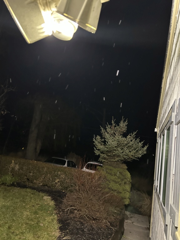
And I still don’t think Jan 4th for a few mood flakes is dead yet.
_________________
"In weather and in life, there's no winning and losing; there's only winning and learning."
WINTER 2012/2013 TOTALS 43.65"WINTER 2017/2018 TOTALS 62.85" WINTER 2022/2023 TOTALS 4.9"
WINTER 2013/2014 TOTALS 64.85"WINTER 2018/2019 TOTALS 14.25" WINTER 2023/2024 TOTALS 13.1"
WINTER 2014/2015 TOTALS 71.20"WINTER 2019/2020 TOTALS 6.35"
WINTER 2015/2016 TOTALS 35.00"WINTER 2020/2021 TOTALS 37.75"
WINTER 2016/2017 TOTALS 42.25"WINTER 2021/2022 TOTALS 31.65"

sroc4- Admin

- Posts : 8331
Reputation : 301
Join date : 2013-01-07
Location : Wading River, LI
rb924119 and weatherwatchermom like this post

1190ftalt- Pro Enthusiast

- Posts : 397
Reputation : 10
Join date : 2013-12-13
Location : Stillwater, NJ
amugs and rb924119 like this post
 Re: January 2024 Observations and Discussion
Hey, welcome to my neighborhood! Haha I’m 2.5 miles off the I-84 exit for Lake Wallenpaupack lol happy new year!
rb924119- Meteorologist

- Posts : 6890
Reputation : 194
Join date : 2013-02-06
Age : 32
Location : Greentown, Pa
1190ftalt likes this post
 Re: January 2024 Observations and Discussion
Oh I’m sorry, I meant I was following the clouds on radar and it was coming from Pennsylvania in the area of State College and Scranton, we just got some flurries here!rb924119 wrote:Hey, welcome to my neighborhood! Haha I’m 2.5 miles off the I-84 exit for Lake Wallenpaupack lol happy new year!
Anyhow HAPPY NEW YEAR !

1190ftalt- Pro Enthusiast

- Posts : 397
Reputation : 10
Join date : 2013-12-13
Location : Stillwater, NJ
 Re: January 2024 Observations and Discussion
Ok so for now lets go ahead and cont the discussions here for Late Sat & Sunday's Potential wintery event. Despite my overall joking posts last night, I do feel it necessary to reign myself in a bit here. In addition to along with CP's post regarding the cold water in the face reality check, th truth is we are still a fair amt of time away and we have all sseen wonderful things disappear before ur very eyes in less time.
Based on objective/subjective analysis I do spot a little wrinkle that perhaps may leave room for a negative trend with an in tighter to the coast storm track. Unfort I do feel it necessary to be pointed out, because again we are still technically around 4.5-5days out until first flakes which is alot of time for evolution to occur.
Now below are last nights 00z Euro followed by yesterdays 12z euro runs. Image is the 500mb anomaly maps. Notice how yesterday vs last nights run there is less of a block in the area labeled (1). Consequently the pv is a little less consolidated and organized.
Second: Look at the area labeled (2). This is the area that on the surface has our Polar HP, cold air source for the storm. Notice how there is a little less Orange on the eastern flank on 00z run and more so on 12z yest. area labeled (3) is our 50/50 low, and it too is a tad stronger but also slight further N compared to the prev run.
Both of these if cont to trend this way will allow less resistance against a storm track that wants to shift in tighter to the coast. Now there is no guarantee this will happen, OR that it will be enough to prevent a cold soln for all, but it is something I noticed and am doing my best to make sure that my bias doesnt completely take over the objective part of my mind.
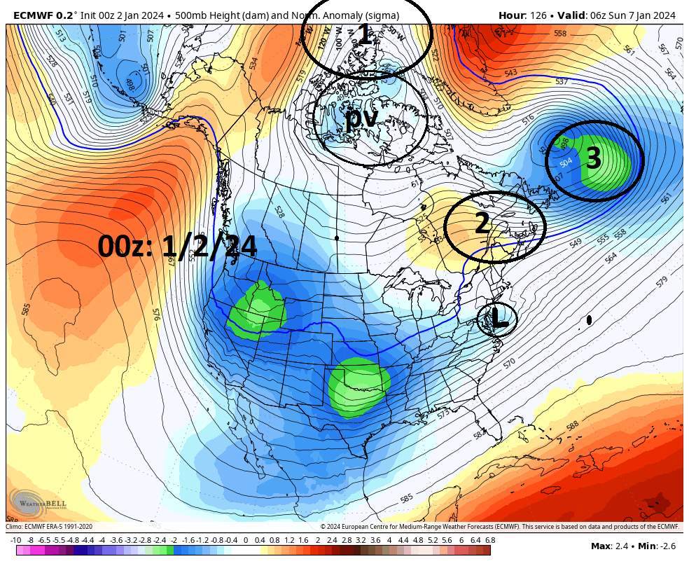

There is still ALOT to be excited about in this set up , but lets continue keep ourselves in relative check for the time being.
Based on objective/subjective analysis I do spot a little wrinkle that perhaps may leave room for a negative trend with an in tighter to the coast storm track. Unfort I do feel it necessary to be pointed out, because again we are still technically around 4.5-5days out until first flakes which is alot of time for evolution to occur.
Now below are last nights 00z Euro followed by yesterdays 12z euro runs. Image is the 500mb anomaly maps. Notice how yesterday vs last nights run there is less of a block in the area labeled (1). Consequently the pv is a little less consolidated and organized.
Second: Look at the area labeled (2). This is the area that on the surface has our Polar HP, cold air source for the storm. Notice how there is a little less Orange on the eastern flank on 00z run and more so on 12z yest. area labeled (3) is our 50/50 low, and it too is a tad stronger but also slight further N compared to the prev run.
Both of these if cont to trend this way will allow less resistance against a storm track that wants to shift in tighter to the coast. Now there is no guarantee this will happen, OR that it will be enough to prevent a cold soln for all, but it is something I noticed and am doing my best to make sure that my bias doesnt completely take over the objective part of my mind.


There is still ALOT to be excited about in this set up , but lets continue keep ourselves in relative check for the time being.
_________________
"In weather and in life, there's no winning and losing; there's only winning and learning."
WINTER 2012/2013 TOTALS 43.65"WINTER 2017/2018 TOTALS 62.85" WINTER 2022/2023 TOTALS 4.9"
WINTER 2013/2014 TOTALS 64.85"WINTER 2018/2019 TOTALS 14.25" WINTER 2023/2024 TOTALS 13.1"
WINTER 2014/2015 TOTALS 71.20"WINTER 2019/2020 TOTALS 6.35"
WINTER 2015/2016 TOTALS 35.00"WINTER 2020/2021 TOTALS 37.75"
WINTER 2016/2017 TOTALS 42.25"WINTER 2021/2022 TOTALS 31.65"

sroc4- Admin

- Posts : 8331
Reputation : 301
Join date : 2013-01-07
Location : Wading River, LI
 Re: January 2024 Observations and Discussion
26* for my low temperature this morning brrrr!
_________________
Mugs
AKA:King: Snow Weenie
Self Proclaimed
WINTER 2014-15 : 55.12" +.02 for 6 coatings (avg. 35")
WINTER 2015-16 Total - 29.8" (Avg 35")
WINTER 2016-17 : 39.5" so far

amugs- Advanced Forecaster - Mod

- Posts : 15093
Reputation : 213
Join date : 2013-01-07
Age : 54
Location : Hillsdale,NJ
 Re: January 2024 Observations and Discussion
1A & 1B are the two pieces of energy that will begin interacting by late Wed evening and possibly give a few folks some mood flakes early Thursday. It's these two pieces that come together and then shift NE and develop into our 50/50 upper level low. This is an integral part of the maturing of our -NAO block.
At the same time you can see where the energy that will be our Sunday storm currently sits off the west coast of NA, labeled 2, and where it enters the SW CONUS as we head into late Wednesday as well.
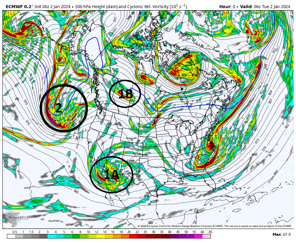

Point of this post is really to point out the fact that over the next 24-36 hrs all the energy begins to come ashore and interact with better sampling data for the models, so the Thursday 00z runs should be when we really start to truly begin to dial in some of the finer details. That said there will still be much to be taken from today and tonight's runs as well.
We Track
At the same time you can see where the energy that will be our Sunday storm currently sits off the west coast of NA, labeled 2, and where it enters the SW CONUS as we head into late Wednesday as well.


Point of this post is really to point out the fact that over the next 24-36 hrs all the energy begins to come ashore and interact with better sampling data for the models, so the Thursday 00z runs should be when we really start to truly begin to dial in some of the finer details. That said there will still be much to be taken from today and tonight's runs as well.
We Track

_________________
"In weather and in life, there's no winning and losing; there's only winning and learning."
WINTER 2012/2013 TOTALS 43.65"WINTER 2017/2018 TOTALS 62.85" WINTER 2022/2023 TOTALS 4.9"
WINTER 2013/2014 TOTALS 64.85"WINTER 2018/2019 TOTALS 14.25" WINTER 2023/2024 TOTALS 13.1"
WINTER 2014/2015 TOTALS 71.20"WINTER 2019/2020 TOTALS 6.35"
WINTER 2015/2016 TOTALS 35.00"WINTER 2020/2021 TOTALS 37.75"
WINTER 2016/2017 TOTALS 42.25"WINTER 2021/2022 TOTALS 31.65"

sroc4- Admin

- Posts : 8331
Reputation : 301
Join date : 2013-01-07
Location : Wading River, LI
rb924119, jmanley32 and heehaw453 like this post
 Re: January 2024 Observations and Discussion
Storms follow the thermal boundary of the oceans once they get out there - look at what we have set up and which way it should proceed, track.
The R/S line should be around the Driscoll Bridge area.
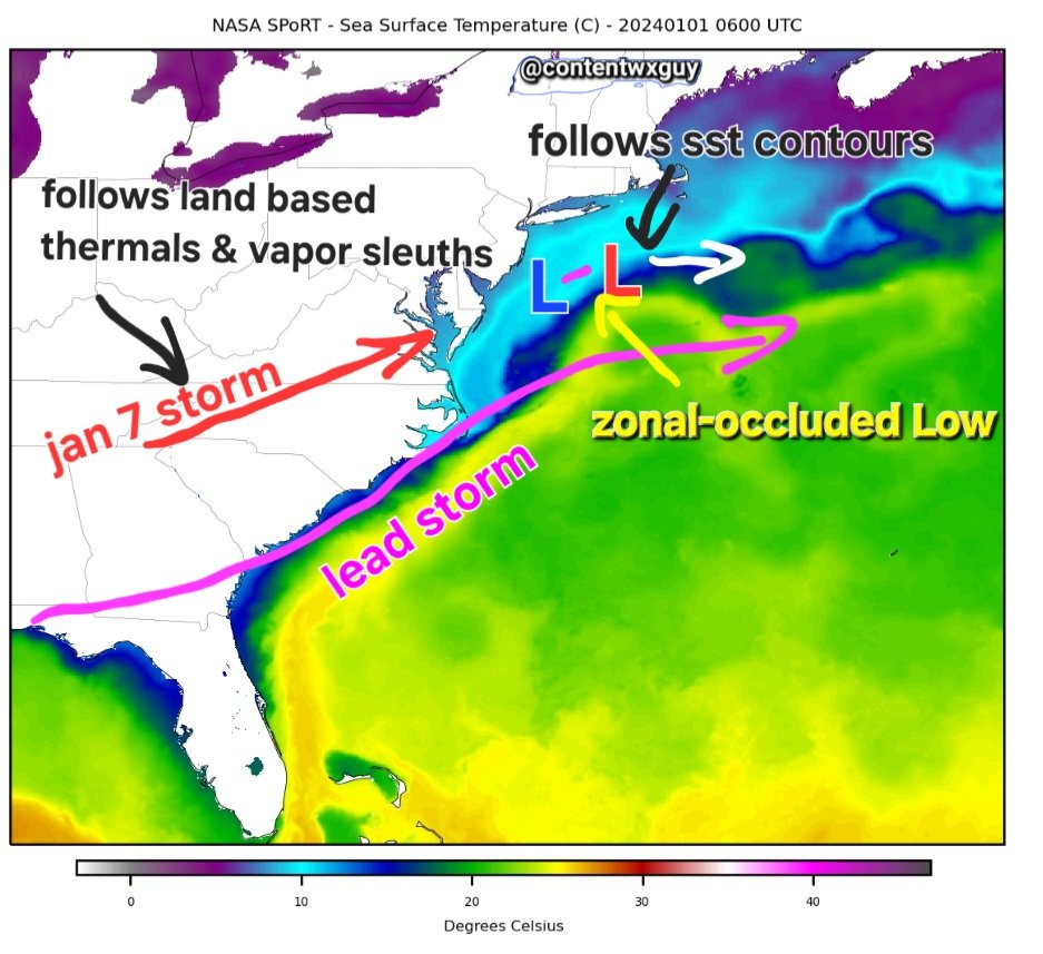
The R/S line should be around the Driscoll Bridge area.

_________________
Mugs
AKA:King: Snow Weenie
Self Proclaimed
WINTER 2014-15 : 55.12" +.02 for 6 coatings (avg. 35")
WINTER 2015-16 Total - 29.8" (Avg 35")
WINTER 2016-17 : 39.5" so far

amugs- Advanced Forecaster - Mod

- Posts : 15093
Reputation : 213
Join date : 2013-01-07
Age : 54
Location : Hillsdale,NJ
sroc4 likes this post
 Re: January 2024 Observations and Discussion
sroc4 wrote:Ok so for now lets go ahead and cont the discussions here for Late Sat & Sunday's Potential wintery event. Despite my overall joking posts last night, I do feel it necessary to reign myself in a bit here. In addition to along with CP's post regarding the cold water in the face reality check, th truth is we are still a fair amt of time away and we have all sseen wonderful things disappear before ur very eyes in less time.
Based on objective/subjective analysis I do spot a little wrinkle that perhaps may leave room for a negative trend with an in tighter to the coast storm track. Unfort I do feel it necessary to be pointed out, because again we are still technically around 4.5-5days out until first flakes which is alot of time for evolution to occur.
Now below are last nights 00z Euro followed by yesterdays 12z euro runs. Image is the 500mb anomaly maps. Notice how yesterday vs last nights run there is less of a block in the area labeled (1). Consequently the pv is a little less consolidated and organized.
Second: Look at the area labeled (2). This is the area that on the surface has our Polar HP, cold air source for the storm. Notice how there is a little less Orange on the eastern flank on 00z run and more so on 12z yest. area labeled (3) is our 50/50 low, and it too is a tad stronger but also slight further N compared to the prev run.
Both of these if cont to trend this way will allow less resistance against a storm track that wants to shift in tighter to the coast. Now there is no guarantee this will happen, OR that it will be enough to prevent a cold soln for all, but it is something I noticed and am doing my best to make sure that my bias doesnt completely take over the objective part of my mind.
There is still ALOT to be excited about in this set up , but lets continue keep ourselves in relative check for the time being.
Good post, Scott, but you gotta admit, it feels good to ACTUALLY be excited about something lol that said, I’m going to play devil’s advocate here. Let’s take a closer look at your graphics, specifically at your regions 2 (eastern Canadian ridge) and 3 (50/50 low). Note how region 3 trended significantly stronger, AND how there’s more negative anomaly further west in the newer run. 50N/50E is just a hair east of Newfoundland, maybe by 150 miles. So, this actually shows a trend of slowing the forward progression of that feature by keeping more of it back toward the 50/50 region. It also shows the trend of enhanced amplitude, both of which I mentioned earlier that are things we should see. Now, this directly translates to the number 3 region. Notice how that ridge is stronger, albeit with less of a run to run change than the trough, and it too is further west toward Hudson Bay (Hudson Bay block returns to the discussion, hehe). Think about what that means at the surface - you’re anchoring your high more to our direct north rather than to our north-northeast. Not only would enhance your cold advection, but it also forces more of an eastward trajectory of the surface low earlier as opposed to more of an east-northeast trajectory. And aloft, it forces the earlier change of the mid- and upper-level trough from its northeastward progression, to stopping the negatively tilted trough in its tracks, and then forcing it to squeeze southeast. You set that trough axis up further south like that, and more people snow. These changes are good things, in my opinion, not detrimental, and should eventually result in a southeastward nudge, with the jackpot centering on the I-95 corridor.
rb924119- Meteorologist

- Posts : 6890
Reputation : 194
Join date : 2013-02-06
Age : 32
Location : Greentown, Pa
 Re: January 2024 Observations and Discussion
rb924119 wrote:sroc4 wrote:Ok so for now lets go ahead and cont the discussions here for Late Sat & Sunday's Potential wintery event. Despite my overall joking posts last night, I do feel it necessary to reign myself in a bit here. In addition to along with CP's post regarding the cold water in the face reality check, th truth is we are still a fair amt of time away and we have all sseen wonderful things disappear before ur very eyes in less time.
Based on objective/subjective analysis I do spot a little wrinkle that perhaps may leave room for a negative trend with an in tighter to the coast storm track. Unfort I do feel it necessary to be pointed out, because again we are still technically around 4.5-5days out until first flakes which is alot of time for evolution to occur.
Now below are last nights 00z Euro followed by yesterdays 12z euro runs. Image is the 500mb anomaly maps. Notice how yesterday vs last nights run there is less of a block in the area labeled (1). Consequently the pv is a little less consolidated and organized.
Second: Look at the area labeled (2). This is the area that on the surface has our Polar HP, cold air source for the storm. Notice how there is a little less Orange on the eastern flank on 00z run and more so on 12z yest. area labeled (3) is our 50/50 low, and it too is a tad stronger but also slight further N compared to the prev run.
Both of these if cont to trend this way will allow less resistance against a storm track that wants to shift in tighter to the coast. Now there is no guarantee this will happen, OR that it will be enough to prevent a cold soln for all, but it is something I noticed and am doing my best to make sure that my bias doesnt completely take over the objective part of my mind.
There is still ALOT to be excited about in this set up , but lets continue keep ourselves in relative check for the time being.
Good post, Scott, but you gotta admit, it feels good to ACTUALLY be excited about something lol that said, I’m going to play devil’s advocate here. Let’s take a closer look at your graphics, specifically at your regions 2 (eastern Canadian ridge) and 3 (50/50 low). Note how region 3 trended significantly stronger, AND how there’s more negative anomaly further west in the newer run. 50N/50E is just a hair east of Newfoundland, maybe by 150 miles. So, this actually shows a trend of slowing the forward progression of that feature by keeping more of it back toward the 50/50 region. It also shows the trend of enhanced amplitude, both of which I mentioned earlier that are things we should see. Now, this directly translates to the number 3 region. Notice how that ridge is stronger, albeit with less of a run to run change than the trough, and it too is further west toward Hudson Bay (Hudson Bay block returns to the discussion, hehe). Think about what that means at the surface - you’re anchoring your high more to our direct north rather than to our north-northeast. Not only would enhance your cold advection, but it also forces more of an eastward trajectory of the surface low earlier as opposed to more of an east-northeast trajectory. And aloft, it forces the earlier change of the mid- and upper-level trough from its northeastward progression, to stopping the negatively tilted trough in its tracks, and then forcing it to squeeze southeast. You set that trough axis up further south like that, and more people snow. These changes are good things, in my opinion, not detrimental, and should eventually result in a southeastward nudge, with the jackpot centering on the I-95 corridor.
So I was playing devils advocate Ray. And believe me when I say I 100% see that as well, but wanted to simply point out that the other two things aren't positive. And yes it feels SO good to be excited about a set up for everyone. And thread the needle need not apply with this set up really. In the end I think its a mater of exact track, and the unfort sharp cutoffs that tend to come along with 25-50 miles differences in the track. Good problems to have.
_________________
"In weather and in life, there's no winning and losing; there's only winning and learning."
WINTER 2012/2013 TOTALS 43.65"WINTER 2017/2018 TOTALS 62.85" WINTER 2022/2023 TOTALS 4.9"
WINTER 2013/2014 TOTALS 64.85"WINTER 2018/2019 TOTALS 14.25" WINTER 2023/2024 TOTALS 13.1"
WINTER 2014/2015 TOTALS 71.20"WINTER 2019/2020 TOTALS 6.35"
WINTER 2015/2016 TOTALS 35.00"WINTER 2020/2021 TOTALS 37.75"
WINTER 2016/2017 TOTALS 42.25"WINTER 2021/2022 TOTALS 31.65"

sroc4- Admin

- Posts : 8331
Reputation : 301
Join date : 2013-01-07
Location : Wading River, LI
rb924119 likes this post
 Re: January 2024 Observations and Discussion
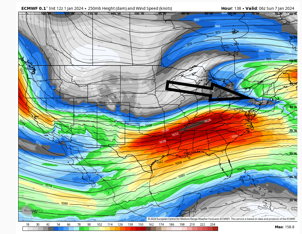
My key to this storm is how much phasing occurs with the jet streams. If there is interaction with the n/s in time then folks n/w of I95 have a shot at 1'. If not this will be 4-8" type of deal IMO.
The immediate jersey shore will rain for at least some of this holding down accumulations. The initial easterly fetch at the mid-levels coupled with warm SST waters will warm things. But even Ocean Cty IMO will pick up some accumulations.
The I95 has a shot at least 6" with this event into NYC and LI. But that IMO is less certain. I would not be comfortable saying that ATTM.

heehaw453- Advanced Forecaster

- Posts : 3906
Reputation : 86
Join date : 2014-01-20
Location : Bedminster Township, PA Elevation 600' ASL
CPcantmeasuresnow likes this post
 Re: January 2024 Observations and Discussion
FromMike Masco
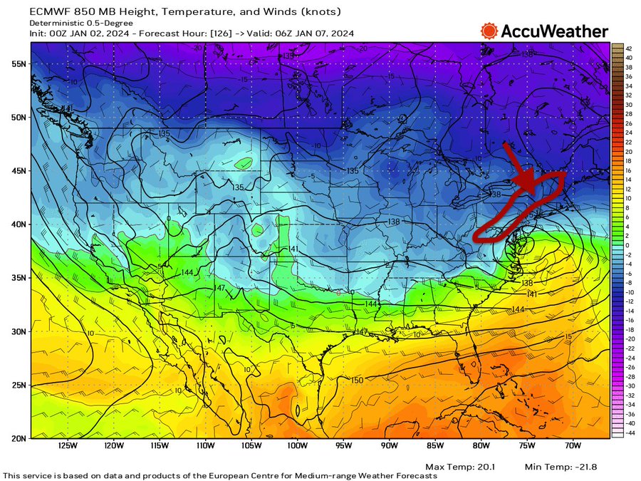
Your 850 CAD signature here - just NW of the 850 LP is where you see it dump in the circled region, I'd say shift that about 25 miles ESE. Great sign.
This is not a warm air mass only for SNJ is this but even then it may flip to snow as the low deepend and pulls off the coast
Dont underestimate the CAD signature with a 50/50 LP and a East Based Greenland Block.

_________________
Mugs
AKA:King: Snow Weenie
Self Proclaimed
WINTER 2014-15 : 55.12" +.02 for 6 coatings (avg. 35")
WINTER 2015-16 Total - 29.8" (Avg 35")
WINTER 2016-17 : 39.5" so far

amugs- Advanced Forecaster - Mod

- Posts : 15093
Reputation : 213
Join date : 2013-01-07
Age : 54
Location : Hillsdale,NJ
sroc4 likes this post
 Re: January 2024 Observations and Discussion
_________________
Mugs
AKA:King: Snow Weenie
Self Proclaimed
WINTER 2014-15 : 55.12" +.02 for 6 coatings (avg. 35")
WINTER 2015-16 Total - 29.8" (Avg 35")
WINTER 2016-17 : 39.5" so far

amugs- Advanced Forecaster - Mod

- Posts : 15093
Reputation : 213
Join date : 2013-01-07
Age : 54
Location : Hillsdale,NJ
 Re: January 2024 Observations and Discussion
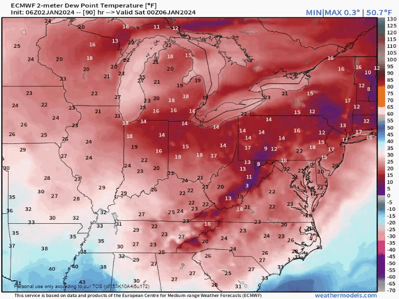
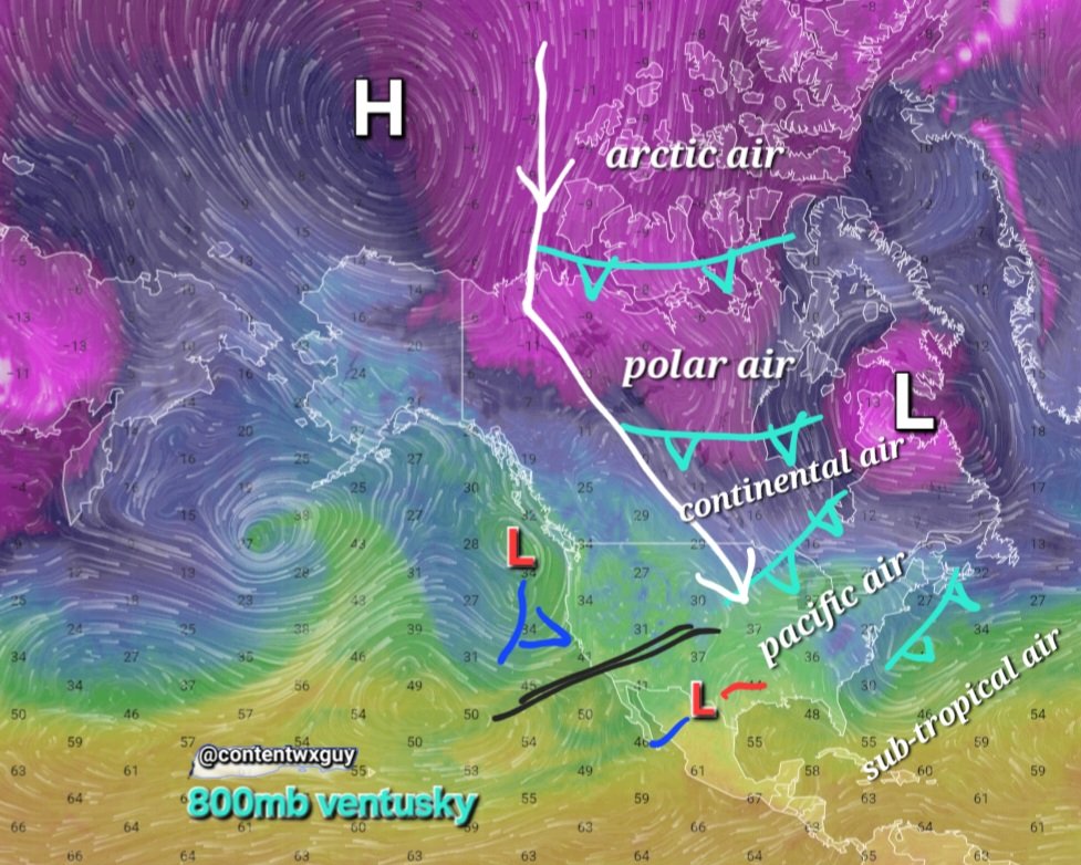
Beautiful NW polar and arctic flow incoming as noted on this map

_________________
Mugs
AKA:King: Snow Weenie
Self Proclaimed
WINTER 2014-15 : 55.12" +.02 for 6 coatings (avg. 35")
WINTER 2015-16 Total - 29.8" (Avg 35")
WINTER 2016-17 : 39.5" so far

amugs- Advanced Forecaster - Mod

- Posts : 15093
Reputation : 213
Join date : 2013-01-07
Age : 54
Location : Hillsdale,NJ
 Re: January 2024 Observations and Discussion
And there it is - GFS holds onto the primary into western PA/NY. Classic. God I hate that model. I really wish NCEP would get over their pride and just scrap the thing and start fresh. Yeah, it scores a victory every once in a while, but it’s pretty bad overall. I think a blind squirrel could do better.
rb924119- Meteorologist

- Posts : 6890
Reputation : 194
Join date : 2013-02-06
Age : 32
Location : Greentown, Pa
 Re: January 2024 Observations and Discussion
GEM held its course, which is fine with me. It’s evolution at least makes sense, even if I think it’s too high/tight with the track, personally.
rb924119- Meteorologist

- Posts : 6890
Reputation : 194
Join date : 2013-02-06
Age : 32
Location : Greentown, Pa
 Re: January 2024 Observations and Discussion
12z CMC and GFS looked identical and rained for immediate NYC metro. We need a tick SE
_________________
-Alex Iannone-

aiannone- Senior Enthusiast - Mod

- Posts : 4813
Reputation : 92
Join date : 2013-01-07
Location : Saint James, LI (Northwest Suffolk Co.)
 Re: January 2024 Observations and Discussion
I am going to reiterate and this IMO of course in order for this to work out well on the I95 and even n/w a bit from there this n/s has to drop lower and interact with the s/s. Why? It's not only igniting the storm to get the best dynamics, it's providing and reinforcing cold air. If this stays separate this IMO won't work out well for I95 and possibly a bit n/w of there.
The way this is modelled is a SNE/CNE big event.
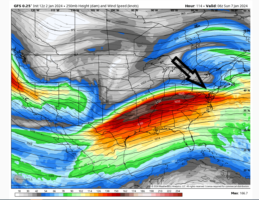
The way this is modelled is a SNE/CNE big event.

heehaw453- Advanced Forecaster

- Posts : 3906
Reputation : 86
Join date : 2014-01-20
Location : Bedminster Township, PA Elevation 600' ASL
rb924119 likes this post
 Re: January 2024 Observations and Discussion
aiannone wrote:12z CMC and GFS looked identical and rained for immediate NYC metro. We need a tick SE
I don't necessarily think a tick SE. I think it's missing the n/s involvement. This can change and I'd rather models be showing this 4 days out rather than 2 days out.
heehaw453- Advanced Forecaster

- Posts : 3906
Reputation : 86
Join date : 2014-01-20
Location : Bedminster Township, PA Elevation 600' ASL
rb924119 likes this post
 Re: January 2024 Observations and Discussion
aiannone wrote:12z CMC and GFS looked identical and rained for immediate NYC metro. We need a tick SE
Only at the surface. Aloft they were very different.
rb924119- Meteorologist

- Posts : 6890
Reputation : 194
Join date : 2013-02-06
Age : 32
Location : Greentown, Pa
 Re: January 2024 Observations and Discussion
While the GFS got warmer due to the primary low further north, the CMC is south and colder and is a big hit for a lot of us. Not surprising though. Expect the waffling with the models to continue for the next 48 hours then thereafter we’ll start to hone in on a solution.

nutleyblizzard- Senior Enthusiast

- Posts : 1952
Reputation : 41
Join date : 2014-01-30
Age : 58
Location : Nutley, new jersey
rb924119 likes this post
 Re: January 2024 Observations and Discussion
heehaw453 wrote:I am going to reiterate and this IMO of course in order for this to work out well on the I95 and even n/w a bit from there this n/s has to drop lower and interact with the s/s. Why? It's not only igniting the storm to get the best dynamics, it's providing and reinforcing cold air. If this stays separate this IMO won't work out well for I95 and possibly a bit n/w of there.
The way this is modelled is a SNE/CNE big event.
Overall I agree with you. I don’t think this depiction is accurate, though. I was looking this morning, and you’re advecting what’s now approximately 1.5-sigma PWAT (was previously approximately 1-sigma, so here comes our expected moisture increase) into this thing. Now you force that to rise……does it really make sense that you won’t induce an anomalous jet to the north/northeast in response to the diabatic heat release from condensing all that water vapor? Sorry, I don’t buy it, and I think we see that northern jet start appearing on future runs. The GEM looks a lot better to me.
rb924119- Meteorologist

- Posts : 6890
Reputation : 194
Join date : 2013-02-06
Age : 32
Location : Greentown, Pa
 Re: January 2024 Observations and Discussion
rb924119 wrote:heehaw453 wrote:I am going to reiterate and this IMO of course in order for this to work out well on the I95 and even n/w a bit from there this n/s has to drop lower and interact with the s/s. Why? It's not only igniting the storm to get the best dynamics, it's providing and reinforcing cold air. If this stays separate this IMO won't work out well for I95 and possibly a bit n/w of there.
The way this is modelled is a SNE/CNE big event.
Overall I agree with you. I don’t think this depiction is accurate, though. I was looking this morning, and you’re advecting what’s now approximately 1.5-sigma PWAT (was previously approximately 1-sigma, so here comes our expected moisture increase) into this thing. Now you force that to rise……does it really make sense that you won’t induce an anomalous jet to the north/northeast in response to the diabatic heat release from condensing all that water vapor? Sorry, I don’t buy it, and I think we see that northern jet start appearing on future runs. The GEM looks a lot better to me.
I agree with you Rb. I think they're going to waffle a bit on that especially at this range. But that IMO is the wild card with this thing. If we get that set this has very high potential. Like what Frank calls Godzilla.
heehaw453- Advanced Forecaster

- Posts : 3906
Reputation : 86
Join date : 2014-01-20
Location : Bedminster Township, PA Elevation 600' ASL
rb924119 likes this post
 Re: January 2024 Observations and Discussion
And Rb you are right I just looked at the GEM and it's improved.
heehaw453- Advanced Forecaster

- Posts : 3906
Reputation : 86
Join date : 2014-01-20
Location : Bedminster Township, PA Elevation 600' ASL
docstox12 and rb924119 like this post
Page 1 of 26 • 1, 2, 3 ... 13 ... 26 
Page 1 of 26
Permissions in this forum:
You cannot reply to topics in this forum|
|
|

 Home
Home