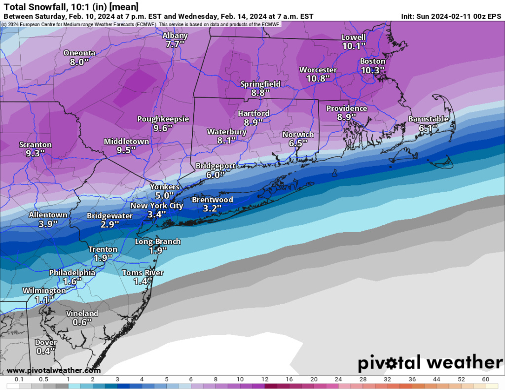
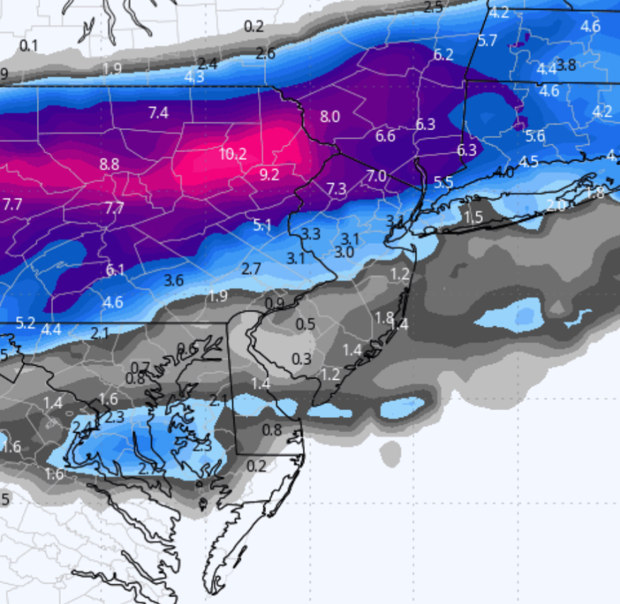
February 12th-13th 2024 Pre-Valentines Day Storm Potential
+31
richb521
brownie
Carvin
silentwreck
dkodgis
NJBear
essexcountypete
amugs
tomsriversnowstorm
aiannone
SENJsnowman
jmanley32
nutleyblizzard
dsix85
docstox12
toople
Irish
Dunnzoo
Koroptim
phil155
Frank_Wx
MattyICE
billg315
frank 638
hyde345
SNOW MAN
Artechmetals
CPcantmeasuresnow
heehaw453
JT33
sroc4
35 posters
Page 3 of 13
Page 3 of 13 •  1, 2, 3, 4 ... 11, 12, 13
 Re: February 12th-13th 2024 Pre-Valentines Day Storm Potential
WSW for my area, 5 to 9 inches with 10 locally possible.Colder weather after the snowstorm will make a snowpack possible.
Bernie's map on Accuweather went from 1-3 for me to now 6-12.
Bernie's map on Accuweather went from 1-3 for me to now 6-12.
docstox12- Wx Statistician Guru

- Posts : 8507
Join date : 2013-01-07
CPcantmeasuresnow likes this post
 Re: February 12th-13th 2024 Pre-Valentines Day Storm Potential
It's painfully close. This storm will agonize many folks on the is board including myself.
heehaw453- Advanced Forecaster

- Posts : 3906
Join date : 2014-01-20
kalleg and essexcountypete like this post
 Re: February 12th-13th 2024 Pre-Valentines Day Storm Potential
Sroc- feel like we are in the cross hairs around Wading River/Manorville. Do we reap the benefits of this bombing out as it pulls away and get rocked by one of the CCB or do we battle r/s for the large majority of the storm? Guess we will find out.
dsix85- Pro Enthusiast

- Posts : 349
Reputation : 8
Join date : 2014-01-01
Location : New York
 Re: February 12th-13th 2024 Pre-Valentines Day Storm Potential
Looks like CNJ and south (Coastal plain), could see some heavy rain (maybe up to an inch) overnight Monday and then a coating to a couple inches of snow Tuesday morning (probably on the grass).

Irish- Pro Enthusiast

- Posts : 788
Reputation : 19
Join date : 2019-01-16
Age : 45
Location : Old Bridge, NJ
phil155 likes this post
 Re: February 12th-13th 2024 Pre-Valentines Day Storm Potential
_________________
_______________________________________________________________________________________________________
CLICK HERE to view NJ Strong Snowstorm Classifications
 Re: February 12th-13th 2024 Pre-Valentines Day Storm Potential
dsix85 wrote:Sroc- feel like we are in the cross hairs around Wading River/Manorville. Do we reap the benefits of this bombing out as it pulls away and get rocked by one of the CCB or do we battle r/s for the large majority of the storm? Guess we will find out.
Unfortunately I’m in the camp of battling R/S Lines. As usual the general statement of “shift to the storm track N or S by as little as 25-35miles could be the difference between white rain to a coating to 3-5”. I think it’s that close for us. Looks like LI could literally be broken down to three zones. North of Rte 25. Between 25 and say 1-2 miles south of 495, and then south of that. Further north you go better chance for accumulation. I think it’s that close for us. That said with recent winter trends towards the warmer solns for the coastal plain in tight, this out come was foreseen. The margins are still close enough and there is still some time, all day today and tomorrow, to still pay attention too but…I’m not putting gas in my snowblower.
_________________
"In weather and in life, there's no winning and losing; there's only winning and learning."
WINTER 2012/2013 TOTALS 43.65"WINTER 2017/2018 TOTALS 62.85" WINTER 2022/2023 TOTALS 4.9"
WINTER 2013/2014 TOTALS 64.85"WINTER 2018/2019 TOTALS 14.25" WINTER 2023/2024 TOTALS 13.1"
WINTER 2014/2015 TOTALS 71.20"WINTER 2019/2020 TOTALS 6.35"
WINTER 2015/2016 TOTALS 35.00"WINTER 2020/2021 TOTALS 37.75"
WINTER 2016/2017 TOTALS 42.25"WINTER 2021/2022 TOTALS 31.65"

sroc4- Admin

- Posts : 8331
Reputation : 301
Join date : 2013-01-07
Location : Wading River, LI
 Re: February 12th-13th 2024 Pre-Valentines Day Storm Potential
Overnight summary:
6z Euro about the same.
6z NAM took a step back closer to where it was at 18z than 0z.
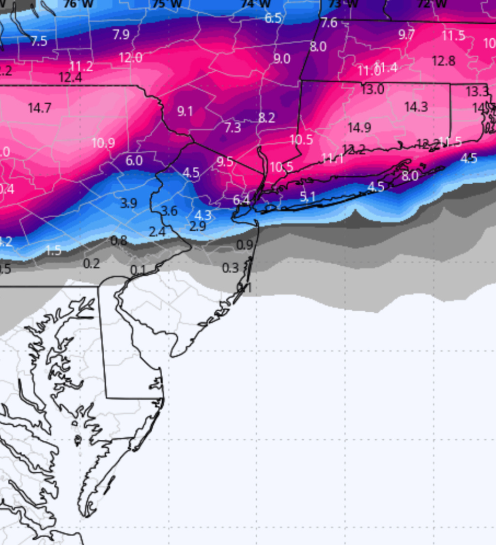
6z GFS was a slight improvement just a tick south so some areas of Central NJ/immediate NYC area that were looking at an inch or so on the 0z are now getting a few inches. Here is 6z GFS vs 0z GFS snowfall map:
6z (current)
0z (previous):
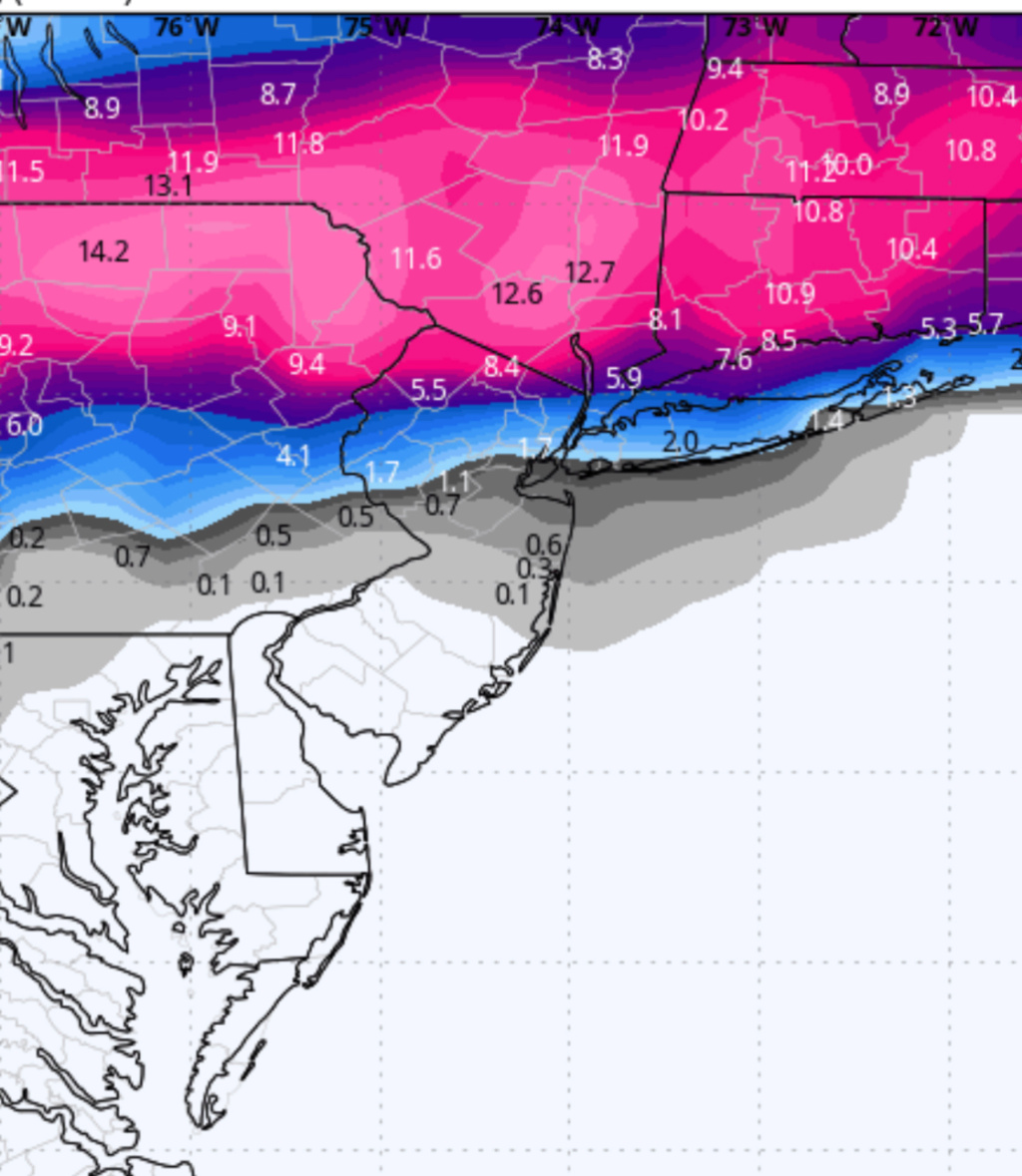
This tick south is very much like what happened with the NAM last evening, but the GFS was not as good to begin with so for people in south Jersey and southern Central NJ not as sig an improvement.
IMO this is where we are. These models are going to shift back and forth for the next 24-hours. I wouldn’t expect a major earth-shaking shift (ie don’t expect South Jersey to jackpot). But as you can see from the above, even the smallest of shifts for people on the southern edge of this is the difference between 1-2” and 6-7”. Unfortunately I doubt if you’re in one of those borderline areas you’re going to see any model run today that will be clear cut enough for you to conclude which side of that coin you’ll be on. This is a very sharp cutoff from significant to nuisance
And luckily for the weather services : that drastic cutoff runs right through an area with about 15-20 million people affected (Philly to Central NJ to NYC to LI).
6z Euro about the same.
6z NAM took a step back closer to where it was at 18z than 0z.
6z GFS was a slight improvement just a tick south so some areas of Central NJ/immediate NYC area that were looking at an inch or so on the 0z are now getting a few inches. Here is 6z GFS vs 0z GFS snowfall map:
6z (current)

0z (previous):

This tick south is very much like what happened with the NAM last evening, but the GFS was not as good to begin with so for people in south Jersey and southern Central NJ not as sig an improvement.
IMO this is where we are. These models are going to shift back and forth for the next 24-hours. I wouldn’t expect a major earth-shaking shift (ie don’t expect South Jersey to jackpot). But as you can see from the above, even the smallest of shifts for people on the southern edge of this is the difference between 1-2” and 6-7”. Unfortunately I doubt if you’re in one of those borderline areas you’re going to see any model run today that will be clear cut enough for you to conclude which side of that coin you’ll be on. This is a very sharp cutoff from significant to nuisance
And luckily for the weather services : that drastic cutoff runs right through an area with about 15-20 million people affected (Philly to Central NJ to NYC to LI).

billg315- Advanced Forecaster - Mod

- Posts : 4469
Reputation : 185
Join date : 2015-01-24
Age : 50
Location : Flemington, NJ
sroc4 and silentwreck like this post
 Re: February 12th-13th 2024 Pre-Valentines Day Storm Potential
The critical layer will be between 800-850. Any slight deviation in the ULL will have big impacts on who sees snow vs rain. If the 850 passes a hair more south and closes off early, then central NJ can see 3-6" from this. If not then c-1" on the grass. North Shore of LI too IMO could see 3-6" is above holds. The model will have error one way or the other and these types of systems will have surprises right to go time.
06Z Euro. Drop the energy 50 miles and above would hold.

06Z Euro. Drop the energy 50 miles and above would hold.

heehaw453- Advanced Forecaster

- Posts : 3906
Reputation : 86
Join date : 2014-01-20
Location : Bedminster Township, PA Elevation 600' ASL
sroc4, weatherwatchermom and billg315 like this post
 Re: February 12th-13th 2024 Pre-Valentines Day Storm Potential
Sooo Close.heehaw453 wrote:The critical layer will be between 800-850. Any slight deviation in the ULL will have big impacts on who sees snow vs rain. If the 850 passes a hair more south and closes off early, then central NJ can see 3-6" from this. If not then c-1" on the grass. North Shore of LI too IMO could see 3-6" is above holds. The model will have error one way or the other and these types of systems will have surprises right to go time.
06Z Euro. Drop the energy 50 miles and above would hold.

nutleyblizzard- Senior Enthusiast

- Posts : 1952
Reputation : 41
Join date : 2014-01-30
Age : 58
Location : Nutley, new jersey
 Re: February 12th-13th 2024 Pre-Valentines Day Storm Potential
Funny there isn't even a Hazardous Weather Outlook for my area in NENJ. Maybe they're not sure if we are going to be included in the watch area to our west or not. 
_________________
Janet
Snowfall winter of 2023-2024 17.5"
Snowfall winter of 2022-2023 6.0"
Snowfall winter of 2021-2022 17.6" 1" sleet 2/25/22
Snowfall winter of 2020-2021 51.1"
Snowfall winter of 2019-2020 8.5"
Snowfall winter of 2018-2019 25.1"
Snowfall winter of 2017-2018 51.9"
Snowfall winter of 2016-2017 45.6"
Snowfall winter of 2015-2016 29.5"
Snowfall winter of 2014-2015 50.55"
Snowfall winter of 2013-2014 66.5"
Dunnzoo- Senior Enthusiast - Mod

- Posts : 4892
Reputation : 68
Join date : 2013-01-11
Age : 62
Location : Westwood, NJ
 Re: February 12th-13th 2024 Pre-Valentines Day Storm Potential
NE NJ certainly not likely to be in any more than an advisory unless there are shifts.
MattyICE- Advanced Forecaster

- Posts : 249
Reputation : 6
Join date : 2017-11-10
Age : 38
Location : Clifton, NJ (Eastern Passaic County)
 Re: February 12th-13th 2024 Pre-Valentines Day Storm Potential
Right on cue 12z NAM shifts again. Brings significant snow line back south closer to where last nights 0z run was. Honestly the Low looks a little more tucked on this run, but it also is slower to leave with backside snows and is plenty cold.

billg315- Advanced Forecaster - Mod

- Posts : 4469
Reputation : 185
Join date : 2015-01-24
Age : 50
Location : Flemington, NJ
 Re: February 12th-13th 2024 Pre-Valentines Day Storm Potential
12zNam looks great for northern half of NJ. Widespread warning criteria snows.MattyICE wrote:NE NJ certainly not likely to be in any more than an advisory unless there are shifts.

nutleyblizzard- Senior Enthusiast

- Posts : 1952
Reputation : 41
Join date : 2014-01-30
Age : 58
Location : Nutley, new jersey

billg315- Advanced Forecaster - Mod

- Posts : 4469
Reputation : 185
Join date : 2015-01-24
Age : 50
Location : Flemington, NJ
 Re: February 12th-13th 2024 Pre-Valentines Day Storm Potential
what do you think are the chances southern westchester, which is due east across the hudson from NE NJ is able to get a warning level snow? Rn like zoo said not even a hwo. Shes prolly right that nws isnt sure but its odd that there isnt even a hwo suggesting snow is even a possibility. Verbatim that nsm run gives me 6 to 8 but is there any confidence on that at all. Hate these razor shap cut off storms. Os it possible it slips further south?nutleyblizzard wrote:12zNam looks great for northern half of NJ. Widespread warning criteria snows.MattyICE wrote:NE NJ certainly not likely to be in any more than an advisory unless there are shifts.

jmanley32- Senior Enthusiast

- Posts : 20517
Reputation : 108
Join date : 2013-12-12
Age : 42
Location : Yonkers, NY
 Re: February 12th-13th 2024 Pre-Valentines Day Storm Potential
nutleyblizzard wrote:12zNam looks great for northern half of NJ. Widespread warning criteria snows.MattyICE wrote:NE NJ certainly not likely to be in any more than an advisory unless there are shifts.
I hope it’s true! I’d love to be wrong. I’d like to be optimistic but based on the type of storm
This is I think the northern push is strong and real. But they’re still two full days and I suppose the NAM could have credence, but I simply don’t trust it as it’s still out of range and should not be trusted. If it’s showing this in 24 hours ANd the 3K is by Monday afternoon I’ll be more optimistic.
MattyICE- Advanced Forecaster

- Posts : 249
Reputation : 6
Join date : 2017-11-10
Age : 38
Location : Clifton, NJ (Eastern Passaic County)
billg315 likes this post
 Re: February 12th-13th 2024 Pre-Valentines Day Storm Potential
By now, every single model has turned against the Jersey Shore. So, we’ll have to hope for miracles for this storm, but more realistically hope for better final outcomes for the next storm (which you’d have to figure starts with an assumption of that not working out either). I suppose Long Branch is far enough north that it might score an inch or 2 out of this deal, but that would actually be close to a miracle outcome at this point. Ok, it is what it is, and with the one small-medium exception of 1/19 that’s what it has been for the whole season, for the Shore and points further north and west too. Best of luck to those in the zone this time. Looks like qpf calls are up a bit, so those that stay all snow could do quite well yet.
SENJsnowman- Senior Enthusiast

- Posts : 1186
Reputation : 61
Join date : 2017-01-06
Age : 51
Location : Bayville, NJ
weatherwatchermom and billg315 like this post
 Re: February 12th-13th 2024 Pre-Valentines Day Storm Potential
Yeah I wouldn’t put my eggs in the NAM basket with this setup. But I wouldn’t write it off either. Have to let the next 24-36 hours play out. To quote a wise man, We Track!

billg315- Advanced Forecaster - Mod

- Posts : 4469
Reputation : 185
Join date : 2015-01-24
Age : 50
Location : Flemington, NJ
 Re: February 12th-13th 2024 Pre-Valentines Day Storm Potential
jmanley32 wrote:what do you think are the chances southern westchester, which is due east across the hudson from NE NJ is able to get a warning level snow? Rn like zoo said not even a hwo. Shes prolly right that nws isnt sure but its odd that there isnt even a hwo suggesting snow is even a possibility. Verbatim that nsm run gives me 6 to 8 but is there any confidence on that at all. Hate these razor shap cut off storms. Os it possible it slips further south?nutleyblizzard wrote:12zNam looks great for northern half of NJ. Widespread warning criteria snows.MattyICE wrote:NE NJ certainly not likely to be in any more than an advisory unless there are shifts.
I mean it’s possible sure. But this is another storm where the track can look mint and it still would struggle to provide solid snow where it “should” based on a solid track. I’m being conservative literally until game time on this one. I don’t even care if the NAM gives us a foot today tbh.
MattyICE- Advanced Forecaster

- Posts : 249
Reputation : 6
Join date : 2017-11-10
Age : 38
Location : Clifton, NJ (Eastern Passaic County)
jmanley32 likes this post
 Re: February 12th-13th 2024 Pre-Valentines Day Storm Potential
If it makes you feel any better SENJ Snowman, in our last storm in mid-Jan my friends at the shore south of you got about 5” of snow when I was struggling to get 1-2”. If the GFS/Euro are right my friends in far North Jersey may get 5” while I struggle to get 1-2”. So each storm has its winners and losers.As you say, it is what it is.

billg315- Advanced Forecaster - Mod

- Posts : 4469
Reputation : 185
Join date : 2015-01-24
Age : 50
Location : Flemington, NJ
SENJsnowman likes this post
 Re: February 12th-13th 2024 Pre-Valentines Day Storm Potential
I’m just trying to be as balanced as possible. One trend this winter that could help here is storms have tended to de-amplify on approach. That can lead to losing them to our general south or just shearing them out into a weaker mess. If that happens here we would want to see it across guidance today and maybe it can help. Intrigued to see what the Euro does later. Then mesos overnight.
MattyICE- Advanced Forecaster

- Posts : 249
Reputation : 6
Join date : 2017-11-10
Age : 38
Location : Clifton, NJ (Eastern Passaic County)
 Re: February 12th-13th 2024 Pre-Valentines Day Storm Potential
billg315 wrote:If it makes you feel any better SENJ Snowman, in our last storm in mid-Jan my friends at the shore south of you got about 5” of snow when I was struggling to get 1-2”. If the GFS/Euro are right my friends in far North Jersey may get 5” while I struggle to get 1-2”. So each storm has its winners and losers.As you say, it is what it is.
The part about the southern section doing well felt good, but I’d rather part of the board does well and the other parts do better! Ha ha!
I think I’ll light up the grill, put down some chicken wings and a little Chuck roast for beef nachos. That’ll make me feel better!
SENJsnowman- Senior Enthusiast

- Posts : 1186
Reputation : 61
Join date : 2017-01-06
Age : 51
Location : Bayville, NJ
essexcountypete and billg315 like this post
 Re: February 12th-13th 2024 Pre-Valentines Day Storm Potential
There is clearly a tick south with all of the 12z runs. GEFS as well. Will be interesting to see if overnight we cont to tick south vs windshield wiper back north. Yeah. With the depth of cold to our north a colder soln wouldn’t surprise me. But with trends this winter neither would the warmer soln.
_________________
"In weather and in life, there's no winning and losing; there's only winning and learning."
WINTER 2012/2013 TOTALS 43.65"WINTER 2017/2018 TOTALS 62.85" WINTER 2022/2023 TOTALS 4.9"
WINTER 2013/2014 TOTALS 64.85"WINTER 2018/2019 TOTALS 14.25" WINTER 2023/2024 TOTALS 13.1"
WINTER 2014/2015 TOTALS 71.20"WINTER 2019/2020 TOTALS 6.35"
WINTER 2015/2016 TOTALS 35.00"WINTER 2020/2021 TOTALS 37.75"
WINTER 2016/2017 TOTALS 42.25"WINTER 2021/2022 TOTALS 31.65"

sroc4- Admin

- Posts : 8331
Reputation : 301
Join date : 2013-01-07
Location : Wading River, LI
kalleg, jmanley32, weatherwatchermom and billg315 like this post
 Re: February 12th-13th 2024 Pre-Valentines Day Storm Potential
sroc4 wrote:There is clearly a tick south with all of the 12z runs. GEFS as well. Will be interesting to see if overnight we cont to tick south vs windshield wiper back north. Yeah. With the depth of cold to our north a colder soln wouldn’t surprise me. But with trends this winter neither would the warmer soln.
Agree 100%. I see a CCB feature developing on this. There's evidence of an h5 close off too before it gets to the coast. That consolidation would further support a colder scenario. Going to be close. Expectations in check.
heehaw453- Advanced Forecaster

- Posts : 3906
Reputation : 86
Join date : 2014-01-20
Location : Bedminster Township, PA Elevation 600' ASL
sroc4, kalleg, weatherwatchermom and SENJsnowman like this post
 Re: February 12th-13th 2024 Pre-Valentines Day Storm Potential
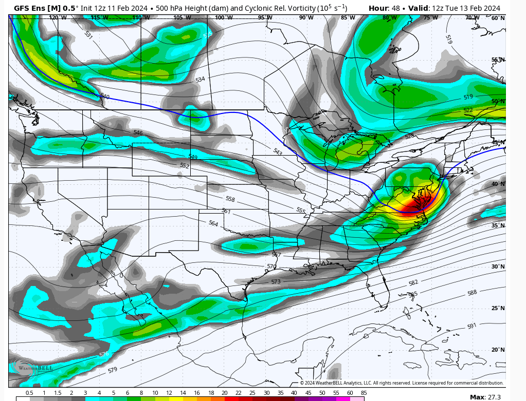
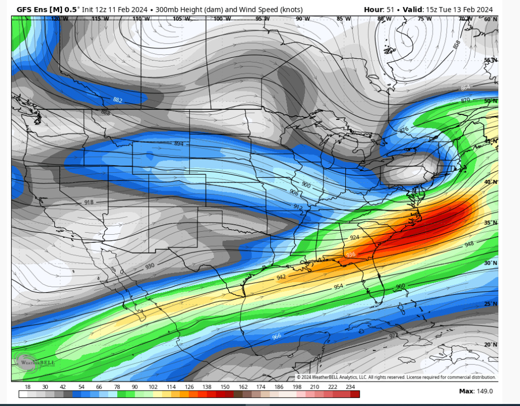
A few comments on the GEFS.
1/this is going to have a lot of QPF
2/it's going to deepen rapidly
3/the trough going over the Delmarva is favorable from I78 on northward
4/the tilt of the trough is negative
1st picture
The sharp negative tilt on a mean is indicative of a rapidly intensifying short wave. That doesn't occur unless it's consolidated. As the storm hits the coast it will crash the mid-levels. I wouldn't be surprised to see mid-levels close off before hitting the coast.
2nd picture
where you see the white is direct n/s engagement to the storm. That is cold and it's why we are seeing evidence of a closed off ULL. At that latitude is IMO where there could be very strong snowfall rates for a time. It could be most extreme in Poconos and work down from there.


heehaw453- Advanced Forecaster

- Posts : 3906
Reputation : 86
Join date : 2014-01-20
Location : Bedminster Township, PA Elevation 600' ASL
sroc4 likes this post
 Re: February 12th-13th 2024 Pre-Valentines Day Storm Potential
This n/s wild card has sucked me back in. 
heehaw453- Advanced Forecaster

- Posts : 3906
Reputation : 86
Join date : 2014-01-20
Location : Bedminster Township, PA Elevation 600' ASL
weatherwatchermom and SENJsnowman like this post
 Re: February 12th-13th 2024 Pre-Valentines Day Storm Potential
know its impossible to know where ccb sets up but does it have any chsnce to be nj to nyc and ne?heehaw453 wrote:sroc4 wrote:There is clearly a tick south with all of the 12z runs. GEFS as well. Will be interesting to see if overnight we cont to tick south vs windshield wiper back north. Yeah. With the depth of cold to our north a colder soln wouldn’t surprise me. But with trends this winter neither would the warmer soln.
Agree 100%. I see a CCB feature developing on this. There's evidence of an h5 close off too before it gets to the coast. That consolidation would further support a colder scenario. Going to be close. Expectations in check.

jmanley32- Senior Enthusiast

- Posts : 20517
Reputation : 108
Join date : 2013-12-12
Age : 42
Location : Yonkers, NY
Page 3 of 13 •  1, 2, 3, 4 ... 11, 12, 13
Page 3 of 13
Permissions in this forum:
You cannot reply to topics in this forum|
|
|

 Home
Home