
 Search
Current date/time is Fri May 10, 2024 2:36 am
Search found 3 matches for 4
FEB 13th Pre V-Day Storm Part II
Man oh man does it feel like technology in this industry is taking a step backward instead of forward? That is a conversation for a different day, but the forecast accuracy at 1, 2, 3, etc. days of lead time must be absolutely dreadful on some of these models. The inconsistency and volatility is enough to drive someone mad!
This is a look at the 500mb set-up valid later this afternoon. Our storm is collecting itself and absorbing gulf moisture near the TN valley. The trough is neutrally tilted. One thing you will notice is the size of the trough is smaller compared to prior east coast snowstorms. In general, the 500mb flow is lacking amplification due to the progressiveness we continue to see out of the Pacific. This will not be a full-scale Miller A. It is purely southern stream driven. More importantly, the PV is situated in SE Canada and pressing south. This feature keeps our storm track to our south versus cutting to our west, while also acting as wall to keep the colder air mass in place. What is not clearly visible in this image is that northern s/w energy which is crossing into the Great Lakes. Unfortunately, and I'll touch on this some more, instead of being the complimentary phasing energy it may end up acting as a "kicker" that shuns our storm more south & east.

By the time we get to Tuesday morning - valid 10am on the 12z GFS - the trough is already off the coast and the 500mb low closed off south of Long Island. This is a very ideal track of the 500mb low and often times leads to the development of a CCB. This is the "madonne" band that drops 2-3" of snow per hour and can really bury people in a short period of time. One thing to note and I will mention again later is the speed this storm is moving in. It goes from TN to Long Island in record speed. Sadly, we do not have any high latitude blocking to help slow this thing down.
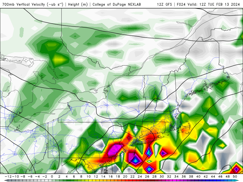
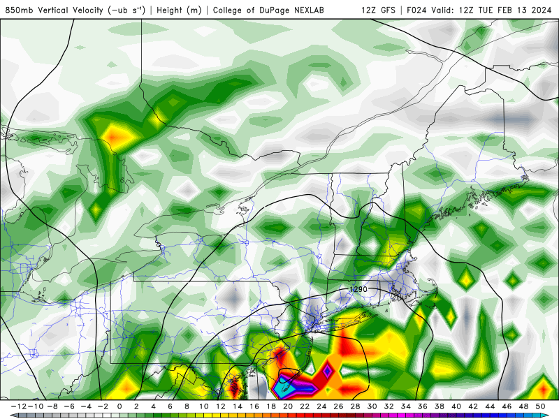
The other thing we look for when it comes to northeast snowstorms is the position of the mid-level low's and whether or not they are vertically stacked. These are the 700mb (top) and 850mb (bottom) lows. You can see the 700mb low is fairly obtuse and covers a large area. The VV's are pretty scattered due to how disorganized everything looks aloft. Nevertheless, there is sufficient forcing entrenched within the low to promote high intensity precip rates. On the other hand, the 850mb low is a little more organized and you can see the low level circulation closed just north of Cape May, NJ. The vertical velocity here is much more concentrated than 700mb and wraps around the LLC nicely.

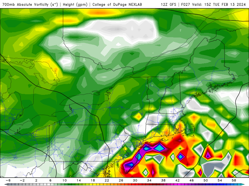
Here's a closer look at the GFS 700mb vorticity output valid for 7am (top) and 10am (bottom). These are the hours models are showing the heaviest precip falling. You can tell, especially from the bottom image, the vorticity is trying to organize itself along the immediate coast, NYC and Long Island. However, in the first picture you can see there are some white/grey colors that appear in parts of NJ (shore points). This actually is subsidence that happens when you are wedged between two areas of VV to your north/south or east/west.
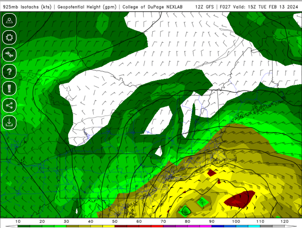
Last thing I want to highlight are the winds at 925mb level. This is valid for 7am, which again is when models (in this case, GFS) have prolific snow falling over the coastal section. One thing you will notice is the wind direction will be out of the east through this evening, then gradually turn northeast by 5-6am tomorrow morning. Eventually the winds turn out of the NW once the low gets into our latitude and begins to pull away east-northeast. It's important to call out the easterly winds that will try to be pesky in keeping the surface temperatures above freezing.

This is why when you compare a regular 10:1 snow map versus a Kuchera 10:1 snowmap, you will see the Kuchera map is actually lower in some parts of the area because its algorithm takes into snow ratios and marginal temps. Above is the snow ratio projection by the EURO valid for 7am Tuesday. Along the coast, ratios range from 5:1 to 7:1. Even N&W of NYC is not seeing exact 10:1 ratios. That said, you can counteract the lower ratios and still achieve impressive snow accumulation through banding (CCB) and frontogenesis (forcing) between 700mb-850mb. But ratios need to be considered in the forecast.
These are the main reasons why my snow map appears lighter than models in terms of accumulations:
1. Duration - very fast. We will change to snow in the overnight hours (closer to sunrise) and precip will be done around lunch time (say 12pm) on Tuesday. Read point #4 to get a better sense of why this is a fast mover.
2. Subsidence - difficult to predict but there are signs that certain areas, especially toward western portions of NJ, will experience it which will cut down on snowfall amounts. I'm not a fan of how scattered all the mid and upper level vorticity is
3. Temperatures - we're getting into the low 40's today and we're dealing with easterly winds through 7am at a minimum. This will keep the surface above freezing. Ratios between 5:1 and 8:1 (6:1 for NYC).
4. Storm track - I can't help but look at the UKMET and EURO and consider their more "southern" track. It would contradict some of the things I mentioned, such as the cold press, northern s/w "kicker" and progressiveness in the overall flow across the country (neutral PNA, collapsing -EPO)

- on Mon Feb 12, 2024 2:55 pm
- Search in: Official Weather Talk Thread
- Topic: FEB 13th Pre V-Day Storm Part II
- Replies: 364
- Views: 15738
February 1st-2nd Roidzilla, Part IV: Final Forecast
DT (Wrisk) latest Facebook post on current one:2PM UPDATE
After looking at all the latest data ...the short-range models and the radar there are some changes to be made in the forecast because there has been a decisive and significant change here at the last minute with the formation of the coastal oh.
First lets look at some regional Radars and see what is going on. This recent radar image from 12:30 PM Sunday shows the dry slot which has pushed all the way through the Shenandoah Valley and into the Washington DC Metro area with significant brakes in the snow Shield. However there is still moderate and significant snow in the Northern Neck … Fredericksburg … into southern Maryland as well as the Eastern panhandle of West Virginia … central and northern Maryland and Baltimore. SEE IMAGE 1
Also note the significant rain in northern portions of West Virginia Southern Ohio.
IMABE #2 is the radar forecast for 313PM and 5PM this afternoon. As you can see the dry slot has pushed its way up into Washington DC but has halted across the DC suburbs in Northern Virginia. It has also pushed up into Winchester and close to Hagerstown. In Central Virginia; The precipitation is mostly rain and its heavy rain in southeast Virginia eastern North Carolina and the southern Delmarva.
The short-range radar forecast shows that the snow is going to fill back in across northern Virginia during the evening hours but I am not certain if that is actually going to happen. The data says it should but I am a bit skeptical that the snow is going to build back in that much by 5 or 6 p.m. this evening in northern Virginia the northern Shenandoah Valley and DC Metro.
By 9 p.m. this snow has pushed into the North and there are just areas of sleet and light snow mixed mostly north of DC in central and Northeast Maryland. Notice that nothing is occurring south of DC or in the Shenandoah Valley or the Eastern panhandle of West Virginia IMAGE #3 And at 3 a.m. not much is going on in northern Virginia Maryland eastern portions of West Virginia and the Delmarva either. It looks pretty quiet.
The initial forecast from back on Thursday and Friday had the formation of the coastal LOW close to the Delmarva or just offshore for much of Monday. Having the coastal LOW in that position would allow for the circulation of the large coastal LOW to pull the snow down from Pennsylvania New York and New Jersey into Maryland and Northern Virginia and the Eastern panhandle of West Virginia… and probably back into the Washington DC Metro area… the northern Shenandoah Valley and perhaps central and northeast Virginia. Moreover because the coastal LOW was going to stall close to the Delmarva Peninsula it would cause easterly winds to bring milder air into southeast Massachusetts Boston Rhode Island eastern Connecticut eastern Long Island changing the snow to rain and reducing the snow amounts in those areas that significantly
However as you can see the new data clearly does NOT do that. Instead the coastal LOW is much further to the north and east. This means that the Boston and Southeastern New England area see their winds stay North or Northeast so temperatures there are cold enough to support snow and all of eastern New England gets pounded with anywhere from 12 to 18 inches of snow.
But in the Maryland DC Baltimore Northern Virginia region ...the shift of this Coastal LOW for the to the north means that any wrap around snow on Monday is going to be significantly less than earlier forecasted. in addition... the area of moderate and heavy rain in the Ohio Valley which earlier forecasted to move into Northern Virginia Baltimore central Maryland for Sunday night into Monday … is going to stay further to the north because the actual costal LOW pressure area is tracking further to the north.
We can see the shift here on the models for tomorrow. At 7 a.m. IMAGE #4
on Monday the coastal LOW is significantly further east than what the data was showing either yesterday or on Friday. There is a huge dry slot across all of Virginia Maryland and even into Southeast Pennsylvania. Only yesterday the models for producing huge snow falls in Philadelphia and Southeastern interior PA. But now it looks like even that area will see much less snow.
During the day on Monday at 1 p.m. and 5 p.m. the coastal LOW is significantly further to the north when compared to what It was showing yesterday or on Friday or on Thursday. This keeps all the heavy precipitation north of Philadelphia into northeast Pennsylvania…. New York City / North Ne Jersey and New England. But it also means that any wrap around snow showers on Monday in northern Virginia the northern Shenandoah Valley in the Eastern panhandle of West Virginia will be minor if any.
IMAGE #5
And clearly this shift means that the snow forecast map in the LAST CALL as well as the FIRST CALL forecast maps for Northern Virginia and Central Maryland and even into Southeastern Pennsylvania are probably going to bust.
WHAT THREW ME OFF (and many other mets as well )-- was that fact that last week the coastal Low was forecast to be off Norfolk on Monday NOT south of eastern Long Island NY .
- on Sun Jan 31, 2021 6:22 pm
- Search in: Official Weather Talk Thread
- Topic: February 1st-2nd Roidzilla, Part IV: Final Forecast
- Replies: 706
- Views: 28864
Long Range Discussion 20(20) (Ha!)
sroc4 wrote:
Despite the big picture looking decent the more individual vort maxes invloved the more precise everything has to come together. Coordinating 2 or 3 pieces of energy in a good pattern vs coordinating 5-6 pieces is exponentially more challenging. If just one is in a bad spot it induces the chain reaction to reshuffling the rest. And as we all know small changes at 500 have big implications on the surface. We shall see.
Regarding the 12th -13th potential. Todays 12z GFS gives you an idea of how complex it is. CONUS view:

#1 is our southern system. #2 ideally needs to dig into the back of it. However; #3 is diving into the NE from the north compliments of the -NAO block we have as 1 & 2 appraoch. The result is the inability for our system, #1, to raise heights out ahead of it on its own and suppression since #2 really isnt interacting until its too late.
Now look at our PNA region aka west coast. #4 is crashing the coast at just the wrong time. Result is flattening the northern component of our +PNA ridge. Result is the polar branch is flatter preventing #2 from digging into the back side of #1. If this happened it would combine energy, aka phase, which means stronger storm. Stronger storm = better chance to raise heights out ahead. Raised heights out ahead = storm comes north up the coast.
As if 5 pieces of energy wasnt enough to coordinate. Lets zoom out a bit. North America View:
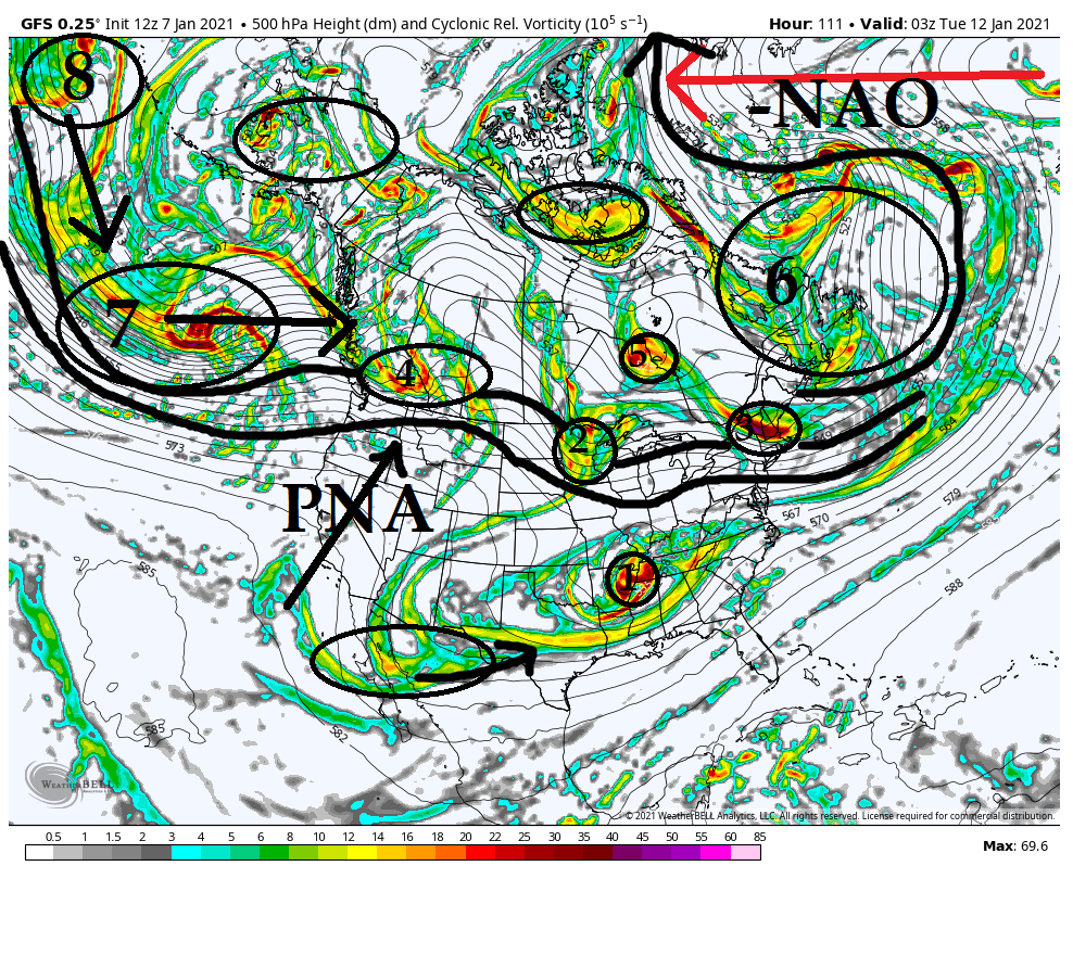
You can see the -NAO ridge is causing a major bottle neck of the energy (#6) in the N Atlantic. This is a good thing in general but Ive said it before sometimes too much of as good thing is a bad thing. In this case can lead to supressed strom tracks. ESP hen the Pac isnt cooperating which is the case in this image.
Look west. Wave after wave of energy is traversing the N Pac and crashing the west coast (8 to 7 to 4). The result is a PNA ridge that tries to amplify but consistently gets knowcked down. Timing has to be perfect with 1 and 2 as they approach the EC when you have such strong blocking in the NAO region otherwise the result is a flatened flow across the northern teir of the CONUS preventing N energy (ie: #2) from digging.
Now here is the thing. We often times get storms to come up when the NAO is relaxing. The reason is as it relaxes it allows our system to come up because it doesnt push so hard. We fortunately have the NAO forecast on both Euro and GFS ensembles to go from a -3 deviation to a -1 deviation. Will this be enough of a relaxation to our NE to allow our system to come north "enough" is yet to be determined.
Dont let the specific verbage from Ray confuse you. He is 100% correct in his idea that the chance isnt great given everything I'm showing above and just how many pieces of energy have to coordinate, BUT there is a chance. And its a decent chance IMHO. I believe models will correct as we get towards saturday or so showing a little more digging of #2 and perhaps a little more interaction between #1 and #2. I also think we see energy like #3 change in the modeling to be out of the way a little more. Again is it enough to make it work...odd favor against it at this time IMHO.
- on Thu Jan 07, 2021 1:33 pm
- Search in: Official Weather Talk Thread
- Topic: Long Range Discussion 20(20) (Ha!)
- Replies: 732
- Views: 31909
