
 Search
December 14th, 2013 Updated Snow Map / Observation Thread
Page 2 of 17 •  1, 2, 3 ... 9 ... 17
 ![]()
Re: December 14th, 2013 Updated Snow Map / Observation Thread
![]() by HEATMISER Fri Dec 13, 2013 8:39 pm
by HEATMISER Fri Dec 13, 2013 8:39 pm
HEATMISER- Posts : 62
Join date : 2013-11-22
Re: December 14th, 2013 Updated Snow Map / Observation Thread
![]() by Frank_Wx Fri Dec 13, 2013 8:40 pm
by Frank_Wx Fri Dec 13, 2013 8:40 pm
HEATMISER wrote:How's it looking for the center of long island(centereach)
1-3/2-4 inches of snow then rain
Frank_Wx- Godzilla Seeker

- Posts : 21305
Join date : 2013-01-05 -

Re: December 14th, 2013 Updated Snow Map / Observation Thread
![]() by HEATMISER Fri Dec 13, 2013 8:42 pm
by HEATMISER Fri Dec 13, 2013 8:42 pm
HEATMISER- Posts : 62
Reputation : 0
Join date : 2013-11-22
Re: December 14th, 2013 Updated Snow Map / Observation Thread
![]() by Frank_Wx Fri Dec 13, 2013 8:44 pm
by Frank_Wx Fri Dec 13, 2013 8:44 pm
HEATMISER wrote:Thanks Frank. Hope it's more
No problem and welcome!
_________________
_______________________________________________________________________________________________________
CLICK HERE to view NJ Strong Snowstorm Classifications

Frank_Wx- Godzilla Seeker
- Posts : 21305
Reputation : 328
Join date : 2013-01-05
Age : 31
Location : Jersey City, NJ -
Re: December 14th, 2013 Updated Snow Map / Observation Thread
![]() by essexcountypete Fri Dec 13, 2013 8:58 pm
by essexcountypete Fri Dec 13, 2013 8:58 pm
If folks put their location (or area) in their signature we know where you all are.

essexcountypete- Pro Enthusiast

- Posts : 783
Reputation : 12
Join date : 2013-12-09
Location : Bloomfield, NJ
Re: December 14th, 2013 Updated Snow Map / Observation Thread
![]() by jimv45 Fri Dec 13, 2013 9:00 pm
by jimv45 Fri Dec 13, 2013 9:00 pm
jimv45- Senior Enthusiast

- Posts : 1168
Reputation : 36
Join date : 2013-09-20
Location : Hopewell jct.
Re: December 14th, 2013 Updated Snow Map / Observation Thread
![]() by Frank_Wx Fri Dec 13, 2013 9:20 pm
by Frank_Wx Fri Dec 13, 2013 9:20 pm
_________________
_______________________________________________________________________________________________________
CLICK HERE to view NJ Strong Snowstorm Classifications
Frank_Wx- Godzilla Seeker
- Posts : 21305
Reputation : 328
Join date : 2013-01-05
Age : 31
Location : Jersey City, NJ -
Re: December 14th, 2013 Updated Snow Map / Observation Thread
![]() by Pauledangerously Fri Dec 13, 2013 9:38 pm
by Pauledangerously Fri Dec 13, 2013 9:38 pm

Pauledangerously- Posts : 11
Reputation : 0
Join date : 2013-12-13
Location : Jersey City,NJ
Re: December 14th, 2013 Updated Snow Map / Observation Thread
![]() by Frank_Wx Fri Dec 13, 2013 9:49 pm
by Frank_Wx Fri Dec 13, 2013 9:49 pm
Pauledangerously wrote:Good looks Franky! I was a lurker on the 7boards and I like your layman's terms when it comes to weather. Sorry I don't know too much about the weather nor do I have a desire to learn(no offence). But the info you put out is nice.
Thank Paul! Thanks for following
_________________
_______________________________________________________________________________________________________
CLICK HERE to view NJ Strong Snowstorm Classifications
Frank_Wx- Godzilla Seeker
- Posts : 21305
Reputation : 328
Join date : 2013-01-05
Age : 31
Location : Jersey City, NJ -
Re: December 14th, 2013 Updated Snow Map / Observation Thread
![]() by Frank_Wx Fri Dec 13, 2013 10:37 pm
by Frank_Wx Fri Dec 13, 2013 10:37 pm

RGEM shows bad icing in central NJ. Wow
_________________
_______________________________________________________________________________________________________
CLICK HERE to view NJ Strong Snowstorm Classifications
Frank_Wx- Godzilla Seeker
- Posts : 21305
Reputation : 328
Join date : 2013-01-05
Age : 31
Location : Jersey City, NJ -
Re: December 14th, 2013 Updated Snow Map / Observation Thread
![]() by Noreaster Fri Dec 13, 2013 10:39 pm
by Noreaster Fri Dec 13, 2013 10:39 pm

Noreaster- Posts : 463
Reputation : 5
Join date : 2013-01-08
Age : 41
Location : Merrick, NY
Re: December 14th, 2013 Updated Snow Map / Observation Thread
![]() by Noreaster Fri Dec 13, 2013 10:40 pm
by Noreaster Fri Dec 13, 2013 10:40 pm
Noreaster- Posts : 463
Reputation : 5
Join date : 2013-01-08
Age : 41
Location : Merrick, NY
Re: December 14th, 2013 Updated Snow Map / Observation Thread
![]() by Frank_Wx Fri Dec 13, 2013 10:44 pm
by Frank_Wx Fri Dec 13, 2013 10:44 pm
_________________
_______________________________________________________________________________________________________
CLICK HERE to view NJ Strong Snowstorm Classifications
Frank_Wx- Godzilla Seeker
- Posts : 21305
Reputation : 328
Join date : 2013-01-05
Age : 31
Location : Jersey City, NJ -
Re: December 14th, 2013 Updated Snow Map / Observation Thread
![]() by Noreaster Fri Dec 13, 2013 10:45 pm
by Noreaster Fri Dec 13, 2013 10:45 pm
Noreaster- Posts : 463
Reputation : 5
Join date : 2013-01-08
Age : 41
Location : Merrick, NY
Re: December 14th, 2013 Updated Snow Map / Observation Thread
![]() by jmanley32 Fri Dec 13, 2013 10:49 pm
by jmanley32 Fri Dec 13, 2013 10:49 pm

jmanley32- Senior Enthusiast
- Posts : 20516
Reputation : 108
Join date : 2013-12-12
Age : 42
Location : Yonkers, NY
Re: December 14th, 2013 Updated Snow Map / Observation Thread
![]() by jbnyy224 Fri Dec 13, 2013 10:56 pm
by jbnyy224 Fri Dec 13, 2013 10:56 pm
jbnyy224- Posts : 83
Reputation : 0
Join date : 2013-01-11
Age : 38
Location : Brooklyn, NY
Re: December 14th, 2013 Updated Snow Map / Observation Thread
![]() by Noreaster Fri Dec 13, 2013 11:31 pm
by Noreaster Fri Dec 13, 2013 11:31 pm
Noreaster- Posts : 463
Reputation : 5
Join date : 2013-01-08
Age : 41
Location : Merrick, NY
Re: December 14th, 2013 Updated Snow Map / Observation Thread
![]() by CPcantmeasuresnow Fri Dec 13, 2013 11:42 pm
by CPcantmeasuresnow Fri Dec 13, 2013 11:42 pm

CPcantmeasuresnow- Wx Statistician Guru

- Posts : 7274
Reputation : 230
Join date : 2013-01-07
Age : 103
Location : Eastern Orange County, NY
Re: December 14th, 2013 Updated Snow Map / Observation Thread
![]() by Math23x7 Sat Dec 14, 2013 12:21 am
by Math23x7 Sat Dec 14, 2013 12:21 am
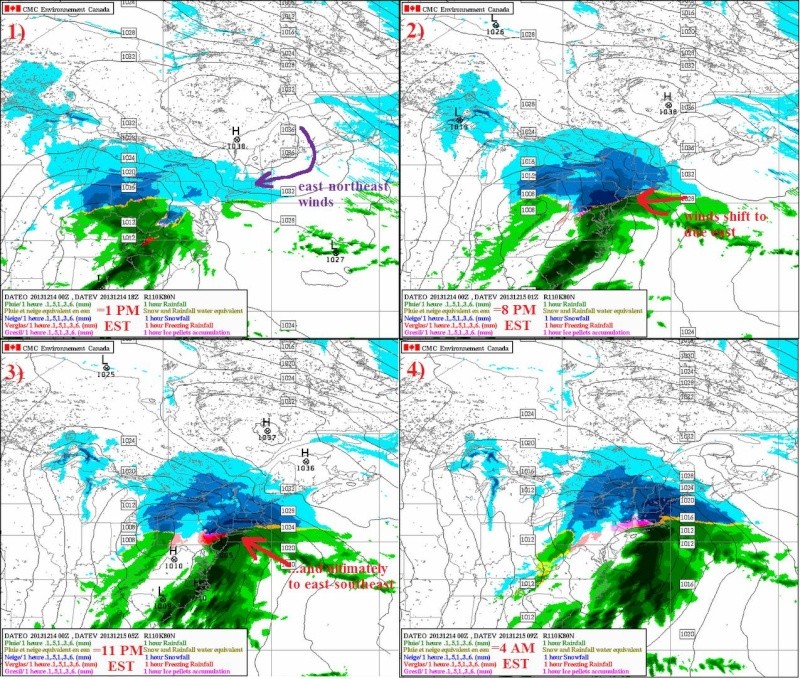
1) upper left: By the early afternoon, snow is making it's way into the NYC region. It will be in the upper 20s around this time in the city but in the upper teens in the northwest suburbs (i.e. Orange/Putnam counties)
2) upper right: By the early evening, the snow will really begin to accumulate across the area. But alas, the winds begin to shift in NYC and the rain-snow line is creeping northward as temperatures warm.
3) lower left: Later in the evening, the transition to rain is pretty much complete for southern New Jersey, NYC, and Long Island. Temperatures for these regions will be in the mid to upper 30s around this time. But the further north you go, the longer it takes to changeover to rain. In fact, some locations where it does not go above 32 degrees Fahrenheit will see an ICE storm, in which a quarter of an inch of ICE is possible!
4) lower-right: By early morning Sunday, the precipitation is tapering off in the NYC region but still hangs on to the north and east.
The last two images both shows the pink/red on precip map which indicate ICE. To me Ice could be an issue, especially for the roadways for the following: interior Central/Northern NJ, northern Westchester county, Rockland County, Orange County, Putnam County, Dutchess County, and most if not all of Connecticut)
The model shows 3-6 inches of snow for NYC with higher amounts north and west and lower amounts south and east. Personally, my gut tells me ~3" of snow for eastern Queens, NY (where I live), and ~4.5" for Central Park, NY before the changeover. The next 30-36 hours sure will be interesting to watch!
Math23x7- Wx Statistician Guru
- Posts : 2379
Reputation : 68
Join date : 2013-01-08
Re: December 14th, 2013 Updated Snow Map / Observation Thread
![]() by 2004blackwrx Sat Dec 14, 2013 4:49 am
by 2004blackwrx Sat Dec 14, 2013 4:49 am
2004blackwrx- Pro Enthusiast
- Posts : 576
Reputation : 9
Join date : 2013-01-14
Location : Wappinger NY
Re: December 14th, 2013 Updated Snow Map / Observation Thread
![]() by Noreaster Sat Dec 14, 2013 5:08 am
by Noreaster Sat Dec 14, 2013 5:08 am
Noreaster- Posts : 463
Reputation : 5
Join date : 2013-01-08
Age : 41
Location : Merrick, NY
Re: December 14th, 2013 Updated Snow Map / Observation Thread
![]() by CPcantmeasuresnow Sat Dec 14, 2013 6:17 am
by CPcantmeasuresnow Sat Dec 14, 2013 6:17 am
CPcantmeasuresnow- Wx Statistician Guru
- Posts : 7274
Reputation : 230
Join date : 2013-01-07
Age : 103
Location : Eastern Orange County, NY
Re: December 14th, 2013 Updated Snow Map / Observation Thread
![]() by SNOW MAN Sat Dec 14, 2013 6:21 am
by SNOW MAN Sat Dec 14, 2013 6:21 am

SNOW MAN- Senior Enthusiast
- Posts : 1361
Reputation : 25
Join date : 2013-01-13
Age : 64
Location : Marshalls Creek Pa.
Re: December 14th, 2013 Updated Snow Map / Observation Thread
![]() by sroc4 Sat Dec 14, 2013 6:51 am
by sroc4 Sat Dec 14, 2013 6:51 am
_________________
"In weather and in life, there's no winning and losing; there's only winning and learning."
WINTER 2012/2013 TOTALS 43.65"WINTER 2017/2018 TOTALS 62.85" WINTER 2022/2023 TOTALS 4.9"
WINTER 2013/2014 TOTALS 64.85"WINTER 2018/2019 TOTALS 14.25" WINTER 2023/2024 TOTALS 13.1"
WINTER 2014/2015 TOTALS 71.20"WINTER 2019/2020 TOTALS 6.35"
WINTER 2015/2016 TOTALS 35.00"WINTER 2020/2021 TOTALS 37.75"
WINTER 2016/2017 TOTALS 42.25"WINTER 2021/2022 TOTALS 31.65"

sroc4- Admin
- Posts : 8331
Reputation : 301
Join date : 2013-01-07
Location : Wading River, LI
Re: December 14th, 2013 Updated Snow Map / Observation Thread
![]() by docstox12 Sat Dec 14, 2013 6:57 am
by docstox12 Sat Dec 14, 2013 6:57 am

docstox12- Wx Statistician Guru
- Posts : 8505
Reputation : 222
Join date : 2013-01-07
Age : 73
Location : Monroe NY
Re: December 14th, 2013 Updated Snow Map / Observation Thread
![]() by Scullybutcher Sat Dec 14, 2013 6:58 am
by Scullybutcher Sat Dec 14, 2013 6:58 am

Scullybutcher- Pro Enthusiast
- Posts : 543
Reputation : 16
Join date : 2013-02-06
Location : North Smithtown, western Suffolk county, long island
Re: December 14th, 2013 Updated Snow Map / Observation Thread
![]() by CPcantmeasuresnow Sat Dec 14, 2013 7:06 am
by CPcantmeasuresnow Sat Dec 14, 2013 7:06 am
CPcantmeasuresnow- Wx Statistician Guru
- Posts : 7274
Reputation : 230
Join date : 2013-01-07
Age : 103
Location : Eastern Orange County, NY
Sponsored content
Page 2 of 17 • 1, 2, 3 ... 9 ... 17 ![]()
|
|
|