
 Search
January 2nd-3rd Potential Snowstorm
Page 1 of 23 • 1, 2, 3 ... 12 ... 23 ![]()

January 2nd-3rd Potential Snowstorm
![]() by Frank_Wx Sat Dec 28, 2013 10:39 am
by Frank_Wx Sat Dec 28, 2013 10:39 am
A piece of energy ejecting out of Canada has an opportunity to phase with another piece of energy in the southeast. If the two come together, it could produce a big storm.

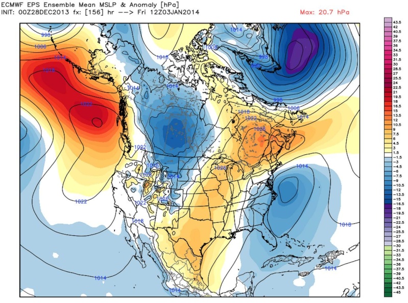
The euro 500 mb map above shows a nice ridge in the west (+PNA) which helps the northern stream energy dig into the trough.
The problem is, there is a kicker to its north that is flattening the ridge as you can see below also from the EURO.

If the ridge flattens, both pieces of energy will not phase and we may just see some high ratio snowfall from the northern stream energy. We want the ridge axis to stay as far west as possible (not toward the Midwest like euro shows).

Above you see the euro is close to a big storm, but kicks the southern steam energy ahead of the northern stream energy. There is also a strong confluence to our north thanks to the polar vortex which prevents snow from getting to a certain latitude.

GFS looks drastically different. THe confluence to the north is not as strong a coastal does develop. If the phase was 6 hours sooner, it would be a big storm.
So...
1. Need the PNA ridge to stay amplified, not flatten out
2. Need the PNA ridge to stay west, not shift east into the Midwest
3. Need the confluence to our north to remain weak to allow moisture to get to our latitude
4. Need a phase with both polar and sub tropical jets, or else this would be a weak snow event (fine with me)
This time frame is not the only one to watch either. The 5th-10th offers more potential as well.
_________________
_______________________________________________________________________________________________________
CLICK HERE to view NJ Strong Snowstorm Classifications

Frank_Wx- Godzilla Seeker

- Posts : 21305
Reputation : 328
Join date : 2013-01-05
Age : 31
Location : Jersey City, NJ -

Re: January 2nd-3rd Potential Snowstorm
![]() by Math23x7 Sat Dec 28, 2013 11:02 am
by Math23x7 Sat Dec 28, 2013 11:02 am
The mean shows a low pressure system off the coast but doesn't look that impressive.
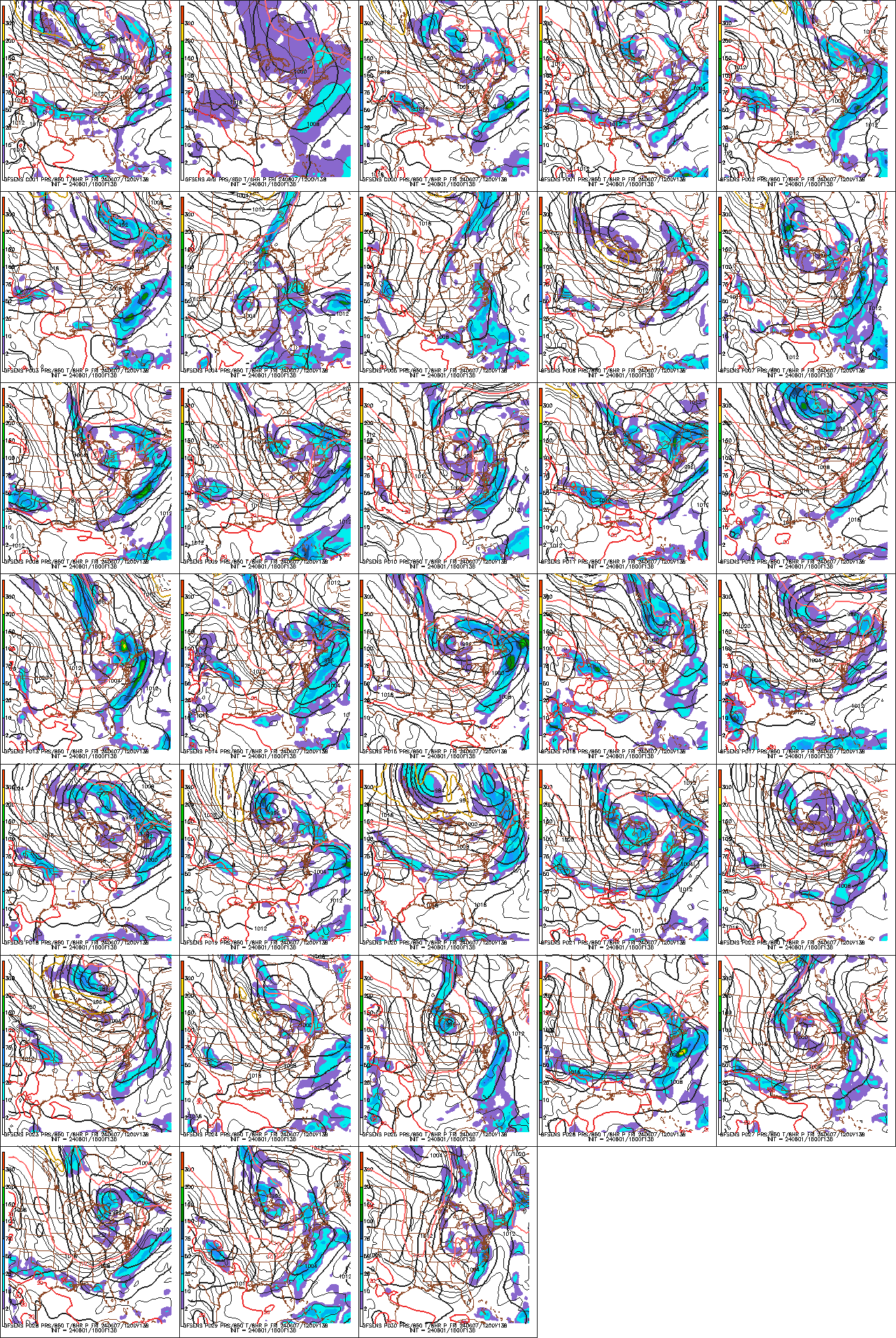
Meanwhile, the snow totals for the 51 members of the ensemble are looking more impressive. On the right hand side of the image below, I put a green dot next to the members that give Central Park, NY at least 6 inches of snow and a red dot next to those with less than 6 inches:
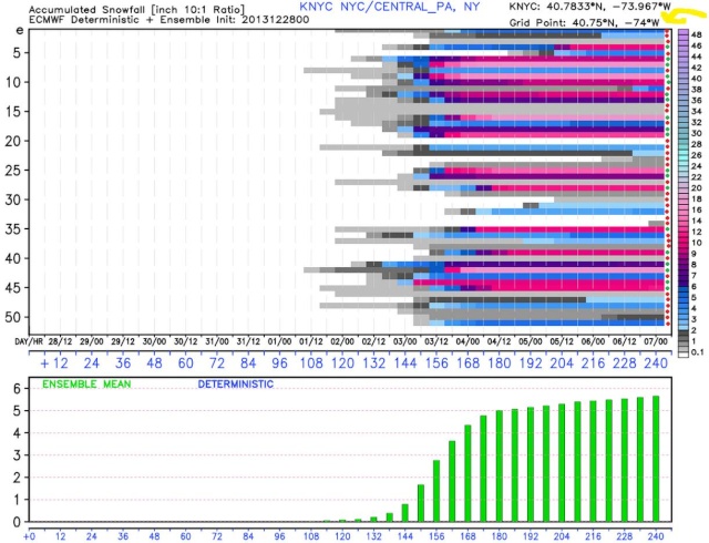
19 of the members show at least 6 inches of snow (assuming of course the 10:1 ratio verifies). Meanwhile, the Ensemble mean has over 5 inches of snow on this run. Should be an interesting next few days to track this system...
Math23x7- Wx Statistician Guru

- Posts : 2379
Reputation : 68
Join date : 2013-01-08
Re: January 2nd-3rd Potential Snowstorm
![]() by amugs Sat Dec 28, 2013 11:11 am
by amugs Sat Dec 28, 2013 11:11 am
Looks good to me but I would prefer a GFS solution at this point and that dam PNA spike better not flatten out or move past Idaho!!
If I recall correctly this has a similar NEMO set up from 2-8-13??
Watch how this board explodes over the next couple of days
_________________
Mugs
AKA:King: Snow Weenie
Self Proclaimed
WINTER 2014-15 : 55.12" +.02 for 6 coatings (avg. 35")
WINTER 2015-16 Total - 29.8" (Avg 35")
WINTER 2016-17 : 39.5" so far

amugs- Advanced Forecaster - Mod

- Posts : 15093
Reputation : 213
Join date : 2013-01-07
Age : 54
Location : Hillsdale,NJ
Re: January 2nd-3rd Potential Snowstorm
![]() by Frank_Wx Sat Dec 28, 2013 11:16 am
by Frank_Wx Sat Dec 28, 2013 11:16 am
_________________
_______________________________________________________________________________________________________
CLICK HERE to view NJ Strong Snowstorm Classifications
Frank_Wx- Godzilla Seeker
- Posts : 21305
Reputation : 328
Join date : 2013-01-05
Age : 31
Location : Jersey City, NJ -
Re: January 2nd-3rd Potential Snowstorm
![]() by Frank_Wx Sat Dec 28, 2013 11:23 am
by Frank_Wx Sat Dec 28, 2013 11:23 am


_________________
_______________________________________________________________________________________________________
CLICK HERE to view NJ Strong Snowstorm Classifications
Frank_Wx- Godzilla Seeker
- Posts : 21305
Reputation : 328
Join date : 2013-01-05
Age : 31
Location : Jersey City, NJ -
Re: January 2nd-3rd Potential Snowstorm
![]() by Quietace Sat Dec 28, 2013 11:46 am
by Quietace Sat Dec 28, 2013 11:46 am

Quietace- Meteorologist - Mod

- Posts : 3687
Reputation : 33
Join date : 2013-01-07
Age : 27
Location : Point Pleasant, NJ
Re: January 2nd-3rd Potential Snowstorm
![]() by Frank_Wx Sat Dec 28, 2013 11:54 am
by Frank_Wx Sat Dec 28, 2013 11:54 am
_________________
_______________________________________________________________________________________________________
CLICK HERE to view NJ Strong Snowstorm Classifications
Frank_Wx- Godzilla Seeker
- Posts : 21305
Reputation : 328
Join date : 2013-01-05
Age : 31
Location : Jersey City, NJ -
Re: January 2nd-3rd Potential Snowstorm
![]() by Frank_Wx Sat Dec 28, 2013 12:13 pm
by Frank_Wx Sat Dec 28, 2013 12:13 pm
_________________
_______________________________________________________________________________________________________
CLICK HERE to view NJ Strong Snowstorm Classifications
Frank_Wx- Godzilla Seeker
- Posts : 21305
Reputation : 328
Join date : 2013-01-05
Age : 31
Location : Jersey City, NJ -
Re: January 2nd-3rd Potential Snowstorm
![]() by Frank_Wx Sat Dec 28, 2013 1:28 pm
by Frank_Wx Sat Dec 28, 2013 1:28 pm
http://usa-wx.com/uploads/monthly_12_2013/post-40-0-20731100-1388255196.jpg
_________________
_______________________________________________________________________________________________________
CLICK HERE to view NJ Strong Snowstorm Classifications
Frank_Wx- Godzilla Seeker
- Posts : 21305
Reputation : 328
Join date : 2013-01-05
Age : 31
Location : Jersey City, NJ -
Re: January 2nd-3rd Potential Snowstorm
![]() by Frank_Wx Sat Dec 28, 2013 1:29 pm
by Frank_Wx Sat Dec 28, 2013 1:29 pm
_________________
_______________________________________________________________________________________________________
CLICK HERE to view NJ Strong Snowstorm Classifications
Frank_Wx- Godzilla Seeker
- Posts : 21305
Reputation : 328
Join date : 2013-01-05
Age : 31
Location : Jersey City, NJ -
Re: January 2nd-3rd Potential Snowstorm
![]() by Frank_Wx Sat Dec 28, 2013 1:39 pm
by Frank_Wx Sat Dec 28, 2013 1:39 pm

_________________
_______________________________________________________________________________________________________
CLICK HERE to view NJ Strong Snowstorm Classifications
Frank_Wx- Godzilla Seeker
- Posts : 21305
Reputation : 328
Join date : 2013-01-05
Age : 31
Location : Jersey City, NJ -
Re: January 2nd-3rd Potential Snowstorm
![]() by jmanley32 Sat Dec 28, 2013 2:14 pm
by jmanley32 Sat Dec 28, 2013 2:14 pm

jmanley32- Senior Enthusiast

- Posts : 20516
Reputation : 108
Join date : 2013-12-12
Age : 42
Location : Yonkers, NY
Re: January 2nd-3rd Potential Snowstorm
![]() by amugs Sat Dec 28, 2013 5:43 pm
by amugs Sat Dec 28, 2013 5:43 pm
12Z MODELS ARE COMING INTO BETTER AGREEMENT REGARDING THE POTENTIAL
OF A COASTAL STORM AFFECTING US THURSDAY INTO FRIDAY. ALTHOUGH FULL
PHASING OF NORTHERN AND SOUTHERN STREAMS ARE STILL FORECAST TO OCCUR
TO OUR EAST...A SHARPENING LONGWAVE TROUGH STARTS TO BECOME
NEGATIVELY TILTED AS ITS AXIS IS NEAR US. THIS WILL HELP STRENGTHEN
LOW PRESSURE EMERGING OFF THE MID-ATLANTIC COAST SOMETIME LATE
THURSDAY/THURSDAY NIGHT. MODELS HAVE THE CENTER OF THIS STORM
EVENTUALLY PASSING NEAR THE 40N/70W BENCHMARK LATE THURSDAY NIGHT
BEFORE HEADING FARTHER NE ON FRIDAY. WITH HIGH PRESSURE OVER THE
VICINITY OF NORTHERN NEW ENGLAND...ANTECEDENT COLD AIR WOULD HAVE
ANY PRECIP BEGIN AS SNOW...AND DEPENDING ON THE EVENTUAL TRACK OF
THE STORM...THIS HAS THE POTENTIAL TO BE AN ALL-SNOW EVENT. BEST
CHANCES FOR ANY MIXING AS USUAL WILL BE OVER SE SECTIONS OF THE CWA.
NOT ENOUGH CONFIDENCE AT THIS TIME IN THE TIMING/TRACK/STRENGTH OF
THE STORM FOR A MENTION IN THE HWO. WOULD FIRST LIKE TO SEE SOME
RUN-TO-RUN CONSISTENCY FOR EACH MODEL AS WELL AS CONSISTENCY AMONG
THE DIFFERENT MODELS. ADDING TO THE UNCERTAINTY IS THAT BOTH THE 12Z
ENSEMBLE MEAN FOR THE ECMWF...AND NOT SURPRISINGLY FOR THE GFS...ARE
FARTHER SOUTHEAST WITH THE TRACK OF THE STORM. HIGH PRESSURE WOULD
THEN BUILD BEHIND THE DEPARTING STORM FRIDAY NIGHT AND SATURDAY WITH
DRY WEATHER AND BELOW-NORMAL TEMPERATURES.
Hey Upton - wouldn't we all like to see model run consistency?!
BTW aren't we going to have below normal temps after this Nor'easter Sunday??
_________________
Mugs
AKA:King: Snow Weenie
Self Proclaimed
WINTER 2014-15 : 55.12" +.02 for 6 coatings (avg. 35")
WINTER 2015-16 Total - 29.8" (Avg 35")
WINTER 2016-17 : 39.5" so far
amugs- Advanced Forecaster - Mod
- Posts : 15093
Reputation : 213
Join date : 2013-01-07
Age : 54
Location : Hillsdale,NJ
Re: January 2nd-3rd Potential Snowstorm
![]() by Quietace Sat Dec 28, 2013 5:54 pm
by Quietace Sat Dec 28, 2013 5:54 pm
One more thing,
We have to remember that the pieces of this system are not onshore yet, and that models will have closer solutions(hopefully) once we can get better sampling.
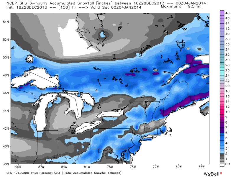
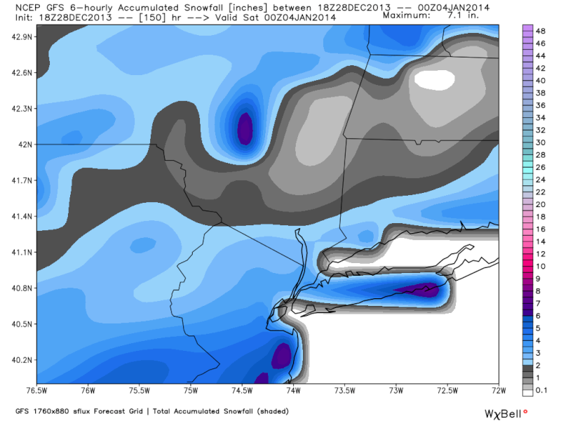
18 GFS snow map
Quietace- Meteorologist - Mod
- Posts : 3687
Reputation : 33
Join date : 2013-01-07
Age : 27
Location : Point Pleasant, NJ
Re: January 2nd-3rd Potential Snowstorm
![]() by amugs Sat Dec 28, 2013 6:24 pm
by amugs Sat Dec 28, 2013 6:24 pm
_________________
Mugs
AKA:King: Snow Weenie
Self Proclaimed
WINTER 2014-15 : 55.12" +.02 for 6 coatings (avg. 35")
WINTER 2015-16 Total - 29.8" (Avg 35")
WINTER 2016-17 : 39.5" so far
amugs- Advanced Forecaster - Mod
- Posts : 15093
Reputation : 213
Join date : 2013-01-07
Age : 54
Location : Hillsdale,NJ
Re: January 2nd-3rd Potential Snowstorm
![]() by jmanley32 Sat Dec 28, 2013 6:41 pm
by jmanley32 Sat Dec 28, 2013 6:41 pm
jmanley32- Senior Enthusiast
- Posts : 20516
Reputation : 108
Join date : 2013-12-12
Age : 42
Location : Yonkers, NY
Re: January 2nd-3rd Potential Snowstorm
![]() by Frank_Wx Sat Dec 28, 2013 11:42 pm
by Frank_Wx Sat Dec 28, 2013 11:42 pm

You can tell from the above image just how much the EURO gets the STJ involved in this storm. It's important because we do not have to rely on much phasing from the PV and the trough goes positively tilted.
Tonight's 00z GFS still looks pretty much like previous runs. No STJ interaction, kicker in the Pac NW causing the ridge to roll over and pretty much force an overrunning event with the northern stream energy.
Eventually, something's gotta give.
_________________
_______________________________________________________________________________________________________
CLICK HERE to view NJ Strong Snowstorm Classifications
Frank_Wx- Godzilla Seeker
- Posts : 21305
Reputation : 328
Join date : 2013-01-05
Age : 31
Location : Jersey City, NJ -
Re: January 2nd-3rd Potential Snowstorm
![]() by Frank_Wx Sat Dec 28, 2013 11:57 pm
by Frank_Wx Sat Dec 28, 2013 11:57 pm
00z NAVGEM...

_________________
_______________________________________________________________________________________________________
CLICK HERE to view NJ Strong Snowstorm Classifications
Frank_Wx- Godzilla Seeker
- Posts : 21305
Reputation : 328
Join date : 2013-01-05
Age : 31
Location : Jersey City, NJ -
Re: January 2nd-3rd Potential Snowstorm
![]() by oldtimer Sun Dec 29, 2013 12:01 am
by oldtimer Sun Dec 29, 2013 12:01 am
oldtimer- Senior Enthusiast
- Posts : 1103
Reputation : 14
Join date : 2013-01-16
Age : 78
Location : Port Jefferson Station Suffolk County
Re: January 2nd-3rd Potential Snowstorm
![]() by Frank_Wx Sun Dec 29, 2013 7:54 am
by Frank_Wx Sun Dec 29, 2013 7:54 am

_________________
_______________________________________________________________________________________________________
CLICK HERE to view NJ Strong Snowstorm Classifications
Frank_Wx- Godzilla Seeker
- Posts : 21305
Reputation : 328
Join date : 2013-01-05
Age : 31
Location : Jersey City, NJ -
Re: January 2nd-3rd Potential Snowstorm
![]() by skinsfan1177 Sun Dec 29, 2013 8:13 am
by skinsfan1177 Sun Dec 29, 2013 8:13 am

skinsfan1177- Senior Enthusiast
- Posts : 4485
Reputation : 35
Join date : 2013-01-07
Age : 46
Location : Point Pleasant Boro
Re: January 2nd-3rd Potential Snowstorm
![]() by sroc4 Sun Dec 29, 2013 8:25 am
by sroc4 Sun Dec 29, 2013 8:25 am
_________________
"In weather and in life, there's no winning and losing; there's only winning and learning."
WINTER 2012/2013 TOTALS 43.65"WINTER 2017/2018 TOTALS 62.85" WINTER 2022/2023 TOTALS 4.9"
WINTER 2013/2014 TOTALS 64.85"WINTER 2018/2019 TOTALS 14.25" WINTER 2023/2024 TOTALS 13.1"
WINTER 2014/2015 TOTALS 71.20"WINTER 2019/2020 TOTALS 6.35"
WINTER 2015/2016 TOTALS 35.00"WINTER 2020/2021 TOTALS 37.75"
WINTER 2016/2017 TOTALS 42.25"WINTER 2021/2022 TOTALS 31.65"

sroc4- Admin
- Posts : 8331
Reputation : 301
Join date : 2013-01-07
Location : Wading River, LI
Re: January 2nd-3rd Potential Snowstorm
![]() by sroc4 Sun Dec 29, 2013 8:29 am
by sroc4 Sun Dec 29, 2013 8:29 am
_________________
"In weather and in life, there's no winning and losing; there's only winning and learning."
WINTER 2012/2013 TOTALS 43.65"WINTER 2017/2018 TOTALS 62.85" WINTER 2022/2023 TOTALS 4.9"
WINTER 2013/2014 TOTALS 64.85"WINTER 2018/2019 TOTALS 14.25" WINTER 2023/2024 TOTALS 13.1"
WINTER 2014/2015 TOTALS 71.20"WINTER 2019/2020 TOTALS 6.35"
WINTER 2015/2016 TOTALS 35.00"WINTER 2020/2021 TOTALS 37.75"
WINTER 2016/2017 TOTALS 42.25"WINTER 2021/2022 TOTALS 31.65"
sroc4- Admin
- Posts : 8331
Reputation : 301
Join date : 2013-01-07
Location : Wading River, LI
Re: January 2nd-3rd Potential Snowstorm
![]() by skinsfan1177 Sun Dec 29, 2013 9:01 am
by skinsfan1177 Sun Dec 29, 2013 9:01 am
skinsfan1177- Senior Enthusiast
- Posts : 4485
Reputation : 35
Join date : 2013-01-07
Age : 46
Location : Point Pleasant Boro
Re: January 2nd-3rd Potential Snowstorm
![]() by CPcantmeasuresnow Sun Dec 29, 2013 9:02 am
by CPcantmeasuresnow Sun Dec 29, 2013 9:02 am
sroc4 wrote:I still feel like with the established pattern this year the track ends up inside the BM and the coastal plain battles the R/S regardless.
I agree wholeheartedly.
Some winters the timing between the cold air and the storms is just perfect every time, 93-94, 95-96, 09-10, 10-11.
others are awful and the timing is never right 97-98, 01-02, 11-12.
So far this winter cant seem to decide one way or the other. Looking ahead I don't see this changing.

CPcantmeasuresnow- Wx Statistician Guru
- Posts : 7274
Reputation : 230
Join date : 2013-01-07
Age : 103
Location : Eastern Orange County, NY
Page 1 of 23 • 1, 2, 3 ... 12 ... 23 ![]()
|
|
|