
 Search
January 2nd-3rd Potential Snowstorm
Page 23 of 23 •  1 ... 13 ... 21, 22, 23
Re: January 2nd-3rd Potential Snowstorm
![]() by jmanley32 Tue Dec 31, 2013 1:42 pm
by jmanley32 Tue Dec 31, 2013 1:42 pm
jmanley32- Senior Enthusiast

- Posts : 20516
Join date : 2013-12-12
Re: January 2nd-3rd Potential Snowstorm
![]() by RJB8525 Tue Dec 31, 2013 1:52 pm
by RJB8525 Tue Dec 31, 2013 1:52 pm
I have been a meteorologist for more than 18 years. There is a reason meteorologists don't go throwing numbers out so far in advance because things can change. A unwritten rule at news12 is we usually post snow fall totals 24-36 hours in advance, no hype just straight forward. Looking at the 12z data I noticed more of a southeast trend. If that trend continues we could see light snowfall amounts. I want to thank all the people who follow me on facebook and watched me for more than 11 years on news12 LI.
RJB8525- Senior Enthusiast
- Posts : 1994
Join date : 2013-02-06
Re: January 2nd-3rd Potential Snowstorm
![]() by docstox12 Tue Dec 31, 2013 1:56 pm
by docstox12 Tue Dec 31, 2013 1:56 pm

docstox12- Wx Statistician Guru

- Posts : 8504
Reputation : 222
Join date : 2013-01-07
Age : 73
Location : Monroe NY
Re: January 2nd-3rd Potential Snowstorm
![]() by skinsfan1177 Tue Dec 31, 2013 1:57 pm
by skinsfan1177 Tue Dec 31, 2013 1:57 pm

skinsfan1177- Senior Enthusiast
- Posts : 4485
Reputation : 35
Join date : 2013-01-07
Age : 46
Location : Point Pleasant Boro
Re: January 2nd-3rd Potential Snowstorm
![]() by CPcantmeasuresnow Tue Dec 31, 2013 1:57 pm
by CPcantmeasuresnow Tue Dec 31, 2013 1:57 pm
RJB8525 wrote:From News12 LI Rich Hoffman:
I have been a meteorologist for more than 18 years. There is a reason meteorologists don't go throwing numbers out so far in advance because things can change. A unwritten rule at news12 is we usually post snow fall totals 24-36 hours in advance, no hype just straight forward. Looking at the 12z data I noticed more of a southeast trend. If that trend continues we could see light snowfall amounts. I want to thank all the people who follow me on facebook and watched me for more than 11 years on news12 LI.
We do need a trend in the other direction soon because the last 24 hours, after yesterdays euphoria has been all downhill.

CPcantmeasuresnow- Wx Statistician Guru
- Posts : 7274
Reputation : 230
Join date : 2013-01-07
Age : 103
Location : Eastern Orange County, NY
Re: January 2nd-3rd Potential Snowstorm
![]() by CPcantmeasuresnow Tue Dec 31, 2013 1:59 pm
by CPcantmeasuresnow Tue Dec 31, 2013 1:59 pm
CPcantmeasuresnow- Wx Statistician Guru
- Posts : 7274
Reputation : 230
Join date : 2013-01-07
Age : 103
Location : Eastern Orange County, NY
Re: January 2nd-3rd Potential Snowstorm
![]() by docstox12 Tue Dec 31, 2013 1:59 pm
by docstox12 Tue Dec 31, 2013 1:59 pm
docstox12- Wx Statistician Guru
- Posts : 8504
Reputation : 222
Join date : 2013-01-07
Age : 73
Location : Monroe NY
Re: January 2nd-3rd Potential Snowstorm
![]() by CPcantmeasuresnow Tue Dec 31, 2013 2:01 pm
by CPcantmeasuresnow Tue Dec 31, 2013 2:01 pm
docstox12 wrote:Yet, NWS is calling for 5 to 9 and Accuweather says 6-12 in my area.I think someone says Evans called for 6-12 north of the City.That's three services pretty much in line even with the trend fading.
Doc:
I think NWS updates again at 4 o'clock. Pretty sure we'll see lower amounts then.
CPcantmeasuresnow- Wx Statistician Guru
- Posts : 7274
Reputation : 230
Join date : 2013-01-07
Age : 103
Location : Eastern Orange County, NY
Re: January 2nd-3rd Potential Snowstorm
![]() by Dunnzoo Tue Dec 31, 2013 2:05 pm
by Dunnzoo Tue Dec 31, 2013 2:05 pm
CPcantmeasuresnow wrote:BTW- how and where do i post my seasonal snowfall totals?
CP, go to your profile and then in the signature tab you can type what you want....if we can get everyone else on that we will have a good idea who gets what where throughout the season....
_________________
Janet
Snowfall winter of 2023-2024 17.5"
Snowfall winter of 2022-2023 6.0"
Snowfall winter of 2021-2022 17.6" 1" sleet 2/25/22
Snowfall winter of 2020-2021 51.1"
Snowfall winter of 2019-2020 8.5"
Snowfall winter of 2018-2019 25.1"
Snowfall winter of 2017-2018 51.9"
Snowfall winter of 2016-2017 45.6"
Snowfall winter of 2015-2016 29.5"
Snowfall winter of 2014-2015 50.55"
Snowfall winter of 2013-2014 66.5"

Dunnzoo- Senior Enthusiast - Mod

- Posts : 4891
Reputation : 68
Join date : 2013-01-11
Age : 62
Location : Westwood, NJ
Re: January 2nd-3rd Potential Snowstorm
![]() by SoulSingMG Tue Dec 31, 2013 2:05 pm
by SoulSingMG Tue Dec 31, 2013 2:05 pm
We just cannot get 'our' storm, can we.

SoulSingMG- Senior Enthusiast
- Posts : 2853
Reputation : 74
Join date : 2013-12-11
Location : Long Island City, NY
Re: January 2nd-3rd Potential Snowstorm
![]() by docstox12 Tue Dec 31, 2013 2:06 pm
by docstox12 Tue Dec 31, 2013 2:06 pm
BTW, read HM and he says Monday is a GLC for us with rain.
docstox12- Wx Statistician Guru
- Posts : 8504
Reputation : 222
Join date : 2013-01-07
Age : 73
Location : Monroe NY
Re: January 2nd-3rd Potential Snowstorm
![]() by CPcantmeasuresnow Tue Dec 31, 2013 2:07 pm
by CPcantmeasuresnow Tue Dec 31, 2013 2:07 pm
Dunnzoo wrote:CPcantmeasuresnow wrote:BTW- how and where do i post my seasonal snowfall totals?
CP, go to your profile and then in the signature tab you can type what you want....if we can get everyone else on that we will have a good idea who gets what where throughout the season....
Thanks Janet.
CPcantmeasuresnow- Wx Statistician Guru
- Posts : 7274
Reputation : 230
Join date : 2013-01-07
Age : 103
Location : Eastern Orange County, NY
Re: January 2nd-3rd Potential Snowstorm
![]() by Frank_Wx Tue Dec 31, 2013 2:08 pm
by Frank_Wx Tue Dec 31, 2013 2:08 pm
_________________
_______________________________________________________________________________________________________
CLICK HERE to view NJ Strong Snowstorm Classifications

Frank_Wx- Godzilla Seeker

- Posts : 21305
Reputation : 328
Join date : 2013-01-05
Age : 31
Location : Jersey City, NJ -

Re: January 2nd-3rd Potential Snowstorm
![]() by docstox12 Tue Dec 31, 2013 2:08 pm
by docstox12 Tue Dec 31, 2013 2:08 pm
SoulSingMG wrote:What a disappointing 12 hours of model runs.
We just cannot get 'our' storm, can we.
Plenty of winter left for that.It's that friggin' NAO that is hanging us up.Great cold air, active storm pattern but we can't get a big snowstorm to come together.Maybe a few more weeks the pattern will become more favorable for that.
docstox12- Wx Statistician Guru
- Posts : 8504
Reputation : 222
Join date : 2013-01-07
Age : 73
Location : Monroe NY
Re: January 2nd-3rd Potential Snowstorm
![]() by Frank_Wx Tue Dec 31, 2013 2:14 pm
by Frank_Wx Tue Dec 31, 2013 2:14 pm
docstox12 wrote:SoulSingMG wrote:What a disappointing 12 hours of model runs.
We just cannot get 'our' storm, can we.
Plenty of winter left for that.It's that friggin' NAO that is hanging us up.Great cold air, active storm pattern but we can't get a big snowstorm to come together.Maybe a few more weeks the pattern will become more favorable for that.
Exactly. People should not be upset with this storm regardless of final outcome. Lots of storms ahead to track.
_________________
_______________________________________________________________________________________________________
CLICK HERE to view NJ Strong Snowstorm Classifications
Frank_Wx- Godzilla Seeker
- Posts : 21305
Reputation : 328
Join date : 2013-01-05
Age : 31
Location : Jersey City, NJ -
Re: January 2nd-3rd Potential Snowstorm
![]() by sroc4 Tue Dec 31, 2013 2:16 pm
by sroc4 Tue Dec 31, 2013 2:16 pm
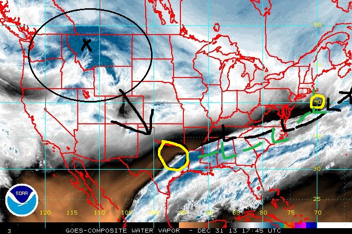 " />
" />Notice in the loop the energy has pretty decent momentum. We have to hope that the northern piece comes in with enough inertia to cause additional amplification as it rounds the base of the trough and interacts with the STJ causing the trough axis to go neg in order to still get Godzilla. Not likely but I still feel like the next 24-36 hrs holds a slight NW trend despite the last 24 hrs. Positioning changes of the key players of a mere 50-75 miles could be the difference of increasing or decreasing totals by as much as 3-5" or more. I think if the focus of energy can concentrate enough at the base of the trough instead of the some of the energy escaping out ahead of it there could be enough energy to raise heights out ahead of it without the NAO's help. I forget the term for that but it is an actual thing.
 " />" />
_________________
"In weather and in life, there's no winning and losing; there's only winning and learning."
WINTER 2012/2013 TOTALS 43.65"WINTER 2017/2018 TOTALS 62.85" WINTER 2022/2023 TOTALS 4.9"
WINTER 2013/2014 TOTALS 64.85"WINTER 2018/2019 TOTALS 14.25" WINTER 2023/2024 TOTALS 13.1"
WINTER 2014/2015 TOTALS 71.20"WINTER 2019/2020 TOTALS 6.35"
WINTER 2015/2016 TOTALS 35.00"WINTER 2020/2021 TOTALS 37.75"
WINTER 2016/2017 TOTALS 42.25"WINTER 2021/2022 TOTALS 31.65"

sroc4- Admin
- Posts : 8331
Reputation : 301
Join date : 2013-01-07
Location : Wading River, LI
Re: January 2nd-3rd Potential Snowstorm
![]() by Frank_Wx Tue Dec 31, 2013 2:22 pm
by Frank_Wx Tue Dec 31, 2013 2:22 pm
This thread has run its course, lets switch to the other. Maybe it brings better luck
_________________
_______________________________________________________________________________________________________
CLICK HERE to view NJ Strong Snowstorm Classifications
Frank_Wx- Godzilla Seeker
- Posts : 21305
Reputation : 328
Join date : 2013-01-05
Age : 31
Location : Jersey City, NJ -
Page 23 of 23 • 1 ... 13 ... 21, 22, 23
|
|
|