
 Search
January 2nd-3rd Potential Snowstorm
Page 2 of 23 •  1, 2, 3 ... 12 ... 23
 ![]()
Re: January 2nd-3rd Potential Snowstorm
![]() by skinsfan1177 Sun Dec 29, 2013 9:01 am
by skinsfan1177 Sun Dec 29, 2013 9:01 am
skinsfan1177- Senior Enthusiast

- Posts : 4485
Join date : 2013-01-07
Re: January 2nd-3rd Potential Snowstorm
![]() by CPcantmeasuresnow Sun Dec 29, 2013 9:02 am
by CPcantmeasuresnow Sun Dec 29, 2013 9:02 am
sroc4 wrote:I still feel like with the established pattern this year the track ends up inside the BM and the coastal plain battles the R/S regardless.
I agree wholeheartedly.
Some winters the timing between the cold air and the storms is just perfect every time, 93-94, 95-96, 09-10, 10-11.
others are awful and the timing is never right 97-98, 01-02, 11-12.
So far this winter cant seem to decide one way or the other. Looking ahead I don't see this changing.
CPcantmeasuresnow- Wx Statistician Guru

- Posts : 7274
Join date : 2013-01-07
Re: January 2nd-3rd Potential Snowstorm
![]() by Quietace Sun Dec 29, 2013 9:13 am
by Quietace Sun Dec 29, 2013 9:13 am
Even if its established cold, the ESE wind from a weak low, with no phase to wrap cold air into the system would warm all levels and create issues for some coastal areas.skinsfan1177 wrote:I thought at around this time along the coast the cold air will be established and when I say established really cold not marginal. So in that case it wouldn't matter it would be snow IMO

Quietace- Meteorologist - Mod

- Posts : 3687
Reputation : 33
Join date : 2013-01-07
Age : 27
Location : Point Pleasant, NJ
Re: January 2nd-3rd Potential Snowstorm
![]() by sroc4 Sun Dec 29, 2013 9:19 am
by sroc4 Sun Dec 29, 2013 9:19 am
Starting as snow is likely but if the southern energy is too close to the coast while it strengthens the strong SE and easterly flow will warm the mid levels quickly as it has done all season long. I'm not saying its a lock that this happens, simply that given the well established pattern we have been in it seems likely to me. The coast is still likely to see some snow, but without the phase with the Northern stream south of us there is no way for the cold air to wrap into the core of the system. Without that if the southern LP is strong enough, which again seems to be stronger than modeled once it arrives along the coast, the warmer Atlantic air wins out in the mid levels of the system.skinsfan1177 wrote:I thought at around this time along the coast the cold air will be established and when I say established really cold not marginal. So in that case it wouldn't matter it would be snow IMO
_________________
"In weather and in life, there's no winning and losing; there's only winning and learning."
WINTER 2012/2013 TOTALS 43.65"WINTER 2017/2018 TOTALS 62.85" WINTER 2022/2023 TOTALS 4.9"
WINTER 2013/2014 TOTALS 64.85"WINTER 2018/2019 TOTALS 14.25" WINTER 2023/2024 TOTALS 13.1"
WINTER 2014/2015 TOTALS 71.20"WINTER 2019/2020 TOTALS 6.35"
WINTER 2015/2016 TOTALS 35.00"WINTER 2020/2021 TOTALS 37.75"
WINTER 2016/2017 TOTALS 42.25"WINTER 2021/2022 TOTALS 31.65"

sroc4- Admin

- Posts : 8331
Reputation : 301
Join date : 2013-01-07
Location : Wading River, LI
Re: January 2nd-3rd Potential Snowstorm
![]() by skinsfan1177 Sun Dec 29, 2013 10:23 am
by skinsfan1177 Sun Dec 29, 2013 10:23 am

skinsfan1177- Senior Enthusiast
- Posts : 4485
Reputation : 35
Join date : 2013-01-07
Age : 46
Location : Point Pleasant Boro
Re: January 2nd-3rd Potential Snowstorm
![]() by tigernumba1 Sun Dec 29, 2013 11:59 am
by tigernumba1 Sun Dec 29, 2013 11:59 am

tigernumba1- Posts : 298
Reputation : 1
Join date : 2013-11-22
Age : 29
Location : East Northport, NY, 11731
Re: January 2nd-3rd Potential Snowstorm
![]() by RJB8525 Sun Dec 29, 2013 12:21 pm
by RJB8525 Sun Dec 29, 2013 12:21 pm

lol

Accuweather wants early milk and bread store rushes?

RJB8525- Senior Enthusiast
- Posts : 1994
Reputation : 28
Join date : 2013-02-06
Age : 38
Location : Hackettstown, NJ
Re: January 2nd-3rd Potential Snowstorm
![]() by sabamfa Sun Dec 29, 2013 12:36 pm
by sabamfa Sun Dec 29, 2013 12:36 pm
sabamfa- Pro Enthusiast

- Posts : 246
Reputation : 2
Join date : 2013-11-05
Age : 37
Location : Wayne, NJ
Re: January 2nd-3rd Potential Snowstorm
![]() by Pauledangerously Sun Dec 29, 2013 1:10 pm
by Pauledangerously Sun Dec 29, 2013 1:10 pm
RJB8525 wrote:
lol
Accuweather wants early milk and bread store rushes?
They seem to have changed their tune. Silly Inaccuweather.

Pauledangerously- Posts : 11
Reputation : 0
Join date : 2013-12-13
Location : Jersey City,NJ
Re: January 2nd-3rd Potential Snowstorm
![]() by docstox12 Sun Dec 29, 2013 1:16 pm
by docstox12 Sun Dec 29, 2013 1:16 pm
RJB8525 wrote:
lol
Accuweather wants early milk and bread store rushes?
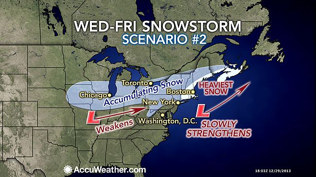
Looks like a chance of a good snowstorm here but the low must strenghten way south of us rather than off the Jersey Coast with New England getting the blast and us light snow or flurries.New England gets hit with both scenarios.
Lot's of time to see how this comes together, but there IS a chance!

docstox12- Wx Statistician Guru
- Posts : 8505
Reputation : 222
Join date : 2013-01-07
Age : 73
Location : Monroe NY
Re: January 2nd-3rd Potential Snowstorm
![]() by CPcantmeasuresnow Sun Dec 29, 2013 1:58 pm
by CPcantmeasuresnow Sun Dec 29, 2013 1:58 pm

CPcantmeasuresnow- Wx Statistician Guru
- Posts : 7274
Reputation : 230
Join date : 2013-01-07
Age : 103
Location : Eastern Orange County, NY
Re: January 2nd-3rd Potential Snowstorm
![]() by algae888 Sun Dec 29, 2013 2:07 pm
by algae888 Sun Dec 29, 2013 2:07 pm

algae888- Advanced Forecaster

- Posts : 5311
Reputation : 46
Join date : 2013-02-05
Age : 61
Location : mt. vernon, new york
Re: January 2nd-3rd Potential Snowstorm
![]() by algae888 Sun Dec 29, 2013 2:11 pm
by algae888 Sun Dec 29, 2013 2:11 pm
algae888- Advanced Forecaster
- Posts : 5311
Reputation : 46
Join date : 2013-02-05
Age : 61
Location : mt. vernon, new york
Re: January 2nd-3rd Potential Snowstorm
![]() by jmanley32 Sun Dec 29, 2013 2:11 pm
by jmanley32 Sun Dec 29, 2013 2:11 pm

jmanley32- Senior Enthusiast
- Posts : 20516
Reputation : 108
Join date : 2013-12-12
Age : 42
Location : Yonkers, NY
Re: January 2nd-3rd Potential Snowstorm
![]() by jmanley32 Sun Dec 29, 2013 2:14 pm
by jmanley32 Sun Dec 29, 2013 2:14 pm
jmanley32- Senior Enthusiast
- Posts : 20516
Reputation : 108
Join date : 2013-12-12
Age : 42
Location : Yonkers, NY
Re: January 2nd-3rd Potential Snowstorm
![]() by Quietace Sun Dec 29, 2013 2:31 pm
by Quietace Sun Dec 29, 2013 2:31 pm
Guidance is all over the place with this system. Their is no similarities between models. All handle this system differently. Once sampling becomes available of the northern stream, guidance will get a better idea of how to handle this.jmanley32 wrote:What do you all think? Major snowstorm or in between, I don't personally think it will be nothing.
Until we get that, which is still day or two away, models will not completely begin to converge(Trends will likely begin tomorrow at the 12z's.)
This is a complex Miller B system, which as I feel, are the worst to try to forecast for, as a extremely large amount of error can go wrong with these transfers.
Last edited by Quietace on Sun Dec 29, 2013 2:35 pm; edited 1 time in total
Quietace- Meteorologist - Mod
- Posts : 3687
Reputation : 33
Join date : 2013-01-07
Age : 27
Location : Point Pleasant, NJ
Re: January 2nd-3rd Potential Snowstorm
![]() by Quietace Sun Dec 29, 2013 2:34 pm
by Quietace Sun Dec 29, 2013 2:34 pm
The GFS was very weak and disjointed though. Would need a cleaner transfer of energy and a more south intensification of the Center to get some sizable precip back into the area, which is the problem with Miller B's, their always can be a screw zone with the precip shield as you know.CPcantmeasuresnow wrote:The 12z GFS had this moving away very slowly once it got off jersey coast. That scenario would play out very well for LI and parts of Hudson valley.
Quietace- Meteorologist - Mod
- Posts : 3687
Reputation : 33
Join date : 2013-01-07
Age : 27
Location : Point Pleasant, NJ
Re: January 2nd-3rd Potential Snowstorm
![]() by amugs Sun Dec 29, 2013 2:47 pm
by amugs Sun Dec 29, 2013 2:47 pm
Quietace wrote:Guidance is all over the place with this system. Their is no similarities between models. All handle this system differently. Once sampling becomes available of the northern stream, guidance will get a better idea of how to handle this.jmanley32 wrote:What do you all think? Major snowstorm or in between, I don't personally think it will be nothing.
Until we get that, which is still day or two away, models will not completely begin to converge(Trends will likely begin tomorrow at the 12z's.)
This is a complex Miller B system, which as I feel, are the worst to try to forecast for, as a extremely large amount of error can go wrong with these transfers.
The Primary hangs on too long on the Euro . The GFS surface depiction was perfect for us. Even though the op was bad aloft the ensembles looked good. the Navgem has it. The GGEM doesn't .
So since there's Zero continuity from run to run means don't etch any of these in stone
The models are having a hard time figuring the strength of the PV and how fast the southern feature takes over.
Mayhem means a hold for now
_________________
Mugs
AKA:King: Snow Weenie
Self Proclaimed
WINTER 2014-15 : 55.12" +.02 for 6 coatings (avg. 35")
WINTER 2015-16 Total - 29.8" (Avg 35")
WINTER 2016-17 : 39.5" so far

amugs- Advanced Forecaster - Mod

- Posts : 15093
Reputation : 213
Join date : 2013-01-07
Age : 54
Location : Hillsdale,NJ
Re: January 2nd-3rd Potential Snowstorm
![]() by amugs Sun Dec 29, 2013 2:53 pm
by amugs Sun Dec 29, 2013 2:53 pm

\
From HPC
_________________
Mugs
AKA:King: Snow Weenie
Self Proclaimed
WINTER 2014-15 : 55.12" +.02 for 6 coatings (avg. 35")
WINTER 2015-16 Total - 29.8" (Avg 35")
WINTER 2016-17 : 39.5" so far
amugs- Advanced Forecaster - Mod
- Posts : 15093
Reputation : 213
Join date : 2013-01-07
Age : 54
Location : Hillsdale,NJ
Re: January 2nd-3rd Potential Snowstorm
![]() by Quietace Sun Dec 29, 2013 2:56 pm
by Quietace Sun Dec 29, 2013 2:56 pm
Pretty much what i just said. Ensemble spread on the models are huge. Their is no agreement to the Operational, except for the mean, but that's due to having extremes on both sides on the ensembles which is crazy.The thread the needle pattern and trying to forecast how the confluence sets up is really testing guidance right now.amugs wrote:Quietace wrote:Guidance is all over the place with this system. Their is no similarities between models. All handle this system differently. Once sampling becomes available of the northern stream, guidance will get a better idea of how to handle this.jmanley32 wrote:What do you all think? Major snowstorm or in between, I don't personally think it will be nothing.
Until we get that, which is still day or two away, models will not completely begin to converge(Trends will likely begin tomorrow at the 12z's.)
This is a complex Miller B system, which as I feel, are the worst to try to forecast for, as a extremely large amount of error can go wrong with these transfers.
The Primary hangs on too long on the Euro . The GFS surface depiction was perfect for us. Even though the op was bad aloft the ensembles looked good. the Navgem has it. The GGEM doesn't .
So since there's Zero continuity from run to run means don't etch any of these in stone
The models are having a hard time figuring the strength of the PV and how fast the southern feature takes over.
Mayhem means a hold for now
Quietace- Meteorologist - Mod
- Posts : 3687
Reputation : 33
Join date : 2013-01-07
Age : 27
Location : Point Pleasant, NJ
Re: January 2nd-3rd Potential Snowstorm
![]() by amugs Sun Dec 29, 2013 3:25 pm
by amugs Sun Dec 29, 2013 3:25 pm
_________________
Mugs
AKA:King: Snow Weenie
Self Proclaimed
WINTER 2014-15 : 55.12" +.02 for 6 coatings (avg. 35")
WINTER 2015-16 Total - 29.8" (Avg 35")
WINTER 2016-17 : 39.5" so far
amugs- Advanced Forecaster - Mod
- Posts : 15093
Reputation : 213
Join date : 2013-01-07
Age : 54
Location : Hillsdale,NJ
Re: January 2nd-3rd Potential Snowstorm
![]() by Dunnzoo Sun Dec 29, 2013 3:29 pm
by Dunnzoo Sun Dec 29, 2013 3:29 pm
amugs wrote:You got it kid - this is going to drive us crazy - one model nada - one a big hit and then....
and then we wait until late tomorrow.
_________________
Janet
Snowfall winter of 2023-2024 17.5"
Snowfall winter of 2022-2023 6.0"
Snowfall winter of 2021-2022 17.6" 1" sleet 2/25/22
Snowfall winter of 2020-2021 51.1"
Snowfall winter of 2019-2020 8.5"
Snowfall winter of 2018-2019 25.1"
Snowfall winter of 2017-2018 51.9"
Snowfall winter of 2016-2017 45.6"
Snowfall winter of 2015-2016 29.5"
Snowfall winter of 2014-2015 50.55"
Snowfall winter of 2013-2014 66.5"

Dunnzoo- Senior Enthusiast - Mod
- Posts : 4891
Reputation : 68
Join date : 2013-01-11
Age : 62
Location : Westwood, NJ
Re: January 2nd-3rd Potential Snowstorm
![]() by Quietace Sun Dec 29, 2013 3:34 pm
by Quietace Sun Dec 29, 2013 3:34 pm
I think i threw my hands up and cursed off each model today lol. Its frustrating....but we have to stay patient...Very hard forecast...amugs wrote:You got it kid - this is going to drive us crazy - one model nada - one a big hit and then....
Quietace- Meteorologist - Mod
- Posts : 3687
Reputation : 33
Join date : 2013-01-07
Age : 27
Location : Point Pleasant, NJ
Re: January 2nd-3rd Potential Snowstorm
![]() by Frank_Wx Sun Dec 29, 2013 3:40 pm
by Frank_Wx Sun Dec 29, 2013 3:40 pm
_________________
_______________________________________________________________________________________________________
CLICK HERE to view NJ Strong Snowstorm Classifications

Frank_Wx- Godzilla Seeker
- Posts : 21305
Reputation : 328
Join date : 2013-01-05
Age : 31
Location : Jersey City, NJ -

Re: January 2nd-3rd Potential Snowstorm
![]() by amugs Sun Dec 29, 2013 3:41 pm
by amugs Sun Dec 29, 2013 3:41 pm
Need to right click and open in a new window to see the map
_________________
Mugs
AKA:King: Snow Weenie
Self Proclaimed
WINTER 2014-15 : 55.12" +.02 for 6 coatings (avg. 35")
WINTER 2015-16 Total - 29.8" (Avg 35")
WINTER 2016-17 : 39.5" so far
amugs- Advanced Forecaster - Mod
- Posts : 15093
Reputation : 213
Join date : 2013-01-07
Age : 54
Location : Hillsdale,NJ
Re: January 2nd-3rd Potential Snowstorm
![]() by Quietace Sun Dec 29, 2013 3:54 pm
by Quietace Sun Dec 29, 2013 3:54 pm
12z Euro Ensemble meanamugs wrote:Got this map from another site H5 ensemble mean seems a bit more favorable, and overall, not a bad look - looks to transfer the primary from Ky to the secondary low just off the Ocean City MD area and it moves slowly to the benchmark - we shall see.... tomorrow ....Tuesday and then
Need to right click and open in a new window to see the map

Quietace- Meteorologist - Mod
- Posts : 3687
Reputation : 33
Join date : 2013-01-07
Age : 27
Location : Point Pleasant, NJ
Re: January 2nd-3rd Potential Snowstorm
![]() by Frank_Wx Sun Dec 29, 2013 3:55 pm
by Frank_Wx Sun Dec 29, 2013 3:55 pm
Looking at the 12z EURO for the first time today...up to 96 hours, everything looks pretty good

We have the nice ridge in the west (too bad it's not north-south orientation but it'll do) with the confluence west-northwest of Nova Scotia. The EURO did back away from the STJ interaction though, which is what the GFS has been saying.
However...
What you do see from the H5 map above is the piece of s/w wedged in between the north Pac. ridge and the western U.S. ridge, also known as a kicker. This kicker is basically flattening the western ridge and pushing it into the Midwest.

Fast forward to hour 120, the confluence area near Nova Scotia has dramatically weakened and the +PNA is not nearly as amplified. You can see the storm on the east coast is close though. If we can just slow things down by 6 hours or so and get the phase in quicker with the northern stream energies, it should produce a favorable outcome.
In my opinion, I do not think the confluence area will "die" as quickly as these OP models are suggesting. I think this will be a Miller B, but the transfer will occur further south. That is pretty much what the ensembles are doing.
We'll see what happens...
_________________
_______________________________________________________________________________________________________
CLICK HERE to view NJ Strong Snowstorm Classifications
Frank_Wx- Godzilla Seeker
- Posts : 21305
Reputation : 328
Join date : 2013-01-05
Age : 31
Location : Jersey City, NJ -
Page 2 of 23 • 1, 2, 3 ... 12 ... 23 ![]()
|
|
|