BLOG: March 12th-13th Potential Snowstorm, Discussion Thread 1.0
+25
Grselig
Quietace
2004blackwrx
jimv45
NjWeatherGuy
nancy-j-s
docstox12
mancave25
Yschiff
nutleyblizzard
algae888
SNOW MAN
oldtimer
sroc4
Artechmetals
amugs
Dunnzoo
essexcountypete
mako460
CPcantmeasuresnow
SoulSingMG
pdubz
jmanley32
Ronniek
Frank_Wx
29 posters
Page 12 of 12
Page 12 of 12 •  1, 2, 3 ... 10, 11, 12
 Re: BLOG: March 12th-13th Potential Snowstorm, Discussion Thread 1.0
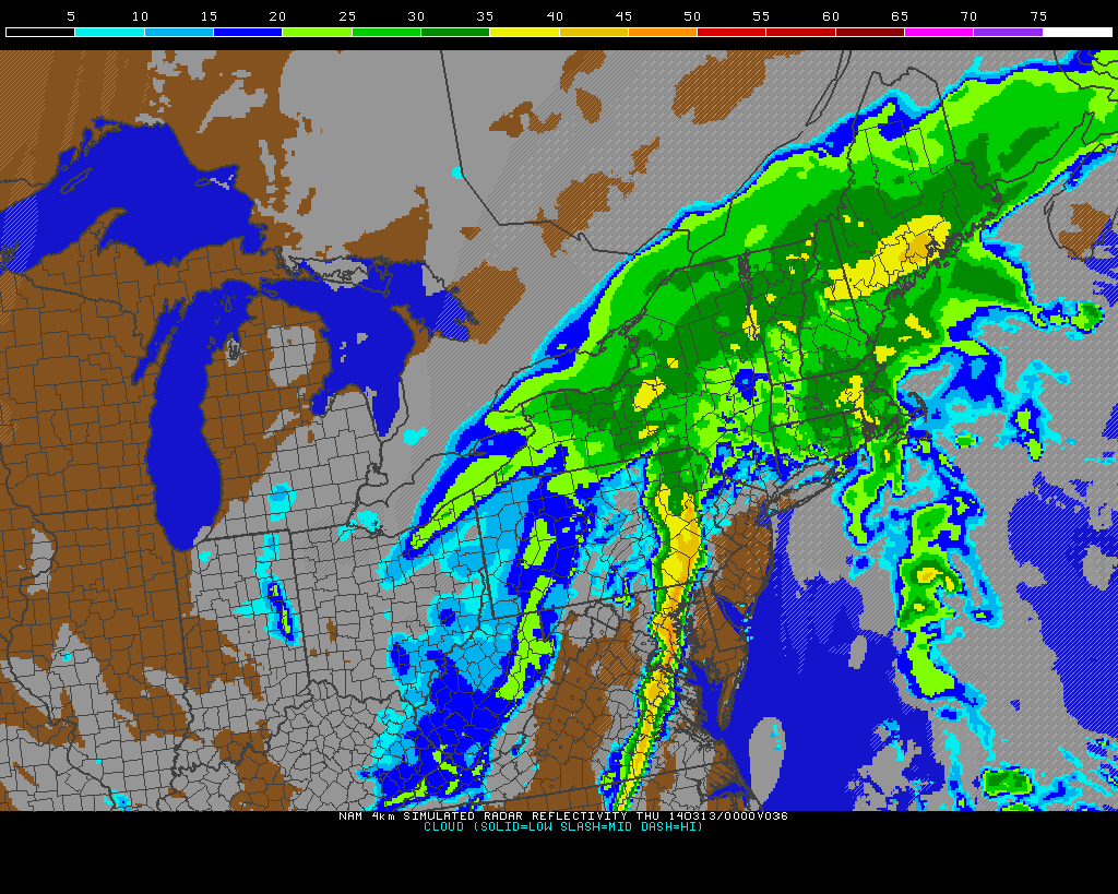
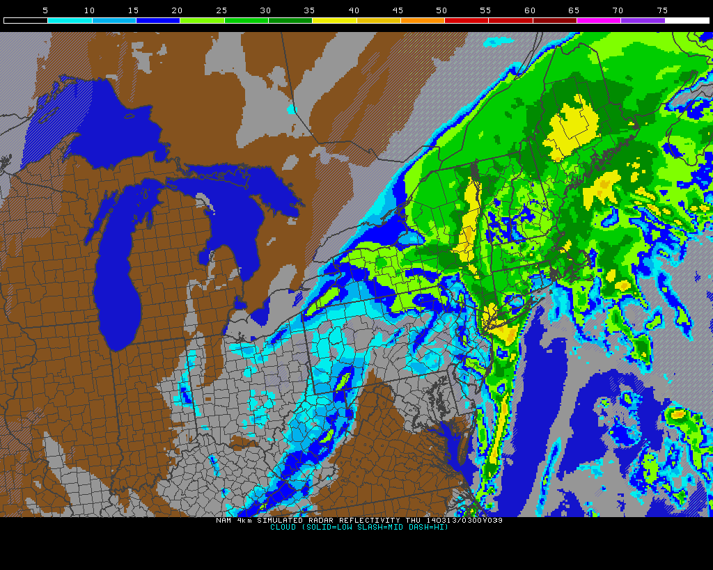
Accuwx has us changing to snow still, "slippery travel " I can'rt believe the amounts NAM is showing up north, crazy but mets are keeping it low comparatively even NWS.
jmanley32- Senior Enthusiast

- Posts : 20513
Join date : 2013-12-12
 Re: BLOG: March 12th-13th Potential Snowstorm, Discussion Thread 1.0
Even though this event busts out for snow here, it's gonna be interesting tomorrow night.Temps plunge from the 50's to the teens, 40-50 MPH winds, possible thunderstorms maybe even a heavy snow squall or two.Great for observing.
docstox12- Wx Statistician Guru

- Posts : 8502
Join date : 2013-01-07
 Re: BLOG: March 12th-13th Potential Snowstorm, Discussion Thread 1.0
docstox12 wrote:Even though this event busts out for snow here, it's gonna be interesting tomorrow night.Temps plunge from the 50's to the teens, 40-50 MPH winds, possible thunderstorms maybe even a heavy snow squall or two.Great for observing.
Yep, they may be skiing till May in the Adirondacks of NY if some of the models are true. Looks like 30 inches plus up there.

CPcantmeasuresnow- Wx Statistician Guru

- Posts : 7274
Reputation : 230
Join date : 2013-01-07
Age : 103
Location : Eastern Orange County, NY
 Re: BLOG: March 12th-13th Potential Snowstorm, Discussion Thread 1.0
yeah doc im still a little psyched that theres not going to be no wx. Wind is cool, and def t-storms although dunno if they make it into southern westchester, but does say for NYC so its really close to me. I am hearing conflicting onfo about t-storms some people on bloghs etc say there is no chance but I tend to trust in you all here as your all a very smart bunch and almost always get it right.

jmanley32- Senior Enthusiast

- Posts : 20513
Reputation : 108
Join date : 2013-12-12
Age : 42
Location : Yonkers, NY
 Re: BLOG: March 12th-13th Potential Snowstorm, Discussion Thread 1.0
SPC expanded the t-storm area to include very much of the Mid-Atl and northern Mid-Atl area including the entire viewing area.
NjWeatherGuy- Advanced Forecaster

- Posts : 4100
Reputation : 28
Join date : 2013-01-06
Location : Belle Mead, NJ
 Re: BLOG: March 12th-13th Potential Snowstorm, Discussion Thread 1.0
amugs wrote:Homemade Baileys from the KSW aka Mugs
2 cups of light cream
1-1.5 cups of any whiskey
1 cup of milk
2 tbsp of vanilla extract
2-3 tbsp of Hershey's syrup
1 can of condensed milk
If in a pinch or like to save n a coin use baileys 16 oz creamer in the dairy aisle works in place of the cream
To make even creamier add a scoop or two of coffee or vanilla ice cream
Shake up real good chill and enjoy!
Thanks, Mugs!!!!
sabamfa- Pro Enthusiast

- Posts : 246
Reputation : 2
Join date : 2013-11-05
Age : 37
Location : Wayne, NJ
 Re: BLOG: March 12th-13th Potential Snowstorm, Discussion Thread 1.0
NWS Revised
THE OTHER CONCERN IS THUNDERSTORMS AHEAD OF AND
WITH THE FRONT. THOUGH INSTABILITY IS VERY LIMITED, MU CAPE VALUES
LESS THAN 500 J/KG, GIVEN THE IMPRESSIVE LOW AND MID LEVEL FLOW,
GUSTY WINDS WILL BE POSSIBLE ESPECIALLY IF A LINE OF STORMS
DEVELOPS ALONG THE FRONT, AND IS ABLE TO TRANSLATE THE LOW LEVEL
JET DOWN TO THE SURFACE.

NjWeatherGuy- Advanced Forecaster

- Posts : 4100
Reputation : 28
Join date : 2013-01-06
Location : Belle Mead, NJ

NjWeatherGuy- Advanced Forecaster

- Posts : 4100
Reputation : 28
Join date : 2013-01-06
Location : Belle Mead, NJ
 Re: BLOG: March 12th-13th Potential Snowstorm, Discussion Thread 1.0

Tom you may need to get your car ready - tornado threat albeit slight right near you!
Norman OK Update
WITH THE EXIT REGION OF A 70-90-KT H5 JET CORE OVERSPREADING THE
WARM SECTOR BUOYANCY ABOVE A SWLY LLJ INCREASING TO 50-60 KT...WIND
PROFILES WILL BE FAVORABLE FOR LOW-TOPPED...ORGANIZED CONVECTION.
THUNDERSTORMS ARE EXPECTED TO BECOME ORGANIZED INTO FAST MOVING
QUASI-LINEAR SEGMENTS WITH EMBEDDED LEWP STRUCTURES INVOF THE COLD
FRONT. STRONG CONVECTIVE MOMENTUM TRANSPORT WILL SUPPORT THE
POTENTIAL FOR DAMAGING WIND GUSTS...WITH THIS POTENTIAL BOLSTERED BY
THE STRONG CROSS-FRONTAL...SYNOPTIC PRESSURE RISE-FALL COUPLET.
STRONG LOW-LEVEL SHEAR -- E.G. AROUND 30-40 KT OF 0-1-KM BULK
SHEAR -- WILL SUPPORT SOME POTENTIAL FOR LINE-EMBEDDED MESOVORTICES
TO PRODUCE TORNADOES.
_________________
Mugs
AKA:King: Snow Weenie
Self Proclaimed
WINTER 2014-15 : 55.12" +.02 for 6 coatings (avg. 35")
WINTER 2015-16 Total - 29.8" (Avg 35")
WINTER 2016-17 : 39.5" so far

amugs- Advanced Forecaster - Mod

- Posts : 15093
Reputation : 213
Join date : 2013-01-07
Age : 54
Location : Hillsdale,NJ
 Re: BLOG: March 12th-13th Potential Snowstorm, Discussion Thread 1.0
amugs wrote:
Tom you may need to get your car ready - tornado threat albeit slight right near you!
Norman OK Update
WITH THE EXIT REGION OF A 70-90-KT H5 JET CORE OVERSPREADING THE
WARM SECTOR BUOYANCY ABOVE A SWLY LLJ INCREASING TO 50-60 KT...WIND
PROFILES WILL BE FAVORABLE FOR LOW-TOPPED...ORGANIZED CONVECTION.
THUNDERSTORMS ARE EXPECTED TO BECOME ORGANIZED INTO FAST MOVING
QUASI-LINEAR SEGMENTS WITH EMBEDDED LEWP STRUCTURES INVOF THE COLD
FRONT. STRONG CONVECTIVE MOMENTUM TRANSPORT WILL SUPPORT THE
POTENTIAL FOR DAMAGING WIND GUSTS...WITH THIS POTENTIAL BOLSTERED BY
THE STRONG CROSS-FRONTAL...SYNOPTIC PRESSURE RISE-FALL COUPLET.
STRONG LOW-LEVEL SHEAR -- E.G. AROUND 30-40 KT OF 0-1-KM BULK
SHEAR -- WILL SUPPORT SOME POTENTIAL FOR LINE-EMBEDDED MESOVORTICES
TO PRODUCE TORNADOES.
Interesting, this morning they didn't even have a tornado circle or any mention of them. We'll see!

NjWeatherGuy- Advanced Forecaster

- Posts : 4100
Reputation : 28
Join date : 2013-01-06
Location : Belle Mead, NJ
 Re: BLOG: March 12th-13th Potential Snowstorm, Discussion Thread 1.0
UPTON is thinking a snow storm here Sun night into Monday...
12Z ECMWF HAS TRENDED TOWARDS 12Z CMC SOLUTION OF A LOW DEVELOPING
OVER THE SE STATES SUNDAY...THEN TRACKING NE OFF THE MID-ATLANTIC
AND NE COASTS SUNDAY NIGHT-MONDAY. THE GFS HOWEVER DOES NOT SHOW
AS MUCH INTERACTION WITH A SOUTHERN PROTUBERANCE OF THE POLAR
VORTEX AND A SOUTHERN STREAM SHORTWAVE...KEEPING THE STORM WELL
TO THE S AND E. GIVEN THE OVERALL SUPERIOR PERFORMANCE OF BOTH THE
CMC AND ECMWF IN THE EXTENDED OVER THE GFS SO FAR THIS YEAR IN THE
LONG TERM...HAVE FAVORED A BLEND OF THE ECMWF/CMC FROM SUNDAY
NIGHT-TUESDAY.
BASED ON THIS BRING IN CHANCE POPS FOR MAINLY SNOW...POSSIBLY
MIXED WITH RAIN TO START ACROSS NYC AND MAYBE LONG ISLAND LATE
SUNDAY EVENING...THEN HAVE A CHANCE OF SNOW FOR ALL ZONES FROM
LATE SUNDAY NIGHT THROUGH MONDAY...WITH ONLY SLIGHT CHANCE POPS
MONDAY NIGHT AS THE STORM PULLS AWAY...AND A POTENTIAL SECONDARY
LOW LIKELY TRACKS WELL TO THE S AND E. GIVEN THE UNCERTAINTY...IT
IS TOO EARLY TO SPECULATE ON AMOUNTS OR POTENTIAL IMPACT.
REMEMBER...THERE IS STILL THE POTENTIAL THAT THE GFS COULD END UP
BEING CORRECT...AND THE AREA REMAIN DRY EARLY NEXT WEEK.

SoulSingMG- Senior Enthusiast

- Posts : 2853
Reputation : 74
Join date : 2013-12-11
Location : Long Island City, NY
 Re: BLOG: March 12th-13th Potential Snowstorm, Discussion Thread 1.0
SoulSingMG wrote:UPTON is thinking a snow storm here Sun night into Monday...
12Z ECMWF HAS TRENDED TOWARDS 12Z CMC SOLUTION OF A LOW DEVELOPING
OVER THE SE STATES SUNDAY...THEN TRACKING NE OFF THE MID-ATLANTIC
AND NE COASTS SUNDAY NIGHT-MONDAY. THE GFS HOWEVER DOES NOT SHOW
AS MUCH INTERACTION WITH A SOUTHERN PROTUBERANCE OF THE POLAR
VORTEX AND A SOUTHERN STREAM SHORTWAVE...KEEPING THE STORM WELL
TO THE S AND E. GIVEN THE OVERALL SUPERIOR PERFORMANCE OF BOTH THE
CMC AND ECMWF IN THE EXTENDED OVER THE GFS SO FAR THIS YEAR IN THE
LONG TERM...HAVE FAVORED A BLEND OF THE ECMWF/CMC FROM SUNDAY
NIGHT-TUESDAY.
BASED ON THIS BRING IN CHANCE POPS FOR MAINLY SNOW...POSSIBLY
MIXED WITH RAIN TO START ACROSS NYC AND MAYBE LONG ISLAND LATE
SUNDAY EVENING...THEN HAVE A CHANCE OF SNOW FOR ALL ZONES FROM
LATE SUNDAY NIGHT THROUGH MONDAY...WITH ONLY SLIGHT CHANCE POPS
MONDAY NIGHT AS THE STORM PULLS AWAY...AND A POTENTIAL SECONDARY
LOW LIKELY TRACKS WELL TO THE S AND E. GIVEN THE UNCERTAINTY...IT
IS TOO EARLY TO SPECULATE ON AMOUNTS OR POTENTIAL IMPACT.
REMEMBER...THERE IS STILL THE POTENTIAL THAT THE GFS COULD END UP
BEING CORRECT...AND THE AREA REMAIN DRY EARLY NEXT WEEK.
Too early and wrong thread.

NjWeatherGuy- Advanced Forecaster

- Posts : 4100
Reputation : 28
Join date : 2013-01-06
Location : Belle Mead, NJ
 Re: BLOG: March 12th-13th Potential Snowstorm, Discussion Thread 1.0
NjWeatherGuy wrote:SoulSingMG wrote:UPTON is thinking a snow storm here Sun night into Monday...
12Z ECMWF HAS TRENDED TOWARDS 12Z CMC SOLUTION OF A LOW DEVELOPING
OVER THE SE STATES SUNDAY...THEN TRACKING NE OFF THE MID-ATLANTIC
AND NE COASTS SUNDAY NIGHT-MONDAY. THE GFS HOWEVER DOES NOT SHOW
AS MUCH INTERACTION WITH A SOUTHERN PROTUBERANCE OF THE POLAR
VORTEX AND A SOUTHERN STREAM SHORTWAVE...KEEPING THE STORM WELL
TO THE S AND E. GIVEN THE OVERALL SUPERIOR PERFORMANCE OF BOTH THE
CMC AND ECMWF IN THE EXTENDED OVER THE GFS SO FAR THIS YEAR IN THE
LONG TERM...HAVE FAVORED A BLEND OF THE ECMWF/CMC FROM SUNDAY
NIGHT-TUESDAY.
BASED ON THIS BRING IN CHANCE POPS FOR MAINLY SNOW...POSSIBLY
MIXED WITH RAIN TO START ACROSS NYC AND MAYBE LONG ISLAND LATE
SUNDAY EVENING...THEN HAVE A CHANCE OF SNOW FOR ALL ZONES FROM
LATE SUNDAY NIGHT THROUGH MONDAY...WITH ONLY SLIGHT CHANCE POPS
MONDAY NIGHT AS THE STORM PULLS AWAY...AND A POTENTIAL SECONDARY
LOW LIKELY TRACKS WELL TO THE S AND E. GIVEN THE UNCERTAINTY...IT
IS TOO EARLY TO SPECULATE ON AMOUNTS OR POTENTIAL IMPACT.
REMEMBER...THERE IS STILL THE POTENTIAL THAT THE GFS COULD END UP
BEING CORRECT...AND THE AREA REMAIN DRY EARLY NEXT WEEK.
Too early and wrong thread.
Woahh, be nice. I know you don't want more snow, NJ, but it's coming before April comes. I feel it. And I agree, it's the wrong thread but it is certainly not too early to discuss this potential. It's 5 days away.

SoulSingMG- Senior Enthusiast

- Posts : 2853
Reputation : 74
Join date : 2013-12-11
Location : Long Island City, NY
 Re: BLOG: March 12th-13th Potential Snowstorm, Discussion Thread 1.0
let it snow through April lets break every record!!!

pdubz- Pro Enthusiast

- Posts : 539
Reputation : 0
Join date : 2013-09-24
Age : 32
Location : Port Washington,NY (L.I)
 Re: BLOG: March 12th-13th Potential Snowstorm, Discussion Thread 1.0
SoulSingMG wrote:UPTON is thinking a snow storm here Sun night into Monday...
12Z ECMWF HAS TRENDED TOWARDS 12Z CMC SOLUTION OF A LOW DEVELOPING
OVER THE SE STATES SUNDAY...THEN TRACKING NE OFF THE MID-ATLANTIC
AND NE COASTS SUNDAY NIGHT-MONDAY. THE GFS HOWEVER DOES NOT SHOW
AS MUCH INTERACTION WITH A SOUTHERN PROTUBERANCE OF THE POLAR
VORTEX AND A SOUTHERN STREAM SHORTWAVE...KEEPING THE STORM WELL
TO THE S AND E. GIVEN THE OVERALL SUPERIOR PERFORMANCE OF BOTH THE
CMC AND ECMWF IN THE EXTENDED OVER THE GFS SO FAR THIS YEAR IN THE
LONG TERM...HAVE FAVORED A BLEND OF THE ECMWF/CMC FROM SUNDAY
NIGHT-TUESDAY.
BASED ON THIS BRING IN CHANCE POPS FOR MAINLY SNOW...POSSIBLY
MIXED WITH RAIN TO START ACROSS NYC AND MAYBE LONG ISLAND LATE
SUNDAY EVENING...THEN HAVE A CHANCE OF SNOW FOR ALL ZONES FROM
LATE SUNDAY NIGHT THROUGH MONDAY...WITH ONLY SLIGHT CHANCE POPS
MONDAY NIGHT AS THE STORM PULLS AWAY...AND A POTENTIAL SECONDARY
LOW LIKELY TRACKS WELL TO THE S AND E. GIVEN THE UNCERTAINTY...IT
IS TOO EARLY TO SPECULATE ON AMOUNTS OR POTENTIAL IMPACT.
REMEMBER...THERE IS STILL THE POTENTIAL THAT THE GFS COULD END UP
BEING CORRECT...AND THE AREA REMAIN DRY EARLY NEXT WEEK.
I'll take back every bad thing I've said about this winter during the last couple of weeks if just one more storm would deliver.
Who am I kidding I'm never satisfied.

CPcantmeasuresnow- Wx Statistician Guru

- Posts : 7274
Reputation : 230
Join date : 2013-01-07
Age : 103
Location : Eastern Orange County, NY
 Re: BLOG: March 12th-13th Potential Snowstorm, Discussion Thread 1.0
Yeah totally agree with you pdubz that let it snow through and lets break every record... 
amyjustice12- Posts : 1
Reputation : 0
Join date : 2014-04-29
Page 12 of 12 •  1, 2, 3 ... 10, 11, 12
Page 12 of 12
Permissions in this forum:
You cannot reply to topics in this forum|
|
|

 Home
Home