
 Search
Official Long Range Thread 3.0
Page 30 of 32 •  1 ... 16 ... 29, 30, 31, 32
 ![]()
Re: Official Long Range Thread 3.0
![]() by jmanley32 Sat Oct 25, 2014 3:01 pm
by jmanley32 Sat Oct 25, 2014 3:01 pm
jmanley32- Senior Enthusiast

- Posts : 20517
Join date : 2013-12-12
Re: Official Long Range Thread 3.0
![]() by amugs Sat Oct 25, 2014 3:06 pm
by amugs Sat Oct 25, 2014 3:06 pm
A lot of time but can't wait for this hype to hit the net and social media - I am patiently going to wait but one thing is f or sure after we hit 70's Tuesday (?) then by Thurs morning we are looking at a freeze for the metro area and weekend looks cold low to mid 40's for NYC metro - id teh data is correct - time will tell.
amugs- Advanced Forecaster - Mod

- Posts : 15093
Join date : 2013-01-07
Re: Official Long Range Thread 3.0
![]() by jmanley32 Sat Oct 25, 2014 3:07 pm
by jmanley32 Sat Oct 25, 2014 3:07 pm

jmanley32- Senior Enthusiast
- Posts : 20517
Reputation : 108
Join date : 2013-12-12
Age : 42
Location : Yonkers, NY
Re: Official Long Range Thread 3.0
![]() by jmanley32 Sat Oct 25, 2014 3:09 pm
by jmanley32 Sat Oct 25, 2014 3:09 pm
jmanley32- Senior Enthusiast
- Posts : 20517
Reputation : 108
Join date : 2013-12-12
Age : 42
Location : Yonkers, NY
Re: Official Long Range Thread 3.0
![]() by amugs Sat Oct 25, 2014 3:50 pm
by amugs Sat Oct 25, 2014 3:50 pm
Things are "POSSIBLE" not a given.
I have learned that over the years of reading about big storms they usually come when the AO and NAO are going from a decently negative state to a neutral slightly positive state and that is what is occurring. There are a few other factors as well -+PNA for one but I am not counting any chickens just yet - we get to Tues 00Z & Wed 6Z and 12Z runs ugh we still see this then we can start but in the mean time I am enjoying the great fall weather.
AO was a neg 4 + and NAO was a 3+ - analogs being PD storm, Nemo
_________________
Mugs
AKA:King: Snow Weenie
Self Proclaimed
WINTER 2014-15 : 55.12" +.02 for 6 coatings (avg. 35")
WINTER 2015-16 Total - 29.8" (Avg 35")
WINTER 2016-17 : 39.5" so far

amugs- Advanced Forecaster - Mod
- Posts : 15093
Reputation : 213
Join date : 2013-01-07
Age : 54
Location : Hillsdale,NJ
Re: Official Long Range Thread 3.0
![]() by jmanley32 Sat Oct 25, 2014 4:22 pm
by jmanley32 Sat Oct 25, 2014 4:22 pm
jmanley32- Senior Enthusiast
- Posts : 20517
Reputation : 108
Join date : 2013-12-12
Age : 42
Location : Yonkers, NY
Re: Official Long Range Thread 3.0
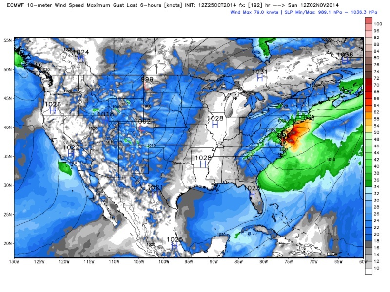
![]() by Frank_Wx Sat Oct 25, 2014 4:26 pm
by Frank_Wx Sat Oct 25, 2014 4:26 pm

Holy crap. The EURO once again closes off H5 like it did this past week to form another coastal storm. This time, there is colder air involved due to the amplitude of the polar stream energy diving into the eastern CONUS. It's not exactly a clean phase since some energy scoots ahead of the primary surface low, but there does appear to be a Miller-B component to the storm with how it transfers energy off the coast.
Still in the early stages. The GFS keeps both streams separate still. The GFS has a bias of being too progressive, so a phased out storm given the way the western ridge looks would not shock me. However, determining how the phase evolves will be key. A clean phase would develop a strong system capable of manufacturing it's own cold air. Would be a lot of dynamics involved. I don't think that will happen since the blocking doesn't impress me. But we'll see.
_________________
_______________________________________________________________________________________________________
CLICK HERE to view NJ Strong Snowstorm Classifications

Frank_Wx- Godzilla Seeker

- Posts : 21305
Reputation : 328
Join date : 2013-01-05
Age : 31
Location : Jersey City, NJ -

Re: Official Long Range Thread 3.0
![]() by sroc4 Sat Oct 25, 2014 4:28 pm
by sroc4 Sat Oct 25, 2014 4:28 pm

_________________
"In weather and in life, there's no winning and losing; there's only winning and learning."
WINTER 2012/2013 TOTALS 43.65"WINTER 2017/2018 TOTALS 62.85" WINTER 2022/2023 TOTALS 4.9"
WINTER 2013/2014 TOTALS 64.85"WINTER 2018/2019 TOTALS 14.25" WINTER 2023/2024 TOTALS 13.1"
WINTER 2014/2015 TOTALS 71.20"WINTER 2019/2020 TOTALS 6.35"
WINTER 2015/2016 TOTALS 35.00"WINTER 2020/2021 TOTALS 37.75"
WINTER 2016/2017 TOTALS 42.25"WINTER 2021/2022 TOTALS 31.65"

sroc4- Admin
- Posts : 8331
Reputation : 301
Join date : 2013-01-07
Location : Wading River, LI
Re: Official Long Range Thread 3.0
![]() by sroc4 Sat Oct 25, 2014 4:37 pm
by sroc4 Sat Oct 25, 2014 4:37 pm
Frank_Wx wrote:
Holy crap. The EURO once again closes off H5 like it did this past week to form another coastal storm. This time, there is colder air involved due to the amplitude of the polar stream energy diving into the eastern CONUS. It's not exactly a clean phase since some energy scoots ahead of the primary surface low, but there does appear to be a Miller-B component to the storm with how it transfers energy off the coast.
Still in the early stages. The GFS keeps both streams separate still. The GFS has a bias of being too progressive, so a phased out storm given the way the western ridge looks would not shock me. However, determining how the phase evolves will be key. A clean phase would develop a strong system capable of manufacturing it's own cold air. Would be a lot of dynamics involved. I don't think that will happen since the blocking doesn't impress me. But we'll see.
GFS def has had the southern stream progressive bias. The CMC is on board now with a nice amped ridge compared to its 00z. Still not going to believe the hype just yet but there is def some percolation going on inside these bones.
_________________
"In weather and in life, there's no winning and losing; there's only winning and learning."
WINTER 2012/2013 TOTALS 43.65"WINTER 2017/2018 TOTALS 62.85" WINTER 2022/2023 TOTALS 4.9"
WINTER 2013/2014 TOTALS 64.85"WINTER 2018/2019 TOTALS 14.25" WINTER 2023/2024 TOTALS 13.1"
WINTER 2014/2015 TOTALS 71.20"WINTER 2019/2020 TOTALS 6.35"
WINTER 2015/2016 TOTALS 35.00"WINTER 2020/2021 TOTALS 37.75"
WINTER 2016/2017 TOTALS 42.25"WINTER 2021/2022 TOTALS 31.65"
sroc4- Admin
- Posts : 8331
Reputation : 301
Join date : 2013-01-07
Location : Wading River, LI
Re: Official Long Range Thread 3.0
![]() by Frank_Wx Sat Oct 25, 2014 4:40 pm
by Frank_Wx Sat Oct 25, 2014 4:40 pm
#1 is shown by the GFS of keeping the northern and southern streams separate which would not promote cyclogenesis. The likely outcome would be rain/snow showers from the H5 vort within the trough. Also some intense cold air to follow.
#2 is depicted by the EURO with the southern stream energy (which ejects out of the polar jet stream and digs into the southeastern US) phasing with the northern stream vort. It's not exactly a clean phase since some H5 energy scoots ahead of the main complex, but it still evolves a coastal storm nonetheless and there may be a Miller-B component involved, verbatim.
#3 is not really shown on any model and likely won't happen due to insufficient blocking, but that would be more of a Miller-A type with intense dynamics. Don't expect that to happen.
_________________
_______________________________________________________________________________________________________
CLICK HERE to view NJ Strong Snowstorm Classifications
Frank_Wx- Godzilla Seeker
- Posts : 21305
Reputation : 328
Join date : 2013-01-05
Age : 31
Location : Jersey City, NJ -
Re: Official Long Range Thread 3.0
![]() by Quietace Sat Oct 25, 2014 4:41 pm
by Quietace Sat Oct 25, 2014 4:41 pm
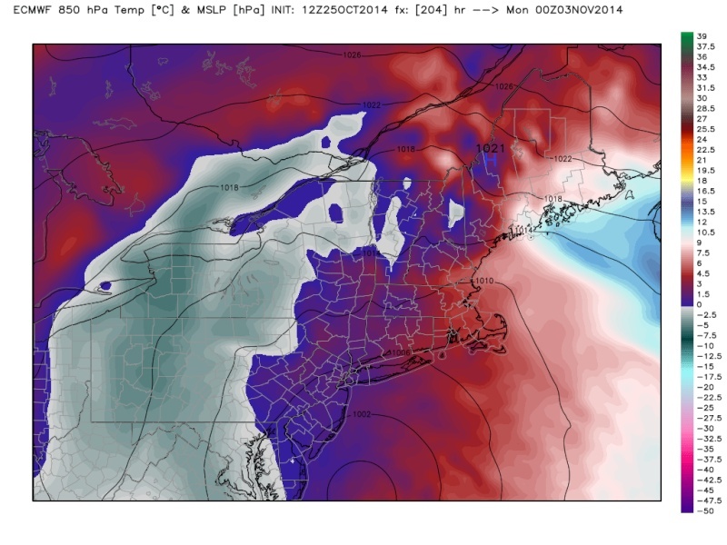
Verbatim, 850s on the Euro are cold for the track and phase. I was suprised to see 850s only near +1.5*c in most of the area. As you said a clean phase and better low position may bring frozen precip closer to the tri-state with that strong of a Low. Interesting early season setup. Time to stay up late and follow models closer for me.Frank_Wx wrote:
Holy crap. The EURO once again closes off H5 like it did this past week to form another coastal storm. This time, there is colder air involved due to the amplitude of the polar stream energy diving into the eastern CONUS. It's not exactly a clean phase since some energy scoots ahead of the primary surface low, but there does appear to be a Miller-B component to the storm with how it transfers energy off the coast.
Still in the early stages. The GFS keeps both streams separate still. The GFS has a bias of being too progressive, so a phased out storm given the way the western ridge looks would not shock me. However, determining how the phase evolves will be key. A clean phase would develop a strong system capable of manufacturing it's own cold air. Would be a lot of dynamics involved. I don't think that will happen since the blocking doesn't impress me. But we'll see.


Quietace- Meteorologist - Mod

- Posts : 3687
Reputation : 33
Join date : 2013-01-07
Age : 27
Location : Point Pleasant, NJ
Re: Official Long Range Thread 3.0
![]() by Frank_Wx Sat Oct 25, 2014 4:48 pm
by Frank_Wx Sat Oct 25, 2014 4:48 pm
_________________
_______________________________________________________________________________________________________
CLICK HERE to view NJ Strong Snowstorm Classifications
Frank_Wx- Godzilla Seeker
- Posts : 21305
Reputation : 328
Join date : 2013-01-05
Age : 31
Location : Jersey City, NJ -
Re: Official Long Range Thread 3.0
![]() by jmanley32 Sat Oct 25, 2014 5:01 pm
by jmanley32 Sat Oct 25, 2014 5:01 pm
NVM I found it so basically an A would promote a snow even more than a B and you said a B is more likely.
jmanley32- Senior Enthusiast
- Posts : 20517
Reputation : 108
Join date : 2013-12-12
Age : 42
Location : Yonkers, NY
Re: Official Long Range Thread 3.0
![]() by docstox12 Sat Oct 25, 2014 5:09 pm
by docstox12 Sat Oct 25, 2014 5:09 pm
Frank_Wx wrote:Snow-wise I think the interior northeast needs to keep a close eye. They're in a much better spot, obviously, than we are this time of year
Still many,many days away from this but your statement makes me feel great being up in the HV instead of Mahwah Bergen County.Slop in Mahwah.....snow in HV.
Hey, at least there is something interesting on the board this early in the season.

docstox12- Wx Statistician Guru

- Posts : 8507
Reputation : 222
Join date : 2013-01-07
Age : 73
Location : Monroe NY
Re: Official Long Range Thread 3.0
![]() by Dunnzoo Sat Oct 25, 2014 5:18 pm
by Dunnzoo Sat Oct 25, 2014 5:18 pm
Frank_Wx wrote:
Still many,many days away from this but your statement makes me feel great being up in the HV instead of Mahwah Bergen County.Slop in Mahwah.....snow in HV.
Hey, at least there is something interesting on the board this early in the season.
Haha doc, you should change your location on your profile.
_________________
Janet
Snowfall winter of 2023-2024 17.5"
Snowfall winter of 2022-2023 6.0"
Snowfall winter of 2021-2022 17.6" 1" sleet 2/25/22
Snowfall winter of 2020-2021 51.1"
Snowfall winter of 2019-2020 8.5"
Snowfall winter of 2018-2019 25.1"
Snowfall winter of 2017-2018 51.9"
Snowfall winter of 2016-2017 45.6"
Snowfall winter of 2015-2016 29.5"
Snowfall winter of 2014-2015 50.55"
Snowfall winter of 2013-2014 66.5"

Dunnzoo- Senior Enthusiast - Mod
- Posts : 4892
Reputation : 68
Join date : 2013-01-11
Age : 62
Location : Westwood, NJ
Re: Official Long Range Thread 3.0
![]() by docstox12 Sat Oct 25, 2014 5:21 pm
by docstox12 Sat Oct 25, 2014 5:21 pm
I'll still have a foot in Mahwah as I am renovating my house for sale in April 2015 so I will still be observing things there as I work.
Will change my profile when the closing on my house sale occurs.Been there 34 1/2 years so it's tough to get used to being in the HV.At least until a borderline storm,LOL!
docstox12- Wx Statistician Guru
- Posts : 8507
Reputation : 222
Join date : 2013-01-07
Age : 73
Location : Monroe NY
Re: Official Long Range Thread 3.0
![]() by jmanley32 Sat Oct 25, 2014 6:17 pm
by jmanley32 Sat Oct 25, 2014 6:17 pm
jmanley32- Senior Enthusiast
- Posts : 20517
Reputation : 108
Join date : 2013-12-12
Age : 42
Location : Yonkers, NY
Re: Official Long Range Thread 3.0
![]() by Math23x7 Sat Oct 25, 2014 7:08 pm
by Math23x7 Sat Oct 25, 2014 7:08 pm
Math23x7- Wx Statistician Guru
- Posts : 2379
Reputation : 68
Join date : 2013-01-08
Re: Official Long Range Thread 3.0
![]() by Frank_Wx Sat Oct 25, 2014 11:33 pm
by Frank_Wx Sat Oct 25, 2014 11:33 pm
Math23x7 wrote:Frank, with something to track next week, do you intend to start a 2014-15 Winter Contest thread anytime soon?
Yea, I'll start it tonight
_________________
_______________________________________________________________________________________________________
CLICK HERE to view NJ Strong Snowstorm Classifications
Frank_Wx- Godzilla Seeker
- Posts : 21305
Reputation : 328
Join date : 2013-01-05
Age : 31
Location : Jersey City, NJ -
Re: Official Long Range Thread 3.0
![]() by CPcantmeasuresnow Sun Oct 26, 2014 1:08 am
by CPcantmeasuresnow Sun Oct 26, 2014 1:08 am
October 29, 2011 3-5 inches in NYC and up to 18 inches of snow in the HV.
November 6, 2012 NYC metro gets 5 inches in Central Park and 8-10 inches in parts of Queens and Brooklyn.

CPcantmeasuresnow- Wx Statistician Guru
- Posts : 7274
Reputation : 230
Join date : 2013-01-07
Age : 103
Location : Eastern Orange County, NY
Re: Official Long Range Thread 3.0
![]() by Frank_Wx Sun Oct 26, 2014 1:29 am
by Frank_Wx Sun Oct 26, 2014 1:29 am
_________________
_______________________________________________________________________________________________________
CLICK HERE to view NJ Strong Snowstorm Classifications
Frank_Wx- Godzilla Seeker
- Posts : 21305
Reputation : 328
Join date : 2013-01-05
Age : 31
Location : Jersey City, NJ -
Re: Official Long Range Thread 3.0
![]() by Frank_Wx Sun Oct 26, 2014 1:42 am
by Frank_Wx Sun Oct 26, 2014 1:42 am

Geez, differences between EURO (left) and GFS (right) are pretty drastic at H5 in the 7-10 day range
_________________
_______________________________________________________________________________________________________
CLICK HERE to view NJ Strong Snowstorm Classifications
Frank_Wx- Godzilla Seeker
- Posts : 21305
Reputation : 328
Join date : 2013-01-05
Age : 31
Location : Jersey City, NJ -
Re: Official Long Range Thread 3.0
![]() by jmanley32 Sun Oct 26, 2014 6:28 am
by jmanley32 Sun Oct 26, 2014 6:28 am
jmanley32- Senior Enthusiast
- Posts : 20517
Reputation : 108
Join date : 2013-12-12
Age : 42
Location : Yonkers, NY
Re: Official Long Range Thread 3.0
![]() by docstox12 Sun Oct 26, 2014 7:07 am
by docstox12 Sun Oct 26, 2014 7:07 am
jmanley32 wrote:Slop or snow, no good with leaves on the trees!
Agree 100% after that October disaster a few years ago.Multiple branches down and massive power outages for days.
Agree with Hector.Flurries onkly please until the end of November when all the leaves are finally down.
docstox12- Wx Statistician Guru
- Posts : 8507
Reputation : 222
Join date : 2013-01-07
Age : 73
Location : Monroe NY
Re: Official Long Range Thread 3.0
![]() by sroc4 Sun Oct 26, 2014 7:18 am
by sroc4 Sun Oct 26, 2014 7:18 am
Hopefully Weather Bell will fix their issue. I tried to post images of the teleconnections from their site to go along with what I wrote above, but when I tried to upload it told me file was corrupt.
_________________
"In weather and in life, there's no winning and losing; there's only winning and learning."
WINTER 2012/2013 TOTALS 43.65"WINTER 2017/2018 TOTALS 62.85" WINTER 2022/2023 TOTALS 4.9"
WINTER 2013/2014 TOTALS 64.85"WINTER 2018/2019 TOTALS 14.25" WINTER 2023/2024 TOTALS 13.1"
WINTER 2014/2015 TOTALS 71.20"WINTER 2019/2020 TOTALS 6.35"
WINTER 2015/2016 TOTALS 35.00"WINTER 2020/2021 TOTALS 37.75"
WINTER 2016/2017 TOTALS 42.25"WINTER 2021/2022 TOTALS 31.65"
sroc4- Admin
- Posts : 8331
Reputation : 301
Join date : 2013-01-07
Location : Wading River, LI
Re: Official Long Range Thread 3.0
![]() by jmanley32 Sun Oct 26, 2014 7:40 am
by jmanley32 Sun Oct 26, 2014 7:40 am
jmanley32- Senior Enthusiast
- Posts : 20517
Reputation : 108
Join date : 2013-12-12
Age : 42
Location : Yonkers, NY
Re: Official Long Range Thread 3.0
![]() by skinsfan1177 Sun Oct 26, 2014 7:58 am
by skinsfan1177 Sun Oct 26, 2014 7:58 am

skinsfan1177- Senior Enthusiast
- Posts : 4485
Reputation : 35
Join date : 2013-01-07
Age : 46
Location : Point Pleasant Boro
Page 30 of 32 • 1 ... 16 ... 29, 30, 31, 32 ![]()
|
|
|