
 Search
November 14th Possible first flakes for some!!
+21
SoulSingMG
Vinnydula
CPcantmeasuresnow
HeresL
rb924119
SNOW MAN
Dtone
docstox12
cooladi
skinsfan1177
Dunnzoo
NjWeatherGuy
aiannone
Quietace
Artechmetals
amugs
algae888
Snow88
Frank_Wx
jmanley32
sroc4
25 posters
Page 8 of 8 •  1, 2, 3, 4, 5, 6, 7, 8
Re: November 14th Possible first flakes for some!!
![]() by sroc4 Fri Nov 14, 2014 6:45 am
by sroc4 Fri Nov 14, 2014 6:45 am
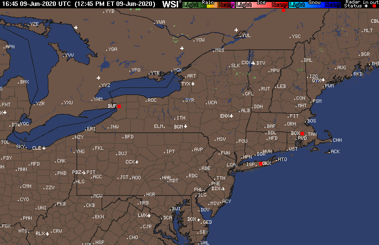
Sad to say the last of the precip is moving on out and I did not see a flake. Current temp is 34.6* I was up at 3am and 5am and rain it was out here on LI. Radar indicated it snowed down the the Ct Coast and got pretty close to the Jersey coast and NYC. I am sure at some point there may have been some flakes mixed in here and there overnight, but for the most part I didn't expect to see much out here on LI as the water temps are still in the 50's surrounding the island, my surface temp never got out of the mid thirties, and my current dew point is 34*(just not going to produce snow). If I had another 300-500ft elevation I prob would have had at least one to two inches on the ground as my rain gauge recorded 0.25" of QPF. But for those who are with me On LI or were along the coast line who were disappointed don't be. Im pretty sure LI did pretty well if not jack pot overall with total QPF, plus Its November 14th and water temps are going to do this to these types of systems this time of year. Keep that in mind for Mondays system as well. There is going to be even more influence to the R/S line with Mondays system because of the angle at which this system will be approaching the coast. There will be an easterly flow eroding the cold air in place in the mid layers and quickly push the R/S line much further inland compared to this system. Areas east of I-95 snow need not apply, however a quick hit of back end snow cannot be ruled out. Ill have more on this system in the other thread this weekend as my job schedule has got me tied up this week pretty bad. If this were late December Jan or Feb this system is all snow.
sroc4- Admin

- Posts : 8331
Join date : 2013-01-07
Re: November 14th Possible first flakes for some!!
![]() by Dunnzoo Fri Nov 14, 2014 6:49 am
by Dunnzoo Fri Nov 14, 2014 6:49 am
Was up til after midnight and didn't see much, had a tiny bit of a mix at times, but my surface temp was struggling to lower, was around 36-37* all night so it wasn't making it to the surface. 35.1* now...
Dunnzoo- Senior Enthusiast - Mod

- Posts : 4891
Join date : 2013-01-11
Re: November 14th Possible first flakes for some!!
![]() by Quietace Fri Nov 14, 2014 6:56 am
by Quietace Fri Nov 14, 2014 6:56 am
Dusting on cars. Snowed heavily for a few hours but that's what happens when you are above freezing and got to 50 the same day

Quietace- Meteorologist - Mod

- Posts : 3687
Reputation : 33
Join date : 2013-01-07
Age : 27
Location : Point Pleasant, NJ
Re: November 14th Possible first flakes for some!!
![]() by CPcantmeasuresnow Fri Nov 14, 2014 7:11 am
by CPcantmeasuresnow Fri Nov 14, 2014 7:11 am
docstox12 wrote:CPcantmeasuresnow wrote:docstox12 wrote:CP, radar looking pretty good, filling in more to the west.This baby is packing a bit of a punch.Maybe we can squeeze out two inches here.Passing out now, will report tomorrow AM early.
In One of the classic odd couple episodes where Felix has some kind of eye surgery and his ex Gloria takes care of him and Oscar for the weekend. You're my eyes Gloria.
Well Your my eyes Doc, no sleeping allowed.
As Jesus said to Peter and the other disciples when they fell asleep on watch after the last supper. The spirit is willing Doc but the flesh is weak.
LOL, verily I say unto ye, me flesh is weak at 64 years of age.However, you will be happy to note, 2 inches of snow fell in the HV last night.My first HV snow event.Great to have that 3 to 5 degree colder and elevation effect to help in borderline events like this xone.Real winter feel out there, snow covered ground and COLD.Maybe a slop event Sun-Mon up here.
Get back up here from Georgia.Don't go on any canoe trips in the backwoods unless you have Burt Reynolds and his bow and arrows!
Don't worry about me Doc, I'm a very cautious guy. If I do go on a canoe trips down here I'll make sure I have on my iron underwear.
Hate to miss the first snow of the season, my wife did send a picture of the backyard this morning, trees porch grass all covered with 2 inches of snow. Heartbreaking. As Frank stated last night I lost it for awhile there.
Thanks again.
Last edited by CPcantmeasuresnow on Fri Nov 14, 2014 7:19 am; edited 1 time in total

CPcantmeasuresnow- Wx Statistician Guru

- Posts : 7274
Reputation : 230
Join date : 2013-01-07
Age : 103
Location : Eastern Orange County, NY
Re: November 14th Possible first flakes for some!!
![]() by docstox12 Fri Nov 14, 2014 7:11 am
by docstox12 Fri Nov 14, 2014 7:11 am
Dunnzoo wrote:Was up til after midnight and didn't see much, had a tiny bit of a mix at times, but my surface temp was struggling to lower, was around 36-37* all night so it wasn't making it to the surface. 35.1* now...
Hey, Dunz, 2 inches here in Monroe HV. It was a typical Bergen County event in storms like this, a few wet flakes.

docstox12- Wx Statistician Guru
- Posts : 8504
Reputation : 222
Join date : 2013-01-07
Age : 73
Location : Monroe NY
Re: November 14th Possible first flakes for some!!
![]() by 2004blackwrx Fri Nov 14, 2014 7:19 am
by 2004blackwrx Fri Nov 14, 2014 7:19 am
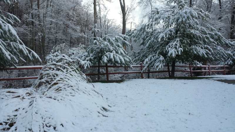
Drove home north on rt 9 from Buchanan in northern Westchester to Wappinger in Dutchess county. I didn't see any snow until outman and that was only in the big hill. As I got close to 301 More snow had stuck to all surfaces other then the road. I came home to 1.5 inches of snow. As seen below.Pretty exciting, just wish I got to see the snow falling. 
 " />
" />
" />
2004blackwrx- Pro Enthusiast

- Posts : 576
Reputation : 9
Join date : 2013-01-14
Location : Wappinger NY
Re: November 14th Possible first flakes for some!!
![]() by sroc4 Fri Nov 14, 2014 7:48 am
by sroc4 Fri Nov 14, 2014 7:48 am
2004blackwrx wrote:Drove home north on rt 9 from Buchanan in northern Westchester to Wappinger in Dutchess county. I didn't see any snow until outman and that was only in the big hill. As I got close to 301 More snow had stuck to all surfaces other then the road. I came home to 1.5 inches of snow. As seen below.Pretty exciting, just wish I got to see the snow falling.
Beautiful shot.
_________________
"In weather and in life, there's no winning and losing; there's only winning and learning."
WINTER 2012/2013 TOTALS 43.65"WINTER 2017/2018 TOTALS 62.85" WINTER 2022/2023 TOTALS 4.9"
WINTER 2013/2014 TOTALS 64.85"WINTER 2018/2019 TOTALS 14.25" WINTER 2023/2024 TOTALS 13.1"
WINTER 2014/2015 TOTALS 71.20"WINTER 2019/2020 TOTALS 6.35"
WINTER 2015/2016 TOTALS 35.00"WINTER 2020/2021 TOTALS 37.75"
WINTER 2016/2017 TOTALS 42.25"WINTER 2021/2022 TOTALS 31.65"

sroc4- Admin
- Posts : 8331
Reputation : 301
Join date : 2013-01-07
Location : Wading River, LI
Re: November 14th Possible first flakes for some!!
![]() by algae888 Fri Nov 14, 2014 7:57 am
by algae888 Fri Nov 14, 2014 7:57 am
jman on my way back home from fish market at 4am and got a 5-10 min. burst of snow. that was it for me.
scott I was at 35* and dp of 32* for a few hours and no snow. I couldn't believe it. the 850's and 925's were cold enough for snow and precip was moderate at times. I live about 5 miles inland from LI sound. in years past I have seen it snow in my area with temps in the mid 40's but I do not think it was November more like march. water temps in mid 50's was hard to overcome. I needed heavy precip which I did not get to draw down the cold air. I guess that's the main reason why we do not get many November snow storms near the coast. with this in mind I will not get to excited about Monday or any November snow threat in the future.
scott I was at 35* and dp of 32* for a few hours and no snow. I couldn't believe it. the 850's and 925's were cold enough for snow and precip was moderate at times. I live about 5 miles inland from LI sound. in years past I have seen it snow in my area with temps in the mid 40's but I do not think it was November more like march. water temps in mid 50's was hard to overcome. I needed heavy precip which I did not get to draw down the cold air. I guess that's the main reason why we do not get many November snow storms near the coast. with this in mind I will not get to excited about Monday or any November snow threat in the future.

algae888- Advanced Forecaster

- Posts : 5311
Reputation : 46
Join date : 2013-02-05
Age : 61
Location : mt. vernon, new york
Re: November 14th Possible first flakes for some!!
![]() by Dtone Fri Nov 14, 2014 8:49 am
by Dtone Fri Nov 14, 2014 8:49 am
Public Information Statement
Issued by NWS Upton, NY
PUBLIC INFORMATION STATEMENT
SPOTTER REPORTS
NATIONAL WEATHER SERVICE NEW YORK NY
824 AM EST FRI NOV 14 2014
THE FOLLOWING ARE UNOFFICIAL OBSERVATIONS TAKEN DURING THE PAST 24
HOURS FOR THE STORM THAT HAS BEEN AFFECTING OUR REGION. APPRECIATION
IS EXTENDED TO HIGHWAY DEPARTMENTS...COOPERATIVE OBSERVERS...SKYWARN
SPOTTERS AND MEDIA FOR THESE REPORTS. THIS SUMMARY IS ALSO AVAILABLE
ON OUR HOME PAGE AT WEATHER.GOV/NYC
********************STORM TOTAL SNOWFALL********************
LOCATION STORM TOTAL TIME/DATE COMMENTS
SNOWFALL OF
/INCHES/ MEASUREMENT
CONNECTICUT
...FAIRFIELD COUNTY...
NEWTOWN 2.1 600 AM 11/14 PUBLIC
...NEW HAVEN COUNTY...
WOLCOTT 3.2 445 AM 11/14 PUBLIC
NEW JERSEY
...PASSAIC COUNTY...
WEST MILFORD 2.2 1228 AM 11/14 PUBLIC
NEW YORK
...ORANGE COUNTY...
BLOOMING GROVE 2.0 754 AM 11/14 TRAINED SPOTTER
NEWBURGH 1.1 1130 PM 11/13 TRAINED SPOTTER
MONROE 1.0 737 AM 11/14 PUBLIC
NEW WINDSOR 1.0 730 AM 11/14 PUBLIC
**********************24 HOUR SNOWFALL**********************
LOCATION 24 HOUR TIME/DATE COMMENTS
SNOWFALL OF
/INCHES/ MEASUREMENT
CONNECTICUT
...FAIRFIELD COUNTY...
1 W SHELTON 0.4 600 AM 11/14 COCORAHS
...MIDDLESEX COUNTY...
1 S PORTLAND 0.5 800 AM 11/14 COCORAHS
NEW JERSEY
...UNION COUNTY...
1 ESE NEW PROVIDENCE 0.5 800 AM 11/14 COCORAHS
NEW YORK
...PUTNAM COUNTY...
4 ESE BEACON 1.0 620 AM 11/14 COCORAHS
...WESTCHESTER COUNTY...
2 NW SOUTH SALEM 0.3 730 AM 11/14 COCORAHS
E ARMONK 0.2 700 AM 11/14 COCORAHS
Dtone- Wx Statistician Guru
- Posts : 1738
Reputation : 9
Join date : 2013-08-26
Location : Bronx, NY
Re: November 14th Possible first flakes for some!!
![]() by sroc4 Fri Nov 14, 2014 9:03 am
by sroc4 Fri Nov 14, 2014 9:03 am
algae888 wrote:jman on my way back home from fish market at 4am and got a 5-10 min. burst of snow. that was it for me.
scott I was at 35* and dp of 32* for a few hours and no snow. I couldn't believe it. the 850's and 925's were cold enough for snow and precip was moderate at times. I live about 5 miles inland from LI sound. in years past I have seen it snow in my area with temps in the mid 40's but I do not think it was November more like march. water temps in mid 50's was hard to overcome. I needed heavy precip which I did not get to draw down the cold air. I guess that's the main reason why we do not get many November snow storms near the coast. with this in mind I will not get to excited about Monday or any November snow threat in the future.
Al you cannot get surface temps below the dew point value. The evaporative cooling effects to the column can usually only get the surface temp as low as the avg between the two. There are other factors however, that influence the dynamic cooling. Its not quite as easy as the simple avg, and I don't fully understand all the different things that can affect it, but in our case the warm surface temps over the waters compared to over land Im sure played a big part. Also with the surface temp and dew points so close there really wasn't a whole lot of cooling degrees that could occur throughout the column vs if they were further apart; ie: surface temp 38* and dew point 32*. (1.5 cooling degrees vs 3 cooling degrees respectively)
For example. 925mb is still approx. 2500feet above sea level. Lets assume the temps at that level last night were 25*. The 32* line didn't start until you dropped to 1500ft. So as the snow flake passes the 1500foot level it will start to melt. As it starts to melt there will be some evaporation to the liquid back into the atmosphere as long as dew point is lower than air temps. As we know evaporation has a cooling effect to the air around it. That's why we sweat; so that evaporation cools the surface of our skin. So using your surface temp(ST) and your dew point (DP) for this example, if we used the rule of the avg there are only 1.5 cooling degrees that can occur in the atmosphere (DP=32* + ST=35*)/ 2 =33.5* A difference of 1.5* between the surface temp (35*) and the avg temp between the DP and ST(33.5).
33.5* is the coldest the air can get from evaporative cooling with your numbers. So your surface temp can only go from 35* to 33.5* a difference of 1.5*. Now lets say that because the water temps are so warm(mid to upper 50's in most areas around us right now) that from the surface up to 1000ft the temps are around 35*,and the temps between 1000ft and 1500ft go from 35*-32* (because we said above that 1500ft was as low as the freezing line got. So basically if we subtract 1.5* cooling degrees to the first 1000ft of altitude we never get above freezing (35*-1.5*=32.5). Its only when you get above that that we are cooling the atmosphere down to freezing with the dynamic cooling effect. Snow flake now has to travel through 1000ft of above freezing temps.
However; if you take your surface temp up to 38* but keep your same DP at 32* you now get an avg of 35*. So your ST can drop only as low as 35* a difference of 3* cooling degrees vs 1.5* cooling degrees in the first example (38* ST - 33* after evap cooling). If all the other numbers stayed the same except that the surface layer at 38* only went up 500ft, and between 500ft and 1000ft was 35* then if you dropped three degrees from dynamic cooling you can get freezing temps down to 500ft of elevation(35*-33*=32* vs 1000ft of elevation in the first example. Therefore; the snow flake has to travel through 500ft less of above freezing temps in the second example compared to the first.
I hope that makes sense but ultimately that is why I think the immediate coast saw what they saw. Ive read that you only need about 100ft of elevation (it may have been meters) to change from a full snowflake to rain. Examples of that are seen on mountain sides where you get the abrupt snow lines.
_________________
"In weather and in life, there's no winning and losing; there's only winning and learning."
WINTER 2012/2013 TOTALS 43.65"WINTER 2017/2018 TOTALS 62.85" WINTER 2022/2023 TOTALS 4.9"
WINTER 2013/2014 TOTALS 64.85"WINTER 2018/2019 TOTALS 14.25" WINTER 2023/2024 TOTALS 13.1"
WINTER 2014/2015 TOTALS 71.20"WINTER 2019/2020 TOTALS 6.35"
WINTER 2015/2016 TOTALS 35.00"WINTER 2020/2021 TOTALS 37.75"
WINTER 2016/2017 TOTALS 42.25"WINTER 2021/2022 TOTALS 31.65"
sroc4- Admin
- Posts : 8331
Reputation : 301
Join date : 2013-01-07
Location : Wading River, LI
Re: November 14th Possible first flakes for some!!
![]() by Frank_Wx Fri Nov 14, 2014 9:45 am
by Frank_Wx Fri Nov 14, 2014 9:45 am
2004blackwrx wrote:Drove home north on rt 9 from Buchanan in northern Westchester to Wappinger in Dutchess county. I didn't see any snow until outman and that was only in the big hill. As I got close to 301 More snow had stuck to all surfaces other then the road. I came home to 1.5 inches of snow. As seen below.Pretty exciting, just wish I got to see the snow falling.
So nice
_________________
_______________________________________________________________________________________________________
CLICK HERE to view NJ Strong Snowstorm Classifications

Frank_Wx- Godzilla Seeker
- Posts : 21305
Reputation : 328
Join date : 2013-01-05
Age : 31
Location : Jersey City, NJ -

Re: November 14th Possible first flakes for some!!
![]() by algae888 Fri Nov 14, 2014 10:41 am
by algae888 Fri Nov 14, 2014 10:41 am
scott I think I understand. I know it has snowed before with those #'s.(35* DP32*). so in this example for it to snow the 35* surface temp had to be right at the surface maybe 100ft or less
and that last night 35* temp had to extent up in the atmosphere about 500 ft or more. am I right? tks for replying
and that last night 35* temp had to extent up in the atmosphere about 500 ft or more. am I right? tks for replying
algae888- Advanced Forecaster
- Posts : 5311
Reputation : 46
Join date : 2013-02-05
Age : 61
Location : mt. vernon, new york
Re: November 14th Possible first flakes for some!!
![]() by sroc4 Fri Nov 14, 2014 12:17 pm
by sroc4 Fri Nov 14, 2014 12:17 pm
algae888 wrote:scott I think I understand. I know it has snowed before with those #'s.(35* DP32*). so in this example for it to snow the 35* surface temp had to be right at the surface maybe 100ft or less
and that last night 35* temp had to extent up in the atmosphere about 500 ft or more. am I right? tks for replying
Yeah my guess is that the snow had to travel through too big of an area above freezing even though it would appear just above. What the actual depth was is anyone's guess. Since the 925mb layer (approx 2500ft) was below freezing it was somewhere below that. Plus since you said you really weren't in the heavier bands its possible the dynamic effects didn't even cool to the avg of 1.5 cooling degrees. Who knows. Its all theory from my part but does make scientific sense esp with such warm water temps along the coast right now.
_________________
"In weather and in life, there's no winning and losing; there's only winning and learning."
WINTER 2012/2013 TOTALS 43.65"WINTER 2017/2018 TOTALS 62.85" WINTER 2022/2023 TOTALS 4.9"
WINTER 2013/2014 TOTALS 64.85"WINTER 2018/2019 TOTALS 14.25" WINTER 2023/2024 TOTALS 13.1"
WINTER 2014/2015 TOTALS 71.20"WINTER 2019/2020 TOTALS 6.35"
WINTER 2015/2016 TOTALS 35.00"WINTER 2020/2021 TOTALS 37.75"
WINTER 2016/2017 TOTALS 42.25"WINTER 2021/2022 TOTALS 31.65"
sroc4- Admin
- Posts : 8331
Reputation : 301
Join date : 2013-01-07
Location : Wading River, LI
Re: November 14th Possible first flakes for some!!
![]() by docstox12 Sat Nov 15, 2014 5:43 am
by docstox12 Sat Nov 15, 2014 5:43 am
CPcantmeasuresnow wrote:docstox12 wrote:CPcantmeasuresnow wrote:docstox12 wrote:CP, radar looking pretty good, filling in more to the west.This baby is packing a bit of a punch.Maybe we can squeeze out two inches here.Passing out now, will report tomorrow AM early.
In One of the classic odd couple episodes where Felix has some kind of eye surgery and his ex Gloria takes care of him and Oscar for the weekend. You're my eyes Gloria.
Well Your my eyes Doc, no sleeping allowed.
As Jesus said to Peter and the other disciples when they fell asleep on watch after the last supper. The spirit is willing Doc but the flesh is weak.
LOL, verily I say unto ye, me flesh is weak at 64 years of age.However, you will be happy to note, 2 inches of snow fell in the HV last night.My first HV snow event.Great to have that 3 to 5 degree colder and elevation effect to help in borderline events like this xone.Real winter feel out there, snow covered ground and COLD.Maybe a slop event Sun-Mon up here.
Get back up here from Georgia.Don't go on any canoe trips in the backwoods unless you have Burt Reynolds and his bow and arrows!
Don't worry about me Doc, I'm a very cautious guy. If I do go on a canoe trips down here I'll make sure I have on my iron underwear.
Hate to miss the first snow of the season, my wife did send a picture of the backyard this morning, trees porch grass all covered with 2 inches of snow. Heartbreaking. As Frank stated last night I lost it for awhile there.
Thanks again.
CP, I can see why you get angry at these guys who measure snow.The "official" total in Monroe NY was one inch but I measured two.Maybe he was at a lower location.I drove down the pike past the Red Apple Rest and they just had a dusting while up here near the top of the Orange Turnpike I got two.
docstox12- Wx Statistician Guru
- Posts : 8504
Reputation : 222
Join date : 2013-01-07
Age : 73
Location : Monroe NY
Page 8 of 8 • 1, 2, 3, 4, 5, 6, 7, 8
Permissions in this forum:
You cannot reply to topics in this forum|
|
|