
 Search
Possible Nor'easter Dec. 9th-10th
Page 15 of 20 •  1 ... 9 ... 14, 15, 16 ... 20
 ![]()
Re: Possible Nor'easter Dec. 9th-10th
![]() by jmanley32 Sun Dec 07, 2014 10:58 am
by jmanley32 Sun Dec 07, 2014 10:58 am
jmanley32- Senior Enthusiast

- Posts : 20517
Join date : 2013-12-12
Re: Possible Nor'easter Dec. 9th-10th
![]() by CPcantmeasuresnow Sun Dec 07, 2014 12:21 pm
by CPcantmeasuresnow Sun Dec 07, 2014 12:21 pm
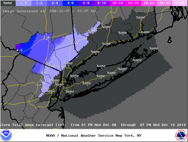
jmanley32 wrote:NWs first snow map, everything to the north as of now.
Interesting map for Orange County, 1-2 inches on the southern border and 8-10 inches in the extreme northwest portion. I doubt that will verify one way or the other, but I guess it's as good a first guess as any here. It also doesn't include anything for possible Thursday retrograde.
There's still so much to iron out this week.
CPcantmeasuresnow- Wx Statistician Guru

- Posts : 7274
Join date : 2013-01-07
Re: Possible Nor'easter Dec. 9th-10th
![]() by aiannone Sun Dec 07, 2014 12:28 pm
by aiannone Sun Dec 07, 2014 12:28 pm
_________________
-Alex Iannone-

aiannone- Senior Enthusiast - Mod

- Posts : 4814
Reputation : 92
Join date : 2013-01-07
Location : Saint James, LI (Northwest Suffolk Co.)
Re: Possible Nor'easter Dec. 9th-10th
![]() by aiannone Sun Dec 07, 2014 12:37 pm
by aiannone Sun Dec 07, 2014 12:37 pm

_________________
-Alex Iannone-
aiannone- Senior Enthusiast - Mod
- Posts : 4814
Reputation : 92
Join date : 2013-01-07
Location : Saint James, LI (Northwest Suffolk Co.)
Re: Possible Nor'easter Dec. 9th-10th
![]() by jmanley32 Sun Dec 07, 2014 12:45 pm
by jmanley32 Sun Dec 07, 2014 12:45 pm

jmanley32- Senior Enthusiast
- Posts : 20517
Reputation : 108
Join date : 2013-12-12
Age : 42
Location : Yonkers, NY
Re: Possible Nor'easter Dec. 9th-10th
![]() by rb924119 Sun Dec 07, 2014 1:08 pm
by rb924119 Sun Dec 07, 2014 1:08 pm
rb924119- Meteorologist

- Posts : 6890
Reputation : 194
Join date : 2013-02-06
Age : 32
Location : Greentown, Pa
Re: Possible Nor'easter Dec. 9th-10th
![]() by aiannone Sun Dec 07, 2014 1:09 pm
by aiannone Sun Dec 07, 2014 1:09 pm
_________________
-Alex Iannone-
aiannone- Senior Enthusiast - Mod
- Posts : 4814
Reputation : 92
Join date : 2013-01-07
Location : Saint James, LI (Northwest Suffolk Co.)
Re: Possible Nor'easter Dec. 9th-10th
![]() by CPcantmeasuresnow Sun Dec 07, 2014 1:15 pm
by CPcantmeasuresnow Sun Dec 07, 2014 1:15 pm

CPcantmeasuresnow- Wx Statistician Guru
- Posts : 7274
Reputation : 230
Join date : 2013-01-07
Age : 103
Location : Eastern Orange County, NY
Re: Possible Nor'easter Dec. 9th-10th
![]() by algae888 Sun Dec 07, 2014 1:19 pm
by algae888 Sun Dec 07, 2014 1:19 pm

algae888- Advanced Forecaster

- Posts : 5311
Reputation : 46
Join date : 2013-02-05
Age : 61
Location : mt. vernon, new york
Re: Possible Nor'easter Dec. 9th-10th
![]() by rb924119 Sun Dec 07, 2014 1:22 pm
by rb924119 Sun Dec 07, 2014 1:22 pm
rb924119- Meteorologist
- Posts : 6890
Reputation : 194
Join date : 2013-02-06
Age : 32
Location : Greentown, Pa
Re: Possible Nor'easter Dec. 9th-10th
![]() by mancave25 Sun Dec 07, 2014 1:23 pm
by mancave25 Sun Dec 07, 2014 1:23 pm
mancave25- Posts : 112
Reputation : 0
Join date : 2014-02-05
Re: Possible Nor'easter Dec. 9th-10th
![]() by jmanley32 Sun Dec 07, 2014 1:31 pm
by jmanley32 Sun Dec 07, 2014 1:31 pm
jmanley32- Senior Enthusiast
- Posts : 20517
Reputation : 108
Join date : 2013-12-12
Age : 42
Location : Yonkers, NY
Re: Possible Nor'easter Dec. 9th-10th
![]() by jmanley32 Sun Dec 07, 2014 2:09 pm
by jmanley32 Sun Dec 07, 2014 2:09 pm
jmanley32- Senior Enthusiast
- Posts : 20517
Reputation : 108
Join date : 2013-12-12
Age : 42
Location : Yonkers, NY
Re: Possible Nor'easter Dec. 9th-10th
![]() by jmanley32 Sun Dec 07, 2014 2:13 pm
by jmanley32 Sun Dec 07, 2014 2:13 pm
jmanley32- Senior Enthusiast
- Posts : 20517
Reputation : 108
Join date : 2013-12-12
Age : 42
Location : Yonkers, NY
Re: Possible Nor'easter Dec. 9th-10th
![]() by rb924119 Sun Dec 07, 2014 2:14 pm
by rb924119 Sun Dec 07, 2014 2:14 pm
rb924119- Meteorologist
- Posts : 6890
Reputation : 194
Join date : 2013-02-06
Age : 32
Location : Greentown, Pa
Re: Possible Nor'easter Dec. 9th-10th
![]() by jmanley32 Sun Dec 07, 2014 2:17 pm
by jmanley32 Sun Dec 07, 2014 2:17 pm
jmanley32- Senior Enthusiast
- Posts : 20517
Reputation : 108
Join date : 2013-12-12
Age : 42
Location : Yonkers, NY
Re: Possible Nor'easter Dec. 9th-10th
![]() by jmanley32 Sun Dec 07, 2014 2:19 pm
by jmanley32 Sun Dec 07, 2014 2:19 pm
jmanley32- Senior Enthusiast
- Posts : 20517
Reputation : 108
Join date : 2013-12-12
Age : 42
Location : Yonkers, NY
Re: Possible Nor'easter Dec. 9th-10th
![]() by jmanley32 Sun Dec 07, 2014 2:26 pm
by jmanley32 Sun Dec 07, 2014 2:26 pm
jmanley32- Senior Enthusiast
- Posts : 20517
Reputation : 108
Join date : 2013-12-12
Age : 42
Location : Yonkers, NY
Re: Possible Nor'easter Dec. 9th-10th
![]() by jmanley32 Sun Dec 07, 2014 2:51 pm
by jmanley32 Sun Dec 07, 2014 2:51 pm
http://www.accuweather.com/en/weather-video/midweek-storm-to-blast-northeast/3901417444001
jmanley32- Senior Enthusiast
- Posts : 20517
Reputation : 108
Join date : 2013-12-12
Age : 42
Location : Yonkers, NY
Re: Possible Nor'easter Dec. 9th-10th
![]() by rb924119 Sun Dec 07, 2014 3:17 pm
by rb924119 Sun Dec 07, 2014 3:17 pm
rb924119- Meteorologist
- Posts : 6890
Reputation : 194
Join date : 2013-02-06
Age : 32
Location : Greentown, Pa
Re: Possible Nor'easter Dec. 9th-10th
![]() by rb924119 Sun Dec 07, 2014 3:32 pm
by rb924119 Sun Dec 07, 2014 3:32 pm
rb924119- Meteorologist
- Posts : 6890
Reputation : 194
Join date : 2013-02-06
Age : 32
Location : Greentown, Pa
Re: Possible Nor'easter Dec. 9th-10th
![]() by docstox12 Sun Dec 07, 2014 3:39 pm
by docstox12 Sun Dec 07, 2014 3:39 pm

docstox12- Wx Statistician Guru
- Posts : 8507
Reputation : 222
Join date : 2013-01-07
Age : 73
Location : Monroe NY
Re: Possible Nor'easter Dec. 9th-10th
![]() by rb924119 Sun Dec 07, 2014 3:40 pm
by rb924119 Sun Dec 07, 2014 3:40 pm
rb924119- Meteorologist
- Posts : 6890
Reputation : 194
Join date : 2013-02-06
Age : 32
Location : Greentown, Pa
Re: Possible Nor'easter Dec. 9th-10th
![]() by jmanley32 Sun Dec 07, 2014 3:41 pm
by jmanley32 Sun Dec 07, 2014 3:41 pm
jmanley32- Senior Enthusiast
- Posts : 20517
Reputation : 108
Join date : 2013-12-12
Age : 42
Location : Yonkers, NY
Re: Possible Nor'easter Dec. 9th-10th
![]() by jmanley32 Sun Dec 07, 2014 3:43 pm
by jmanley32 Sun Dec 07, 2014 3:43 pm
jmanley32- Senior Enthusiast
- Posts : 20517
Reputation : 108
Join date : 2013-12-12
Age : 42
Location : Yonkers, NY
Re: Possible Nor'easter Dec. 9th-10th
![]() by jmanley32 Sun Dec 07, 2014 3:44 pm
by jmanley32 Sun Dec 07, 2014 3:44 pm
jmanley32- Senior Enthusiast
- Posts : 20517
Reputation : 108
Join date : 2013-12-12
Age : 42
Location : Yonkers, NY
Re: Possible Nor'easter Dec. 9th-10th
![]() by leimatt95 Sun Dec 07, 2014 3:46 pm
by leimatt95 Sun Dec 07, 2014 3:46 pm
MORNING...
THE NATIONAL WEATHER SERVICE IN BINGHAMTON HAS ISSUED A WINTER
STORM WATCH...WHICH IS IN EFFECT FROM LATE MONDAY NIGHT THROUGH
WEDNESDAY MORNING.
* LOCATIONS...PORTIONS OF CENTRAL NEW YORK AND NORTHEAST PENNSYLVANIA.
* HAZARDS...HEAVY SNOW.
* ACCUMULATIONS...7 INCHES OR MORE OF SNOW IS POSSIBLE.
* TIMING...MIXED PRECIPITATION WILL OVERSPREAD THE AREA LATE
MONDAY NIGHT THROUGH TUESDAY MORNING. MIXED PRECIPITATION WILL
BECOME ALL SNOW TUESDAY NIGHT WITH HEAVY ACCUMULATIONS POSSIBLE.
OCCASIONAL SNOW OR SNOW SHOWERS WILL PERSIST THROUGH WEDNESDAY
AND THURSDAY WITH LIGHTER ACCUMULATIONS LIKELY.
* TEMPERATURES...MAINLY BETWEEN 30 AND 35.
* WINDS...NORTHEAST 10 TO 15 MPH INCREASING TO 10 TO 20 MPH
TUESDAY NIGHT.
* IMPACTS...A MIX OF RAIN... SNOW... AND POSSIBLY SOME FREEZING
RAIN WILL OVERSPREAD THE AREA FROM SOUTH TO NORTH LATE MONDAY
NIGHT THROUGH TUESDAY MORNING. PRECIPITATION WILL BE MIXED
THROUGH THE DAY TUESDAY... CHANGING TO ALL SNOW TUESDAY NIGHT.
ACCUMULATIONS OF 7 INCHES OR MORE IS POSSIBLE. HAZARDOUS TRAVEL
WILL BE POSSIBLE WITH THE MIXED PRECIPITATION ON TUESDAY...
HOWEVER THE WORST CONDITIONS MAY BE ON TUESDAY NIGHT WITH
HEAVIER SNOW FALLING.
leimatt95- Posts : 14
Reputation : 0
Join date : 2013-10-31
Page 15 of 20 • 1 ... 9 ... 14, 15, 16 ... 20 ![]()
|
|
|