
 Search
Update #2: EURO Brings The Heat, Same Ol' GFS? (1/24/15)
Page 1 of 11 • 1, 2, 3 ... 9, 10, 11 ![]()

Update #2: EURO Brings The Heat, Same Ol' GFS? (1/24/15)
![]() by Frank_Wx Wed Jan 21, 2015 7:24 pm
by Frank_Wx Wed Jan 21, 2015 7:24 pm
12z EURO Model
The EURO brings The Heat:

Whoops, my bad. That's the wrong context. Meant to show this:
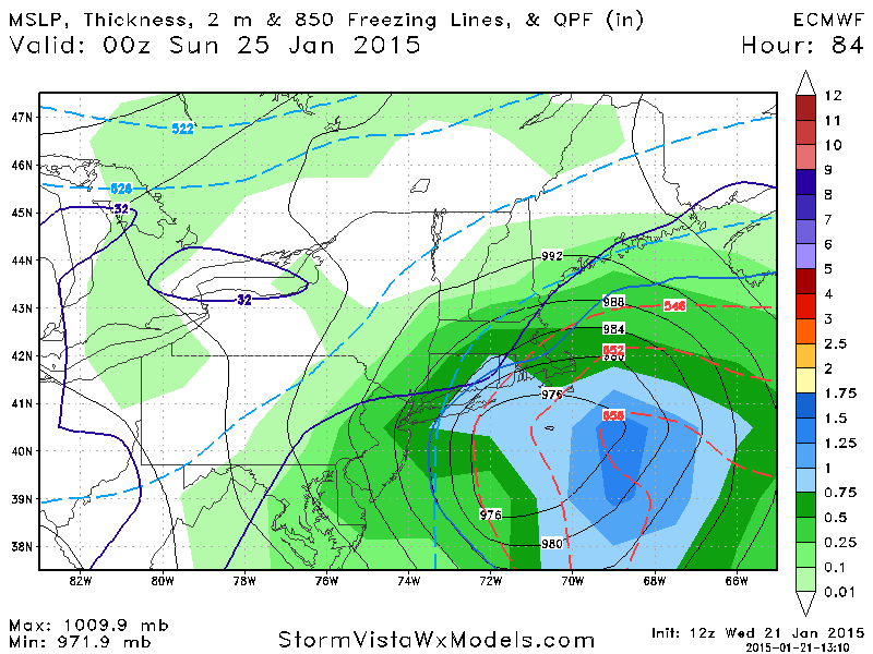
There is your glorified 972mb low just inside the BM bringing a swath of 12+ inch snows from Philly to Boston and 6-12 inches NW of I-95. Lets check out what the EURO did today with the upper air configuration
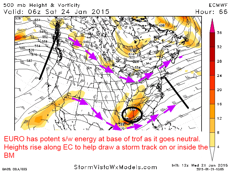
This image depicts early Saturday morning. The purple arrows represent the northern and southern jet streams. I think you're all knowledgeable enough to know which one is which. There's a nice western ridge pushing ashore with a sharp-looking trough over the southeastern U.S. Notice how the H5 energy is nice and compact near the base of the mid-level trough. Thus, heights along the EC are able to rise and allow the H5 energy to take a track up the coast off of NJ.

Forward to Saturday afternoon, now you have a closed off H5 low south of Long Island. The northern and southern branches have phased and bombogenesis is taking place. An all out blizzard / Godzilla is impacting the area as dynamic cooling comes into play. Even though there is not much northern stream interaction, the potency of the southern stream is enough to develop a strong system.
12z GFS Model
I say same ol' GFS because remember this model got upgraded not too long ago. However, I still feel like its typical progressive bias is still showing (the same bias the old GFS model had).

Iv'e seen a lot of comments basically dismissing this run of the GFS, but honestly it's not like it lost the storm. It's very much there and even bombs out just like the EURO. The track is east of the BM, however, so many are left with a glancing blow.

Here you see the GFS on Saturday morning. Look at the energy within the mid-level trough. It's very elongated along the eastern quadrant. This means we have a progressive trough tracking east with flat heights along the east coast. The energy is still strong, so a storm does form, but we want to see the southern s/w energy be consolidated at the base of the trough.

By Saturday afternoon the GFS manages to phase both jet streams but it occurs too late for our area to see a meaningful storm. I sincerely think the GFS is not handling the southern stream s/w correctly. It's trying to scoot it ahead of the trough instead of capturing it and harnessing it. This will obviously effect how it tracks the storm. Don't get me wrong, we have been in a progressive pattern so its solution is not totally out of left field, but give how its ensembles look and the other foreign models...I have a hard time believing it right now. BUT, its solution remains a possibility as much as no one likes to hear that.
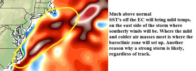
One other thing to consider are the sea surface temp. anomalies off the coast. They are running much above normal. This is going to help fuel the storm some more, and in my opinion, promote a track closer to the coast. I'm not thinking right along the coast...but a track on or just inside the BM is what my heart is telling me right now. Where the northwesterly and south-southeasterly winds meet is where the baroclinic zone is likely to set up. Bombogenesis is most certainly to occur with this system, regardless of where it tracks.
Confidence:
Hit- 70%
Out to sea- 30%
Timing:
Early Saturday morning until early Saturday evening
Stay tuned, Update #3 around same time tomorrow!
_________________
_______________________________________________________________________________________________________
CLICK HERE to view NJ Strong Snowstorm Classifications

Frank_Wx- Godzilla Seeker

- Posts : 21305
Reputation : 328
Join date : 2013-01-05
Age : 31
Location : Jersey City, NJ -

Re: Update #2: EURO Brings The Heat, Same Ol' GFS? (1/24/15)
![]() by SoulSingMG Wed Jan 21, 2015 7:32 pm
by SoulSingMG Wed Jan 21, 2015 7:32 pm


SoulSingMG- Senior Enthusiast

- Posts : 2853
Reputation : 74
Join date : 2013-12-11
Location : Long Island City, NY
Re: Update #2: EURO Brings The Heat, Same Ol' GFS? (1/24/15)
![]() by RJB8525 Wed Jan 21, 2015 7:38 pm
by RJB8525 Wed Jan 21, 2015 7:38 pm
He(can't remember his name he's on all the time) then moved onto the Northeast and giving EURO and GFS models. he talked about the comparasions about differences but said all ensembles are leading towards the Euro and basically said could be a very big snow event for the north east

RJB8525- Senior Enthusiast
- Posts : 1994
Reputation : 28
Join date : 2013-02-06
Age : 38
Location : Hackettstown, NJ
Re: Update #2: EURO Brings The Heat, Same Ol' GFS? (1/24/15)
![]() by jmanley32 Wed Jan 21, 2015 7:40 pm
by jmanley32 Wed Jan 21, 2015 7:40 pm

jmanley32- Senior Enthusiast
- Posts : 20516
Reputation : 108
Join date : 2013-12-12
Age : 42
Location : Yonkers, NY
Re: Update #2: EURO Brings The Heat, Same Ol' GFS? (1/24/15)
![]() by aiannone Wed Jan 21, 2015 7:43 pm
by aiannone Wed Jan 21, 2015 7:43 pm
_________________
-Alex Iannone-

aiannone- Senior Enthusiast - Mod

- Posts : 4813
Reputation : 92
Join date : 2013-01-07
Location : Saint James, LI (Northwest Suffolk Co.)
Re: Update #2: EURO Brings The Heat, Same Ol' GFS? (1/24/15)
![]() by rb924119 Wed Jan 21, 2015 7:49 pm
by rb924119 Wed Jan 21, 2015 7:49 pm
aiannone wrote:I cannot believe I am going to miss this storm. I waited all winter break for a storm on the coast and now I leave and literally 4 days after a major nor'easter is awaiting. FML......
You think that's bad.....
I have lived in NE PA my entire 23 years on this planet, and NOT ONCE have I ever experienced thundersnow. The first year that I left for school, that winter my parents had it here at the house twice; TWICE!!!! I came home for the big February storm last winter highly confident that I would see it then, and there were reports of it in Sussex, NJ, which is the next county east of me, but it never crossed the Delaware River. I never saw it at school my entire undergraduate career and I just graduated this past May. First major winter storm they got up there this season- THUNDERSNOW LIKE CRAZY. I was so mad. lmao talk about slaps in the face ahahaha
rb924119- Meteorologist

- Posts : 6890
Reputation : 194
Join date : 2013-02-06
Age : 32
Location : Greentown, Pa
Re: Update #2: EURO Brings The Heat, Same Ol' GFS? (1/24/15)
![]() by Guest Wed Jan 21, 2015 7:59 pm
by Guest Wed Jan 21, 2015 7:59 pm
Guest- Guest
Re: Update #2: EURO Brings The Heat, Same Ol' GFS? (1/24/15)
![]() by oldtimer Wed Jan 21, 2015 7:59 pm
by oldtimer Wed Jan 21, 2015 7:59 pm
oldtimer- Senior Enthusiast
- Posts : 1103
Reputation : 14
Join date : 2013-01-16
Age : 78
Location : Port Jefferson Station Suffolk County
Re: Update #2: EURO Brings The Heat, Same Ol' GFS? (1/24/15)
![]() by devsman Wed Jan 21, 2015 8:00 pm
by devsman Wed Jan 21, 2015 8:00 pm
But Jman, love those LI ice teas. Nothing gets you going like one of those. OK, 5 of those. But you understand.
I'm hoping Euro verifies. This will be a fun convo friday night if this comes to fruition. I miss those late nights with the gang.

devsman- Pro Enthusiast

- Posts : 424
Reputation : 4
Join date : 2014-01-01
Age : 48
Location : merrick, ny (south shore of Long Island)
Re: Update #2: EURO Brings The Heat, Same Ol' GFS? (1/24/15)
![]() by Analog96 Wed Jan 21, 2015 8:04 pm
by Analog96 Wed Jan 21, 2015 8:04 pm
And it comes on a Friday night, so we don't have to work the next day (most of us).devsman wrote:I want to go back to the fridays vs. chili convo. lol. Just kidding.
But Jman, love those LI ice teas. Nothing gets you going like one of those. OK, 5 of those. But you understand.
I'm hoping Euro verifies. This will be a fun convo friday night if this comes to fruition. I miss those late nights with the gang.
Analog96- Meteorologist
- Posts : 156
Reputation : 1
Join date : 2014-03-12
Location : Elizabeth, NJ
Re: Update #2: EURO Brings The Heat, Same Ol' GFS? (1/24/15)
![]() by Math23x7 Wed Jan 21, 2015 8:05 pm
by Math23x7 Wed Jan 21, 2015 8:05 pm
Math23x7- Wx Statistician Guru

- Posts : 2379
Reputation : 68
Join date : 2013-01-08
Re: Update #2: EURO Brings The Heat, Same Ol' GFS? (1/24/15)
![]() by Quietace Wed Jan 21, 2015 8:07 pm
by Quietace Wed Jan 21, 2015 8:07 pm
I got 9am-10pm both Saturday and Sunday...Math23x7 wrote:Analog96, I work Saturday from 7 AM to 1 PM...

Quietace- Meteorologist - Mod

- Posts : 3687
Reputation : 33
Join date : 2013-01-07
Age : 27
Location : Point Pleasant, NJ
Re: Update #2: EURO Brings The Heat, Same Ol' GFS? (1/24/15)
![]() by mako460 Wed Jan 21, 2015 8:10 pm
by mako460 Wed Jan 21, 2015 8:10 pm
mako460- Pro Enthusiast
- Posts : 346
Reputation : 4
Join date : 2013-01-09
Age : 57
Location : Gerritsen Beach Brooklyn
Re: Update #2: EURO Brings The Heat, Same Ol' GFS? (1/24/15)
![]() by Philliesfan Wed Jan 21, 2015 8:13 pm
by Philliesfan Wed Jan 21, 2015 8:13 pm
Philliesfan- Posts : 24
Reputation : 0
Join date : 2013-12-13
Location : Ridgewood NJ
Re: Update #2: EURO Brings The Heat, Same Ol' GFS? (1/24/15)
![]() by nutleyblizzard Wed Jan 21, 2015 8:17 pm
by nutleyblizzard Wed Jan 21, 2015 8:17 pm

nutleyblizzard- Senior Enthusiast
- Posts : 1952
Reputation : 41
Join date : 2014-01-30
Age : 58
Location : Nutley, new jersey
Re: Update #2: EURO Brings The Heat, Same Ol' GFS? (1/24/15)
![]() by oldtimer Wed Jan 21, 2015 8:23 pm
by oldtimer Wed Jan 21, 2015 8:23 pm
oldtimer- Senior Enthusiast
- Posts : 1103
Reputation : 14
Join date : 2013-01-16
Age : 78
Location : Port Jefferson Station Suffolk County
Re: Update #2: EURO Brings The Heat, Same Ol' GFS? (1/24/15)
![]() by LB3147 Wed Jan 21, 2015 8:25 pm
by LB3147 Wed Jan 21, 2015 8:25 pm
rb924119 wrote:aiannone wrote:I cannot believe I am going to miss this storm. I waited all winter break for a storm on the coast and now I leave and literally 4 days after a major nor'easter is awaiting. FML......
You think that's bad.....
I have lived in NE PA my entire 23 years on this planet, and NOT ONCE have I ever experienced thundersnow. The first year that I left for school, that winter my parents had it here at the house twice; TWICE!!!! I came home for the big February storm last winter highly confident that I would see it then, and there were reports of it in Sussex, NJ, which is the next county east of me, but it never crossed the Delaware River. I never saw it at school my entire undergraduate career and I just graduated this past May. First major winter storm they got up there this season- THUNDERSNOW LIKE CRAZY. I was so mad. lmao talk about slaps in the face ahahaha
RB....I'm lucky enough to have experienced thundersnow twice....once as a kid in Monmouth County during the March '93 Blizzard.....and the second time walking out of a bar in Manhattan, Brother Jimmy's to be exact, during the 2010 December Blizzard....remember seeing bolt of blue colored lightning followed by a boom of thunder the minute we walked out, was scary......I just remember thinking during both storms, that these weren't nice fun snows....both were mean SOB's
Last edited by LB3147 on Wed Jan 21, 2015 8:26 pm; edited 1 time in total (Reason for editing : spelling)
LB3147- Posts : 31
Reputation : 0
Join date : 2014-11-11
Re: Update #2: EURO Brings The Heat, Same Ol' GFS? (1/24/15)
![]() by rb924119 Wed Jan 21, 2015 8:33 pm
by rb924119 Wed Jan 21, 2015 8:33 pm
LB3147 wrote:rb924119 wrote:aiannone wrote:I cannot believe I am going to miss this storm. I waited all winter break for a storm on the coast and now I leave and literally 4 days after a major nor'easter is awaiting. FML......
You think that's bad.....
I have lived in NE PA my entire 23 years on this planet, and NOT ONCE have I ever experienced thundersnow. The first year that I left for school, that winter my parents had it here at the house twice; TWICE!!!! I came home for the big February storm last winter highly confident that I would see it then, and there were reports of it in Sussex, NJ, which is the next county east of me, but it never crossed the Delaware River. I never saw it at school my entire undergraduate career and I just graduated this past May. First major winter storm they got up there this season- THUNDERSNOW LIKE CRAZY. I was so mad. lmao talk about slaps in the face ahahaha
RB....I'm lucky enough to have experienced thundersnow twice....once as a kid in Monmouth County during the March '93 Blizzard.....and the second time walking out of a bar in Manhattan, Brother Jimmy's to be exact, during the 2010 December Blizzard....remember seeing bolt of blue colored lightning followed by a boom of thunder the minute we walked out, was scary......I just remember thinking during both storms, that these weren't nice fun snows....both were mean SOB's
Wowwwww, that's so cool!!! I'm so jealous!!! I would give just about anything to witness it in person
rb924119- Meteorologist
- Posts : 6890
Reputation : 194
Join date : 2013-02-06
Age : 32
Location : Greentown, Pa
Re: Update #2: EURO Brings The Heat, Same Ol' GFS? (1/24/15)
![]() by Analog96 Wed Jan 21, 2015 8:35 pm
by Analog96 Wed Jan 21, 2015 8:35 pm
Analog96- Meteorologist
- Posts : 156
Reputation : 1
Join date : 2014-03-12
Location : Elizabeth, NJ
Re: Update #2: EURO Brings The Heat, Same Ol' GFS? (1/24/15)
![]() by devsman Wed Jan 21, 2015 8:36 pm
by devsman Wed Jan 21, 2015 8:36 pm
Analog96 wrote:And it comes on a Friday night, so we don't have to work the next day (most of us).devsman wrote:I want to go back to the fridays vs. chili convo. lol. Just kidding.
But Jman, love those LI ice teas. Nothing gets you going like one of those. OK, 5 of those. But you understand.
I'm hoping Euro verifies. This will be a fun convo friday night if this comes to fruition. I miss those late nights with the gang.
I'm off so i'll be up all nite. BTW analog, I think I know the site ur talking about but I wont even mention it. If it is the site i'm thinking of...that is a site filled with people who make predictions based on saying who is smarter or dumber than who and then putting people down when they make a comment that isn't popular.
This place is fun and very informational. Everyone here is friendly and most important, answer weather questions when asked without putting you down. And of course, Frank is the MAN! Everyone at my job knows Frank without ever meeting him. So now, during storms, everyone comes up to me and says... "So what did Frank say?" I love it!
devsman- Pro Enthusiast
- Posts : 424
Reputation : 4
Join date : 2014-01-01
Age : 48
Location : merrick, ny (south shore of Long Island)
Re: Update #2: EURO Brings The Heat, Same Ol' GFS? (1/24/15)
![]() by aiannone Wed Jan 21, 2015 8:36 pm
by aiannone Wed Jan 21, 2015 8:36 pm

_________________
-Alex Iannone-
aiannone- Senior Enthusiast - Mod
- Posts : 4813
Reputation : 92
Join date : 2013-01-07
Location : Saint James, LI (Northwest Suffolk Co.)
Re: Update #2: EURO Brings The Heat, Same Ol' GFS? (1/24/15)
![]() by Frank_Wx Wed Jan 21, 2015 8:41 pm
by Frank_Wx Wed Jan 21, 2015 8:41 pm
_________________
_______________________________________________________________________________________________________
CLICK HERE to view NJ Strong Snowstorm Classifications
Frank_Wx- Godzilla Seeker
- Posts : 21305
Reputation : 328
Join date : 2013-01-05
Age : 31
Location : Jersey City, NJ -
Re: Update #2: EURO Brings The Heat, Same Ol' GFS? (1/24/15)
![]() by skinsfan1177 Wed Jan 21, 2015 8:43 pm
by skinsfan1177 Wed Jan 21, 2015 8:43 pm

skinsfan1177- Senior Enthusiast
- Posts : 4485
Reputation : 35
Join date : 2013-01-07
Age : 46
Location : Point Pleasant Boro
Re: Update #2: EURO Brings The Heat, Same Ol' GFS? (1/24/15)
![]() by Frank_Wx Wed Jan 21, 2015 8:46 pm
by Frank_Wx Wed Jan 21, 2015 8:46 pm
_________________
_______________________________________________________________________________________________________
CLICK HERE to view NJ Strong Snowstorm Classifications
Frank_Wx- Godzilla Seeker
- Posts : 21305
Reputation : 328
Join date : 2013-01-05
Age : 31
Location : Jersey City, NJ -
Re: Update #2: EURO Brings The Heat, Same Ol' GFS? (1/24/15)
![]() by aiannone Wed Jan 21, 2015 8:47 pm
by aiannone Wed Jan 21, 2015 8:47 pm

_________________
-Alex Iannone-
aiannone- Senior Enthusiast - Mod
- Posts : 4813
Reputation : 92
Join date : 2013-01-07
Location : Saint James, LI (Northwest Suffolk Co.)
Page 1 of 11 • 1, 2, 3 ... 9, 10, 11 ![]()