
 Search
Update #2: EURO Brings The Heat, Same Ol' GFS? (1/24/15)
Page 2 of 11 •  1, 2, 3, ... 9, 10, 11
 ![]()
Re: Update #2: EURO Brings The Heat, Same Ol' GFS? (1/24/15)
![]() by Frank_Wx Wed Jan 21, 2015 8:46 pm
by Frank_Wx Wed Jan 21, 2015 8:46 pm
Frank_Wx- Godzilla Seeker

- Posts : 21305
Join date : 2013-01-05 -


aiannone- Senior Enthusiast - Mod

- Posts : 4813
Join date : 2013-01-07
Re: Update #2: EURO Brings The Heat, Same Ol' GFS? (1/24/15)
![]() by skinsfan1177 Wed Jan 21, 2015 8:49 pm
by skinsfan1177 Wed Jan 21, 2015 8:49 pm

skinsfan1177- Senior Enthusiast

- Posts : 4485
Reputation : 35
Join date : 2013-01-07
Age : 46
Location : Point Pleasant Boro
Re: Update #2: EURO Brings The Heat, Same Ol' GFS? (1/24/15)
![]() by skinsfan1177 Wed Jan 21, 2015 8:49 pm
by skinsfan1177 Wed Jan 21, 2015 8:49 pm
Got you Frank thanks I will be on edge like everyone else waitingFrank_Wx wrote:For the mid level trough to go neutral faster. That would raise heights along the EC and bring a storm track to the BM.
skinsfan1177- Senior Enthusiast
- Posts : 4485
Reputation : 35
Join date : 2013-01-07
Age : 46
Location : Point Pleasant Boro
Re: Update #2: EURO Brings The Heat, Same Ol' GFS? (1/24/15)
![]() by amugs Wed Jan 21, 2015 8:50 pm
by amugs Wed Jan 21, 2015 8:50 pm
Quick questo on today's clipper was to bomb out up by newfoundland and be a 50/50 low for us but from what you are saying it is pulling a fast one and exiting right.
A couple more runs by the Euro and if and I suspect it will hold we are in business.
IF we had the 50/50 block then MOMMA MIA peeps we are talking BECS cause there would have been a full phase somewhere off the demarcation or VA capes imo
_________________
Mugs
AKA:King: Snow Weenie
Self Proclaimed
WINTER 2014-15 : 55.12" +.02 for 6 coatings (avg. 35")
WINTER 2015-16 Total - 29.8" (Avg 35")
WINTER 2016-17 : 39.5" so far

amugs- Advanced Forecaster - Mod
- Posts : 15093
Reputation : 213
Join date : 2013-01-07
Age : 54
Location : Hillsdale,NJ
Re: Update #2: EURO Brings The Heat, Same Ol' GFS? (1/24/15)
![]() by nutleyblizzard Wed Jan 21, 2015 8:53 pm
by nutleyblizzard Wed Jan 21, 2015 8:53 pm
As strange as it sounds from my personal experience, when there is a threat of an impending snowstorm, I get more of a rise tracking it and having baited breath with each model run that comes out, then when the storm finally arrives, its more of a satisfied feeling. By the way the SREFS came west.oldtimer wrote:Nutley What you said, doesn't it make it all exciting to follow this biggie?? Wow

nutleyblizzard- Senior Enthusiast
- Posts : 1952
Reputation : 41
Join date : 2014-01-30
Age : 58
Location : Nutley, new jersey
Re: Update #2: EURO Brings The Heat, Same Ol' GFS? (1/24/15)
![]() by Frank_Wx Wed Jan 21, 2015 8:54 pm
by Frank_Wx Wed Jan 21, 2015 8:54 pm
nutleyblizzard wrote:As strange as it sounds from my personal experience, when there is a threat of an impending snowstorm, I get more of a rise tracking it and having baited breath with each model run that comes out, then when the storm finally arrives, its more of a satisfied feeling. By the way the SREFS came west.oldtimer wrote:Nutley What you said, doesn't it make it all exciting to follow this biggie?? Wow
I'm same exact way. It's weird. Yay, I'm not alone.
00z NAM is broken! My wish has come true!!!,
_________________
_______________________________________________________________________________________________________
CLICK HERE to view NJ Strong Snowstorm Classifications

Frank_Wx- Godzilla Seeker
- Posts : 21305
Reputation : 328
Join date : 2013-01-05
Age : 31
Location : Jersey City, NJ -
Re: Update #2: EURO Brings The Heat, Same Ol' GFS? (1/24/15)
![]() by Analog96 Wed Jan 21, 2015 8:58 pm
by Analog96 Wed Jan 21, 2015 8:58 pm
Frank_Wx wrote:nutleyblizzard wrote:As strange as it sounds from my personal experience, when there is a threat of an impending snowstorm, I get more of a rise tracking it and having baited breath with each model run that comes out, then when the storm finally arrives, its more of a satisfied feeling. By the way the SREFS came west.oldtimer wrote:Nutley What you said, doesn't it make it all exciting to follow this biggie?? Wow
I'm same exact way. It's weird. Yay, I'm not alone.
00z NAM is broken! My wish has come true!!!,
LOL by the time this storm comes on Saturday, I'll be tracking the Miller B for Mon-Tue and potential long range Groundhog Day system.
Analog96- Meteorologist

- Posts : 156
Reputation : 1
Join date : 2014-03-12
Location : Elizabeth, NJ
Re: Update #2: EURO Brings The Heat, Same Ol' GFS? (1/24/15)
![]() by jmanley32 Wed Jan 21, 2015 9:04 pm
by jmanley32 Wed Jan 21, 2015 9:04 pm

jmanley32- Senior Enthusiast
- Posts : 20516
Reputation : 108
Join date : 2013-12-12
Age : 42
Location : Yonkers, NY
Re: Update #2: EURO Brings The Heat, Same Ol' GFS? (1/24/15)
![]() by sroc4 Wed Jan 21, 2015 9:16 pm
by sroc4 Wed Jan 21, 2015 9:16 pm
_________________
"In weather and in life, there's no winning and losing; there's only winning and learning."
WINTER 2012/2013 TOTALS 43.65"WINTER 2017/2018 TOTALS 62.85" WINTER 2022/2023 TOTALS 4.9"
WINTER 2013/2014 TOTALS 64.85"WINTER 2018/2019 TOTALS 14.25" WINTER 2023/2024 TOTALS 13.1"
WINTER 2014/2015 TOTALS 71.20"WINTER 2019/2020 TOTALS 6.35"
WINTER 2015/2016 TOTALS 35.00"WINTER 2020/2021 TOTALS 37.75"
WINTER 2016/2017 TOTALS 42.25"WINTER 2021/2022 TOTALS 31.65"

sroc4- Admin
- Posts : 8331
Reputation : 301
Join date : 2013-01-07
Location : Wading River, LI
Re: Update #2: EURO Brings The Heat, Same Ol' GFS? (1/24/15)
![]() by amugs Wed Jan 21, 2015 9:21 pm
by amugs Wed Jan 21, 2015 9:21 pm
Frank_Wx wrote:nutleyblizzard wrote:As strange as it sounds from my personal experience, when there is a threat of an impending snowstorm, I get more of a rise tracking it and having baited breath with each model run that comes out, then when the storm finally arrives, its more of a satisfied feeling. By the way the SREFS came west.oldtimer wrote:Nutley What you said, doesn't it make it all exciting to follow this biggie?? Wow
I'm same exact way. It's weird. Yay, I'm not alone.
00z NAM is broken! My wish has come true!!!,
LOL by the time this storm comes on Saturday, I'll be tracking the Miller B for Mon-Tue and potential long range Groundhog Day system.[/quote
Mjo going showing a wave near or at the dateline from the jan 28 to feb 3 timeframe which would support east coast storms and cold during that time frame as well almost brutal cold
_________________
Mugs
AKA:King: Snow Weenie
Self Proclaimed
WINTER 2014-15 : 55.12" +.02 for 6 coatings (avg. 35")
WINTER 2015-16 Total - 29.8" (Avg 35")
WINTER 2016-17 : 39.5" so far
amugs- Advanced Forecaster - Mod
- Posts : 15093
Reputation : 213
Join date : 2013-01-07
Age : 54
Location : Hillsdale,NJ
Re: Update #2: EURO Brings The Heat, Same Ol' GFS? (1/24/15)
![]() by jmanley32 Wed Jan 21, 2015 9:21 pm
by jmanley32 Wed Jan 21, 2015 9:21 pm
NWS HWO for my area:
DAYS TWO THROUGH SEVEN...THURSDAY THROUGH TUESDAY.
A COASTAL STORM SATURDAY AND SATURDAY NIGHT COULD RESULT IN EITHER
A SIGNIFICANT SNOWFALL ACROSS THE REGION...OR SIGNIFICANT ICING
ACROSS THE REGION. THERE REMAINS A HIGH LEVEL OF UNCERTAINTY WITH
REGARDS TO THE TRACK OF THE LOW...AND THIS WILL GREATLY IMPACT THE
TYPE AND AMOUNT OF PRECIPITATION.
jmanley32- Senior Enthusiast
- Posts : 20516
Reputation : 108
Join date : 2013-12-12
Age : 42
Location : Yonkers, NY
Re: Update #2: EURO Brings The Heat, Same Ol' GFS? (1/24/15)
![]() by amugs Wed Jan 21, 2015 9:22 pm
by amugs Wed Jan 21, 2015 9:22 pm
Analog96 wrote:Frank_Wx wrote:nutleyblizzard wrote:As strange as it sounds from my personal experience, when there is a threat of an impending snowstorm, I get more of a rise tracking it and having baited breath with each model run that comes out, then when the storm finally arrives, its more of a satisfied feeling. By the way the SREFS came west.oldtimer wrote:Nutley What you said, doesn't it make it all exciting to follow this biggie?? Wow
I'm same exact way. It's weird. Yay, I'm not alone.
00z NAM is broken! My wish has come true!!!,
LOL by the time this storm comes on Saturday, I'll be tracking the Miller B for Mon-Tue and potential long range Groundhog Day system.[/quote
Mjo going showing a wave near or at the dateline from the jan 28 to feb 3 timeframe which would support east coast storms and cold during that time frame as well almost brutal cold
_________________
Mugs
AKA:King: Snow Weenie
Self Proclaimed
WINTER 2014-15 : 55.12" +.02 for 6 coatings (avg. 35")
WINTER 2015-16 Total - 29.8" (Avg 35")
WINTER 2016-17 : 39.5" so far
amugs- Advanced Forecaster - Mod
- Posts : 15093
Reputation : 213
Join date : 2013-01-07
Age : 54
Location : Hillsdale,NJ
Re: Update #2: EURO Brings The Heat, Same Ol' GFS? (1/24/15)
![]() by RJB8525 Wed Jan 21, 2015 9:24 pm
by RJB8525 Wed Jan 21, 2015 9:24 pm
jmanley32 wrote:Oh good gracious lets hope for the first, the second would be a disaster and sunday would seemed like nothing.
NWS HWO for my area:
DAYS TWO THROUGH SEVEN...THURSDAY THROUGH TUESDAY.
A COASTAL STORM SATURDAY AND SATURDAY NIGHT COULD RESULT IN EITHER
A SIGNIFICANT SNOWFALL ACROSS THE REGION...OR SIGNIFICANT ICING
ACROSS THE REGION. THERE REMAINS A HIGH LEVEL OF UNCERTAINTY WITH
REGARDS TO THE TRACK OF THE LOW...AND THIS WILL GREATLY IMPACT THE
TYPE AND AMOUNT OF PRECIPITATION.
nothing scares me more than ice

RJB8525- Senior Enthusiast
- Posts : 1994
Reputation : 28
Join date : 2013-02-06
Age : 38
Location : Hackettstown, NJ
Re: Update #2: EURO Brings The Heat, Same Ol' GFS? (1/24/15)
![]() by Frank_Wx Wed Jan 21, 2015 9:27 pm
by Frank_Wx Wed Jan 21, 2015 9:27 pm
_________________
_______________________________________________________________________________________________________
CLICK HERE to view NJ Strong Snowstorm Classifications
Frank_Wx- Godzilla Seeker
- Posts : 21305
Reputation : 328
Join date : 2013-01-05
Age : 31
Location : Jersey City, NJ -
Re: Update #2: EURO Brings The Heat, Same Ol' GFS? (1/24/15)
![]() by CPcantmeasuresnow Wed Jan 21, 2015 9:27 pm
by CPcantmeasuresnow Wed Jan 21, 2015 9:27 pm
nutleyblizzard wrote:As strange as it sounds from my personal experience, when there is a threat of an impending snowstorm, I get more of a rise tracking it and having baited breath with each model run that comes out, then when the storm finally arrives, its more of a satisfied feeling. By the way the SREFS came west.oldtimer wrote:Nutley What you said, doesn't it make it all exciting to follow this biggie?? Wow
You are normal, for this Forum, and among friends.
I call it the Christmas morning syndrome. As kids we all love the buildup for the days leading up to Christmas morning, unless of course we're non Chrisitian, and then in five minutes it's over and the letdown starts.
We are all adults that never outgrew that.

CPcantmeasuresnow- Wx Statistician Guru

- Posts : 7274
Reputation : 230
Join date : 2013-01-07
Age : 103
Location : Eastern Orange County, NY
Re: Update #2: EURO Brings The Heat, Same Ol' GFS? (1/24/15)
![]() by jmanley32 Wed Jan 21, 2015 9:27 pm
by jmanley32 Wed Jan 21, 2015 9:27 pm
jmanley32- Senior Enthusiast
- Posts : 20516
Reputation : 108
Join date : 2013-12-12
Age : 42
Location : Yonkers, NY
Re: Update #2: EURO Brings The Heat, Same Ol' GFS? (1/24/15)
![]() by Analog96 Wed Jan 21, 2015 9:29 pm
by Analog96 Wed Jan 21, 2015 9:29 pm
Frank_Wx wrote:The Gulf is going to be a big player in organizing this storm. Keep in mind the initial phase will occur tomorrow morning near AZ. The mid-level trough containing the H5 vort will be fueled by the southerly flow off the Gulf. On the surface, there's going to be an expansive precip. field and where there is a cluster of convection is likely where the surface low develops. As long as the H5 energy doesn't elongate itself ahead of the trough, there will be a potent surface low coming up the coast given the ridge-trough orientation.
All guidance is showing a very deep low, it depends on where they track it, but even the GFS eventually gets this thing into the 970s.
Analog96- Meteorologist
- Posts : 156
Reputation : 1
Join date : 2014-03-12
Location : Elizabeth, NJ
Re: Update #2: EURO Brings The Heat, Same Ol' GFS? (1/24/15)
![]() by rb924119 Wed Jan 21, 2015 9:37 pm
by rb924119 Wed Jan 21, 2015 9:37 pm
rb924119- Meteorologist
- Posts : 6890
Reputation : 194
Join date : 2013-02-06
Age : 32
Location : Greentown, Pa
Re: Update #2: EURO Brings The Heat, Same Ol' GFS? (1/24/15)
![]() by sroc4 Wed Jan 21, 2015 9:39 pm
by sroc4 Wed Jan 21, 2015 9:39 pm
rb924119 wrote:NAM is slower with the southern stream and way more organized than the GFS......I think we may see a phase with this run.
Im out to hr 54...it looks like we are already starting with N stream interaction
_________________
"In weather and in life, there's no winning and losing; there's only winning and learning."
WINTER 2012/2013 TOTALS 43.65"WINTER 2017/2018 TOTALS 62.85" WINTER 2022/2023 TOTALS 4.9"
WINTER 2013/2014 TOTALS 64.85"WINTER 2018/2019 TOTALS 14.25" WINTER 2023/2024 TOTALS 13.1"
WINTER 2014/2015 TOTALS 71.20"WINTER 2019/2020 TOTALS 6.35"
WINTER 2015/2016 TOTALS 35.00"WINTER 2020/2021 TOTALS 37.75"
WINTER 2016/2017 TOTALS 42.25"WINTER 2021/2022 TOTALS 31.65"
sroc4- Admin
- Posts : 8331
Reputation : 301
Join date : 2013-01-07
Location : Wading River, LI
Re: Update #2: EURO Brings The Heat, Same Ol' GFS? (1/24/15)
![]() by Analog96 Wed Jan 21, 2015 9:40 pm
by Analog96 Wed Jan 21, 2015 9:40 pm
Analog96- Meteorologist
- Posts : 156
Reputation : 1
Join date : 2014-03-12
Location : Elizabeth, NJ
Re: Update #2: EURO Brings The Heat, Same Ol' GFS? (1/24/15)
![]() by jmanley32 Wed Jan 21, 2015 9:40 pm
by jmanley32 Wed Jan 21, 2015 9:40 pm
jmanley32- Senior Enthusiast
- Posts : 20516
Reputation : 108
Join date : 2013-12-12
Age : 42
Location : Yonkers, NY
Re: Update #2: EURO Brings The Heat, Same Ol' GFS? (1/24/15)
![]() by sroc4 Wed Jan 21, 2015 9:40 pm
by sroc4 Wed Jan 21, 2015 9:40 pm
[img]
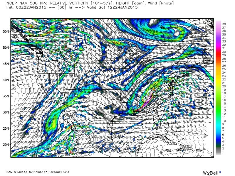 [/img]
_________________
"In weather and in life, there's no winning and losing; there's only winning and learning."
WINTER 2012/2013 TOTALS 43.65"WINTER 2017/2018 TOTALS 62.85" WINTER 2022/2023 TOTALS 4.9"
WINTER 2013/2014 TOTALS 64.85"WINTER 2018/2019 TOTALS 14.25" WINTER 2023/2024 TOTALS 13.1"
WINTER 2014/2015 TOTALS 71.20"WINTER 2019/2020 TOTALS 6.35"
WINTER 2015/2016 TOTALS 35.00"WINTER 2020/2021 TOTALS 37.75"
WINTER 2016/2017 TOTALS 42.25"WINTER 2021/2022 TOTALS 31.65"
sroc4- Admin
- Posts : 8331
Reputation : 301
Join date : 2013-01-07
Location : Wading River, LI
Re: Update #2: EURO Brings The Heat, Same Ol' GFS? (1/24/15)
![]() by carvin1079 Wed Jan 21, 2015 9:41 pm
by carvin1079 Wed Jan 21, 2015 9:41 pm
carvin1079- Posts : 61
Reputation : 0
Join date : 2014-11-06
Analog96- Meteorologist
- Posts : 156
Reputation : 1
Join date : 2014-03-12
Location : Elizabeth, NJ
Re: Update #2: EURO Brings The Heat, Same Ol' GFS? (1/24/15)
![]() by jmanley32 Wed Jan 21, 2015 9:43 pm
by jmanley32 Wed Jan 21, 2015 9:43 pm
jmanley32- Senior Enthusiast
- Posts : 20516
Reputation : 108
Join date : 2013-12-12
Age : 42
Location : Yonkers, NY
Re: Update #2: EURO Brings The Heat, Same Ol' GFS? (1/24/15)
![]() by sroc4 Wed Jan 21, 2015 9:43 pm
by sroc4 Wed Jan 21, 2015 9:43 pm
LP passing S E of MB on this run
_________________
"In weather and in life, there's no winning and losing; there's only winning and learning."
WINTER 2012/2013 TOTALS 43.65"WINTER 2017/2018 TOTALS 62.85" WINTER 2022/2023 TOTALS 4.9"
WINTER 2013/2014 TOTALS 64.85"WINTER 2018/2019 TOTALS 14.25" WINTER 2023/2024 TOTALS 13.1"
WINTER 2014/2015 TOTALS 71.20"WINTER 2019/2020 TOTALS 6.35"
WINTER 2015/2016 TOTALS 35.00"WINTER 2020/2021 TOTALS 37.75"
WINTER 2016/2017 TOTALS 42.25"WINTER 2021/2022 TOTALS 31.65"
sroc4- Admin
- Posts : 8331
Reputation : 301
Join date : 2013-01-07
Location : Wading River, LI
Page 2 of 11 • 1, 2, 3, ... 9, 10, 11 ![]()