
 Search
Update #2: EURO Brings The Heat, Same Ol' GFS? (1/24/15)
Page 11 of 11 •  1, 2, 3 ... 9, 10, 11
Re: Update #2: EURO Brings The Heat, Same Ol' GFS? (1/24/15)
![]() by Scullybutcher Thu Jan 22, 2015 3:28 pm
by Scullybutcher Thu Jan 22, 2015 3:28 pm
sroc4 wrote:I think there are surprises in store for this storm. Nothing crazy but remember you have to smell the rain to get the heavy snow. N Shore LI needs to watch closely. And no global model will show it. Watch the short range guidance starting late friday. Im not talking about wide spread surprises, but I would be willing to bet some of us on here will see surprise accum.
Look at that sliver of -1* 850MB temps over LI separate from the main 0*C line N and W of NYC. This is as the center of the LP is on the BM and at 985mb and continuing bombogenisis because 6hrs later its 975mb. That has shown up on several runs. That is where the heaviest precip rates are falling. If strong CCB bands set up right a change over may not occur or only occur for a short time in places and for people who are currently throwing in the towel." />
Its only THURSDAY. Look what happened with our clipper. Just saying.
That's why I love the north shore. We always seem to get more. Hope your analysis pans out
Scullybutcher- Pro Enthusiast

- Posts : 543
Join date : 2013-02-06
Re: Update #2: EURO Brings The Heat, Same Ol' GFS? (1/24/15)
![]() by algae888 Thu Jan 22, 2015 3:32 pm
by algae888 Thu Jan 22, 2015 3:32 pm
algae888- Advanced Forecaster

- Posts : 5311
Join date : 2013-02-05
Re: Update #2: EURO Brings The Heat, Same Ol' GFS? (1/24/15)
![]() by Quietace Thu Jan 22, 2015 3:35 pm
by Quietace Thu Jan 22, 2015 3:35 pm

Quietace- Meteorologist - Mod

- Posts : 3687
Reputation : 33
Join date : 2013-01-07
Age : 27
Location : Point Pleasant, NJ
Re: Update #2: EURO Brings The Heat, Same Ol' GFS? (1/24/15)
![]() by RJB8525 Thu Jan 22, 2015 3:36 pm
by RJB8525 Thu Jan 22, 2015 3:36 pm
Saturday: Snow likely before noon, then rain and snow. High near 35. Wind chill values between 25 and 30. Calm wind becoming north 5 to 9 mph in the morning. Chance of precipitation is 80%. New snow accumulation of 3 to 5 inches possible.

RJB8525- Senior Enthusiast

- Posts : 1994
Reputation : 28
Join date : 2013-02-06
Age : 38
Location : Hackettstown, NJ
Re: Update #2: EURO Brings The Heat, Same Ol' GFS? (1/24/15)
![]() by Guest Thu Jan 22, 2015 3:42 pm
by Guest Thu Jan 22, 2015 3:42 pm
Guest- Guest
Re: Update #2: EURO Brings The Heat, Same Ol' GFS? (1/24/15)
![]() by SoulSingMG Thu Jan 22, 2015 4:05 pm
by SoulSingMG Thu Jan 22, 2015 4:05 pm

SoulSingMG- Senior Enthusiast
- Posts : 2853
Reputation : 74
Join date : 2013-12-11
Location : Long Island City, NY
Re: Update #2: EURO Brings The Heat, Same Ol' GFS? (1/24/15)
![]() by RJB8525 Thu Jan 22, 2015 4:13 pm
by RJB8525 Thu Jan 22, 2015 4:13 pm
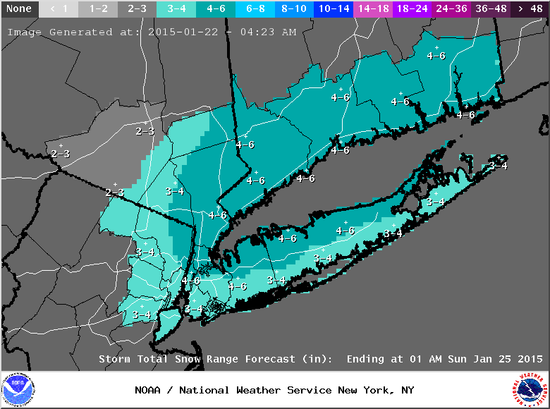
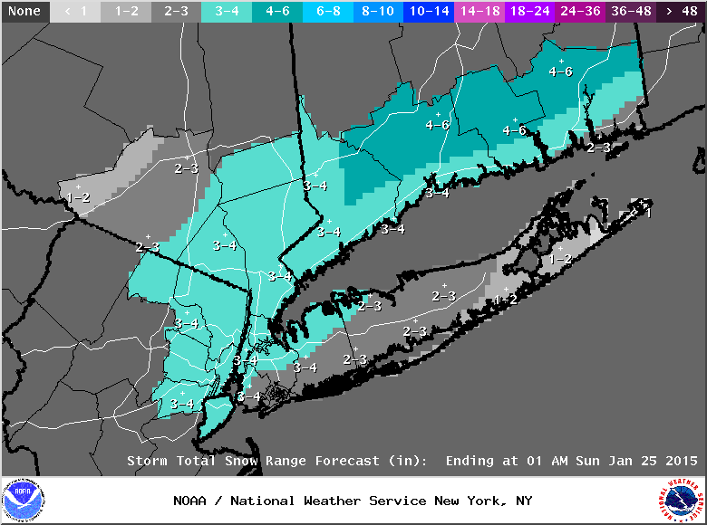
SoulSingMG wrote:UPTON just lowered snow fall totals for alllllll of us. On my phone so I can't post map.
RJB8525- Senior Enthusiast
- Posts : 1994
Reputation : 28
Join date : 2013-02-06
Age : 38
Location : Hackettstown, NJ
Re: Update #2: EURO Brings The Heat, Same Ol' GFS? (1/24/15)
![]() by docstox12 Thu Jan 22, 2015 4:29 pm
by docstox12 Thu Jan 22, 2015 4:29 pm
sroc4 wrote:I think there are surprises in store for this storm. Nothing crazy but remember you have to smell the rain to get the heavy snow. N Shore LI needs to watch closely. And no global model will show it. Watch the short range guidance starting late friday. Im not talking about wide spread surprises, but I would be willing to bet some of us on here will see surprise accum.
Look at that sliver of -1* 850MB temps over LI separate from the main 0*C line N and W of NYC. This is as the center of the LP is on the BM and at 985mb and continuing bombogenisis because 6hrs later its 975mb. That has shown up on several runs. That is where the heaviest precip rates are falling. If strong CCB bands set up right a change over may not occur or only occur for a short time in places and for people who are currently throwing in the towel.
Its only THURSDAY. Look what happened with our clipper. Just saying.
Doc, I like that thought you have about this storm possibly surprising.I have nothing but intuition of watching these snowstorms all these years, but this one is coming up from the Gulf to right near the benchmark.I know there is no cold high pressure up north, but this thing could really strengthen and cause more in the way of snow further west as well.Anyway, I think you Island guys have a good shot on this one.
Also right on the Thursday thought.Let's see the overnight models and what the morning brings.
Also, the Monday-Tuesday event is starting to look better according to NWS.
Happy days!!!!!!

docstox12- Wx Statistician Guru

- Posts : 8504
Reputation : 222
Join date : 2013-01-07
Age : 73
Location : Monroe NY
Re: Update #2: EURO Brings The Heat, Same Ol' GFS? (1/24/15)
![]() by RJB8525 Thu Jan 22, 2015 4:33 pm
by RJB8525 Thu Jan 22, 2015 4:33 pm
RJB8525- Senior Enthusiast
- Posts : 1994
Reputation : 28
Join date : 2013-02-06
Age : 38
Location : Hackettstown, NJ
Re: Update #2: EURO Brings The Heat, Same Ol' GFS? (1/24/15)
![]() by NjWeatherGuy Thu Jan 22, 2015 4:45 pm
by NjWeatherGuy Thu Jan 22, 2015 4:45 pm

NjWeatherGuy- Advanced Forecaster
- Posts : 4100
Reputation : 28
Join date : 2013-01-06
Location : Belle Mead, NJ
Re: Update #2: EURO Brings The Heat, Same Ol' GFS? (1/24/15)
![]() by SoulSingMG Thu Jan 22, 2015 4:47 pm
by SoulSingMG Thu Jan 22, 2015 4:47 pm
SoulSingMG- Senior Enthusiast
- Posts : 2853
Reputation : 74
Join date : 2013-12-11
Location : Long Island City, NY
Re: Update #2: EURO Brings The Heat, Same Ol' GFS? (1/24/15)
![]() by NjWeatherGuy Thu Jan 22, 2015 4:51 pm
by NjWeatherGuy Thu Jan 22, 2015 4:51 pm
NjWeatherGuy- Advanced Forecaster
- Posts : 4100
Reputation : 28
Join date : 2013-01-06
Location : Belle Mead, NJ
Re: Update #2: EURO Brings The Heat, Same Ol' GFS? (1/24/15)
![]() by SoulSingMG Thu Jan 22, 2015 4:52 pm
by SoulSingMG Thu Jan 22, 2015 4:52 pm
NjWeatherGuy wrote:In CNJ 18z RGEM has 4" of snow and a centimeter of freezing rain, yikes.
I wonder how the ice will pan out with this system. Seems to be a big concern for Upton but my understanding is that Nor'easters aren't really the big producers of ice storms. It's either snow, sleet, or rain.
SoulSingMG- Senior Enthusiast
- Posts : 2853
Reputation : 74
Join date : 2013-12-11
Location : Long Island City, NY
Re: Update #2: EURO Brings The Heat, Same Ol' GFS? (1/24/15)
![]() by NjWeatherGuy Thu Jan 22, 2015 4:54 pm
by NjWeatherGuy Thu Jan 22, 2015 4:54 pm
NjWeatherGuy- Advanced Forecaster
- Posts : 4100
Reputation : 28
Join date : 2013-01-06
Location : Belle Mead, NJ
Re: Update #2: EURO Brings The Heat, Same Ol' GFS? (1/24/15)
![]() by algae888 Thu Jan 22, 2015 4:55 pm
by algae888 Thu Jan 22, 2015 4:55 pm

algae888- Advanced Forecaster
- Posts : 5311
Reputation : 46
Join date : 2013-02-05
Age : 61
Location : mt. vernon, new york
Re: Update #2: EURO Brings The Heat, Same Ol' GFS? (1/24/15)
![]() by NjWeatherGuy Thu Jan 22, 2015 4:57 pm
by NjWeatherGuy Thu Jan 22, 2015 4:57 pm
GFS looks warm, strung out and horrible.algae888 wrote:on my cell phone so can't post maps but the 18z rgem looks really good. widespread 4 to 6 inches on the front end for the city in north New Jersey and then there's a lull or dry slot and then the next batch coming in after but its out of its range almost looks like it has too low pressure centers instead of one
NjWeatherGuy- Advanced Forecaster
- Posts : 4100
Reputation : 28
Join date : 2013-01-06
Location : Belle Mead, NJ
Re: Update #2: EURO Brings The Heat, Same Ol' GFS? (1/24/15)
![]() by algae888 Thu Jan 22, 2015 5:03 pm
by algae888 Thu Jan 22, 2015 5:03 pm
the 4k nam shows widespread 3 to 6 inch snow from southern New Jersey right through the city Long Island in Connecticut mostly with back end snows ccb. while it doesn't look like we'll get that big Godzilla types storm this one can still give us a nice moderate snow of about 6 inches for some parts of the area. I really like the rgem it has been pretty good this winter so far we shall seeNjWeatherGuy wrote:Bigtime mixing issues on the NAM after inital inch or two for just about everyone that sees any precip, common theme with todays runs, my expectations are pretty low atm i dont really like the look of this, thinking ceiling is maybe 4-5 inches for lucky people, 2-4 majority
edit: southern and central New Jersey get it mostly in the front end snow northern New Jersey Long Island Connecticut on the backend snows on the 4 km Nam
algae888- Advanced Forecaster
- Posts : 5311
Reputation : 46
Join date : 2013-02-05
Age : 61
Location : mt. vernon, new york
Re: Update #2: EURO Brings The Heat, Same Ol' GFS? (1/24/15)
![]() by algae888 Thu Jan 22, 2015 5:14 pm
by algae888 Thu Jan 22, 2015 5:14 pm
algae888- Advanced Forecaster
- Posts : 5311
Reputation : 46
Join date : 2013-02-05
Age : 61
Location : mt. vernon, new york
Re: Update #2: EURO Brings The Heat, Same Ol' GFS? (1/24/15)
![]() by rb924119 Thu Jan 22, 2015 5:32 pm
by rb924119 Thu Jan 22, 2015 5:32 pm
rb924119- Meteorologist

- Posts : 6890
Reputation : 194
Join date : 2013-02-06
Age : 32
Location : Greentown, Pa
Re: Update #2: EURO Brings The Heat, Same Ol' GFS? (1/24/15)
![]() by amugs Thu Jan 22, 2015 5:51 pm
by amugs Thu Jan 22, 2015 5:51 pm
_________________
Mugs
AKA:King: Snow Weenie
Self Proclaimed
WINTER 2014-15 : 55.12" +.02 for 6 coatings (avg. 35")
WINTER 2015-16 Total - 29.8" (Avg 35")
WINTER 2016-17 : 39.5" so far

amugs- Advanced Forecaster - Mod

- Posts : 15093
Reputation : 213
Join date : 2013-01-07
Age : 54
Location : Hillsdale,NJ
Re: Update #2: EURO Brings The Heat, Same Ol' GFS? (1/24/15)
![]() by jmanley32 Thu Jan 22, 2015 7:10 pm
by jmanley32 Thu Jan 22, 2015 7:10 pm

jmanley32- Senior Enthusiast
- Posts : 20516
Reputation : 108
Join date : 2013-12-12
Age : 42
Location : Yonkers, NY
Re: Update #2: EURO Brings The Heat, Same Ol' GFS? (1/24/15)
![]() by Frank_Wx Thu Jan 22, 2015 7:22 pm
by Frank_Wx Thu Jan 22, 2015 7:22 pm
_________________
_______________________________________________________________________________________________________
CLICK HERE to view NJ Strong Snowstorm Classifications

Frank_Wx- Godzilla Seeker

- Posts : 21305
Reputation : 328
Join date : 2013-01-05
Age : 31
Location : Jersey City, NJ -

Page 11 of 11 • 1, 2, 3 ... 9, 10, 11