
 Search
Update #3: Godzilla Caged, 1st Call Snow Map (1/24/15)
Page 10 of 11 •  1, 2, 3 ... , 9, 10, 11
 ![]()
Re: Update #3: Godzilla Caged, 1st Call Snow Map (1/24/15)
![]() by jmanley32 Fri Jan 23, 2015 3:16 pm
by jmanley32 Fri Jan 23, 2015 3:16 pm
jmanley32- Senior Enthusiast

- Posts : 20516
Join date : 2013-12-12
Re: Update #3: Godzilla Caged, 1st Call Snow Map (1/24/15)
![]() by rb924119 Fri Jan 23, 2015 3:22 pm
by rb924119 Fri Jan 23, 2015 3:22 pm
rb924119- Meteorologist

- Posts : 6890
Join date : 2013-02-06
Re: Update #3: Godzilla Caged, 1st Call Snow Map (1/24/15)
![]() by Guest Fri Jan 23, 2015 3:27 pm
by Guest Fri Jan 23, 2015 3:27 pm
Guest- Guest
Re: Update #3: Godzilla Caged, 1st Call Snow Map (1/24/15)
![]() by jmanley32 Fri Jan 23, 2015 3:30 pm
by jmanley32 Fri Jan 23, 2015 3:30 pm

jmanley32- Senior Enthusiast
- Posts : 20516
Reputation : 108
Join date : 2013-12-12
Age : 42
Location : Yonkers, NY
Re: Update #3: Godzilla Caged, 1st Call Snow Map (1/24/15)
![]() by jmanley32 Fri Jan 23, 2015 3:32 pm
by jmanley32 Fri Jan 23, 2015 3:32 pm
jmanley32- Senior Enthusiast
- Posts : 20516
Reputation : 108
Join date : 2013-12-12
Age : 42
Location : Yonkers, NY
Re: Update #3: Godzilla Caged, 1st Call Snow Map (1/24/15)
![]() by jmanley32 Fri Jan 23, 2015 3:33 pm
by jmanley32 Fri Jan 23, 2015 3:33 pm
jmanley32- Senior Enthusiast
- Posts : 20516
Reputation : 108
Join date : 2013-12-12
Age : 42
Location : Yonkers, NY
Re: Update #3: Godzilla Caged, 1st Call Snow Map (1/24/15)
![]() by algae888 Fri Jan 23, 2015 3:33 pm
by algae888 Fri Jan 23, 2015 3:33 pm

algae888- Advanced Forecaster

- Posts : 5311
Reputation : 46
Join date : 2013-02-05
Age : 61
Location : mt. vernon, new york
Re: Update #3: Godzilla Caged, 1st Call Snow Map (1/24/15)
![]() by amugs Fri Jan 23, 2015 3:35 pm
by amugs Fri Jan 23, 2015 3:35 pm
.TONIGHT...SNOW...MAINLY AFTER MIDNIGHT. SNOW MAY BE HEAVY AT TIMES
AFTER MIDNIGHT. SNOW ACCUMULATION OF 2 TO 4 INCHES. LOWS IN THE
LOWER 30S. SOUTHWEST WINDS AROUND 5 MPH...INCREASING TO SOUTHEAST
10 TO 15 MPH WITH GUSTS UP TO 25 MPH AFTER MIDNIGHT. CHANCE OF SNOW
NEAR 100 PERCENT.
.SATURDAY...SLEET...RAIN AND FREEZING RAIN IN THE MORNING...THEN
RAIN AND SLEET LIKELY IN THE AFTERNOON. TOTAL SLEET ACCUMULATION OF
3 TO 5 INCHES. ICE ACCUMULATION AROUND A TRACE. BREEZY. NEAR STEADY
TEMPERATURE IN THE LOWER 30S. NORTH WINDS 15 TO 20 MPH...BECOMING
NORTHWEST IN THE AFTERNOON. GUSTS UP TO 30 MPH. CHANCE OF
PRECIPITATION NEAR 100 PERCENT.
_________________
Mugs
AKA:King: Snow Weenie
Self Proclaimed
WINTER 2014-15 : 55.12" +.02 for 6 coatings (avg. 35")
WINTER 2015-16 Total - 29.8" (Avg 35")
WINTER 2016-17 : 39.5" so far

amugs- Advanced Forecaster - Mod

- Posts : 15093
Reputation : 213
Join date : 2013-01-07
Age : 54
Location : Hillsdale,NJ
Re: Update #3: Godzilla Caged, 1st Call Snow Map (1/24/15)
![]() by jmanley32 Fri Jan 23, 2015 3:39 pm
by jmanley32 Fri Jan 23, 2015 3:39 pm

jmanley32- Senior Enthusiast
- Posts : 20516
Reputation : 108
Join date : 2013-12-12
Age : 42
Location : Yonkers, NY
jmanley32- Senior Enthusiast
- Posts : 20516
Reputation : 108
Join date : 2013-12-12
Age : 42
Location : Yonkers, NY
Re: Update #3: Godzilla Caged, 1st Call Snow Map (1/24/15)
![]() by jmanley32 Fri Jan 23, 2015 3:41 pm
by jmanley32 Fri Jan 23, 2015 3:41 pm

jmanley32- Senior Enthusiast
- Posts : 20516
Reputation : 108
Join date : 2013-12-12
Age : 42
Location : Yonkers, NY
Re: Update #3: Godzilla Caged, 1st Call Snow Map (1/24/15)
![]() by essexcountypete Fri Jan 23, 2015 3:42 pm
by essexcountypete Fri Jan 23, 2015 3:42 pm
amugs wrote:"...TOTAL SLEET ACCUMULATION OF 3 TO 5 INCHES."
Mama mia! That's a lot of sleet. I guess that much is possible, but I find it hard to believe the NWS thinks anyone is going to get 3-5" of sleet. That's got to be a total of snow and sleet together.

essexcountypete- Pro Enthusiast

- Posts : 783
Reputation : 12
Join date : 2013-12-09
Location : Bloomfield, NJ
Re: Update #3: Godzilla Caged, 1st Call Snow Map (1/24/15)
![]() by oldtimer Fri Jan 23, 2015 3:42 pm
by oldtimer Fri Jan 23, 2015 3:42 pm
oldtimer- Senior Enthusiast
- Posts : 1103
Reputation : 14
Join date : 2013-01-16
Age : 78
Location : Port Jefferson Station Suffolk County
Re: Update #3: Godzilla Caged, 1st Call Snow Map (1/24/15)
![]() by jmanley32 Fri Jan 23, 2015 3:43 pm
by jmanley32 Fri Jan 23, 2015 3:43 pm
jmanley32- Senior Enthusiast
- Posts : 20516
Reputation : 108
Join date : 2013-12-12
Age : 42
Location : Yonkers, NY
Re: Update #3: Godzilla Caged, 1st Call Snow Map (1/24/15)
![]() by rb924119 Fri Jan 23, 2015 3:44 pm
by rb924119 Fri Jan 23, 2015 3:44 pm
jmanley32 wrote:rb where do u look at srefs and do they have snow totals?
http://mp1.met.psu.edu/~fxg1/ewallsref.html
rb924119- Meteorologist
- Posts : 6890
Reputation : 194
Join date : 2013-02-06
Age : 32
Location : Greentown, Pa
Re: Update #3: Godzilla Caged, 1st Call Snow Map (1/24/15)
![]() by jmanley32 Fri Jan 23, 2015 3:45 pm
by jmanley32 Fri Jan 23, 2015 3:45 pm
jmanley32- Senior Enthusiast
- Posts : 20516
Reputation : 108
Join date : 2013-12-12
Age : 42
Location : Yonkers, NY
Re: Update #3: Godzilla Caged, 1st Call Snow Map (1/24/15)
![]() by jmanley32 Fri Jan 23, 2015 3:47 pm
by jmanley32 Fri Jan 23, 2015 3:47 pm
jmanley32- Senior Enthusiast
- Posts : 20516
Reputation : 108
Join date : 2013-12-12
Age : 42
Location : Yonkers, NY
Re: Update #3: Godzilla Caged, 1st Call Snow Map (1/24/15)
![]() by Dunnzoo Fri Jan 23, 2015 3:47 pm
by Dunnzoo Fri Jan 23, 2015 3:47 pm
syosnow94 wrote:Just got home. ALL LOCAL PRO METS ON RADIO (I listened to 5 different forecasts) HAVE AT MOST 1 to 3" city on east and south and 3 to 5' north and west before a changeover. And that's total storm accumulations. What gives? I also posted that I thought NWS would have updated the entire area except Eastern LI to a WS Warning but they haven't budged yet. Someone in this scenario either us on here or the local METS are gonna look real bad tomorrow!!!!
easy there! The mets on the networks are always conservative since they blew that blizzard forecast years ago. They will wait until 6 or 11:00 to change any amounts...don't want to look bad again.
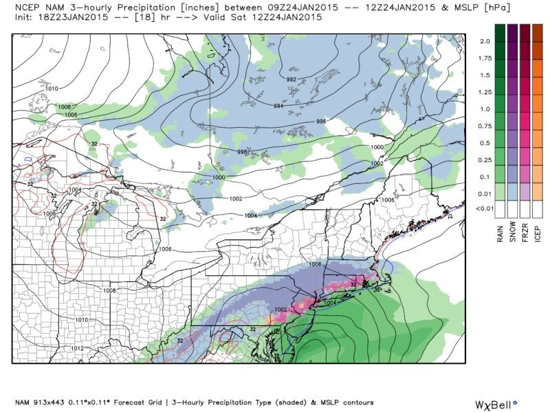
Also, many of you are looking at the NAM, it overdoes the precip so don't get too excited...
_________________
Janet
Snowfall winter of 2023-2024 17.5"
Snowfall winter of 2022-2023 6.0"
Snowfall winter of 2021-2022 17.6" 1" sleet 2/25/22
Snowfall winter of 2020-2021 51.1"
Snowfall winter of 2019-2020 8.5"
Snowfall winter of 2018-2019 25.1"
Snowfall winter of 2017-2018 51.9"
Snowfall winter of 2016-2017 45.6"
Snowfall winter of 2015-2016 29.5"
Snowfall winter of 2014-2015 50.55"
Snowfall winter of 2013-2014 66.5"

Dunnzoo- Senior Enthusiast - Mod
- Posts : 4891
Reputation : 68
Join date : 2013-01-11
Age : 62
Location : Westwood, NJ
Re: Update #3: Godzilla Caged, 1st Call Snow Map (1/24/15)
![]() by jmanley32 Fri Jan 23, 2015 3:48 pm
by jmanley32 Fri Jan 23, 2015 3:48 pm
NORTHERN MIDDLESEX-NORTHERN NEW LONDON-SOUTHERN FAIRFIELD-
SOUTHERN NEW HAVEN-SOUTHERN MIDDLESEX-WESTERN PASSAIC-
EASTERN PASSAIC-WESTERN BERGEN-EASTERN BERGEN-ORANGE-ROCKLAND-
NORTHERN WESTCHESTER-SOUTHERN WESTCHESTER-
336 PM EST FRI JAN 23 2015
...WINTER WEATHER ADVISORY REMAINS IN EFFECT FROM MIDNIGHT
TONIGHT TO 6 PM EST SATURDAY...
* LOCATIONS...MUCH OF SOUTHERN CONNECTICUT...THE LOWER HUDSON
VALLEY...AND INTERIOR NORTHEASTERN NEW JERSEY
* HAZARD TYPES...SNOW AND ICE.
* ACCUMULATIONS...SNOW ACCUMULATION OF 3 TO 5 INCHES...WITH
LOCALLY 6 INCH AMOUNTS. 1 TO 2 TENTHS OF AN INCH OF ICE.
* VISIBILITY...ONE QUARTER MILE OR LESS AT TIMES SATURDAY
MORNING.
* SNOWFALL RATES...1 INCH PER HOUR EARLY TO MID SATURDAY MORNING.
* TIMING...SNOW BEGINS LATE TONIGHT. SNOW WILL BECOME MODERATE TO
HEAVY EARLY SATURDAY MORNING...THEN MIX WITH AND CHANGE TO SLEET
AND FREEZING RAIN AND RAIN DURING THE MID TO LATE MORNING.
PRECIP SHOULD THEN GRADUALLY CHANGING BACK TO SNOW MID TO LATE
SATURDAY AFTERNOON BEFORE ENDING IN THE EVENING.
jmanley32- Senior Enthusiast
- Posts : 20516
Reputation : 108
Join date : 2013-12-12
Age : 42
Location : Yonkers, NY
Re: Update #3: Godzilla Caged, 1st Call Snow Map (1/24/15)
![]() by rb924119 Fri Jan 23, 2015 3:49 pm
by rb924119 Fri Jan 23, 2015 3:49 pm
jmanley32 wrote:that sref is out of its mind believes mostly rain, nah.
I'm being totally honest when I say this, and am certainly NOT trying to be a downer, but from my own personal experience they are LETHAL in this timeframe.
rb924119- Meteorologist
- Posts : 6890
Reputation : 194
Join date : 2013-02-06
Age : 32
Location : Greentown, Pa
Re: Update #3: Godzilla Caged, 1st Call Snow Map (1/24/15)
![]() by amugs Fri Jan 23, 2015 3:51 pm
by amugs Fri Jan 23, 2015 3:51 pm

Blow ur min on this snow map
_________________
Mugs
AKA:King: Snow Weenie
Self Proclaimed
WINTER 2014-15 : 55.12" +.02 for 6 coatings (avg. 35")
WINTER 2015-16 Total - 29.8" (Avg 35")
WINTER 2016-17 : 39.5" so far
amugs- Advanced Forecaster - Mod
- Posts : 15093
Reputation : 213
Join date : 2013-01-07
Age : 54
Location : Hillsdale,NJ
Re: Update #3: Godzilla Caged, 1st Call Snow Map (1/24/15)
![]() by jmanley32 Fri Jan 23, 2015 3:52 pm
by jmanley32 Fri Jan 23, 2015 3:52 pm
jmanley32- Senior Enthusiast
- Posts : 20516
Reputation : 108
Join date : 2013-12-12
Age : 42
Location : Yonkers, NY
Re: Update #3: Godzilla Caged, 1st Call Snow Map (1/24/15)
![]() by Guest Fri Jan 23, 2015 3:54 pm
by Guest Fri Jan 23, 2015 3:54 pm
Guest- Guest
Re: Update #3: Godzilla Caged, 1st Call Snow Map (1/24/15)
![]() by Guest Fri Jan 23, 2015 3:58 pm
by Guest Fri Jan 23, 2015 3:58 pm
oldtimer wrote:Mugs I dont think its a good idea for Syo to rant
What??
Guest- Guest
Re: Update #3: Godzilla Caged, 1st Call Snow Map (1/24/15)
![]() by Analog96 Fri Jan 23, 2015 4:11 pm
by Analog96 Fri Jan 23, 2015 4:11 pm
rb924119 wrote:jmanley32 wrote:that sref is out of its mind believes mostly rain, nah.
I'm being totally honest when I say this, and am certainly NOT trying to be a downer, but from my own personal experience they are LETHAL in this timeframe.
I haven't used SREFS for any part of any operational forecast one time in my life.
Analog96- Meteorologist
- Posts : 156
Reputation : 1
Join date : 2014-03-12
Location : Elizabeth, NJ
Re: Update #3: Godzilla Caged, 1st Call Snow Map (1/24/15)
![]() by jmanley32 Fri Jan 23, 2015 4:16 pm
by jmanley32 Fri Jan 23, 2015 4:16 pm
jmanley32- Senior Enthusiast
- Posts : 20516
Reputation : 108
Join date : 2013-12-12
Age : 42
Location : Yonkers, NY
Re: Update #3: Godzilla Caged, 1st Call Snow Map (1/24/15)
![]() by Analog96 Fri Jan 23, 2015 4:17 pm
by Analog96 Fri Jan 23, 2015 4:17 pm
jmanley32 wrote:Well syo all I can say is if it ices it ices if it doesn't it doesn't, no one will know till tomorrow, just becareful if it does and stay in if you can. And the winds are forecast to shift per NWS. Like Janet said mets are being cautious, this is common.
How would winds not have a northerly component with a strong low to your east?
Analog96- Meteorologist
- Posts : 156
Reputation : 1
Join date : 2014-03-12
Location : Elizabeth, NJ
Page 10 of 11 • 1, 2, 3 ... , 9, 10, 11 ![]()