
 Search
Update #1: Can NJ Make Up For Blizzard Bust?
Page 16 of 17 •  1 ... 9 ... 15, 16, 17
 ![]()
Re: Update #1: Can NJ Make Up For Blizzard Bust?
![]() by aiannone Fri Jan 30, 2015 11:53 pm
by aiannone Fri Jan 30, 2015 11:53 pm
rb924119 wrote:From what I can tell so far, which is purely based on thicknesses at the moment, the UKMET looks to go to rain or a mix all the way to or damn near Albany, NY. I'm awaiting more data, though.
UKMET is north, so warm for coastal areas....

aiannone- Senior Enthusiast - Mod

- Posts : 4813
Join date : 2013-01-07
Re: Update #1: Can NJ Make Up For Blizzard Bust?
![]() by rb924119 Fri Jan 30, 2015 11:55 pm
by rb924119 Fri Jan 30, 2015 11:55 pm
http://img.meteocentre.com/models/ukmet_amer_00/accum/PA_000-072_0000.gif
rb924119- Meteorologist

- Posts : 6890
Join date : 2013-02-06
Re: Update #1: Can NJ Make Up For Blizzard Bust?
![]() by rb924119 Fri Jan 30, 2015 11:58 pm
by rb924119 Fri Jan 30, 2015 11:58 pm
rb924119- Meteorologist
- Posts : 6890
Reputation : 194
Join date : 2013-02-06
Age : 32
Location : Greentown, Pa
Re: Update #1: Can NJ Make Up For Blizzard Bust?
![]() by Frank_Wx Fri Jan 30, 2015 11:58 pm
by Frank_Wx Fri Jan 30, 2015 11:58 pm
_________________
_______________________________________________________________________________________________________
CLICK HERE to view NJ Strong Snowstorm Classifications

Frank_Wx- Godzilla Seeker

- Posts : 21305
Reputation : 328
Join date : 2013-01-05
Age : 31
Location : Jersey City, NJ -

Re: Update #1: Can NJ Make Up For Blizzard Bust?
![]() by Frank_Wx Fri Jan 30, 2015 11:58 pm
by Frank_Wx Fri Jan 30, 2015 11:58 pm
_________________
_______________________________________________________________________________________________________
CLICK HERE to view NJ Strong Snowstorm Classifications
Frank_Wx- Godzilla Seeker
- Posts : 21305
Reputation : 328
Join date : 2013-01-05
Age : 31
Location : Jersey City, NJ -
Re: Update #1: Can NJ Make Up For Blizzard Bust?
![]() by rb924119 Fri Jan 30, 2015 11:59 pm
by rb924119 Fri Jan 30, 2015 11:59 pm
http://images0.earthsat.com/misc/mod-images/GFS/EN/00/snosums/0024/GFS_00_enUS_SF_0066.png
rb924119- Meteorologist
- Posts : 6890
Reputation : 194
Join date : 2013-02-06
Age : 32
Location : Greentown, Pa
Re: Update #1: Can NJ Make Up For Blizzard Bust?
![]() by rb924119 Fri Jan 30, 2015 11:59 pm
by rb924119 Fri Jan 30, 2015 11:59 pm
rb924119- Meteorologist
- Posts : 6890
Reputation : 194
Join date : 2013-02-06
Age : 32
Location : Greentown, Pa
Re: Update #1: Can NJ Make Up For Blizzard Bust?
![]() by rb924119 Sat Jan 31, 2015 12:00 am
by rb924119 Sat Jan 31, 2015 12:00 am
rb924119- Meteorologist
- Posts : 6890
Reputation : 194
Join date : 2013-02-06
Age : 32
Location : Greentown, Pa
Re: Update #1: Can NJ Make Up For Blizzard Bust?
![]() by Frank_Wx Sat Jan 31, 2015 12:01 am
by Frank_Wx Sat Jan 31, 2015 12:01 am
_________________
_______________________________________________________________________________________________________
CLICK HERE to view NJ Strong Snowstorm Classifications
Frank_Wx- Godzilla Seeker
- Posts : 21305
Reputation : 328
Join date : 2013-01-05
Age : 31
Location : Jersey City, NJ -
Re: Update #1: Can NJ Make Up For Blizzard Bust?
![]() by rb924119 Sat Jan 31, 2015 12:04 am
by rb924119 Sat Jan 31, 2015 12:04 am
rb924119- Meteorologist
- Posts : 6890
Reputation : 194
Join date : 2013-02-06
Age : 32
Location : Greentown, Pa
Re: Update #1: Can NJ Make Up For Blizzard Bust?
![]() by rb924119 Sat Jan 31, 2015 12:04 am
by rb924119 Sat Jan 31, 2015 12:04 am
Frank_Wx wrote:Snow map will be out by morning. I'm going to enjoy my night for now. Goodnight
Looking very forward to it, my friend! Ciao!!
rb924119- Meteorologist
- Posts : 6890
Reputation : 194
Join date : 2013-02-06
Age : 32
Location : Greentown, Pa
Re: Update #1: Can NJ Make Up For Blizzard Bust?
![]() by rb924119 Sat Jan 31, 2015 12:08 am
by rb924119 Sat Jan 31, 2015 12:08 am
rb924119- Meteorologist
- Posts : 6890
Reputation : 194
Join date : 2013-02-06
Age : 32
Location : Greentown, Pa
Re: Update #1: Can NJ Make Up For Blizzard Bust?
![]() by rb924119 Sat Jan 31, 2015 12:14 am
by rb924119 Sat Jan 31, 2015 12:14 am
rb924119- Meteorologist
- Posts : 6890
Reputation : 194
Join date : 2013-02-06
Age : 32
Location : Greentown, Pa
Re: Update #1: Can NJ Make Up For Blizzard Bust?
![]() by NjWeatherGuy Sat Jan 31, 2015 12:18 am
by NjWeatherGuy Sat Jan 31, 2015 12:18 am
Livin On The Edge - Aerosmithrb924119 wrote:aiannone wrote:CMC total snowfall with ratios. So now NAM, GFS, and CMC are on board for 6-8" here. Just when i thought we would be sunny here lol
GOOD LORD ALMIGHTY!!! Where's the dotted line?!! I'll sign in blood if needed lmfao

Great song, gonna be listening to alot next 48 hrs

NjWeatherGuy- Advanced Forecaster

- Posts : 4100
Reputation : 28
Join date : 2013-01-06
Location : Belle Mead, NJ
Re: Update #1: Can NJ Make Up For Blizzard Bust?
![]() by Math23x7 Sat Jan 31, 2015 12:25 am
by Math23x7 Sat Jan 31, 2015 12:25 am
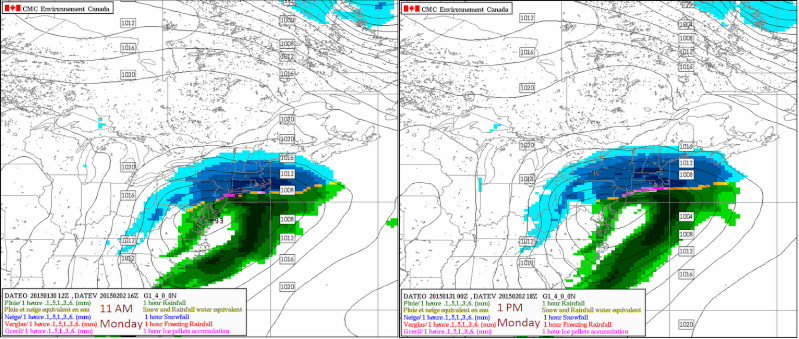
I posted this on facebook in regards to the potential Sunday night-Monday storm:
Unlike the last storm, which was all snow with the question of how far west or east will the low pressure system go, this storm looks to have a snow/ice/rain issue with the question of how far north or south the low will go, which determines how far north the snow/mix line will go.
Here are two images from the last two Canadian model runs. The image on the left is hour 76 of the 1/30 12Z run valid for 11 AM Monday. In this run, the mixing line stops right over NYC and LI. The image on the right is hr 66 of the 1/31 0Z run valid for 1 PM Monday. In this run, the mixing line goes as far north as the Tappan Zee Bridge.
The areas north of where this mixing line stops will get all snow out of this (and those just north of it will likely get over a foot of snow from it). Those just south of the line will see a changeover but with really cold temperatures at the surface, it will likely be in the form of sleet and freezing rain. Further south of the line, you get a changeover to plain rain as surface temperatures look to warm above 32 degrees in those locations. But I do think that everyone in the NYC region will begin as snow Sunday evening and end as snow Monday evening.
Yes it is the Canadian model and yes I know not to put all the eggs into one model. Other models have the mixing line well north of where the Canadian has it while other models have it further south. This was just to give you an idea of what I think the wild card is in forecasting this storm. As we get closer, the short range models (with higher resolution) will provide us with more detailed analysis over how far north the line will go.
Math23x7- Wx Statistician Guru

- Posts : 2379
Reputation : 68
Join date : 2013-01-08
Re: Update #1: Can NJ Make Up For Blizzard Bust?
![]() by LB3147 Sat Jan 31, 2015 12:38 am
by LB3147 Sat Jan 31, 2015 12:38 am
NjWeatherGuy wrote:Im not taking it verbatim at all, just using it for its trends. It has had its moments in the past. Like I said, more concerned by having moving N past 3 runs and looking similar to Ukie.Frank_Wx wrote:NjWeatherGuy wrote:NAM goes thru CNJ everyone goes to rain after a couple inches of snow, would stay the course of a winter of disappointment after disappointment.
ARE YOU KIDDING ME?? DON'T LOOK AT THIS PUTID MODEL. LAST NIGHT IT DID NOT EVEN SHOW THE SNOW SQUALLS TODAY FOR THE AREA. 0 INCHES OF SNOW WHILE WE ALL GOT 1-3. THEN 8 HOURS BEFORE THE BLIZZARD SHOW 24-30 INCHES OF SNOW FOR NYC. THIS MODEL NEEDS TO BE DECOMMISSIONED OR ELSE MORE PEOPLE WILL CONTINUING TO GROW DUMBER BY THE DAY
I guess all the forum rules and threats Frank made us read dont apply to himself, degrading response IMO
LB3147- Posts : 31
Reputation : 0
Join date : 2014-11-11
Re: Update #1: Can NJ Make Up For Blizzard Bust?
![]() by Frank_Wx Sat Jan 31, 2015 1:12 am
by Frank_Wx Sat Jan 31, 2015 1:12 am
00z euro is all snow, about 10-15 inches
_________________
_______________________________________________________________________________________________________
CLICK HERE to view NJ Strong Snowstorm Classifications
Frank_Wx- Godzilla Seeker
- Posts : 21305
Reputation : 328
Join date : 2013-01-05
Age : 31
Location : Jersey City, NJ -
Re: Update #1: Can NJ Make Up For Blizzard Bust?
![]() by Math23x7 Sat Jan 31, 2015 1:13 am
by Math23x7 Sat Jan 31, 2015 1:13 am
Math23x7- Wx Statistician Guru
- Posts : 2379
Reputation : 68
Join date : 2013-01-08
Re: Update #1: Can NJ Make Up For Blizzard Bust?
![]() by Frank_Wx Sat Jan 31, 2015 1:15 am
by Frank_Wx Sat Jan 31, 2015 1:15 am

_________________
_______________________________________________________________________________________________________
CLICK HERE to view NJ Strong Snowstorm Classifications
Frank_Wx- Godzilla Seeker
- Posts : 21305
Reputation : 328
Join date : 2013-01-05
Age : 31
Location : Jersey City, NJ -
Re: Update #1: Can NJ Make Up For Blizzard Bust?
![]() by Frank_Wx Sat Jan 31, 2015 1:16 am
by Frank_Wx Sat Jan 31, 2015 1:16 am
_________________
_______________________________________________________________________________________________________
CLICK HERE to view NJ Strong Snowstorm Classifications
Frank_Wx- Godzilla Seeker
- Posts : 21305
Reputation : 328
Join date : 2013-01-05
Age : 31
Location : Jersey City, NJ -
Re: Update #1: Can NJ Make Up For Blizzard Bust?
![]() by Joe Snow Sat Jan 31, 2015 1:18 am
by Joe Snow Sat Jan 31, 2015 1:18 am
LB3147 wrote:NjWeatherGuy wrote:Im not taking it verbatim at all, just using it for its trends. It has had its moments in the past. Like I said, more concerned by having moving N past 3 runs and looking similar to Ukie.Frank_Wx wrote:NjWeatherGuy wrote:NAM goes thru CNJ everyone goes to rain after a couple inches of snow, would stay the course of a winter of disappointment after disappointment.
ARE YOU KIDDING ME?? DON'T LOOK AT THIS PUTID MODEL. LAST NIGHT IT DID NOT EVEN SHOW THE SNOW SQUALLS TODAY FOR THE AREA. 0 INCHES OF SNOW WHILE WE ALL GOT 1-3. THEN 8 HOURS BEFORE THE BLIZZARD SHOW 24-30 INCHES OF SNOW FOR NYC. THIS MODEL NEEDS TO BE DECOMMISSIONED OR ELSE MORE PEOPLE WILL CONTINUING TO GROW DUMBER BY THE DAY
I guess all the forum rules and threats Frank made us read dont apply to himself, degrading response IMO
He's just pointing out how poor the model is, really can't rely on it, it needs to be fixed. ie it sucks. Everyone AGAIN is model hugging, did we not learn from the last storm? We need to look at all the data available as well as the current conditions and the model guidance to be able to forecast correctly.............jUst because one model shows a trend to the North does not mean it will actually trend that way..........LOOK AT ALL THE DATA, before forming an opinion.

Joe Snow- Pro Enthusiast

- Posts : 924
Reputation : 7
Join date : 2014-02-12
Age : 62
Location : Sanford Florida, Fmrly Kings Park, NY
Re: Update #1: Can NJ Make Up For Blizzard Bust?
![]() by NjWeatherGuy Sat Jan 31, 2015 1:19 am
by NjWeatherGuy Sat Jan 31, 2015 1:19 am
Frank_Wx wrote:The low transferred to the coast sooner than the GGEM/GFS
It is about 15 miles further north, and Im still worried and not letting the EURO keep my hopes up in an all snow event when other models disagree.
NjWeatherGuy- Advanced Forecaster
- Posts : 4100
Reputation : 28
Join date : 2013-01-06
Location : Belle Mead, NJ
Re: Update #1: Can NJ Make Up For Blizzard Bust?
![]() by Math23x7 Sat Jan 31, 2015 1:21 am
by Math23x7 Sat Jan 31, 2015 1:21 am
http://models.weatherbell.com/ecmwf/2015013100/nyc/ecmwf_t850_nyc_12.png
Math23x7- Wx Statistician Guru
- Posts : 2379
Reputation : 68
Join date : 2013-01-08
Re: Update #1: Can NJ Make Up For Blizzard Bust?
![]() by Frank_Wx Sat Jan 31, 2015 1:22 am
by Frank_Wx Sat Jan 31, 2015 1:22 am
Math23x7 wrote:Frank I was looking at this (hr 66)
http://models.weatherbell.com/ecmwf/2015013100/nyc/ecmwf_t850_nyc_12.png
That's still cold enough. Maybe not high-ratio cold, but when you have cold 925mb and surface you will have snow.
_________________
_______________________________________________________________________________________________________
CLICK HERE to view NJ Strong Snowstorm Classifications
Frank_Wx- Godzilla Seeker
- Posts : 21305
Reputation : 328
Join date : 2013-01-05
Age : 31
Location : Jersey City, NJ -
Re: Update #1: Can NJ Make Up For Blizzard Bust?
![]() by Math23x7 Sat Jan 31, 2015 1:23 am
by Math23x7 Sat Jan 31, 2015 1:23 am
Frank_Wx wrote:Math23x7 wrote:Frank I was looking at this (hr 66)
http://models.weatherbell.com/ecmwf/2015013100/nyc/ecmwf_t850_nyc_12.png
That's still cold enough. Maybe not high-ratio cold, but when you have cold 925mb and surface you will have snow.
Oh ok. Still too close for comfort for me though.
Math23x7- Wx Statistician Guru
- Posts : 2379
Reputation : 68
Join date : 2013-01-08
Re: Update #1: Can NJ Make Up For Blizzard Bust?
![]() by Frank_Wx Sat Jan 31, 2015 1:24 am
by Frank_Wx Sat Jan 31, 2015 1:24 am
_________________
_______________________________________________________________________________________________________
CLICK HERE to view NJ Strong Snowstorm Classifications
Frank_Wx- Godzilla Seeker
- Posts : 21305
Reputation : 328
Join date : 2013-01-05
Age : 31
Location : Jersey City, NJ -
Re: Update #1: Can NJ Make Up For Blizzard Bust?
![]() by NjWeatherGuy Sat Jan 31, 2015 1:28 am
by NjWeatherGuy Sat Jan 31, 2015 1:28 am
Joe Snow wrote:LB3147 wrote:NjWeatherGuy wrote:Im not taking it verbatim at all, just using it for its trends. It has had its moments in the past. Like I said, more concerned by having moving N past 3 runs and looking similar to Ukie.Frank_Wx wrote:NjWeatherGuy wrote:NAM goes thru CNJ everyone goes to rain after a couple inches of snow, would stay the course of a winter of disappointment after disappointment.
ARE YOU KIDDING ME?? DON'T LOOK AT THIS PUTID MODEL. LAST NIGHT IT DID NOT EVEN SHOW THE SNOW SQUALLS TODAY FOR THE AREA. 0 INCHES OF SNOW WHILE WE ALL GOT 1-3. THEN 8 HOURS BEFORE THE BLIZZARD SHOW 24-30 INCHES OF SNOW FOR NYC. THIS MODEL NEEDS TO BE DECOMMISSIONED OR ELSE MORE PEOPLE WILL CONTINUING TO GROW DUMBER BY THE DAY
I guess all the forum rules and threats Frank made us read dont apply to himself, degrading response IMO
He's just pointing out how poor the model is, really can't rely on it, it needs to be fixed. ie it sucks. Everyone AGAIN is model hugging, did we not learn from the last storm? We need to look at all the data available as well as the current conditions and the model guidance to be able to forecast correctly.............jUst because one model shows a trend to the North does not mean it will actually trend that way..........LOOK AT ALL THE DATA, before forming an opinion.
One model... Are you serious.... Try all of todays data across the board.
NjWeatherGuy- Advanced Forecaster
- Posts : 4100
Reputation : 28
Join date : 2013-01-06
Location : Belle Mead, NJ
Page 16 of 17 • 1 ... 9 ... 15, 16, 17 ![]()
|
|
|