
 Search
UPDATE #2: 1st Call Snow Map, N&W Wins Again
Page 1 of 6 • 1, 2, 3, 4, 5, 6 ![]()

UPDATE #2: 1st Call Snow Map, N&W Wins Again
![]() by Frank_Wx Fri Feb 06, 2015 11:13 pm
by Frank_Wx Fri Feb 06, 2015 11:13 pm
Here is my 1st call map:

The set-up with this system is convoluted in the sense that H5 energy is all over the place. The western ridge is collapsing so we go from a nice looking trough to a flat one. Hence why the surface low never gets below 1000mb and travels due east. There is a chance it strengthens off the coast but I think it will mostly benefit southern New England.
A final map will be released tomorrow night. I do feel there is still room for this system to shift further south which would put NYC in a solid 2-4" snowfall. We'll see how this trends as the day goes on. N&W should do very well with this storm.
_________________
_______________________________________________________________________________________________________
CLICK HERE to view NJ Strong Snowstorm Classifications

Frank_Wx- Godzilla Seeker

- Posts : 21305
Reputation : 328
Join date : 2013-01-05
Age : 31
Location : Jersey City, NJ -

Re: UPDATE #2: 1st Call Snow Map, N&W Wins Again
![]() by Frank_Wx Fri Feb 06, 2015 11:19 pm
by Frank_Wx Fri Feb 06, 2015 11:19 pm

_________________
_______________________________________________________________________________________________________
CLICK HERE to view NJ Strong Snowstorm Classifications
Frank_Wx- Godzilla Seeker
- Posts : 21305
Reputation : 328
Join date : 2013-01-05
Age : 31
Location : Jersey City, NJ -
Re: UPDATE #2: 1st Call Snow Map, N&W Wins Again
![]() by devsman Fri Feb 06, 2015 11:22 pm
by devsman Fri Feb 06, 2015 11:22 pm

devsman- Pro Enthusiast

- Posts : 424
Reputation : 4
Join date : 2014-01-01
Age : 48
Location : merrick, ny (south shore of Long Island)
Re: UPDATE #2: 1st Call Snow Map, N&W Wins Again
![]() by amugs Fri Feb 06, 2015 11:25 pm
by amugs Fri Feb 06, 2015 11:25 pm
_________________
Mugs
AKA:King: Snow Weenie
Self Proclaimed
WINTER 2014-15 : 55.12" +.02 for 6 coatings (avg. 35")
WINTER 2015-16 Total - 29.8" (Avg 35")
WINTER 2016-17 : 39.5" so far

amugs- Advanced Forecaster - Mod

- Posts : 15093
Reputation : 213
Join date : 2013-01-07
Age : 54
Location : Hillsdale,NJ
Re: UPDATE #2: 1st Call Snow Map, N&W Wins Again
![]() by Frank_Wx Fri Feb 06, 2015 11:28 pm
by Frank_Wx Fri Feb 06, 2015 11:28 pm
amugs wrote:Good call at this stage with what is being modelled. I THINK NNJ sees 3-6" where I am at and the 4-8"may need to be moved south by about 15-20 miles. We'll see
I can see that happening too. Will make adjustments at final call if need be. I want to see more support
_________________
_______________________________________________________________________________________________________
CLICK HERE to view NJ Strong Snowstorm Classifications
Frank_Wx- Godzilla Seeker
- Posts : 21305
Reputation : 328
Join date : 2013-01-05
Age : 31
Location : Jersey City, NJ -
Re: UPDATE #2: 1st Call Snow Map, N&W Wins Again
![]() by jmanley32 Sat Feb 07, 2015 1:18 am
by jmanley32 Sat Feb 07, 2015 1:18 am

jmanley32- Senior Enthusiast

- Posts : 20517
Reputation : 108
Join date : 2013-12-12
Age : 42
Location : Yonkers, NY
Re: UPDATE #2: 1st Call Snow Map, N&W Wins Again
![]() by aiannone Sat Feb 07, 2015 1:19 am
by aiannone Sat Feb 07, 2015 1:19 am
_________________
-Alex Iannone-

aiannone- Senior Enthusiast - Mod
- Posts : 4814
Reputation : 92
Join date : 2013-01-07
Location : Saint James, LI (Northwest Suffolk Co.)
Re: UPDATE #2: 1st Call Snow Map, N&W Wins Again
![]() by jmanley32 Sat Feb 07, 2015 1:22 am
by jmanley32 Sat Feb 07, 2015 1:22 am
jmanley32- Senior Enthusiast
- Posts : 20517
Reputation : 108
Join date : 2013-12-12
Age : 42
Location : Yonkers, NY
Re: UPDATE #2: 1st Call Snow Map, N&W Wins Again
![]() by Guest Sat Feb 07, 2015 2:06 am
by Guest Sat Feb 07, 2015 2:06 am
Guest- Guest
Re: UPDATE #2: 1st Call Snow Map, N&W Wins Again
![]() by sroc4 Sat Feb 07, 2015 7:30 am
by sroc4 Sat Feb 07, 2015 7:30 am
http://earth.nullschool.net/#current/wind/isobaric/500hPa/orthographic=-92.42,51.85,1024
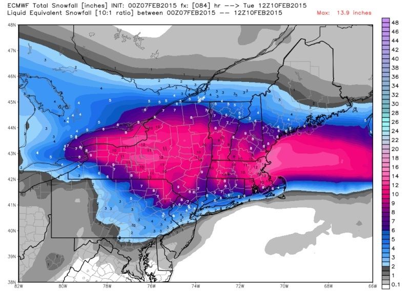
Pay particular attention to the trough spinning over the Alaskan/Canadian boarder. It is in a crappy location. The result is to increase heights in western Canada which in turn forces the PV to sit in a position NE of the Hudson Bay. This essentially forces the Acrtic boundary to initially set up over or maybe just S of LI for Sat and Sunday which leads to very low QPF amounts and an initial increase in surface and mid layer temps associated with the first wave and early in the second wave. But also look to the NW Atlantic. There is a decent looking E based -NAO pushing towards Greenland. The trough over the Alaskan/Canadian Boarder is forecast to drift SW then West and end up just south of the Western Aleutian Islands over the next 24-48hrs. At the same time an ULL is forecast to develop to the south off the West coast near the US/Canadian border that will cause a brief spike in the western ridge. This same ULL/Trough feature off th west coast has a fairly potent 250mb jet streak on its heals which will move it onshore rather quickly and cause the ridge to buckle rather quickly. For me there is a window here when the trough over Alaska backs up to the west which will allow the PV to drift back west and maybe south a bit which will allow the arctic air to press a little further south as we go into Early Monday morning when compared to what is modeled. I think this means we will see totals slowly shift south.
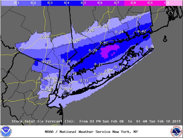
Ice will be a concern in the areas I have outlined. How much or how little will prob need to be ironed out as a nowcast due to the uncertainty of just how far south the frontal boundary actually makes it and the timing of that with the developing main LP to our W on Monday. Here is the NWS Upton snow totals yesterday and then again this morning followed by my first call map. As you can see with todays NWS map there are some pretty sharp cuttoffs. 4-6" to <1" in 10miles..yikes! They are def picking up on the south trend but I think they continue to correct to what my map shows as we go into tomorrow and Monday. Again this is a first call map. This may change.
 " />
" /> " />
" /> " />
" />_________________
"In weather and in life, there's no winning and losing; there's only winning and learning."
WINTER 2012/2013 TOTALS 43.65"WINTER 2017/2018 TOTALS 62.85" WINTER 2022/2023 TOTALS 4.9"
WINTER 2013/2014 TOTALS 64.85"WINTER 2018/2019 TOTALS 14.25" WINTER 2023/2024 TOTALS 13.1"
WINTER 2014/2015 TOTALS 71.20"WINTER 2019/2020 TOTALS 6.35"
WINTER 2015/2016 TOTALS 35.00"WINTER 2020/2021 TOTALS 37.75"
WINTER 2016/2017 TOTALS 42.25"WINTER 2021/2022 TOTALS 31.65"

sroc4- Admin
- Posts : 8331
Reputation : 301
Join date : 2013-01-07
Location : Wading River, LI
Re: UPDATE #2: 1st Call Snow Map, N&W Wins Again
![]() by docstox12 Sat Feb 07, 2015 7:53 am
by docstox12 Sat Feb 07, 2015 7:53 am
I checked NWS for my old town Mahwah and they mention little snow while 25 miles north where I am now they have 4 to 6.Still, the WSW moved south from way upstate NY to now include Orange County.The march south continues.Let's see during nowcast Sunday night and Monday if that analysis above plays out and the heavier snow line drifts south.
Another interesting nowcast situation!
Anyhoo, another very cold week ahead of this storm! When the day comes it hits 50 degrees, we will be in shorts and tee shirts,LOL!

docstox12- Wx Statistician Guru

- Posts : 8507
Reputation : 222
Join date : 2013-01-07
Age : 73
Location : Monroe NY
Re: UPDATE #2: 1st Call Snow Map, N&W Wins Again
![]() by rb924119 Sat Feb 07, 2015 8:18 am
by rb924119 Sat Feb 07, 2015 8:18 am
rb924119- Meteorologist

- Posts : 6890
Reputation : 194
Join date : 2013-02-06
Age : 32
Location : Greentown, Pa
Re: UPDATE #2: 1st Call Snow Map, N&W Wins Again
![]() by jmanley32 Sat Feb 07, 2015 8:55 am
by jmanley32 Sat Feb 07, 2015 8:55 am
jmanley32- Senior Enthusiast
- Posts : 20517
Reputation : 108
Join date : 2013-12-12
Age : 42
Location : Yonkers, NY
Re: UPDATE #2: 1st Call Snow Map, N&W Wins Again
![]() by jmanley32 Sat Feb 07, 2015 8:59 am
by jmanley32 Sat Feb 07, 2015 8:59 am
DAYS TWO THROUGH SEVEN...SUNDAY THROUGH FRIDAY.
A LONG DURATION WINTER WEATHER EVENT IS LIKELY FROM SUNDAY
AFTERNOON INTO LATE MONDAY NIGHT. AT THIS TIME IT APPEARS THAT
THE REGION COULD HAVE FREEZING RAIN ALONG WITH MINOR SNOW
ACCUMULATIONS THAT WOULD CAUSE SIGNIFICANT TRAVEL PROBLEMS.
.SPOTTER INFORMATION STATEMENT...
SPOTTER ACTIVATION WILL LIKELY BE NEEDED.
jmanley32- Senior Enthusiast
- Posts : 20517
Reputation : 108
Join date : 2013-12-12
Age : 42
Location : Yonkers, NY
Re: UPDATE #2: 1st Call Snow Map, N&W Wins Again
![]() by CPcantmeasuresnow Sat Feb 07, 2015 9:00 am
by CPcantmeasuresnow Sat Feb 07, 2015 9:00 am
Last edited by CPcantmeasuresnow on Sat Feb 07, 2015 9:02 am; edited 1 time in total

CPcantmeasuresnow- Wx Statistician Guru
- Posts : 7274
Reputation : 230
Join date : 2013-01-07
Age : 103
Location : Eastern Orange County, NY
Re: UPDATE #2: 1st Call Snow Map, N&W Wins Again
![]() by rb924119 Sat Feb 07, 2015 9:01 am
by rb924119 Sat Feb 07, 2015 9:01 am
rb924119- Meteorologist
- Posts : 6890
Reputation : 194
Join date : 2013-02-06
Age : 32
Location : Greentown, Pa
jmanley32- Senior Enthusiast
- Posts : 20517
Reputation : 108
Join date : 2013-12-12
Age : 42
Location : Yonkers, NY
Re: UPDATE #2: 1st Call Snow Map, N&W Wins Again
![]() by rb924119 Sat Feb 07, 2015 9:05 am
by rb924119 Sat Feb 07, 2015 9:05 am
rb924119- Meteorologist
- Posts : 6890
Reputation : 194
Join date : 2013-02-06
Age : 32
Location : Greentown, Pa
Re: UPDATE #2: 1st Call Snow Map, N&W Wins Again
![]() by rb924119 Sat Feb 07, 2015 9:11 am
by rb924119 Sat Feb 07, 2015 9:11 am
Here's the postage stamps and mean (bottom right) for right now:
http://mp1.met.psu.edu/~fxg1/SREF21PRSNE_9z/f06.gif
Note how the only member that has the current precipitation shield modeled well is the second one in from the right in the middle row.
Here's the QPF map. Take a look lol
http://mp1.met.psu.edu/~fxg1/SREF21PCNTOTNE_9z/f87.gif
rb924119- Meteorologist
- Posts : 6890
Reputation : 194
Join date : 2013-02-06
Age : 32
Location : Greentown, Pa
Re: UPDATE #2: 1st Call Snow Map, N&W Wins Again
![]() by weatherwatchermom Sat Feb 07, 2015 9:16 am
by weatherwatchermom Sat Feb 07, 2015 9:16 am

weatherwatchermom- Senior Enthusiast
- Posts : 3750
Reputation : 77
Join date : 2014-11-25
Age : 60
Location : Hazlet Township, NJ
Re: UPDATE #2: 1st Call Snow Map, N&W Wins Again
![]() by rb924119 Sat Feb 07, 2015 9:31 am
by rb924119 Sat Feb 07, 2015 9:31 am
rb924119- Meteorologist
- Posts : 6890
Reputation : 194
Join date : 2013-02-06
Age : 32
Location : Greentown, Pa
Re: UPDATE #2: 1st Call Snow Map, N&W Wins Again
![]() by rb924119 Sat Feb 07, 2015 9:36 am
by rb924119 Sat Feb 07, 2015 9:36 am
rb924119- Meteorologist
- Posts : 6890
Reputation : 194
Join date : 2013-02-06
Age : 32
Location : Greentown, Pa
Re: UPDATE #2: 1st Call Snow Map, N&W Wins Again
![]() by jimv45 Sat Feb 07, 2015 9:52 am
by jimv45 Sat Feb 07, 2015 9:52 am
jimv45- Senior Enthusiast
- Posts : 1168
Reputation : 36
Join date : 2013-09-20
Location : Hopewell jct.
Re: UPDATE #2: 1st Call Snow Map, N&W Wins Again
![]() by Frank_Wx Sat Feb 07, 2015 9:53 am
by Frank_Wx Sat Feb 07, 2015 9:53 am
_________________
_______________________________________________________________________________________________________
CLICK HERE to view NJ Strong Snowstorm Classifications
Frank_Wx- Godzilla Seeker
- Posts : 21305
Reputation : 328
Join date : 2013-01-05
Age : 31
Location : Jersey City, NJ -
Re: UPDATE #2: 1st Call Snow Map, N&W Wins Again
![]() by rb924119 Sat Feb 07, 2015 10:05 am
by rb924119 Sat Feb 07, 2015 10:05 am
Frank_Wx wrote:The 12z which model rb?
Heyyyyyyyy WAIT A MINUTEEEEEE that's not what I typed!!! LMAO Did you change that??
rb924119- Meteorologist
- Posts : 6890
Reputation : 194
Join date : 2013-02-06
Age : 32
Location : Greentown, Pa
Page 1 of 6 • 1, 2, 3, 4, 5, 6 ![]()
|
|
|