
 Search
Sunday Night-Monday Snow Event
Page 1 of 10 • 1, 2, 3, 4, 5, 6, 7, 8, 9, 10 ![]()

Sunday Night-Monday Snow Event
![]() by Frank_Wx Thu Feb 26, 2015 7:09 pm
by Frank_Wx Thu Feb 26, 2015 7:09 pm

If you look at where we are in the eastern US, we are wedged between a southeast ridge and the PV to our north. For the last couple of days models have been showing a storm track to our north resulting in warmer temps for the storm early next week. The recent trend, however, is calling for CAD (cold air damming) event. Due to the strong amplification of the -EPO, we are seeing the PV get further south and allow the cold to hang around over our area longer. Where the baroclinic zone sets up is where the best VV's will be.

The GFS shows substantial snow for our area early Monday morning.

The euro is a little warmer but still brings snow.
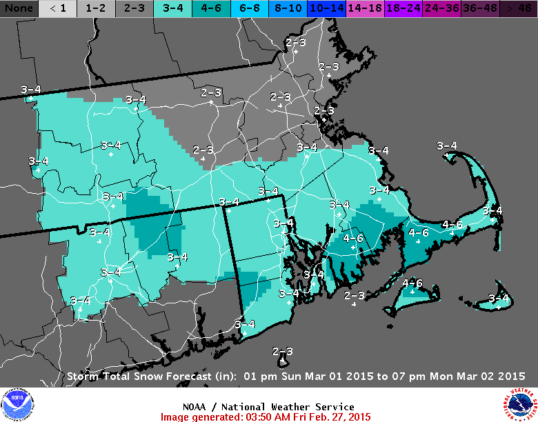
I'll monitor the upper level trends and continue to keep you all in the loop. A 1st call snow map may even be issued as early as tomorrow afternoon. My initial thoughts are a 2-4 inch snowfall area wide.
Stay tuned.
_________________
_______________________________________________________________________________________________________
CLICK HERE to view NJ Strong Snowstorm Classifications

Frank_Wx- Godzilla Seeker

- Posts : 21305
Reputation : 328
Join date : 2013-01-05
Age : 31
Location : Jersey City, NJ -

Re: Sunday Night-Monday Snow Event
![]() by aiannone Thu Feb 26, 2015 7:12 pm
by aiannone Thu Feb 26, 2015 7:12 pm
http://videowall.accuweather.com/detail/videos/current-weather-news/video/3901417444001/snow-to-spread-from-chicago-to?autoStart=true
_________________
-Alex Iannone-

aiannone- Senior Enthusiast - Mod

- Posts : 4814
Reputation : 92
Join date : 2013-01-07
Location : Saint James, LI (Northwest Suffolk Co.)
Re: Sunday Night-Monday Snow Event
![]() by Frank_Wx Thu Feb 26, 2015 7:15 pm
by Frank_Wx Thu Feb 26, 2015 7:15 pm

_________________
_______________________________________________________________________________________________________
CLICK HERE to view NJ Strong Snowstorm Classifications
Frank_Wx- Godzilla Seeker
- Posts : 21305
Reputation : 328
Join date : 2013-01-05
Age : 31
Location : Jersey City, NJ -
Re: Sunday Night-Monday Snow Event
![]() by Frank_Wx Thu Feb 26, 2015 8:59 pm
by Frank_Wx Thu Feb 26, 2015 8:59 pm


_________________
_______________________________________________________________________________________________________
CLICK HERE to view NJ Strong Snowstorm Classifications
Frank_Wx- Godzilla Seeker
- Posts : 21305
Reputation : 328
Join date : 2013-01-05
Age : 31
Location : Jersey City, NJ -
Re: Sunday Night-Monday Snow Event
![]() by Frank_Wx Thu Feb 26, 2015 9:54 pm
by Frank_Wx Thu Feb 26, 2015 9:54 pm


_________________
_______________________________________________________________________________________________________
CLICK HERE to view NJ Strong Snowstorm Classifications
Frank_Wx- Godzilla Seeker
- Posts : 21305
Reputation : 328
Join date : 2013-01-05
Age : 31
Location : Jersey City, NJ -
Re: Sunday Night-Monday Snow Event
![]() by Guest Thu Feb 26, 2015 10:03 pm
by Guest Thu Feb 26, 2015 10:03 pm
Guest- Guest
Re: Sunday Night-Monday Snow Event
![]() by jmanley32 Fri Feb 27, 2015 9:35 am
by jmanley32 Fri Feb 27, 2015 9:35 am

jmanley32- Senior Enthusiast

- Posts : 20517
Reputation : 108
Join date : 2013-12-12
Age : 42
Location : Yonkers, NY
Re: Sunday Night-Monday Snow Event
![]() by aiannone Fri Feb 27, 2015 9:39 am
by aiannone Fri Feb 27, 2015 9:39 am
6z GFS isn't all rain. It's about 2-4" for NYC, 4-5" northward
_________________
-Alex Iannone-
aiannone- Senior Enthusiast - Mod
- Posts : 4814
Reputation : 92
Join date : 2013-01-07
Location : Saint James, LI (Northwest Suffolk Co.)
Re: Sunday Night-Monday Snow Event
![]() by jmanley32 Fri Feb 27, 2015 9:40 am
by jmanley32 Fri Feb 27, 2015 9:40 am
jmanley32- Senior Enthusiast
- Posts : 20517
Reputation : 108
Join date : 2013-12-12
Age : 42
Location : Yonkers, NY
Re: Sunday Night-Monday Snow Event
![]() by CPcantmeasuresnow Fri Feb 27, 2015 9:42 am
by CPcantmeasuresnow Fri Feb 27, 2015 9:42 am
jmanley32 wrote:06z GFS has almost all rain even well inland with this threat. That seems a bit off from the other model runs, thoughts?
I'm not seeing that.
Surface and mid levels seem to support snow for everything north of NYC and even NYC pretty much all snow.

CPcantmeasuresnow- Wx Statistician Guru

- Posts : 7274
Reputation : 230
Join date : 2013-01-07
Age : 103
Location : Eastern Orange County, NY
Re: Sunday Night-Monday Snow Event
![]() by jmanley32 Fri Feb 27, 2015 9:42 am
by jmanley32 Fri Feb 27, 2015 9:42 am

breakdown of p-types, almost no frozen except far NW
jmanley32- Senior Enthusiast
- Posts : 20517
Reputation : 108
Join date : 2013-12-12
Age : 42
Location : Yonkers, NY
Re: Sunday Night-Monday Snow Event
![]() by docstox12 Fri Feb 27, 2015 9:47 am
by docstox12 Fri Feb 27, 2015 9:47 am

docstox12- Wx Statistician Guru
- Posts : 8507
Reputation : 222
Join date : 2013-01-07
Age : 73
Location : Monroe NY
Re: Sunday Night-Monday Snow Event
![]() by aiannone Fri Feb 27, 2015 9:49 am
by aiannone Fri Feb 27, 2015 9:49 am
_________________
-Alex Iannone-
aiannone- Senior Enthusiast - Mod
- Posts : 4814
Reputation : 92
Join date : 2013-01-07
Location : Saint James, LI (Northwest Suffolk Co.)
Re: Sunday Night-Monday Snow Event
![]() by algae888 Fri Feb 27, 2015 10:34 am
by algae888 Fri Feb 27, 2015 10:34 am

algae888- Advanced Forecaster

- Posts : 5311
Reputation : 46
Join date : 2013-02-05
Age : 61
Location : mt. vernon, new york
Re: Sunday Night-Monday Snow Event
![]() by jmanley32 Fri Feb 27, 2015 10:39 am
by jmanley32 Fri Feb 27, 2015 10:39 am
jmanley32- Senior Enthusiast
- Posts : 20517
Reputation : 108
Join date : 2013-12-12
Age : 42
Location : Yonkers, NY
Re: Sunday Night-Monday Snow Event
![]() by jmanley32 Fri Feb 27, 2015 10:42 am
by jmanley32 Fri Feb 27, 2015 10:42 am
jmanley32- Senior Enthusiast
- Posts : 20517
Reputation : 108
Join date : 2013-12-12
Age : 42
Location : Yonkers, NY
Re: Sunday Night-Monday Snow Event
![]() by Frank_Wx Fri Feb 27, 2015 10:52 am
by Frank_Wx Fri Feb 27, 2015 10:52 am


Decent amount of snow and a pretty wet run from the GFS
_________________
_______________________________________________________________________________________________________
CLICK HERE to view NJ Strong Snowstorm Classifications
Frank_Wx- Godzilla Seeker
- Posts : 21305
Reputation : 328
Join date : 2013-01-05
Age : 31
Location : Jersey City, NJ -
Re: Sunday Night-Monday Snow Event
![]() by Frank_Wx Fri Feb 27, 2015 10:55 am
by Frank_Wx Fri Feb 27, 2015 10:55 am

_________________
_______________________________________________________________________________________________________
CLICK HERE to view NJ Strong Snowstorm Classifications
Frank_Wx- Godzilla Seeker
- Posts : 21305
Reputation : 328
Join date : 2013-01-05
Age : 31
Location : Jersey City, NJ -
Re: Sunday Night-Monday Snow Event
![]() by algae888 Fri Feb 27, 2015 11:02 am
by algae888 Fri Feb 27, 2015 11:02 am
algae888- Advanced Forecaster
- Posts : 5311
Reputation : 46
Join date : 2013-02-05
Age : 61
Location : mt. vernon, new york
Re: Sunday Night-Monday Snow Event
![]() by aiannone Fri Feb 27, 2015 11:10 am
by aiannone Fri Feb 27, 2015 11:10 am
_________________
-Alex Iannone-
aiannone- Senior Enthusiast - Mod
- Posts : 4814
Reputation : 92
Join date : 2013-01-07
Location : Saint James, LI (Northwest Suffolk Co.)
Re: Sunday Night-Monday Snow Event
![]() by skinsfan1177 Fri Feb 27, 2015 11:35 am
by skinsfan1177 Fri Feb 27, 2015 11:35 am

skinsfan1177- Senior Enthusiast
- Posts : 4485
Reputation : 35
Join date : 2013-01-07
Age : 46
Location : Point Pleasant Boro
Re: Sunday Night-Monday Snow Event
![]() by jmanley32 Fri Feb 27, 2015 11:36 am
by jmanley32 Fri Feb 27, 2015 11:36 am

jmanley32- Senior Enthusiast
- Posts : 20517
Reputation : 108
Join date : 2013-12-12
Age : 42
Location : Yonkers, NY
Re: Sunday Night-Monday Snow Event
![]() by jmanley32 Fri Feb 27, 2015 11:40 am
by jmanley32 Fri Feb 27, 2015 11:40 am
jmanley32- Senior Enthusiast
- Posts : 20517
Reputation : 108
Join date : 2013-12-12
Age : 42
Location : Yonkers, NY
Re: Sunday Night-Monday Snow Event
![]() by aiannone Fri Feb 27, 2015 12:00 pm
by aiannone Fri Feb 27, 2015 12:00 pm
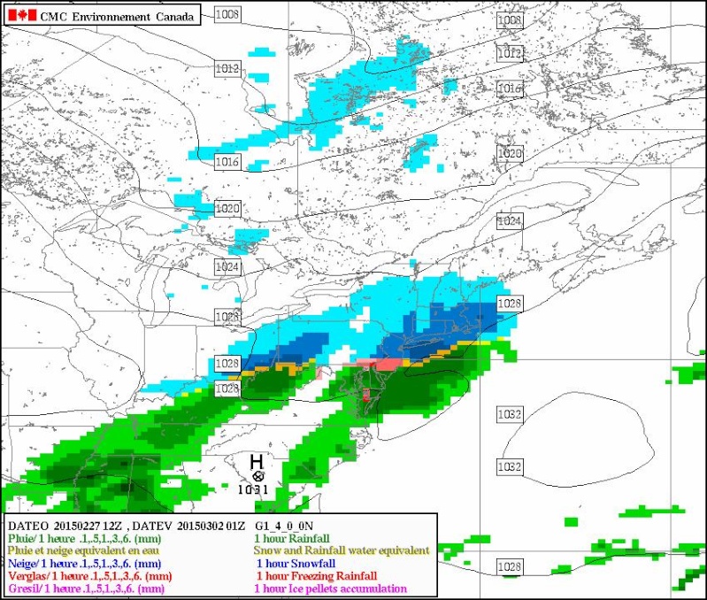
jmanley32 wrote:CMC came in with much less qpf, 2-4 inches in NYC, NW 1-3.
CMC is very cold though. Little better ratios
_________________
-Alex Iannone-
aiannone- Senior Enthusiast - Mod
- Posts : 4814
Reputation : 92
Join date : 2013-01-07
Location : Saint James, LI (Northwest Suffolk Co.)
Re: Sunday Night-Monday Snow Event
![]() by aiannone Fri Feb 27, 2015 12:02 pm
by aiannone Fri Feb 27, 2015 12:02 pm
_________________
-Alex Iannone-
aiannone- Senior Enthusiast - Mod
- Posts : 4814
Reputation : 92
Join date : 2013-01-07
Location : Saint James, LI (Northwest Suffolk Co.)
Page 1 of 10 • 1, 2, 3, 4, 5, 6, 7, 8, 9, 10 ![]()
|
|
|