
 Search
Impact Map / Observations Thread - Tuesday Snow&Ice Event
Page 8 of 8 •  1, 2, 3, 4, 5, 6, 7, 8
Re: Impact Map / Observations Thread - Tuesday Snow&Ice Event
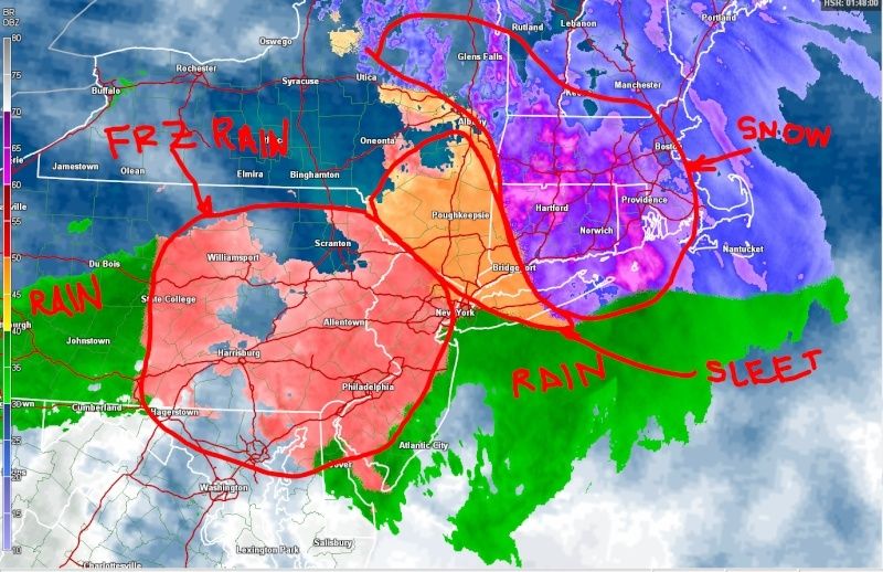
![]() by jmanley32 Tue Mar 03, 2015 8:07 pm
by jmanley32 Tue Mar 03, 2015 8:07 pm
jmanley32- Senior Enthusiast

- Posts : 20517
Join date : 2013-12-12
Re: Impact Map / Observations Thread - Tuesday Snow&Ice Event
![]() by amugs Tue Mar 03, 2015 8:17 pm
by amugs Tue Mar 03, 2015 8:17 pm
How about by you?
amugs- Advanced Forecaster - Mod

- Posts : 15093
Join date : 2013-01-07
Re: Impact Map / Observations Thread - Tuesday Snow&Ice Event
![]() by Dunnzoo Tue Mar 03, 2015 8:19 pm
by Dunnzoo Tue Mar 03, 2015 8:19 pm
_________________
Janet
Snowfall winter of 2023-2024 17.5"
Snowfall winter of 2022-2023 6.0"
Snowfall winter of 2021-2022 17.6" 1" sleet 2/25/22
Snowfall winter of 2020-2021 51.1"
Snowfall winter of 2019-2020 8.5"
Snowfall winter of 2018-2019 25.1"
Snowfall winter of 2017-2018 51.9"
Snowfall winter of 2016-2017 45.6"
Snowfall winter of 2015-2016 29.5"
Snowfall winter of 2014-2015 50.55"
Snowfall winter of 2013-2014 66.5"

Dunnzoo- Senior Enthusiast - Mod
- Posts : 4892
Reputation : 68
Join date : 2013-01-11
Age : 62
Location : Westwood, NJ
Re: Impact Map / Observations Thread - Tuesday Snow&Ice Event
![]() by SoulSingMG Tue Mar 03, 2015 8:27 pm
by SoulSingMG Tue Mar 03, 2015 8:27 pm

SoulSingMG- Senior Enthusiast
- Posts : 2853
Reputation : 74
Join date : 2013-12-11
Location : Long Island City, NY
Re: Impact Map / Observations Thread - Tuesday Snow&Ice Event
![]() by RJB8525 Tue Mar 03, 2015 8:29 pm
by RJB8525 Tue Mar 03, 2015 8:29 pm

RJB8525- Senior Enthusiast
- Posts : 1994
Reputation : 28
Join date : 2013-02-06
Age : 38
Location : Hackettstown, NJ
Re: Impact Map / Observations Thread - Tuesday Snow&Ice Event
![]() by snow247 Tue Mar 03, 2015 8:30 pm
by snow247 Tue Mar 03, 2015 8:30 pm
I don't want plain rain.

snow247- Pro Enthusiast

- Posts : 2417
Reputation : 0
Join date : 2014-08-27
Location : Mount Ivy, NY - Elevation 545'
Re: Impact Map / Observations Thread - Tuesday Snow&Ice Event
![]() by algae888 Tue Mar 03, 2015 8:41 pm
by algae888 Tue Mar 03, 2015 8:41 pm

algae888- Advanced Forecaster

- Posts : 5311
Reputation : 46
Join date : 2013-02-05
Age : 61
Location : mt. vernon, new york
Re: Impact Map / Observations Thread - Tuesday Snow&Ice Event
![]() by Dunnzoo Tue Mar 03, 2015 8:44 pm
by Dunnzoo Tue Mar 03, 2015 8:44 pm
_________________
Janet
Snowfall winter of 2023-2024 17.5"
Snowfall winter of 2022-2023 6.0"
Snowfall winter of 2021-2022 17.6" 1" sleet 2/25/22
Snowfall winter of 2020-2021 51.1"
Snowfall winter of 2019-2020 8.5"
Snowfall winter of 2018-2019 25.1"
Snowfall winter of 2017-2018 51.9"
Snowfall winter of 2016-2017 45.6"
Snowfall winter of 2015-2016 29.5"
Snowfall winter of 2014-2015 50.55"
Snowfall winter of 2013-2014 66.5"
Dunnzoo- Senior Enthusiast - Mod
- Posts : 4892
Reputation : 68
Join date : 2013-01-11
Age : 62
Location : Westwood, NJ
Re: Impact Map / Observations Thread - Tuesday Snow&Ice Event
![]() by jmanley32 Tue Mar 03, 2015 8:46 pm
by jmanley32 Tue Mar 03, 2015 8:46 pm

jmanley32- Senior Enthusiast
- Posts : 20517
Reputation : 108
Join date : 2013-12-12
Age : 42
Location : Yonkers, NY
Re: Impact Map / Observations Thread - Tuesday Snow&Ice Event
![]() by SNOW MAN Tue Mar 03, 2015 8:47 pm
by SNOW MAN Tue Mar 03, 2015 8:47 pm
CPcantmeasuresnow wrote:hyde345 wrote:jimv45 wrote:boy Hyde sleeting up here thought is was going to snow for a while?
Yeah, it changed to sleet earlier than I thought for sure. It's absolutely ripping sleet right now. It's going to be a bitch to shovel tomorrow.
I don't know if you guys are old enough to remember the march 1993 storm. 17 inches of snow followed by 3 inches of sleet. This reminds me of the sleet part of that storm.
I remember that one. I think they called it the Super storm of 93 on TWC.

SNOW MAN- Senior Enthusiast
- Posts : 1361
Reputation : 25
Join date : 2013-01-13
Age : 64
Location : Marshalls Creek Pa.
Re: Impact Map / Observations Thread - Tuesday Snow&Ice Event
![]() by hyde345 Tue Mar 03, 2015 8:51 pm
by hyde345 Tue Mar 03, 2015 8:51 pm
CPcantmeasuresnow wrote:hyde345 wrote:jimv45 wrote:boy Hyde sleeting up here thought is was going to snow for a while?
Yeah, it changed to sleet earlier than I thought for sure. It's absolutely ripping sleet right now. It's going to be a bitch to shovel tomorrow.
I don't know if you guys are old enough to remember the march 1993 storm. 17 inches of snow followed by 3 inches of sleet. This reminds me of the sleet part of that storm.
CP, I remember that storm like it was yesterday, crazy.

hyde345- Pro Enthusiast
- Posts : 1082
Reputation : 48
Join date : 2013-01-08
Location : Hyde Park, NY
Re: Impact Map / Observations Thread - Tuesday Snow&Ice Event
![]() by SNOW MAN Tue Mar 03, 2015 8:53 pm
by SNOW MAN Tue Mar 03, 2015 8:53 pm
SNOW MAN- Senior Enthusiast
- Posts : 1361
Reputation : 25
Join date : 2013-01-13
Age : 64
Location : Marshalls Creek Pa.
Re: Impact Map / Observations Thread - Tuesday Snow&Ice Event
![]() by Joe Snow Tue Mar 03, 2015 8:55 pm
by Joe Snow Tue Mar 03, 2015 8:55 pm
Latest Radar.......

Joe Snow- Pro Enthusiast
- Posts : 924
Reputation : 7
Join date : 2014-02-12
Age : 62
Location : Sanford Florida, Fmrly Kings Park, NY
Re: Impact Map / Observations Thread - Tuesday Snow&Ice Event
![]() by amugs Tue Mar 03, 2015 9:00 pm
by amugs Tue Mar 03, 2015 9:00 pm
_________________
Mugs
AKA:King: Snow Weenie
Self Proclaimed
WINTER 2014-15 : 55.12" +.02 for 6 coatings (avg. 35")
WINTER 2015-16 Total - 29.8" (Avg 35")
WINTER 2016-17 : 39.5" so far

amugs- Advanced Forecaster - Mod
- Posts : 15093
Reputation : 213
Join date : 2013-01-07
Age : 54
Location : Hillsdale,NJ
Re: Impact Map / Observations Thread - Tuesday Snow&Ice Event
![]() by NjWeatherGuy Tue Mar 03, 2015 9:00 pm
by NjWeatherGuy Tue Mar 03, 2015 9:00 pm

NjWeatherGuy- Advanced Forecaster
- Posts : 4100
Reputation : 28
Join date : 2013-01-06
Location : Belle Mead, NJ
Re: Impact Map / Observations Thread - Tuesday Snow&Ice Event
![]() by CPcantmeasuresnow Tue Mar 03, 2015 9:03 pm
by CPcantmeasuresnow Tue Mar 03, 2015 9:03 pm
27.7 here and still moderate to heavy sleet.
3.3 inches of combined snow and sleet so far.

CPcantmeasuresnow- Wx Statistician Guru

- Posts : 7274
Reputation : 230
Join date : 2013-01-07
Age : 103
Location : Eastern Orange County, NY
Re: Impact Map / Observations Thread - Tuesday Snow&Ice Event
![]() by snow247 Tue Mar 03, 2015 9:44 pm
by snow247 Tue Mar 03, 2015 9:44 pm
Bye bye snowpack, it was very nice having you for well over a month.
snow247- Pro Enthusiast
- Posts : 2417
Reputation : 0
Join date : 2014-08-27
Location : Mount Ivy, NY - Elevation 545'
Re: Impact Map / Observations Thread - Tuesday Snow&Ice Event
![]() by Dunnzoo Tue Mar 03, 2015 9:49 pm
by Dunnzoo Tue Mar 03, 2015 9:49 pm
_________________
Janet
Snowfall winter of 2023-2024 17.5"
Snowfall winter of 2022-2023 6.0"
Snowfall winter of 2021-2022 17.6" 1" sleet 2/25/22
Snowfall winter of 2020-2021 51.1"
Snowfall winter of 2019-2020 8.5"
Snowfall winter of 2018-2019 25.1"
Snowfall winter of 2017-2018 51.9"
Snowfall winter of 2016-2017 45.6"
Snowfall winter of 2015-2016 29.5"
Snowfall winter of 2014-2015 50.55"
Snowfall winter of 2013-2014 66.5"
Dunnzoo- Senior Enthusiast - Mod
- Posts : 4892
Reputation : 68
Join date : 2013-01-11
Age : 62
Location : Westwood, NJ
Re: Impact Map / Observations Thread - Tuesday Snow&Ice Event
![]() by snow247 Tue Mar 03, 2015 9:57 pm
by snow247 Tue Mar 03, 2015 9:57 pm
snow247- Pro Enthusiast
- Posts : 2417
Reputation : 0
Join date : 2014-08-27
Location : Mount Ivy, NY - Elevation 545'
Re: Impact Map / Observations Thread - Tuesday Snow&Ice Event
![]() by NjWeatherGuy Tue Mar 03, 2015 10:09 pm
by NjWeatherGuy Tue Mar 03, 2015 10:09 pm
NjWeatherGuy- Advanced Forecaster
- Posts : 4100
Reputation : 28
Join date : 2013-01-06
Location : Belle Mead, NJ
Re: Impact Map / Observations Thread - Tuesday Snow&Ice Event
![]() by Frank_Wx Tue Mar 03, 2015 10:18 pm
by Frank_Wx Tue Mar 03, 2015 10:18 pm
_________________
_______________________________________________________________________________________________________
CLICK HERE to view NJ Strong Snowstorm Classifications

Frank_Wx- Godzilla Seeker

- Posts : 21305
Reputation : 328
Join date : 2013-01-05
Age : 31
Location : Jersey City, NJ -

Re: Impact Map / Observations Thread - Tuesday Snow&Ice Event
![]() by amugs Tue Mar 03, 2015 10:28 pm
by amugs Tue Mar 03, 2015 10:28 pm
_________________
Mugs
AKA:King: Snow Weenie
Self Proclaimed
WINTER 2014-15 : 55.12" +.02 for 6 coatings (avg. 35")
WINTER 2015-16 Total - 29.8" (Avg 35")
WINTER 2016-17 : 39.5" so far
amugs- Advanced Forecaster - Mod
- Posts : 15093
Reputation : 213
Join date : 2013-01-07
Age : 54
Location : Hillsdale,NJ
Re: Impact Map / Observations Thread - Tuesday Snow&Ice Event
![]() by keliza52 Tue Mar 03, 2015 10:38 pm
by keliza52 Tue Mar 03, 2015 10:38 pm
Karen

keliza52- Posts : 51
Reputation : 0
Join date : 2013-12-08
Location : Hackettstown, NJ
Re: Impact Map / Observations Thread - Tuesday Snow&Ice Event
![]() by Guest Wed Mar 04, 2015 9:03 am
by Guest Wed Mar 04, 2015 9:03 am
On and off light rain here on NS of LI 36 degrees. Hoping it doesn't get much warmer so changeover happens earlier. 2 things to look for IMO
1. The radar over Tennessee and Kentucky looks really good and looks to be heading this way.
2. This cold front is really strong. We will be achieving record low temperatures Thursday night. Is the arctic air too strong and therefore forces the precip. south??
I'll take the 4 to 8" forecast right now and run. Thinking more along the lines of 4 to 6" here for me. Neutral Neutral
Guest- Guest
Sponsored content
Page 8 of 8 • 1, 2, 3, 4, 5, 6, 7, 8
|
|
|