
 Search
Long Range Thread 8.0
Page 18 of 40 •  1 ... 10 ... 17, 18, 19 ... 29 ... 40
 ![]()


rb924119- Meteorologist

- Posts : 6889
Join date : 2013-02-06
Re: Long Range Thread 8.0
![]() by amugs Wed Oct 07, 2015 3:10 pm
by amugs Wed Oct 07, 2015 3:10 pm


Anyway, now that it looks like we have the pattern what will happen to that ULL the GFS and EURO are showing coming out of the tropics region? Hope we can capture that in this pattern.
amugs- Advanced Forecaster - Mod

- Posts : 15093
Join date : 2013-01-07
Re: Long Range Thread 8.0
![]() by rb924119 Wed Oct 07, 2015 4:07 pm
by rb924119 Wed Oct 07, 2015 4:07 pm
amugs wrote:Rb^^^^^ that is impressive - again give me this come Jan and Feb and I will........................
Anyway, now that it looks like we have the pattern what will happen to that ULL the GFS and EURO are showing coming out of the tropics region? Hope we can capture that in this pattern.
I'm not sure of which one you mean, but all I want to add is this:
MJO is starting to gain influence now as we head into deeper into Fall and towards Winter. The first two maps I posted are ~days 6 and 10. Check how it corresponds to this....Just sayin'

For reference, each black dot along the green line (ensemble mean) represents a forecast day (e.g. the 10th black dot in numerical order from the start of the green line is day 10, etc.)
rb924119- Meteorologist
- Posts : 6889
Reputation : 194
Join date : 2013-02-06
Age : 32
Location : Greentown, Pa
Re: Long Range Thread 8.0
![]() by skinsfan1177 Wed Oct 07, 2015 4:10 pm
by skinsfan1177 Wed Oct 07, 2015 4:10 pm

skinsfan1177- Senior Enthusiast

- Posts : 4485
Reputation : 35
Join date : 2013-01-07
Age : 46
Location : Point Pleasant Boro
Re: Long Range Thread 8.0
![]() by amugs Wed Oct 07, 2015 4:21 pm
by amugs Wed Oct 07, 2015 4:21 pm
Skins, basin wide nino means the warm waters are spread out over a larger area and not concentrated on the eastern pacific off the coast of South america. If they were concentrateed in this area we call region 1.2 then what happens is the stj and warm air is so close to us we torch and rain Ala 1997-98 winter or winter that wasn't.
We spray out the warmth we have a big area of warmth that is not concentrated near us thus allowing for the stj - sub tropical jet- to come to us but not overpower us. It would also allow other mechanisms in the atmosphere to occur by having a basin wide nino or Modaki Nino like the PNA and EPO to be more favorable thus negative to neutral epo amd positive pna. This helps us up here get the storms that the stj will help form on along its path.
Now if we get a western based concentrated nino, like what might occur, then the stj forcing us furthest away and will allow the other atmospheric mechanisms to help like the epo and pna and still bring a slight of moisture for storms to coccur, Ala 2002-03.
Super nino just means a strong nino that is above +2 Celsius , the ocean temps compared to its normal temperature as the maps we have been posting.
If I am mistaken in my discussion here please correct me and I will learn too buy this is the extent of my knowledge on this.
I hope this helps skins.
Last edited by amugs on Wed Oct 07, 2015 4:55 pm; edited 1 time in total
_________________
Mugs
AKA:King: Snow Weenie
Self Proclaimed
WINTER 2014-15 : 55.12" +.02 for 6 coatings (avg. 35")
WINTER 2015-16 Total - 29.8" (Avg 35")
WINTER 2016-17 : 39.5" so far

amugs- Advanced Forecaster - Mod
- Posts : 15093
Reputation : 213
Join date : 2013-01-07
Age : 54
Location : Hillsdale,NJ
Re: Long Range Thread 8.0
![]() by skinsfan1177 Wed Oct 07, 2015 4:24 pm
by skinsfan1177 Wed Oct 07, 2015 4:24 pm
amugs wrote:skinsfan1177 wrote:Can someone explain please why it's important for basin wide am Nino? Also is it a super or strong El nino? Thank you[/quote
Skins, basin wide nino means the warm waters are spread out over a larger area and not concentrated on the eastern pacific off the coast of South america. If they were concentrateed in this area we call region 1.2 then what happens is the stj and warm air is so close to us we torch and rain Ala 1997-98 winter or winter that wasn't.
We spray out the warmth we have a big area of warmth that is not concentrated near us thus allowing for the stj - sub tropical jet- to come to us but not overpower us. It would also allow other mechanisms in the atmosphere to occur by having a basin wide nino or Modaki Nino like the PNA and EPO to be more favorable thus negative to neutral epo amd positive pna. This helps us up here get the storms that the stj will help form on along its path.
Now if we get a western based concentrated nino, like what might occur, then the stj forcing us furthest away and will allow the other atmospheric mechanisms to help like the epo and pna and still bring a slight of moisture for storms to coccur, Ala 2002-03.
Super nino just means a strong nino that is above +2 Celsius , the ocean temps compared to its normal temperature as the maps we have been posting.
If I am mistaken in my discussion here please correct me and I will learn too buy this is the extent of my knowledge on this.
I hope this helps skins.
Thanks you mugs now I have a understanding and keep up the great work your guys knowledge is great
skinsfan1177- Senior Enthusiast
- Posts : 4485
Reputation : 35
Join date : 2013-01-07
Age : 46
Location : Point Pleasant Boro
Re: Long Range Thread 8.0
![]() by dkodgis Wed Oct 07, 2015 5:20 pm
by dkodgis Wed Oct 07, 2015 5:20 pm
http://nypost.com/2015/10/07/forecasters-predict-milder-winter-for-northeast-due-to-godzilla-el-nino/

dkodgis- Senior Enthusiast
- Posts : 2496
Reputation : 98
Join date : 2013-12-29
Re: Long Range Thread 8.0
![]() by amugs Wed Oct 07, 2015 5:23 pm
by amugs Wed Oct 07, 2015 5:23 pm

_________________
Mugs
AKA:King: Snow Weenie
Self Proclaimed
WINTER 2014-15 : 55.12" +.02 for 6 coatings (avg. 35")
WINTER 2015-16 Total - 29.8" (Avg 35")
WINTER 2016-17 : 39.5" so far
amugs- Advanced Forecaster - Mod
- Posts : 15093
Reputation : 213
Join date : 2013-01-07
Age : 54
Location : Hillsdale,NJ
Re: Long Range Thread 8.0
![]() by amugs Wed Oct 07, 2015 5:25 pm
by amugs Wed Oct 07, 2015 5:25 pm
dkodgis wrote:Accuweather says it may be a mild winter until maybe February and March due to the super El Nino:
http://nypost.com/2015/10/07/forecasters-predict-milder-winter-for-northeast-due-to-godzilla-el-nino/
Here you have it:
“We just don’t know exactly yet whether or not we’re going to see the pattern turn cold and snowy,” AccuWeather long-range forecaster Paul Pastelok said.
What in teh H hedge comment is this - wayyyy tooo early for this forecast IMHO
_________________
Mugs
AKA:King: Snow Weenie
Self Proclaimed
WINTER 2014-15 : 55.12" +.02 for 6 coatings (avg. 35")
WINTER 2015-16 Total - 29.8" (Avg 35")
WINTER 2016-17 : 39.5" so far
amugs- Advanced Forecaster - Mod
- Posts : 15093
Reputation : 213
Join date : 2013-01-07
Age : 54
Location : Hillsdale,NJ
Re: Long Range Thread 8.0
![]() by algae888 Wed Oct 07, 2015 5:57 pm
by algae888 Wed Oct 07, 2015 5:57 pm
this is very good news as inaccu wx is seldom right.dkodgis wrote:Accuweather says it may be a mild winter until maybe February and March due to the super El Nino:
http://nypost.com/2015/10/07/forecasters-predict-milder-winter-for-northeast-due-to-godzilla-el-nino/

algae888- Advanced Forecaster

- Posts : 5311
Reputation : 46
Join date : 2013-02-05
Age : 61
Location : mt. vernon, new york
Re: Long Range Thread 8.0
![]() by sroc4 Wed Oct 07, 2015 7:12 pm
by sroc4 Wed Oct 07, 2015 7:12 pm
dkodgis wrote:Accuweather says it may be a mild winter until maybe February and March due to the super El Nino:
http://nypost.com/2015/10/07/forecasters-predict-milder-winter-for-northeast-due-to-godzilla-el-nino/
I would not read much into this. Accuweather and Paul Pastelok are being taken out of context.
“We just don’t know exactly yet whether or not we’re going to see the pattern turn cold and snowy,” and
“…There is an opportunity that [the weather] could change on us as we get into February and early March.” were not said all in one sentence. If they were then "..." would not precede the second quote. "..." before a quote or in the middle of a quote typically means there was conversation that was omitted. It can be a few words or several paragraphs, but "..." can substitute both when quoting someone. This is a technique commonly used when athletes and movie stars are quoted to generate certain feel to a comment in order to lure the reader down a certain desired path. This is a soap box of mine, that is, the media influencing public opinion.
I mean the first quote is absolutely true right? We dont know if its going to change to cold and snowy yet. Its only October for Gods sake. And the second quote is exactly what happened last year. The wording...as we get into February...is just vague enough to in theory include January because technically January would be the month that would allow us to "get into" Feb. Again the quotes were manipulated to lean a reader down a certain path here about what to expect for this winter.
My point here is that this article is nothing more than the media bending a story to sell their article. I mean look at the title.
"The anomalous weather system is so large, some experts refer to it as a “Godzilla El Niño.” Really???
What experts Yaron Steinbuch? What experts I ask??? Get an expert to go on record for you buddy. Yaron Steinbuch you should be ashamed.
_________________
"In weather and in life, there's no winning and losing; there's only winning and learning."
WINTER 2012/2013 TOTALS 43.65"WINTER 2017/2018 TOTALS 62.85" WINTER 2022/2023 TOTALS 4.9"
WINTER 2013/2014 TOTALS 64.85"WINTER 2018/2019 TOTALS 14.25" WINTER 2023/2024 TOTALS 13.1"
WINTER 2014/2015 TOTALS 71.20"WINTER 2019/2020 TOTALS 6.35"
WINTER 2015/2016 TOTALS 35.00"WINTER 2020/2021 TOTALS 37.75"
WINTER 2016/2017 TOTALS 42.25"WINTER 2021/2022 TOTALS 31.65"

sroc4- Admin

- Posts : 8331
Reputation : 301
Join date : 2013-01-07
Location : Wading River, LI
Re: Long Range Thread 8.0
![]() by Frank_Wx Wed Oct 07, 2015 8:15 pm
by Frank_Wx Wed Oct 07, 2015 8:15 pm
_________________
_______________________________________________________________________________________________________
CLICK HERE to view NJ Strong Snowstorm Classifications

Frank_Wx- Godzilla Seeker
- Posts : 21305
Reputation : 328
Join date : 2013-01-05
Age : 31
Location : Jersey City, NJ -

Re: Long Range Thread 8.0
![]() by HectorO Wed Oct 07, 2015 8:17 pm
by HectorO Wed Oct 07, 2015 8:17 pm
sroc4 wrote:dkodgis wrote:Accuweather says it may be a mild winter until maybe February and March due to the super El Nino:
http://nypost.com/2015/10/07/forecasters-predict-milder-winter-for-northeast-due-to-godzilla-el-nino/
I would not read much into this. Accuweather and Paul Pastelok are being taken out of context.
“We just don’t know exactly yet whether or not we’re going to see the pattern turn cold and snowy,” and
“…There is an opportunity that [the weather] could change on us as we get into February and early March.” were not said all in one sentence. If they were then "..." would not precede the second quote. "..." before a quote or in the middle of a quote typically means there was conversation that was omitted. It can be a few words or several paragraphs, but "..." can substitute both when quoting someone. This is a technique commonly used when athletes and movie stars are quoted to generate certain feel to a comment in order to lure the reader down a certain desired path. This is a soap box of mine, that is, the media influencing public opinion.
I mean the first quote is absolutely true right? We dont know if its going to change to cold and snowy yet. Its only October for Gods sake. And the second quote is exactly what happened last year. The wording...as we get into February...is just vague enough to in theory include January because technically January would be the month that would allow us to "get into" Feb. Again the quotes were manipulated to lean a reader down a certain path here about what to expect for this winter.
My point here is that this article is nothing more than the media bending a story to sell their article. I mean look at the title.
"The anomalous weather system is so large, some experts refer to it as a “Godzilla El Niño.” Really???
What experts Yaron Steinbuch? What experts I ask??? Get an expert to go on record for you buddy. Yaron Steinbuch you should be ashamed.
What a weird thing to say and pretty bad wording. “We just don’t know exactly yet whether or not we’re going to see the pattern turn cold and snowy,” Shouldn't it have been worded " We don't know when the patter is going to start turning cold?" The way he says it is as if he's uncertain if there's going to be any winter or cold weather.

HectorO- Pro Enthusiast

- Posts : 959
Reputation : 27
Join date : 2013-01-11
Re: Long Range Thread 8.0
![]() by algae888 Wed Oct 07, 2015 9:24 pm
by algae888 Wed Oct 07, 2015 9:24 pm

nothing specific. very vague. this is only logical response at this early time.
algae888- Advanced Forecaster
- Posts : 5311
Reputation : 46
Join date : 2013-02-05
Age : 61
Location : mt. vernon, new york
Re: Long Range Thread 8.0
![]() by Frank_Wx Wed Oct 07, 2015 9:31 pm
by Frank_Wx Wed Oct 07, 2015 9:31 pm
_________________
_______________________________________________________________________________________________________
CLICK HERE to view NJ Strong Snowstorm Classifications
Frank_Wx- Godzilla Seeker
- Posts : 21305
Reputation : 328
Join date : 2013-01-05
Age : 31
Location : Jersey City, NJ -
Re: Long Range Thread 8.0
![]() by Dunnzoo Wed Oct 07, 2015 9:34 pm
by Dunnzoo Wed Oct 07, 2015 9:34 pm
Frank_Wx wrote:What's the point of even releasing a map like that? It tell you nothing.
That's one thing that makes me crazy...have a discussion, sure, look at trends, sure.... but putting out maps make people crazy, just like all the Joaquin track maps that were being posted..
_________________
Janet
Snowfall winter of 2023-2024 17.5"
Snowfall winter of 2022-2023 6.0"
Snowfall winter of 2021-2022 17.6" 1" sleet 2/25/22
Snowfall winter of 2020-2021 51.1"
Snowfall winter of 2019-2020 8.5"
Snowfall winter of 2018-2019 25.1"
Snowfall winter of 2017-2018 51.9"
Snowfall winter of 2016-2017 45.6"
Snowfall winter of 2015-2016 29.5"
Snowfall winter of 2014-2015 50.55"
Snowfall winter of 2013-2014 66.5"

Dunnzoo- Senior Enthusiast - Mod
- Posts : 4887
Reputation : 68
Join date : 2013-01-11
Age : 62
Location : Westwood, NJ
Re: Long Range Thread 8.0
![]() by HectorO Wed Oct 07, 2015 11:09 pm
by HectorO Wed Oct 07, 2015 11:09 pm
algae888 wrote:this is what he (pastelok) was trying to say...
nothing specific. very vague. this is only logical response at this early time.
These maps are so useless, especially from accuweather. Last year I think we all posted a link from like 5 years worth of these maps that were way, and I mean way off lol. Especially the one they made for the 2011/2012 one. The very snowy and cold one.
HectorO- Pro Enthusiast
- Posts : 959
Reputation : 27
Join date : 2013-01-11
Re: Long Range Thread 8.0
![]() by HectorO Wed Oct 07, 2015 11:18 pm
by HectorO Wed Oct 07, 2015 11:18 pm
http://www.accuweather.com/en/weather-blogs/anderson/the-20142015-accuweather-winter-forecast-for-canada/36489273 Last years "not supposed to be as cold as the year before....... right.
13/14 Pastelok was just babbling on. Above average temps, but we could see some below average temps. Above average snow, below average snow blah blah.
HectorO- Pro Enthusiast
- Posts : 959
Reputation : 27
Join date : 2013-01-11
Re: Long Range Thread 8.0
![]() by sroc4 Thu Oct 08, 2015 7:08 am
by sroc4 Thu Oct 08, 2015 7:08 am
_________________
"In weather and in life, there's no winning and losing; there's only winning and learning."
WINTER 2012/2013 TOTALS 43.65"WINTER 2017/2018 TOTALS 62.85" WINTER 2022/2023 TOTALS 4.9"
WINTER 2013/2014 TOTALS 64.85"WINTER 2018/2019 TOTALS 14.25" WINTER 2023/2024 TOTALS 13.1"
WINTER 2014/2015 TOTALS 71.20"WINTER 2019/2020 TOTALS 6.35"
WINTER 2015/2016 TOTALS 35.00"WINTER 2020/2021 TOTALS 37.75"
WINTER 2016/2017 TOTALS 42.25"WINTER 2021/2022 TOTALS 31.65"
sroc4- Admin
- Posts : 8331
Reputation : 301
Join date : 2013-01-07
Location : Wading River, LI
Re: Long Range Thread 8.0
![]() by sroc4 Thu Oct 08, 2015 7:54 am
by sroc4 Thu Oct 08, 2015 7:54 am
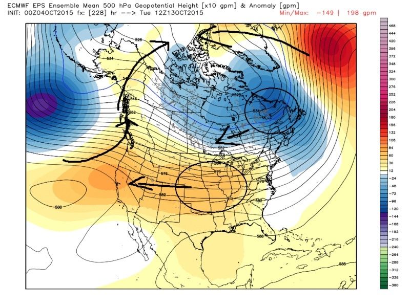 " />
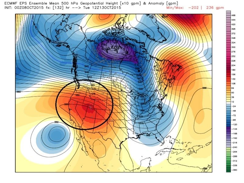
" />Same time frame now only 132 hrs out. Notice how the positives (warm colors) over the plains have pulled back building a positive PNA ridge (https://www.njstrongweatherforum.com/t575-pna-ridge-in-west#66938). Consequently you can see the trough in the east. I thought; however, the positives would build into Alaska( negative EPO) as well, but it looks like negative heights (cool colors) are building into Alaska (positive EPO) instead. This will lead to cooler temps but we still have Pacific air mixing into the equation with this pattern.
 " />
" />Now here is last nights Euro ens again at hr 228. 12z Oct 17th time frame: The same thing should happen. The higher heights over the plains will pull back into the west building the +PNA ridge. I believe; however, there is a much better chance at the ridge also building into Alaska as well as along the west coast. This would shift the axis of the trough back to the west centering it over the eastern third of the nation. The -NAO, warmer colors building into Greenland is a possibility with this look as well. This pattern in turn would bring a cross polar flow into the equation that would lead to even colder temps as Frank is alluding to. He will prob go much more detail on this in the blog he plans to release.
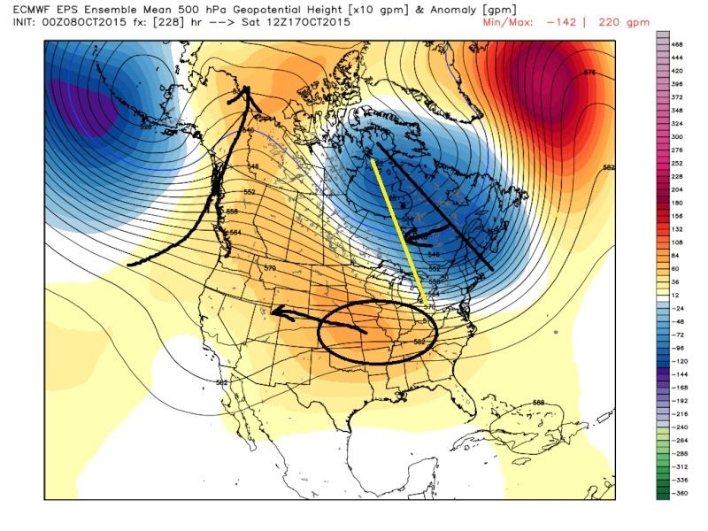 " />
" />Another piece to monitor is the upper level low that has been persistently spinning, currently centered over NW Mexico. It is modeled to retrograde west and meander just off the SE Cali/Baha coast. With its current position it is aiding in our currently warm daytime temps. Look at both time frames I discussed above off the SW coast.

_________________
"In weather and in life, there's no winning and losing; there's only winning and learning."
WINTER 2012/2013 TOTALS 43.65"WINTER 2017/2018 TOTALS 62.85" WINTER 2022/2023 TOTALS 4.9"
WINTER 2013/2014 TOTALS 64.85"WINTER 2018/2019 TOTALS 14.25" WINTER 2023/2024 TOTALS 13.1"
WINTER 2014/2015 TOTALS 71.20"WINTER 2019/2020 TOTALS 6.35"
WINTER 2015/2016 TOTALS 35.00"WINTER 2020/2021 TOTALS 37.75"
WINTER 2016/2017 TOTALS 42.25"WINTER 2021/2022 TOTALS 31.65"
sroc4- Admin
- Posts : 8331
Reputation : 301
Join date : 2013-01-07
Location : Wading River, LI
Re: Long Range Thread 8.0
![]() by algae888 Thu Oct 08, 2015 9:00 am
by algae888 Thu Oct 08, 2015 9:00 am
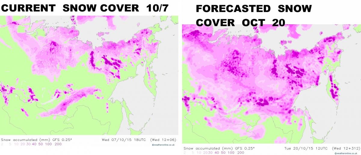
"Snow growth this year over Siberia, so far, is about average for this time of year. There are some above normal anomalies and below normal anomalies, which cancels out to about slightly above normal by an inch or two. Not anything significant like what was seen last year.
Last year, we saw the snow pack explode in early September and continue into mid October before trailing off. The theory of course is based on rapid snow growth in mid to late October which builds up cold, dense air and thus above normal heights over Siberia which eventually, by January, disrupts the Polar Vortex rotation and creates splits in the vortex, sending arctic air south in time for January, February, and March. Last year, the theory had some questionable results because some pointed out that without stratospheric warming the event never would have happened. Supporters counter that the stratospheric warming was driven in part by the Siberian effect. This debate is still being studied. However, I think they are both right in some respect. You see, the process was different last year because the snow growth started earlier and ended earlier, perhaps altering the effects of the process and thus altering the resulting influences. After all, which stormy, no one could claim the winter was as cold as the year before.
So here we are now with model guidance from the GFS, ECMWF, and various Ensemble guidance strongly pointing to a rapid growth of snow cover AND depth over northern Asia and specifically around Siberia. IF the models are right, and I can’t believe all of them would be wrong, then we have a text book set up of this theory which would strongly support a negative Arctic Oscillation driven by this process by January and continuing into March. That’s not to say the Arctic Oscillation and North Atlantic Oscillation won’t be negative in mid to late December due to other processes though.
So this is another key to keep watching over the next 2 weeks. This is exactly why I am waiting a bit before issuing my winter forecast. There is no point issuing the forecast without these key observations."
also their are other mets who agree with this. so if models are correct this is good news for us and to early for anyone to make a forecast for winter. plus could have been the reason for the AO to be not as neg as most predicted last winter.
algae888- Advanced Forecaster
- Posts : 5311
Reputation : 46
Join date : 2013-02-05
Age : 61
Location : mt. vernon, new york
Re: Long Range Thread 8.0
![]() by nutleyblizzard Thu Oct 08, 2015 10:12 am
by nutleyblizzard Thu Oct 08, 2015 10:12 am

nutleyblizzard- Senior Enthusiast
- Posts : 1952
Reputation : 41
Join date : 2014-01-30
Age : 58
Location : Nutley, new jersey
Re: Long Range Thread 8.0
![]() by amugs Thu Oct 08, 2015 10:19 am
by amugs Thu Oct 08, 2015 10:19 am
HectorO wrote:algae888 wrote:this is what he (pastelok) was trying to say...
nothing specific. very vague. this is only logical response at this early time.
These maps are so useless, especially from accuweather. Last year I think we all posted a link from like 5 years worth of these maps that were way, and I mean way off lol. Especially the one they made for the 2011/2012 one. The very snowy and cold one.
This is ABSURD and a mockery I feel of meteorological long term forecasting.
Last edited by amugs on Thu Oct 08, 2015 10:36 am; edited 1 time in total
_________________
Mugs
AKA:King: Snow Weenie
Self Proclaimed
WINTER 2014-15 : 55.12" +.02 for 6 coatings (avg. 35")
WINTER 2015-16 Total - 29.8" (Avg 35")
WINTER 2016-17 : 39.5" so far
amugs- Advanced Forecaster - Mod
- Posts : 15093
Reputation : 213
Join date : 2013-01-07
Age : 54
Location : Hillsdale,NJ
Re: Long Range Thread 8.0
![]() by amugs Thu Oct 08, 2015 10:21 am
by amugs Thu Oct 08, 2015 10:21 am
algae888 wrote:this from steve d this morning about snow growth and the AO....
"Snow growth this year over Siberia, so far, is about average for this time of year. There are some above normal anomalies and below normal anomalies, which cancels out to about slightly above normal by an inch or two. Not anything significant like what was seen last year.
Last year, we saw the snow pack explode in early September and continue into mid October before trailing off. The theory of course is based on rapid snow growth in mid to late October which builds up cold, dense air and thus above normal heights over Siberia which eventually, by January, disrupts the Polar Vortex rotation and creates splits in the vortex, sending arctic air south in time for January, February, and March. Last year, the theory had some questionable results because some pointed out that without stratospheric warming the event never would have happened. Supporters counter that the stratospheric warming was driven in part by the Siberian effect. This debate is still being studied. However, I think they are both right in some respect. You see, the process was different last year because the snow growth started earlier and ended earlier, perhaps altering the effects of the process and thus altering the resulting influences. After all, which stormy, no one could claim the winter was as cold as the year before.
So here we are now with model guidance from the GFS, ECMWF, and various Ensemble guidance strongly pointing to a rapid growth of snow cover AND depth over northern Asia and specifically around Siberia. IF the models are right, and I can’t believe all of them would be wrong, then we have a text book set up of this theory which would strongly support a negative Arctic Oscillation driven by this process by January and continuing into March. That’s not to say the Arctic Oscillation and North Atlantic Oscillation won’t be negative in mid to late December due to other processes though.
So this is another key to keep watching over the next 2 weeks. This is exactly why I am waiting a bit before issuing my winter forecast. There is no point issuing the forecast without these key observations."
also their are other mets who agree with this. so if models are correct this is good news for us and to early for anyone to make a forecast for winter. plus could have been the reason for the AO to be not as neg as most predicted last winter.
Al my paisan, I was just going to spot today how the snow growth over Siberia or Eurasia is going to "RAISE THE ROOF" over the next couple of weeks as currently projected. ALSO, LOOK AT THE EXTENT IN 5 DAYS OVER CANADA!!
To aid in visualization of this quote:
Yesterdays map

Close up of Eurasia

Look at OCT 2

Close up of Eurasia

Canada and Alaska Oct 2

Yesterday

NOW Rutgers Oct 2

Today

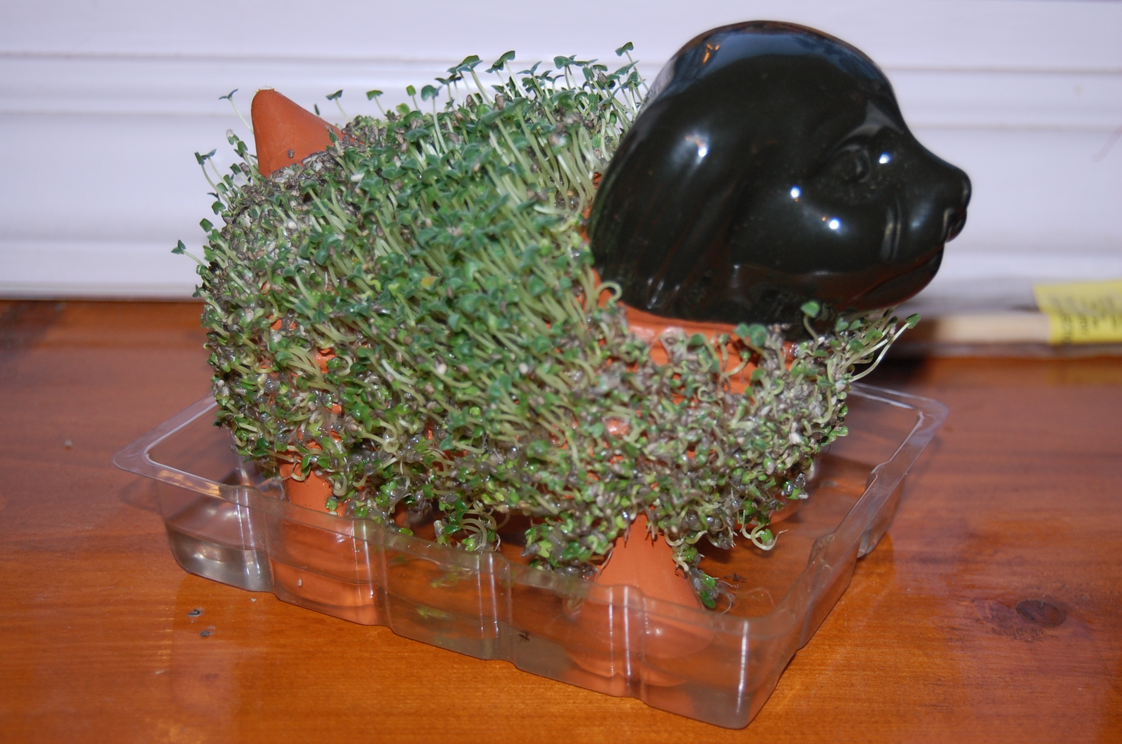
NOW for my Grand Finale - Look at my Chia Pet Grow - RUUUSSSIANNNN STYLE!! Raise the roof - WOOF WOOF!!!
Grow Rocky Grow!!!!
_________________
Mugs
AKA:King: Snow Weenie
Self Proclaimed
WINTER 2014-15 : 55.12" +.02 for 6 coatings (avg. 35")
WINTER 2015-16 Total - 29.8" (Avg 35")
WINTER 2016-17 : 39.5" so far
amugs- Advanced Forecaster - Mod
- Posts : 15093
Reputation : 213
Join date : 2013-01-07
Age : 54
Location : Hillsdale,NJ
Re: Long Range Thread 8.0
![]() by sroc4 Thu Oct 08, 2015 10:49 am
by sroc4 Thu Oct 08, 2015 10:49 am

_________________
"In weather and in life, there's no winning and losing; there's only winning and learning."
WINTER 2012/2013 TOTALS 43.65"WINTER 2017/2018 TOTALS 62.85" WINTER 2022/2023 TOTALS 4.9"
WINTER 2013/2014 TOTALS 64.85"WINTER 2018/2019 TOTALS 14.25" WINTER 2023/2024 TOTALS 13.1"
WINTER 2014/2015 TOTALS 71.20"WINTER 2019/2020 TOTALS 6.35"
WINTER 2015/2016 TOTALS 35.00"WINTER 2020/2021 TOTALS 37.75"
WINTER 2016/2017 TOTALS 42.25"WINTER 2021/2022 TOTALS 31.65"
sroc4- Admin
- Posts : 8331
Reputation : 301
Join date : 2013-01-07
Location : Wading River, LI
Re: Long Range Thread 8.0
![]() by amugs Thu Oct 08, 2015 11:05 am
by amugs Thu Oct 08, 2015 11:05 am
Scott, never understood these dots for what they mean - looks like the chicken pox to me !!sroc4 wrote:Here are the anomalies/departures from normal.
_________________
Mugs
AKA:King: Snow Weenie
Self Proclaimed
WINTER 2014-15 : 55.12" +.02 for 6 coatings (avg. 35")
WINTER 2015-16 Total - 29.8" (Avg 35")
WINTER 2016-17 : 39.5" so far
amugs- Advanced Forecaster - Mod
- Posts : 15093
Reputation : 213
Join date : 2013-01-07
Age : 54
Location : Hillsdale,NJ
Re: Long Range Thread 8.0
![]() by sroc4 Thu Oct 08, 2015 12:01 pm
by sroc4 Thu Oct 08, 2015 12:01 pm
Here is the link to that page.
http://climate.rutgers.edu/snowcover/chart_daily.php?ui_year=2015&ui_day=280&ui_set=2
sroc4 wrote:Here are the anomalies/departures from normal.

_________________
"In weather and in life, there's no winning and losing; there's only winning and learning."
WINTER 2012/2013 TOTALS 43.65"WINTER 2017/2018 TOTALS 62.85" WINTER 2022/2023 TOTALS 4.9"
WINTER 2013/2014 TOTALS 64.85"WINTER 2018/2019 TOTALS 14.25" WINTER 2023/2024 TOTALS 13.1"
WINTER 2014/2015 TOTALS 71.20"WINTER 2019/2020 TOTALS 6.35"
WINTER 2015/2016 TOTALS 35.00"WINTER 2020/2021 TOTALS 37.75"
WINTER 2016/2017 TOTALS 42.25"WINTER 2021/2022 TOTALS 31.65"
sroc4- Admin
- Posts : 8331
Reputation : 301
Join date : 2013-01-07
Location : Wading River, LI
Page 18 of 40 • 1 ... 10 ... 17, 18, 19 ... 29 ... 40 ![]()
|
|
|