
 Search
Monitoring February 15th-16th Storm
Page 1 of 9 • 1, 2, 3, 4, 5, 6, 7, 8, 9 ![]()

Monitoring February 15th-16th Storm
![]() by Frank_Wx Thu Feb 11, 2016 7:42 pm
by Frank_Wx Thu Feb 11, 2016 7:42 pm
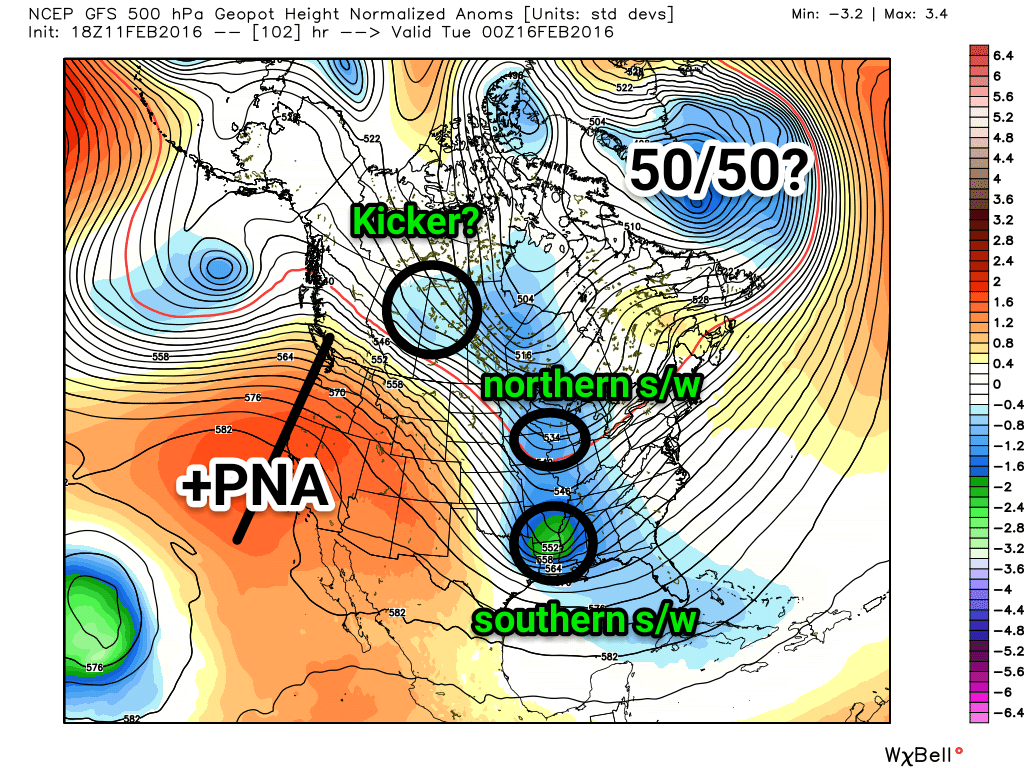
There are a few reason why models are cutting the storm to our west. The main reason is the southern energy is very amplified and there's a lot of northern stream energy phasing into the trough. This takes the trough negatively tilted very early and results in heights to rise along the east coast. Some reasons why I'm hesitant to say this will absolutely cut to our west go as follows:
1. The upper energy is not sampled very well yet. A weaker southern energy would keep heights over the east coast flatter and the phase would happen later in this case.
2. Record breaking cold temperatures this weekend will be hard to displace so quickly. Will heights respond from anomalously negative to positive that quickly? It depends on how much phasing occurs to our west.
3. The PNA is positive. A trough should naturally be located on the eastern third of the country and there definitely will be. Again, it depends on the northern and southern stream phasing and this won't get ironed out for another couple of days. The trough axis is actually not far off from being favorably positioned for our area.
4. The 50/50. If it's further south than where currently progged this will keep heights over the EC surpressed. This relates back to the anomalous cold and the timing of which it actually exits the Northeast.
5. Will there be a kicker (clipper) behind this storm that may try to push the phase to happen further east, thus preventing the trough from going negative too quickly? This is not shown very well on models right now but it's something to watch for sure.
I mentioned yesterday I'm favoring an inland or coastal hugger track with a front end thump of wintry precipitation before changing to rain. I'm still favoring this scenario, but I wouldn't be shocked to see a cold trend take place over the weekend. All I'm saying is I think the pattern isn't December-level abysmal to completely write off this next storm threat. We'll see what happens.
Last edited by Frank_Wx on Sat Feb 13, 2016 9:47 am; edited 1 time in total
_________________
_______________________________________________________________________________________________________
CLICK HERE to view NJ Strong Snowstorm Classifications

Frank_Wx- Godzilla Seeker

- Posts : 21305
Reputation : 328
Join date : 2013-01-05
Age : 31
Location : Jersey City, NJ -

Re: Monitoring February 15th-16th Storm
![]() by NjWeatherGuy Thu Feb 11, 2016 7:48 pm
by NjWeatherGuy Thu Feb 11, 2016 7:48 pm

NjWeatherGuy- Advanced Forecaster

- Posts : 4100
Reputation : 28
Join date : 2013-01-06
Location : Belle Mead, NJ
Re: Monitoring February 15th-16th Storm
![]() by Guest Thu Feb 11, 2016 7:52 pm
by Guest Thu Feb 11, 2016 7:52 pm
NE PA will be in a perfect spot!
Guest- Guest
Re: Monitoring February 15th-16th Storm
![]() by Frank_Wx Thu Feb 11, 2016 8:06 pm
by Frank_Wx Thu Feb 11, 2016 8:06 pm
syosnow94 wrote:Nice write-up Frank. A little optimism all Mugsy or Scott. Nice. How ya feelin?
NE PA will be in a perfect spot!
Awful. It'll take time.
Interior locations are in a better spot than the coast for this one, but if it cuts through Pittsburgh no one will get snow.
_________________
_______________________________________________________________________________________________________
CLICK HERE to view NJ Strong Snowstorm Classifications
Frank_Wx- Godzilla Seeker
- Posts : 21305
Reputation : 328
Join date : 2013-01-05
Age : 31
Location : Jersey City, NJ -
Re: Monitoring February 15th-16th Storm
![]() by amugs Thu Feb 11, 2016 8:26 pm
by amugs Thu Feb 11, 2016 8:26 pm
I hope you feel better soon and Tha ks for doing this even though you aren't feeling, it is greatly appreciated.
Have a hot tottee and some home made chicken soup.
_________________
Mugs
AKA:King: Snow Weenie
Self Proclaimed
WINTER 2014-15 : 55.12" +.02 for 6 coatings (avg. 35")
WINTER 2015-16 Total - 29.8" (Avg 35")
WINTER 2016-17 : 39.5" so far

amugs- Advanced Forecaster - Mod

- Posts : 15093
Reputation : 213
Join date : 2013-01-07
Age : 54
Location : Hillsdale,NJ
Re: Monitoring February 15th-16th Storm
![]() by amugs Thu Feb 11, 2016 8:30 pm
by amugs Thu Feb 11, 2016 8:30 pm
I'll take the 4 5 combo - a kicker with the 50/50 sauce in the side please. That'll be to go of course!!
_________________
Mugs
AKA:King: Snow Weenie
Self Proclaimed
WINTER 2014-15 : 55.12" +.02 for 6 coatings (avg. 35")
WINTER 2015-16 Total - 29.8" (Avg 35")
WINTER 2016-17 : 39.5" so far
amugs- Advanced Forecaster - Mod
- Posts : 15093
Reputation : 213
Join date : 2013-01-07
Age : 54
Location : Hillsdale,NJ
Re: Monitoring February 15th-16th Storm
![]() by jmanley32 Fri Feb 12, 2016 12:20 am
by jmanley32 Fri Feb 12, 2016 12:20 am


jmanley32- Senior Enthusiast

- Posts : 20517
Reputation : 108
Join date : 2013-12-12
Age : 42
Location : Yonkers, NY
Re: Monitoring February 15th-16th Storm
![]() by jmanley32 Fri Feb 12, 2016 12:23 am
by jmanley32 Fri Feb 12, 2016 12:23 am
jmanley32- Senior Enthusiast
- Posts : 20517
Reputation : 108
Join date : 2013-12-12
Age : 42
Location : Yonkers, NY
Re: Monitoring February 15th-16th Storm
![]() by NjWeatherGuy Fri Feb 12, 2016 1:19 am
by NjWeatherGuy Fri Feb 12, 2016 1:19 am
NjWeatherGuy- Advanced Forecaster
- Posts : 4100
Reputation : 28
Join date : 2013-01-06
Location : Belle Mead, NJ
Re: Monitoring February 15th-16th Storm
![]() by algae888 Fri Feb 12, 2016 1:43 am
by algae888 Fri Feb 12, 2016 1:43 am

12zcmc

00zcmc

18z gfs

00z gfs

algae888- Advanced Forecaster
- Posts : 5311
Reputation : 46
Join date : 2013-02-05
Age : 61
Location : mt. vernon, new york
Re: Monitoring February 15th-16th Storm
![]() by jmanley32 Fri Feb 12, 2016 1:53 am
by jmanley32 Fri Feb 12, 2016 1:53 am
jmanley32- Senior Enthusiast
- Posts : 20517
Reputation : 108
Join date : 2013-12-12
Age : 42
Location : Yonkers, NY
Re: Monitoring February 15th-16th Storm
![]() by jmanley32 Fri Feb 12, 2016 1:56 am
by jmanley32 Fri Feb 12, 2016 1:56 am
jmanley32- Senior Enthusiast
- Posts : 20517
Reputation : 108
Join date : 2013-12-12
Age : 42
Location : Yonkers, NY
Re: Monitoring February 15th-16th Storm
![]() by algae888 Fri Feb 12, 2016 3:56 am
by algae888 Fri Feb 12, 2016 3:56 am

nam

gfs same time frame
algae888- Advanced Forecaster
- Posts : 5311
Reputation : 46
Join date : 2013-02-05
Age : 61
Location : mt. vernon, new york
Re: Monitoring February 15th-16th Storm
![]() by algae888 Fri Feb 12, 2016 4:05 am
by algae888 Fri Feb 12, 2016 4:05 am

nam

gfs

Canadian. actually cmc and nam look close
algae888- Advanced Forecaster
- Posts : 5311
Reputation : 46
Join date : 2013-02-05
Age : 61
Location : mt. vernon, new york
Re: Monitoring February 15th-16th Storm
![]() by algae888 Fri Feb 12, 2016 4:10 am
by algae888 Fri Feb 12, 2016 4:10 am
algae888- Advanced Forecaster
- Posts : 5311
Reputation : 46
Join date : 2013-02-05
Age : 61
Location : mt. vernon, new york
Re: Monitoring February 15th-16th Storm
![]() by algae888 Fri Feb 12, 2016 4:13 am
by algae888 Fri Feb 12, 2016 4:13 am


pretty big spread. look at how fast several of the members are. takes low east of li by 6z tues.
algae888- Advanced Forecaster
- Posts : 5311
Reputation : 46
Join date : 2013-02-05
Age : 61
Location : mt. vernon, new york
Re: Monitoring February 15th-16th Storm
![]() by algae888 Fri Feb 12, 2016 4:20 am
by algae888 Fri Feb 12, 2016 4:20 am

algae888- Advanced Forecaster
- Posts : 5311
Reputation : 46
Join date : 2013-02-05
Age : 61
Location : mt. vernon, new york
Re: Monitoring February 15th-16th Storm
![]() by NjWeatherGuy Fri Feb 12, 2016 9:49 am
by NjWeatherGuy Fri Feb 12, 2016 9:49 am
http://forums.accuweather.com/index.php?act=attach&type=post&id=282881
NjWeatherGuy- Advanced Forecaster
- Posts : 4100
Reputation : 28
Join date : 2013-01-06
Location : Belle Mead, NJ
Re: Monitoring February 15th-16th Storm
![]() by NjWeatherGuy Fri Feb 12, 2016 9:52 am
by NjWeatherGuy Fri Feb 12, 2016 9:52 am
Last edited by NjWeatherGuy on Fri Feb 12, 2016 9:56 am; edited 1 time in total
NjWeatherGuy- Advanced Forecaster
- Posts : 4100
Reputation : 28
Join date : 2013-01-06
Location : Belle Mead, NJ
Re: Monitoring February 15th-16th Storm
![]() by algae888 Fri Feb 12, 2016 9:55 am
by algae888 Fri Feb 12, 2016 9:55 am
algae888- Advanced Forecaster
- Posts : 5311
Reputation : 46
Join date : 2013-02-05
Age : 61
Location : mt. vernon, new york


algae888- Advanced Forecaster
- Posts : 5311
Reputation : 46
Join date : 2013-02-05
Age : 61
Location : mt. vernon, new york
Re: Monitoring February 15th-16th Storm
![]() by NjWeatherGuy Fri Feb 12, 2016 10:03 am
by NjWeatherGuy Fri Feb 12, 2016 10:03 am
https://www.njstrongweatherforum.com/t224p25-february-12th-14th-storm-potential
Look over the inital Feb 12-14, 2014 thread, look familiar? High over atlantic (none to N or NW), kicker, overall negative outlook (at least by me initally), similar setup, may be straw grasping here but could that be a similar analog?
NjWeatherGuy- Advanced Forecaster
- Posts : 4100
Reputation : 28
Join date : 2013-01-06
Location : Belle Mead, NJ
Re: Monitoring February 15th-16th Storm
![]() by NjWeatherGuy Fri Feb 12, 2016 10:12 am
by NjWeatherGuy Fri Feb 12, 2016 10:12 am
NjWeatherGuy- Advanced Forecaster
- Posts : 4100
Reputation : 28
Join date : 2013-01-06
Location : Belle Mead, NJ
Re: Monitoring February 15th-16th Storm
![]() by sroc4 Fri Feb 12, 2016 11:00 am
by sroc4 Fri Feb 12, 2016 11:00 am
NjWeatherGuy wrote:Hmmmm
https://www.njstrongweatherforum.com/t224p25-february-12th-14th-storm-potential
Look over the inital Feb 12-14, 2014 thread, look familiar? High over atlantic (none to N or NW), kicker, overall negative outlook (at least by me initally), similar setup, may be straw grasping here but could that be a similar analog?
Tom I dont think your grasping at straws at all. Im not sure just how far we can trend with this set up, but I do believe that we can def trend colder for longer. For me this is not a question of will be stay all frozen, because I believe we def change over, al least the coastal plain, but In my experience with overruning events the cold ends up being much harder to scour out then what models show in the md range. This was a text message I sent a friend of mine after he asked me what I thought about the set up:
"Youve got three things causing it (It referring to why/how such anomalously cold air can simply just disappear so quickly). As per the teleconnections the PNA goes neg and the EPO spikes positive collapsing ridge out west, and the NAO which is now neutral to slt neg spikes positive as well. The combo means a progressive flow which lifts the cold right up and out of here. That being said cold air this time of year is def hard to scour out. Front end thump is what Im thinking with trends towards a later and later changeover."
Now I have yet to look in any great detail at the models for two reasons. 1) Like Frank mentioned the energy involved has been in very poorly sampled areas, so I still expect things to flip flop and change for better or worse until Sat 12z or so. 2) Because of the stupid IVT set up earlier in the week I have been way behind on my business duties so Ive had to play catch up.
Anyway I will have more to add as we head into the weekend.
_________________
"In weather and in life, there's no winning and losing; there's only winning and learning."
WINTER 2012/2013 TOTALS 43.65"WINTER 2017/2018 TOTALS 62.85" WINTER 2022/2023 TOTALS 4.9"
WINTER 2013/2014 TOTALS 64.85"WINTER 2018/2019 TOTALS 14.25" WINTER 2023/2024 TOTALS 13.1"
WINTER 2014/2015 TOTALS 71.20"WINTER 2019/2020 TOTALS 6.35"
WINTER 2015/2016 TOTALS 35.00"WINTER 2020/2021 TOTALS 37.75"
WINTER 2016/2017 TOTALS 42.25"WINTER 2021/2022 TOTALS 31.65"

sroc4- Admin
- Posts : 8331
Reputation : 301
Join date : 2013-01-07
Location : Wading River, LI
Re: Monitoring February 15th-16th Storm
![]() by NjWeatherGuy Fri Feb 12, 2016 11:02 am
by NjWeatherGuy Fri Feb 12, 2016 11:02 am
http://forums.accuweather.com/index.php?act=attach&type=post&id=282976
NjWeatherGuy- Advanced Forecaster
- Posts : 4100
Reputation : 28
Join date : 2013-01-06
Location : Belle Mead, NJ
Page 1 of 9 • 1, 2, 3, 4, 5, 6, 7, 8, 9 ![]()
|
|
|