
 Search
Monitoring February 15th-16th Storm
Page 2 of 9 •  1, 2, 3, 4, 5, 6, 7, 8, 9
 ![]()
Re: Monitoring February 15th-16th Storm
![]() by sroc4 Fri Feb 12, 2016 11:00 am
by sroc4 Fri Feb 12, 2016 11:00 am
NjWeatherGuy wrote:Hmmmm
https://www.njstrongweatherforum.com/t224p25-february-12th-14th-storm-potential
Look over the inital Feb 12-14, 2014 thread, look familiar? High over atlantic (none to N or NW), kicker, overall negative outlook (at least by me initally), similar setup, may be straw grasping here but could that be a similar analog?
Tom I dont think your grasping at straws at all. Im not sure just how far we can trend with this set up, but I do believe that we can def trend colder for longer. For me this is not a question of will be stay all frozen, because I believe we def change over, al least the coastal plain, but In my experience with overruning events the cold ends up being much harder to scour out then what models show in the md range. This was a text message I sent a friend of mine after he asked me what I thought about the set up:
"Youve got three things causing it (It referring to why/how such anomalously cold air can simply just disappear so quickly). As per the teleconnections the PNA goes neg and the EPO spikes positive collapsing ridge out west, and the NAO which is now neutral to slt neg spikes positive as well. The combo means a progressive flow which lifts the cold right up and out of here. That being said cold air this time of year is def hard to scour out. Front end thump is what Im thinking with trends towards a later and later changeover."
Now I have yet to look in any great detail at the models for two reasons. 1) Like Frank mentioned the energy involved has been in very poorly sampled areas, so I still expect things to flip flop and change for better or worse until Sat 12z or so. 2) Because of the stupid IVT set up earlier in the week I have been way behind on my business duties so Ive had to play catch up.
Anyway I will have more to add as we head into the weekend.
sroc4- Admin

- Posts : 8331
Join date : 2013-01-07
Re: Monitoring February 15th-16th Storm
![]() by NjWeatherGuy Fri Feb 12, 2016 11:02 am
by NjWeatherGuy Fri Feb 12, 2016 11:02 am
http://forums.accuweather.com/index.php?act=attach&type=post&id=282976
NjWeatherGuy- Advanced Forecaster

- Posts : 4100
Join date : 2013-01-06
Re: Monitoring February 15th-16th Storm
![]() by NjWeatherGuy Fri Feb 12, 2016 11:04 am
by NjWeatherGuy Fri Feb 12, 2016 11:04 am
Feb 14 changed over here for a while, long lull and light rain but front end thump was about 15", another 3 or so on the back end after the heavy rain and t storms with that one. These storms can be very dynamic which is why im somewhat excited.sroc4 wrote:NjWeatherGuy wrote:Hmmmm
https://www.njstrongweatherforum.com/t224p25-february-12th-14th-storm-potential
Look over the inital Feb 12-14, 2014 thread, look familiar? High over atlantic (none to N or NW), kicker, overall negative outlook (at least by me initally), similar setup, may be straw grasping here but could that be a similar analog?
Tom I dont think your grasping at straws at all. Im not sure just how far we can trend with this set up, but I do believe that we can def trend colder for longer. For me this is not a question of will be stay all frozen, because I believe we def change over, al least the coastal plain, but In my experience with overruning events the cold ends up being much harder to scour out then what models show in the md range. This was a text message I sent a friend of mine after he asked me what I thought about the set up:
"Youve got three things causing it (It referring to why/how such anomalously cold air can simply just disappear so quickly). As per the teleconnections the PNA goes neg and the EPO spikes positive collapsing ridge out west, and the NAO which is now neutral to slt neg spikes positive as well. The combo means a progressive flow which lifts the cold right up and out of here. That being said cold air this time of year is def hard to scour out. Front end thump is what Im thinking with trends towards a later and later changeover."
Now I have yet to look in any great detail at the models for two reasons. 1) Like Frank mentioned the energy involved has been in very poorly sampled areas, so I still expect things to flip flop and change for better or worse until Sat 12z or so. 2) Because of the stupid IVT set up earlier in the week I have been way behind on my business duties so Ive had to play catch up.
Anyway I will have more to add as we head into the weekend.

NjWeatherGuy- Advanced Forecaster
- Posts : 4100
Reputation : 28
Join date : 2013-01-06
Location : Belle Mead, NJ
Re: Monitoring February 15th-16th Storm
![]() by hyde345 Fri Feb 12, 2016 11:26 am
by hyde345 Fri Feb 12, 2016 11:26 am

hyde345- Pro Enthusiast

- Posts : 1082
Reputation : 48
Join date : 2013-01-08
Location : Hyde Park, NY
Re: Monitoring February 15th-16th Storm
![]() by algae888 Fri Feb 12, 2016 11:52 am
by algae888 Fri Feb 12, 2016 11:52 am

algae888- Advanced Forecaster
- Posts : 5311
Reputation : 46
Join date : 2013-02-05
Age : 61
Location : mt. vernon, new york
Re: Monitoring February 15th-16th Storm
![]() by algae888 Fri Feb 12, 2016 11:53 am
by algae888 Fri Feb 12, 2016 11:53 am
algae888- Advanced Forecaster
- Posts : 5311
Reputation : 46
Join date : 2013-02-05
Age : 61
Location : mt. vernon, new york
Re: Monitoring February 15th-16th Storm
![]() by algae888 Fri Feb 12, 2016 11:56 am
by algae888 Fri Feb 12, 2016 11:56 am
algae888- Advanced Forecaster
- Posts : 5311
Reputation : 46
Join date : 2013-02-05
Age : 61
Location : mt. vernon, new york
Re: Monitoring February 15th-16th Storm
![]() by docstox12 Fri Feb 12, 2016 12:01 pm
by docstox12 Fri Feb 12, 2016 12:01 pm
hyde345 wrote:Better run on the 12z GFS shifting east. Still looks like snow to rain in most areas but the further east the longer the front end snows and the possibility of changeover back to snow especially in HV and EPA. Another 50-75 miles east and this could get real interesting.
If it doesn't go TOO FAR EAST as usual, then we will have a shot at finally beating out the S and E folks.

docstox12- Wx Statistician Guru

- Posts : 8507
Reputation : 222
Join date : 2013-01-07
Age : 73
Location : Monroe NY
Re: Monitoring February 15th-16th Storm
![]() by algae888 Fri Feb 12, 2016 12:05 pm
by algae888 Fri Feb 12, 2016 12:05 pm
algae888- Advanced Forecaster
- Posts : 5311
Reputation : 46
Join date : 2013-02-05
Age : 61
Location : mt. vernon, new york
Re: Monitoring February 15th-16th Storm
![]() by docstox12 Fri Feb 12, 2016 12:06 pm
by docstox12 Fri Feb 12, 2016 12:06 pm
docstox12- Wx Statistician Guru
- Posts : 8507
Reputation : 222
Join date : 2013-01-07
Age : 73
Location : Monroe NY
Re: Monitoring February 15th-16th Storm
![]() by sroc4 Fri Feb 12, 2016 12:07 pm
by sroc4 Fri Feb 12, 2016 12:07 pm
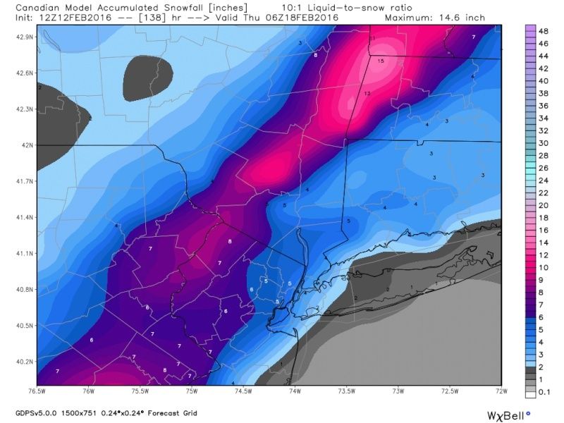
algae888 wrote:Doc cp and all our nw family this may be your storm GFS has front and back and snow with rain in between about 7 inches for you guys between both of front and back end about an inch for the immediate coast and you can figure out the rest in between. Waiting on the CMC snow maps but they are going to be lovely for you guys even parts of Rockland County never change to plain rain
_________________
"In weather and in life, there's no winning and losing; there's only winning and learning."
WINTER 2012/2013 TOTALS 43.65"WINTER 2017/2018 TOTALS 62.85" WINTER 2022/2023 TOTALS 4.9"
WINTER 2013/2014 TOTALS 64.85"WINTER 2018/2019 TOTALS 14.25" WINTER 2023/2024 TOTALS 13.1"
WINTER 2014/2015 TOTALS 71.20"WINTER 2019/2020 TOTALS 6.35"
WINTER 2015/2016 TOTALS 35.00"WINTER 2020/2021 TOTALS 37.75"
WINTER 2016/2017 TOTALS 42.25"WINTER 2021/2022 TOTALS 31.65"

sroc4- Admin
- Posts : 8331
Reputation : 301
Join date : 2013-01-07
Location : Wading River, LI
Re: Monitoring February 15th-16th Storm
![]() by algae888 Fri Feb 12, 2016 12:09 pm
by algae888 Fri Feb 12, 2016 12:09 pm
algae888- Advanced Forecaster
- Posts : 5311
Reputation : 46
Join date : 2013-02-05
Age : 61
Location : mt. vernon, new york
Re: Monitoring February 15th-16th Storm
![]() by CPcantmeasuresnow Fri Feb 12, 2016 12:26 pm
by CPcantmeasuresnow Fri Feb 12, 2016 12:26 pm

CPcantmeasuresnow- Wx Statistician Guru
- Posts : 7274
Reputation : 230
Join date : 2013-01-07
Age : 103
Location : Eastern Orange County, NY
Re: Monitoring February 15th-16th Storm
![]() by skinsfan1177 Fri Feb 12, 2016 12:39 pm
by skinsfan1177 Fri Feb 12, 2016 12:39 pm
Doc this isn't my storm here all rain most likely my way you guys I'm pulling for.docstox12 wrote:hyde345 wrote:Better run on the 12z GFS shifting east. Still looks like snow to rain in most areas but the further east the longer the front end snows and the possibility of changeover back to snow especially in HV and EPA. Another 50-75 miles east and this could get real interesting.
If it doesn't go TOO FAR EAST as usual, then we will have a shot at finally beating out the S and E folks.

skinsfan1177- Senior Enthusiast

- Posts : 4485
Reputation : 35
Join date : 2013-01-07
Age : 46
Location : Point Pleasant Boro
Re: Monitoring February 15th-16th Storm
![]() by Frank_Wx Fri Feb 12, 2016 1:12 pm
by Frank_Wx Fri Feb 12, 2016 1:12 pm
12z GFS


and then the rain / wind .... wow


Models are showing a storm track close to what I was expecting. Either inland or right up the coast. I wonder if it tries to trend east still. That is what I was trying to get to in my post yesterday. If it does, we'll gradually see more wintry solutions opposed to warm ones.
_________________
_______________________________________________________________________________________________________
CLICK HERE to view NJ Strong Snowstorm Classifications

Frank_Wx- Godzilla Seeker
- Posts : 21305
Reputation : 328
Join date : 2013-01-05
Age : 31
Location : Jersey City, NJ -

Re: Monitoring February 15th-16th Storm
![]() by Frank_Wx Fri Feb 12, 2016 1:13 pm
by Frank_Wx Fri Feb 12, 2016 1:13 pm

The model is not fully out yet but you can see how it warms up and all the rain getting ready to move in

_________________
_______________________________________________________________________________________________________
CLICK HERE to view NJ Strong Snowstorm Classifications
Frank_Wx- Godzilla Seeker
- Posts : 21305
Reputation : 328
Join date : 2013-01-05
Age : 31
Location : Jersey City, NJ -
Re: Monitoring February 15th-16th Storm
![]() by Guest Fri Feb 12, 2016 1:15 pm
by Guest Fri Feb 12, 2016 1:15 pm
Guest- Guest
Re: Monitoring February 15th-16th Storm
![]() by Frank_Wx Fri Feb 12, 2016 1:15 pm
by Frank_Wx Fri Feb 12, 2016 1:15 pm

_________________
_______________________________________________________________________________________________________
CLICK HERE to view NJ Strong Snowstorm Classifications
Frank_Wx- Godzilla Seeker
- Posts : 21305
Reputation : 328
Join date : 2013-01-05
Age : 31
Location : Jersey City, NJ -
Re: Monitoring February 15th-16th Storm
![]() by jimv45 Fri Feb 12, 2016 1:19 pm
by jimv45 Fri Feb 12, 2016 1:19 pm
jimv45- Senior Enthusiast
- Posts : 1168
Reputation : 36
Join date : 2013-09-20
Location : Hopewell jct.
Re: Monitoring February 15th-16th Storm
![]() by Guest Fri Feb 12, 2016 1:21 pm
by Guest Fri Feb 12, 2016 1:21 pm
Guest- Guest
Re: Monitoring February 15th-16th Storm
![]() by jimv45 Fri Feb 12, 2016 1:25 pm
by jimv45 Fri Feb 12, 2016 1:25 pm
jimv45- Senior Enthusiast
- Posts : 1168
Reputation : 36
Join date : 2013-09-20
Location : Hopewell jct.
Re: Monitoring February 15th-16th Storm
![]() by docstox12 Fri Feb 12, 2016 2:30 pm
by docstox12 Fri Feb 12, 2016 2:30 pm
skinsfan1177 wrote:Doc this isn't my storm here all rain most likely my way you guys I'm pulling for.docstox12 wrote:hyde345 wrote:Better run on the 12z GFS shifting east. Still looks like snow to rain in most areas but the further east the longer the front end snows and the possibility of changeover back to snow especially in HV and EPA. Another 50-75 miles east and this could get real interesting.
If it doesn't go TOO FAR EAST as usual, then we will have a shot at finally beating out the S and E folks.
Thanks for that skins, but I'm reading Frank's latest analysis that this is pretty far west and everyone gets rain.Oh,well...
docstox12- Wx Statistician Guru
- Posts : 8507
Reputation : 222
Join date : 2013-01-07
Age : 73
Location : Monroe NY
Re: Monitoring February 15th-16th Storm
![]() by docstox12 Fri Feb 12, 2016 2:31 pm
by docstox12 Fri Feb 12, 2016 2:31 pm
syosnow94 wrote:Hey Doc, Cp, anyone else up north. You say you will beat me on this storm, but I have a technicality to raise with you. If I'm not at home, but rather in NE Pa, isn't that my backyard for this storm? I'm pretty sure the only reason you guys N and W will jackpot potentially, is because I will be N and W for this storm, so does the total really count?
Moot point, Jimmy, Frank's analysis of the latest models shows it way west and all rain here.
Recap at 2:48 PM...I should not have said all rain, Frank did mention a front end thump of snow/slop, then heavy rain.Sorry bout dat!
Last edited by docstox12 on Fri Feb 12, 2016 2:49 pm; edited 1 time in total
docstox12- Wx Statistician Guru
- Posts : 8507
Reputation : 222
Join date : 2013-01-07
Age : 73
Location : Monroe NY
Re: Monitoring February 15th-16th Storm
![]() by Guest Fri Feb 12, 2016 2:35 pm
by Guest Fri Feb 12, 2016 2:35 pm
Guest- Guest
Re: Monitoring February 15th-16th Storm
![]() by jimv45 Fri Feb 12, 2016 2:36 pm
by jimv45 Fri Feb 12, 2016 2:36 pm
jimv45- Senior Enthusiast
- Posts : 1168
Reputation : 36
Join date : 2013-09-20
Location : Hopewell jct.
Re: Monitoring February 15th-16th Storm
![]() by docstox12 Fri Feb 12, 2016 2:51 pm
by docstox12 Fri Feb 12, 2016 2:51 pm
jimv45 wrote:yea doc it west and the heavy stuff seems to be to if EURO is right.
If that Euro verifies, I'm going to feel like a .300 major league hitter in an 0 for 20 slump,LOL! "Storms to the East of me, storms to the south of me, storms to the west of me...." Geez, even a blind squirrel finds a nut once in a while!!!
docstox12- Wx Statistician Guru
- Posts : 8507
Reputation : 222
Join date : 2013-01-07
Age : 73
Location : Monroe NY
Re: Monitoring February 15th-16th Storm
![]() by jimv45 Fri Feb 12, 2016 2:55 pm
by jimv45 Fri Feb 12, 2016 2:55 pm
jimv45- Senior Enthusiast
- Posts : 1168
Reputation : 36
Join date : 2013-09-20
Location : Hopewell jct.
Page 2 of 9 • 1, 2, 3, 4, 5, 6, 7, 8, 9 ![]()
|
|
|