
 Search
2016 Tropical Cyclone Discussions
Page 8 of 33 •  1 ... 5 ... 7, 8, 9 ... 20 ... 33
 ![]()
Re: 2016 Tropical Cyclone Discussions
![]() by jmanley32 Tue Aug 23, 2016 9:40 am
by jmanley32 Tue Aug 23, 2016 9:40 am
jmanley32- Senior Enthusiast

- Posts : 20516
Join date : 2013-12-12
Re: 2016 Tropical Cyclone Discussions
![]() by NjWeatherGuy Tue Aug 23, 2016 10:07 am
by NjWeatherGuy Tue Aug 23, 2016 10:07 am
NjWeatherGuy- Advanced Forecaster

- Posts : 4100
Join date : 2013-01-06
Re: 2016 Tropical Cyclone Discussions
![]() by NjWeatherGuy Tue Aug 23, 2016 10:19 am
by NjWeatherGuy Tue Aug 23, 2016 10:19 am

NjWeatherGuy- Advanced Forecaster
- Posts : 4100
Reputation : 28
Join date : 2013-01-06
Location : Belle Mead, NJ
Re: 2016 Tropical Cyclone Discussions
![]() by NjWeatherGuy Tue Aug 23, 2016 10:58 am
by NjWeatherGuy Tue Aug 23, 2016 10:58 am
http://meteocentre.com/models/explorateur.php?lang=en&map=na&run=00&mod=ecmwf&stn=PNM&comp=1&run2=00&mod2=ecmwf&stn2=PNM&hh2=216&fixhh=1&stn2_type=prog&mode=latest&yyyy=latest&mm=latest&dd=latest&hh=240
NjWeatherGuy- Advanced Forecaster
- Posts : 4100
Reputation : 28
Join date : 2013-01-06
Location : Belle Mead, NJ
Re: 2016 Tropical Cyclone Discussions
![]() by sroc4 Tue Aug 23, 2016 11:31 am
by sroc4 Tue Aug 23, 2016 11:31 am
Frank_Wx wrote:Hmmm
Where does it go from there OTS? Is there any possibility from there if that were the track we would have to be on the look out? What causes the double hit for FL, never seen that crossing FL then quick right back over and up coast, or not remembering anyways. I find it amaqzing that its stronger as it heads up this way on the Euro than it was down by FL, that's concerning and shows just how hot spot the waters are up and down the EC. I know the HWRF isn't most of your favorites but I saw a chart of last years track record and it wasn't that bad, so saying that HWRF has a cat 4 in 120 hrs just east of northern Bahamas....And yes that's lil ol' Fiona to the north haha
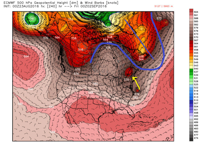
Hey JMAN. Lets look at the 00zeuro verbatim to answer your questions. To answer your your third question first: What causes the double hit for FL.
As 99L, or possibly TD by then, makes it into the Bahamas you can see there is a text book ridge over top of the tropical low. All the while the trop low is sitting over boiling waters.
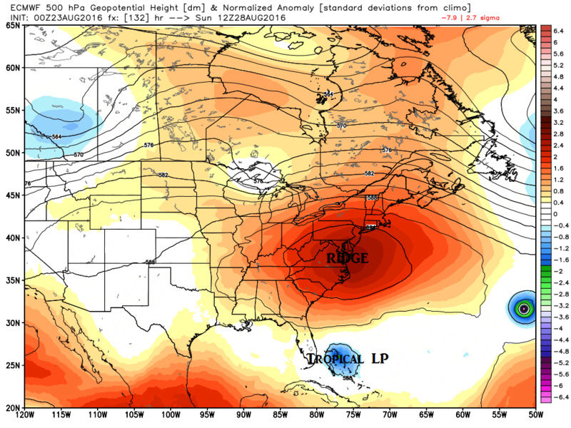
Honestly with this set up the only reasons it wouldn't strengthen from here is:
a) the wave gets destroyed by the Caribbean Islands before it ever gets there
b) there is simply too much wind shear
c) there is too much dry air mixing in or
d) any or all of the above
All of these things are still plausible moving forward
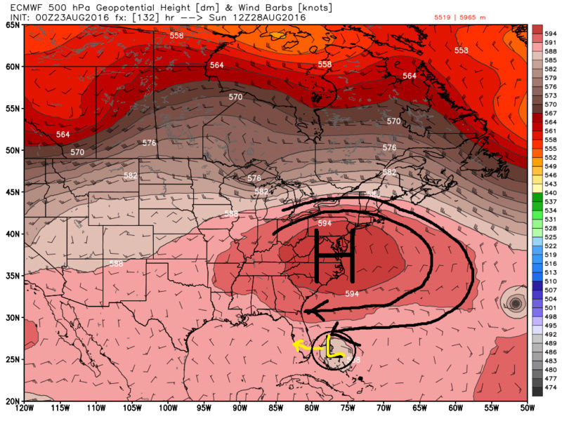
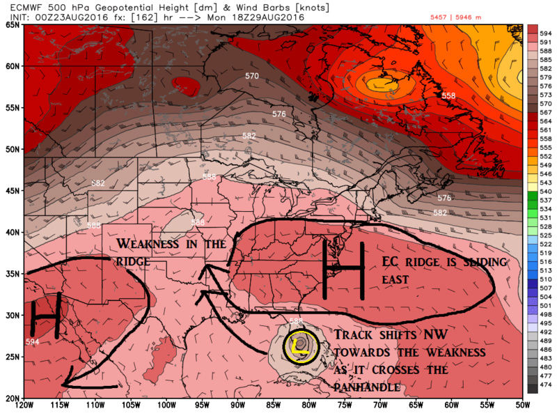
You can clearly see by the images above the steering takes it almost due west over the Fla Peninsula. But look what starts happening as we head towards hr 162. The ridge begins to weaken and slide east off the coast which creates a weakness in the ridge. The system now shifts its track NW as it enters into the GOM towards the weakness.
By hr 198 the ridge along the EC has now broken down and is building in again SE of the system all the while the system is now being tugged north by the affects of the westerlies sceeming across the Northern Conus and pushed north by the steering flow of the ridge.
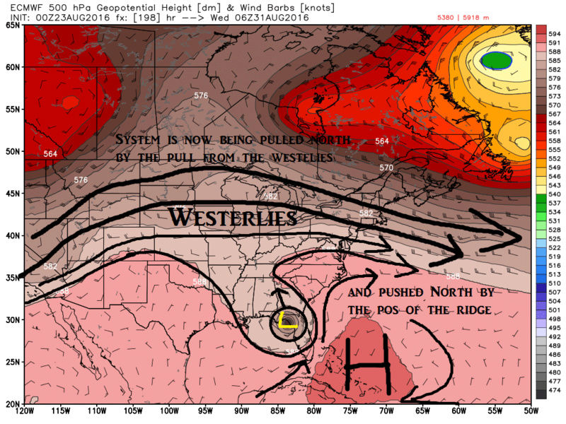
By the end of the run hr 240 you can see it just of the NC coast. To now answer your first question...Extrapolated based on the current look at 500mb verbatim on this run I would think the track conts NE and OTS, but a close call for Cape Cod. However the entire area circled in blue would be key going forward with the track.
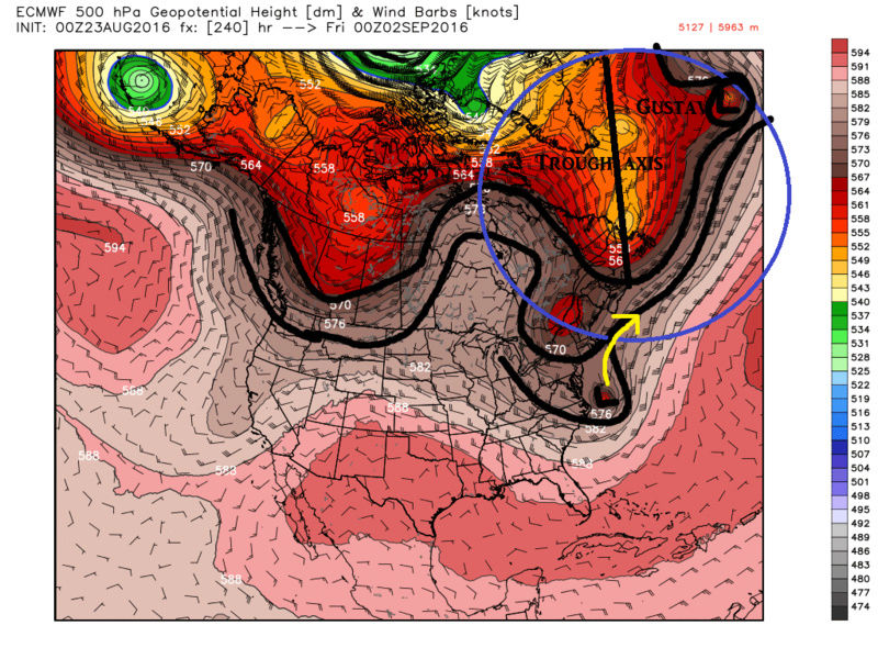
Answering your second question yes I absolutely think that if the Euro soln were to play out verbatim through say hr 200-228 there could be a scenario where it turns back to the N or even NW back into the EC instead of OTS. Let me be very clear; however, this is simply for arguments sake based on the 00z Euro run verbatim and there are still way to many variables in the next 1-3, and 3-5 days to truly speculate. But if the trough axis in the North Atlantic was tilted more negative and the trough were to be a little deeper S & E then it could act as a block and steer it back towards the coast. With the NAO being sustained neg for some time now, and with Gustav, a potentially strong hurricane, recurving the 500mb blocking pattern in the N Atlantic could be more apmplified than is being portrayed here leading towards a track back towards the coast. Of course the opposite scenario is just as likely at this stage.
Hope that helps
_________________
"In weather and in life, there's no winning and losing; there's only winning and learning."
WINTER 2012/2013 TOTALS 43.65"WINTER 2017/2018 TOTALS 62.85" WINTER 2022/2023 TOTALS 4.9"
WINTER 2013/2014 TOTALS 64.85"WINTER 2018/2019 TOTALS 14.25" WINTER 2023/2024 TOTALS 13.1"
WINTER 2014/2015 TOTALS 71.20"WINTER 2019/2020 TOTALS 6.35"
WINTER 2015/2016 TOTALS 35.00"WINTER 2020/2021 TOTALS 37.75"
WINTER 2016/2017 TOTALS 42.25"WINTER 2021/2022 TOTALS 31.65"

sroc4- Admin

- Posts : 8331
Reputation : 301
Join date : 2013-01-07
Location : Wading River, LI
Re: 2016 Tropical Cyclone Discussions
![]() by amugs Tue Aug 23, 2016 11:50 am
by amugs Tue Aug 23, 2016 11:50 am
http://www.tropicaltidbits.com/recon/
_________________
Mugs
AKA:King: Snow Weenie
Self Proclaimed
WINTER 2014-15 : 55.12" +.02 for 6 coatings (avg. 35")
WINTER 2015-16 Total - 29.8" (Avg 35")
WINTER 2016-17 : 39.5" so far

amugs- Advanced Forecaster - Mod

- Posts : 15093
Reputation : 213
Join date : 2013-01-07
Age : 54
Location : Hillsdale,NJ
Re: 2016 Tropical Cyclone Discussions
![]() by jmanley32 Tue Aug 23, 2016 12:08 pm
by jmanley32 Tue Aug 23, 2016 12:08 pm
sroc4 wrote:jmanley32 wrote:sroc4 wrote:Frank_Wx wrote:Hmmm
Where does it go from there OTS? Is there any possibility from there if that were the track we would have to be on the look out? What causes the double hit for FL, never seen that crossing FL then quick right back over and up coast, or not remembering anyways. I find it amaqzing that its stronger as it heads up this way on the Euro than it was down by FL, that's concerning and shows just how hot spot the waters are up and down the EC. I know the HWRF isn't most of your favorites but I saw a chart of last years track record and it wasn't that bad, so saying that HWRF has a cat 4 in 120 hrs just east of northern Bahamas....And yes that's lil ol' Fiona to the north haha
Hey JMAN. Lets look at the 00zeuro verbatim to answer your questions. To answer your your third question first: What causes the double hit for FL.
As 99L, or possibly TD by then, makes it into the Bahamas you can see there is a text book ridge over top of the tropical low. All the while the trop low is sitting over boiling waters.
Honestly with this set up the only reasons it wouldn't strengthen from here is:
a) the wave gets destroyed by the Caribbean Islands before it ever gets there
b) there is simply too much wind shear
c) there is too much dry air mixing in or
d) any or all of the above
All of these things are still plausible moving forward
You can clearly see by the images above the steering takes it almost due west over the Fla Peninsula. But look what starts happening as we head towards hr 162. The ridge begins to weaken and slide east off the coast which creates a weakness in the ridge. The system now shifts its track NW as it enters into the GOM towards the weakness.
By hr 198 the ridge along the EC has now broken down and is building in again SE of the system all the while the system is now being tugged north by the affects of the westerlies sceeming across the Northern Conus and pushed north by the steering flow of the ridge.
By the end of the run hr 240 you can see it just of the NC coast. To now answer your first question...Extrapolated based on the current look at 500mb verbatim on this run I would think the track conts NE and OTS, but a close call for Cape Cod. However the entire area circled in blue would be key going forward with the track.
Answering your second question yes I absolutely think that if the Euro soln were to play out verbatim through say hr 200-228 there could be a scenario where it turns back to the N or even NW back into the EC instead of OTS. Let me be very clear; however, this is simply for arguments sake based on the 00z Euro run verbatim and there are still way to many variables in the next 1-3, and 3-5 days to truly speculate. But if the trough axis in the North Atlantic was tilted more negative and the trough were to be a little deeper S & E then it could act as a block and steer it back towards the coast. With the NAO being sustained neg for some time now, and with Gustav, a potentially strong hurricane, recurving the 500mb blocking pattern in the N Atlantic could be more apmplified than is being portrayed here leading towards a track back towards the coast. Of course the opposite scenario is just as likely at this stage.
Hope that helps
Yes cool thanks! So its really a wait and see as we basically already knew. Hoping HH can figure out somethings cuz GFS is just so odd as all other models show development some to the extreme, I dunno whats wrong with the GFS.

jmanley32- Senior Enthusiast
- Posts : 20516
Reputation : 108
Join date : 2013-12-12
Age : 42
Location : Yonkers, NY
Re: 2016 Tropical Cyclone Discussions
![]() by amugs Tue Aug 23, 2016 12:52 pm
by amugs Tue Aug 23, 2016 12:52 pm

_________________
Mugs
AKA:King: Snow Weenie
Self Proclaimed
WINTER 2014-15 : 55.12" +.02 for 6 coatings (avg. 35")
WINTER 2015-16 Total - 29.8" (Avg 35")
WINTER 2016-17 : 39.5" so far
amugs- Advanced Forecaster - Mod
- Posts : 15093
Reputation : 213
Join date : 2013-01-07
Age : 54
Location : Hillsdale,NJ

nutleyblizzard- Senior Enthusiast
- Posts : 1952
Reputation : 41
Join date : 2014-01-30
Age : 58
Location : Nutley, new jersey
Re: 2016 Tropical Cyclone Discussions
![]() by jmanley32 Tue Aug 23, 2016 2:49 pm
by jmanley32 Tue Aug 23, 2016 2:49 pm
jmanley32- Senior Enthusiast
- Posts : 20516
Reputation : 108
Join date : 2013-12-12
Age : 42
Location : Yonkers, NY
Re: 2016 Tropical Cyclone Discussions
![]() by jmanley32 Tue Aug 23, 2016 2:50 pm
by jmanley32 Tue Aug 23, 2016 2:50 pm
jmanley32- Senior Enthusiast
- Posts : 20516
Reputation : 108
Join date : 2013-12-12
Age : 42
Location : Yonkers, NY
Re: 2016 Tropical Cyclone Discussions
![]() by Math23x7 Tue Aug 23, 2016 2:50 pm
by Math23x7 Tue Aug 23, 2016 2:50 pm
nutleyblizzard wrote:
GOOD LORD
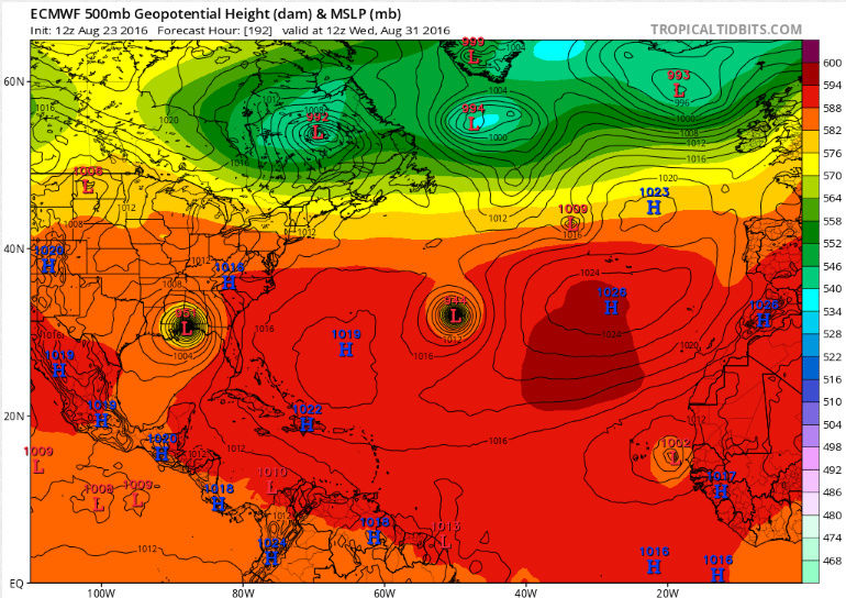
Yup, here's a bigger picture of the Atlantic Basin hr 192 on the 12Z EURO. You can also see Gaston in the central Atlantic and a new wave off the African coast.
Math23x7- Wx Statistician Guru

- Posts : 2379
Reputation : 68
Join date : 2013-01-08
Re: 2016 Tropical Cyclone Discussions
![]() by nutleyblizzard Tue Aug 23, 2016 2:52 pm
by nutleyblizzard Tue Aug 23, 2016 2:52 pm

nutleyblizzard- Senior Enthusiast
- Posts : 1952
Reputation : 41
Join date : 2014-01-30
Age : 58
Location : Nutley, new jersey
Re: 2016 Tropical Cyclone Discussions
![]() by sroc4 Tue Aug 23, 2016 2:53 pm
by sroc4 Tue Aug 23, 2016 2:53 pm
Last edited by sroc4 on Tue Aug 23, 2016 2:56 pm; edited 1 time in total
_________________
"In weather and in life, there's no winning and losing; there's only winning and learning."
WINTER 2012/2013 TOTALS 43.65"WINTER 2017/2018 TOTALS 62.85" WINTER 2022/2023 TOTALS 4.9"
WINTER 2013/2014 TOTALS 64.85"WINTER 2018/2019 TOTALS 14.25" WINTER 2023/2024 TOTALS 13.1"
WINTER 2014/2015 TOTALS 71.20"WINTER 2019/2020 TOTALS 6.35"
WINTER 2015/2016 TOTALS 35.00"WINTER 2020/2021 TOTALS 37.75"
WINTER 2016/2017 TOTALS 42.25"WINTER 2021/2022 TOTALS 31.65"
sroc4- Admin
- Posts : 8331
Reputation : 301
Join date : 2013-01-07
Location : Wading River, LI
Re: 2016 Tropical Cyclone Discussions
![]() by nutleyblizzard Tue Aug 23, 2016 2:54 pm
by nutleyblizzard Tue Aug 23, 2016 2:54 pm
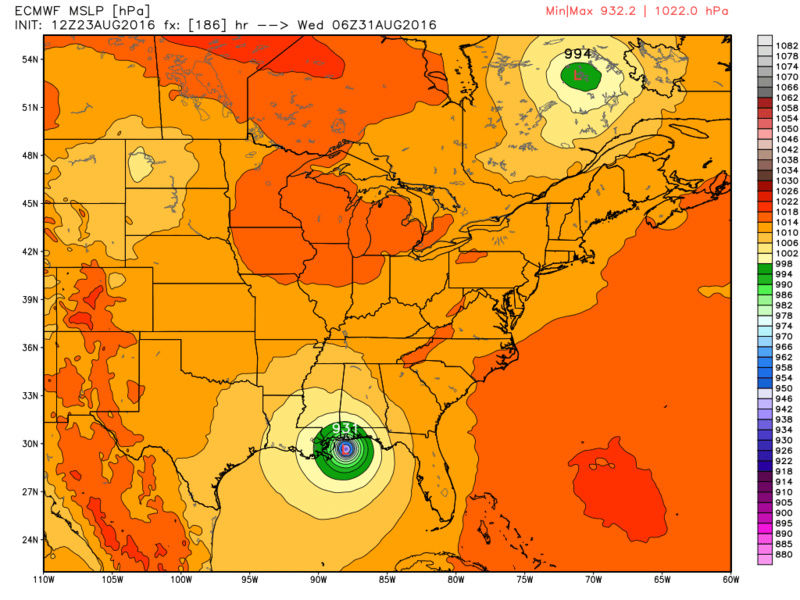
That would make it a strong Cat 4/borderline 5.jmanley32 wrote:damn beat me to it nutley by seconds lol, yeah got my wxbll back its actually 931mb at landfall jesus what is that cat 3+?
nutleyblizzard- Senior Enthusiast
- Posts : 1952
Reputation : 41
Join date : 2014-01-30
Age : 58
Location : Nutley, new jersey
Re: 2016 Tropical Cyclone Discussions
![]() by jmanley32 Tue Aug 23, 2016 2:56 pm
by jmanley32 Tue Aug 23, 2016 2:56 pm
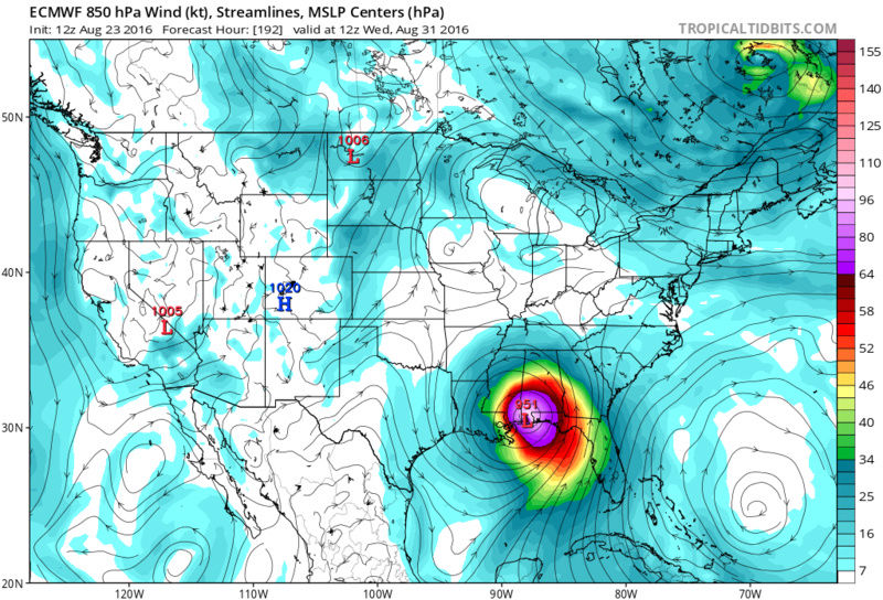
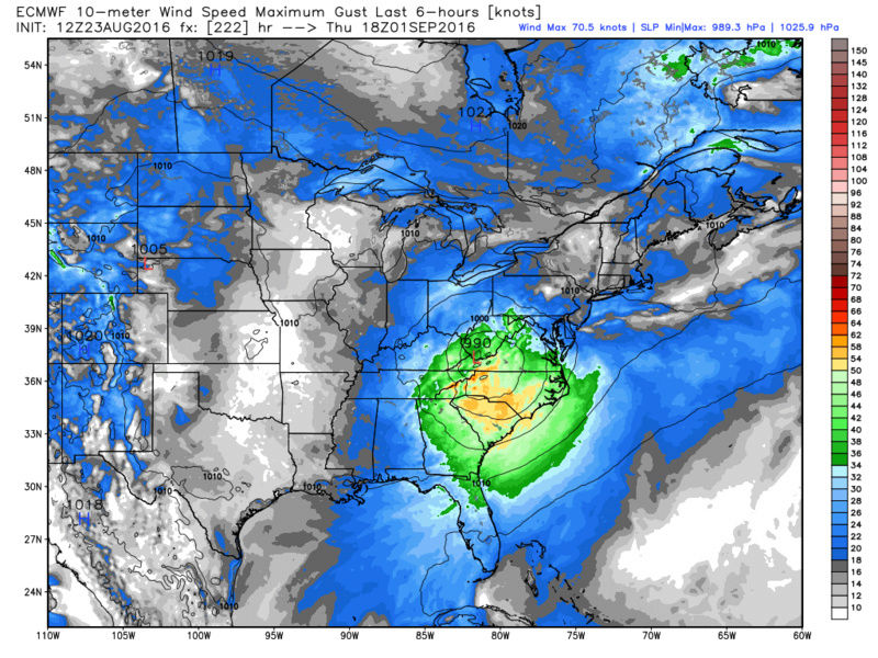
sroc4 wrote:No body is posting it yet but Euro just held serve with the third run in a row with 99L crossing Fla and exploding in the GOM. This run made landfall at 937MB!!!! near the Miss Bama coast....an absolute BEAST!!
look up sroc we posted it lol, will all depend on that ridge i guess as to how far west it gets before turning N or NE in the GOM.
jmanley32- Senior Enthusiast
- Posts : 20516
Reputation : 108
Join date : 2013-12-12
Age : 42
Location : Yonkers, NY
Re: 2016 Tropical Cyclone Discussions
![]() by jmanley32 Tue Aug 23, 2016 2:58 pm
by jmanley32 Tue Aug 23, 2016 2:58 pm
jmanley32- Senior Enthusiast
- Posts : 20516
Reputation : 108
Join date : 2013-12-12
Age : 42
Location : Yonkers, NY
Re: 2016 Tropical Cyclone Discussions
![]() by sroc4 Tue Aug 23, 2016 3:00 pm
by sroc4 Tue Aug 23, 2016 3:00 pm
jmanley32 wrote:sroc4 wrote:No body is posting it yet but Euro just held serve with the third run in a row with 99L crossing Fla and exploding in the GOM. This run made landfall at 937MB!!!! near the Miss Bama coast....an absolute BEAST!!
look up sroc we posted it lol, will all depend on that ridge i guess as to how far west it gets before turning N or NE in the GOM.
Yeah as of me writing that nothing was posted yet. I took a break to text back and fourth with a buddy of mine about it an when I hit send you guys were all over it. lol
_________________
"In weather and in life, there's no winning and losing; there's only winning and learning."
WINTER 2012/2013 TOTALS 43.65"WINTER 2017/2018 TOTALS 62.85" WINTER 2022/2023 TOTALS 4.9"
WINTER 2013/2014 TOTALS 64.85"WINTER 2018/2019 TOTALS 14.25" WINTER 2023/2024 TOTALS 13.1"
WINTER 2014/2015 TOTALS 71.20"WINTER 2019/2020 TOTALS 6.35"
WINTER 2015/2016 TOTALS 35.00"WINTER 2020/2021 TOTALS 37.75"
WINTER 2016/2017 TOTALS 42.25"WINTER 2021/2022 TOTALS 31.65"
sroc4- Admin
- Posts : 8331
Reputation : 301
Join date : 2013-01-07
Location : Wading River, LI
Re: 2016 Tropical Cyclone Discussions
![]() by jmanley32 Tue Aug 23, 2016 3:02 pm
by jmanley32 Tue Aug 23, 2016 3:02 pm
jmanley32- Senior Enthusiast
- Posts : 20516
Reputation : 108
Join date : 2013-12-12
Age : 42
Location : Yonkers, NY
Re: 2016 Tropical Cyclone Discussions
![]() by jmanley32 Tue Aug 23, 2016 3:04 pm
by jmanley32 Tue Aug 23, 2016 3:04 pm
jmanley32- Senior Enthusiast
- Posts : 20516
Reputation : 108
Join date : 2013-12-12
Age : 42
Location : Yonkers, NY
Re: 2016 Tropical Cyclone Discussions
![]() by sroc4 Tue Aug 23, 2016 3:05 pm
by sroc4 Tue Aug 23, 2016 3:05 pm
_________________
"In weather and in life, there's no winning and losing; there's only winning and learning."
WINTER 2012/2013 TOTALS 43.65"WINTER 2017/2018 TOTALS 62.85" WINTER 2022/2023 TOTALS 4.9"
WINTER 2013/2014 TOTALS 64.85"WINTER 2018/2019 TOTALS 14.25" WINTER 2023/2024 TOTALS 13.1"
WINTER 2014/2015 TOTALS 71.20"WINTER 2019/2020 TOTALS 6.35"
WINTER 2015/2016 TOTALS 35.00"WINTER 2020/2021 TOTALS 37.75"
WINTER 2016/2017 TOTALS 42.25"WINTER 2021/2022 TOTALS 31.65"
sroc4- Admin
- Posts : 8331
Reputation : 301
Join date : 2013-01-07
Location : Wading River, LI
Re: 2016 Tropical Cyclone Discussions
![]() by nutleyblizzard Tue Aug 23, 2016 3:07 pm
by nutleyblizzard Tue Aug 23, 2016 3:07 pm
Crap. If the EURO run played out like that, it would washout our Labor Day weekend.jmanley32 wrote:I know this is getting to fantasy land but it intensifies a bit over land as it heads into the areea?!
nutleyblizzard- Senior Enthusiast
- Posts : 1952
Reputation : 41
Join date : 2014-01-30
Age : 58
Location : Nutley, new jersey
Re: 2016 Tropical Cyclone Discussions
![]() by jmanley32 Tue Aug 23, 2016 3:07 pm
by jmanley32 Tue Aug 23, 2016 3:07 pm
jmanley32- Senior Enthusiast
- Posts : 20516
Reputation : 108
Join date : 2013-12-12
Age : 42
Location : Yonkers, NY
Re: 2016 Tropical Cyclone Discussions
![]() by jmanley32 Tue Aug 23, 2016 3:08 pm
by jmanley32 Tue Aug 23, 2016 3:08 pm
sroc4 wrote:To top it all off it brings the Low off the Delmarva and to the bench mark for some epic flooding for the Mid atlantic and NE
Strong TS force winds at leat gusts too on that run, beastly to millions.
jmanley32- Senior Enthusiast
- Posts : 20516
Reputation : 108
Join date : 2013-12-12
Age : 42
Location : Yonkers, NY
Re: 2016 Tropical Cyclone Discussions
![]() by Math23x7 Tue Aug 23, 2016 3:09 pm
by Math23x7 Tue Aug 23, 2016 3:09 pm
Math23x7- Wx Statistician Guru
- Posts : 2379
Reputation : 68
Join date : 2013-01-08
Re: 2016 Tropical Cyclone Discussions
![]() by sroc4 Tue Aug 23, 2016 3:11 pm
by sroc4 Tue Aug 23, 2016 3:11 pm
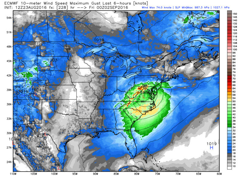
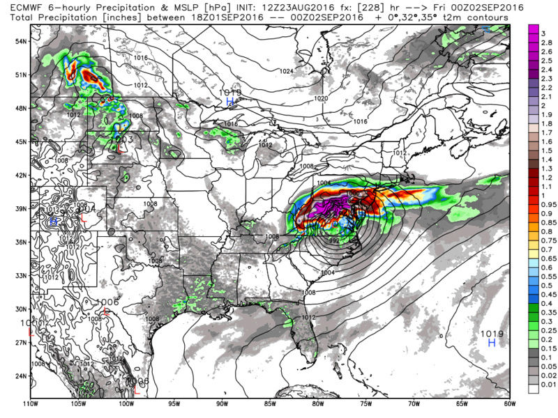
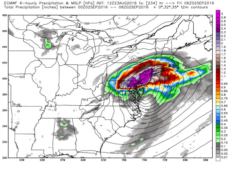
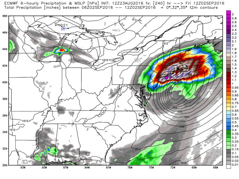
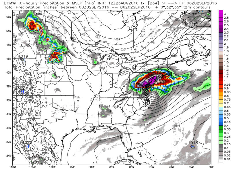
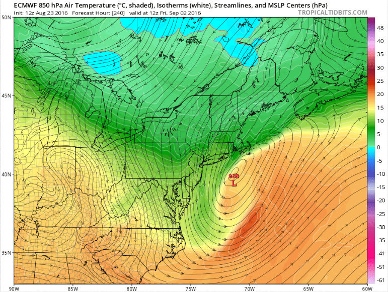
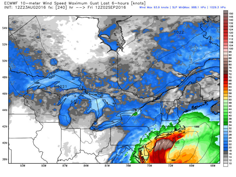
Math23x7 wrote:Here is hr 240 of the 12Z EURO with the 988 mb low just inside the 40-70 BM we use during the snow season. Speaking of the snow season, look at northern Maine with the 0C 850 mb temperatures. The season is right around the corner!
I like where your head is at Mikey!!
_________________
"In weather and in life, there's no winning and losing; there's only winning and learning."
WINTER 2012/2013 TOTALS 43.65"WINTER 2017/2018 TOTALS 62.85" WINTER 2022/2023 TOTALS 4.9"
WINTER 2013/2014 TOTALS 64.85"WINTER 2018/2019 TOTALS 14.25" WINTER 2023/2024 TOTALS 13.1"
WINTER 2014/2015 TOTALS 71.20"WINTER 2019/2020 TOTALS 6.35"
WINTER 2015/2016 TOTALS 35.00"WINTER 2020/2021 TOTALS 37.75"
WINTER 2016/2017 TOTALS 42.25"WINTER 2021/2022 TOTALS 31.65"
sroc4- Admin
- Posts : 8331
Reputation : 301
Join date : 2013-01-07
Location : Wading River, LI
Re: 2016 Tropical Cyclone Discussions
![]() by jmanley32 Tue Aug 23, 2016 3:11 pm
by jmanley32 Tue Aug 23, 2016 3:11 pm
jmanley32- Senior Enthusiast
- Posts : 20516
Reputation : 108
Join date : 2013-12-12
Age : 42
Location : Yonkers, NY
Page 8 of 33 • 1 ... 5 ... 7, 8, 9 ... 20 ... 33 ![]()
|
|
|