
 Search
2016 Tropical Cyclone Discussions
Page 9 of 33 •  1 ... 6 ... 8, 9, 10 ... 21 ... 33
 ![]()
Re: 2016 Tropical Cyclone Discussions
![]() by sroc4 Tue Aug 23, 2016 3:11 pm
by sroc4 Tue Aug 23, 2016 3:11 pm
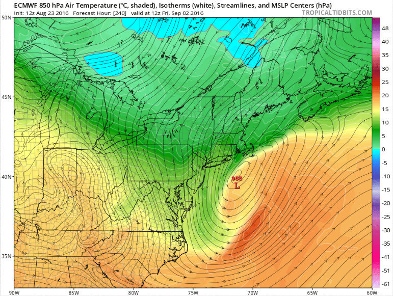
Math23x7 wrote:Here is hr 240 of the 12Z EURO with the 988 mb low just inside the 40-70 BM we use during the snow season. Speaking of the snow season, look at northern Maine with the 0C 850 mb temperatures. The season is right around the corner!
I like where your head is at Mikey!!
sroc4- Admin

- Posts : 8331
Join date : 2013-01-07
Re: 2016 Tropical Cyclone Discussions
![]() by jmanley32 Tue Aug 23, 2016 3:11 pm
by jmanley32 Tue Aug 23, 2016 3:11 pm
jmanley32- Senior Enthusiast

- Posts : 20513
Join date : 2013-12-12
Re: 2016 Tropical Cyclone Discussions
![]() by jmanley32 Tue Aug 23, 2016 3:14 pm
by jmanley32 Tue Aug 23, 2016 3:14 pm

jmanley32- Senior Enthusiast
- Posts : 20513
Reputation : 108
Join date : 2013-12-12
Age : 42
Location : Yonkers, NY
Re: 2016 Tropical Cyclone Discussions
![]() by jmanley32 Tue Aug 23, 2016 3:22 pm
by jmanley32 Tue Aug 23, 2016 3:22 pm
jmanley32- Senior Enthusiast
- Posts : 20513
Reputation : 108
Join date : 2013-12-12
Age : 42
Location : Yonkers, NY
Re: 2016 Tropical Cyclone Discussions
![]() by amugs Tue Aug 23, 2016 3:24 pm
by amugs Tue Aug 23, 2016 3:24 pm
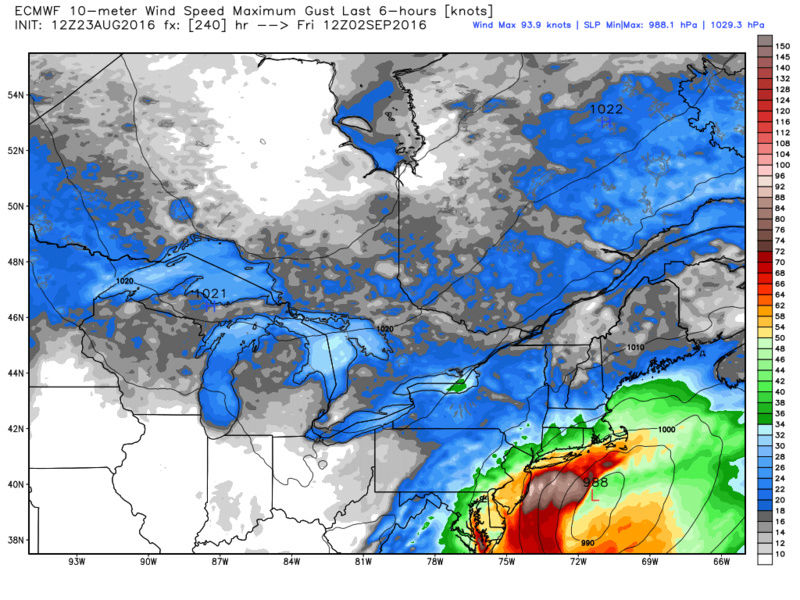
Cat 4 as itslams into the Gulf New Orleans and LA wil be bldemolished by this beast if they get hit.
Then it climbs inland to come back out off the VA coast and boom it feathers over the bathtub waters by us and becomes a trop storm again. Thus would be unbelievable if it were to occur imo.
Jesus this is a scary track for the gulf states.
_________________
Mugs
AKA:King: Snow Weenie
Self Proclaimed
WINTER 2014-15 : 55.12" +.02 for 6 coatings (avg. 35")
WINTER 2015-16 Total - 29.8" (Avg 35")
WINTER 2016-17 : 39.5" so far

amugs- Advanced Forecaster - Mod

- Posts : 15093
Reputation : 213
Join date : 2013-01-07
Age : 54
Location : Hillsdale,NJ
Re: 2016 Tropical Cyclone Discussions
![]() by amugs Tue Aug 23, 2016 3:25 pm
by amugs Tue Aug 23, 2016 3:25 pm
_________________
Mugs
AKA:King: Snow Weenie
Self Proclaimed
WINTER 2014-15 : 55.12" +.02 for 6 coatings (avg. 35")
WINTER 2015-16 Total - 29.8" (Avg 35")
WINTER 2016-17 : 39.5" so far
amugs- Advanced Forecaster - Mod
- Posts : 15093
Reputation : 213
Join date : 2013-01-07
Age : 54
Location : Hillsdale,NJ
Re: 2016 Tropical Cyclone Discussions
![]() by jmanley32 Tue Aug 23, 2016 3:55 pm
by jmanley32 Tue Aug 23, 2016 3:55 pm
yeah it could be less intense but it was amazing to see a run that goes overland so long to still give us quite a storm. Not like the gulf but still.amugs wrote:Jman may let off the gas slightly but if it does as forecasted this is a monster strom.
jmanley32- Senior Enthusiast
- Posts : 20513
Reputation : 108
Join date : 2013-12-12
Age : 42
Location : Yonkers, NY
Re: 2016 Tropical Cyclone Discussions
![]() by jmanley32 Tue Aug 23, 2016 3:58 pm
by jmanley32 Tue Aug 23, 2016 3:58 pm
jmanley32- Senior Enthusiast
- Posts : 20513
Reputation : 108
Join date : 2013-12-12
Age : 42
Location : Yonkers, NY
Re: 2016 Tropical Cyclone Discussions
![]() by algae888 Tue Aug 23, 2016 4:25 pm
by algae888 Tue Aug 23, 2016 4:25 pm

algae888- Advanced Forecaster

- Posts : 5311
Reputation : 46
Join date : 2013-02-05
Age : 61
Location : mt. vernon, new york
Re: 2016 Tropical Cyclone Discussions
![]() by jmanley32 Tue Aug 23, 2016 4:37 pm
by jmanley32 Tue Aug 23, 2016 4:37 pm
jmanley32- Senior Enthusiast
- Posts : 20513
Reputation : 108
Join date : 2013-12-12
Age : 42
Location : Yonkers, NY
Re: 2016 Tropical Cyclone Discussions
![]() by Frank_Wx Tue Aug 23, 2016 6:18 pm
by Frank_Wx Tue Aug 23, 2016 6:18 pm
I am considering writing a blog but thinking about waiting 1 more day given the major differences in the models. The environment 99L has to work with is not very favorable. First, there is an area of dry air ahead of 99L it has to get through. The wave will survive and likely track north of Hispaniola into the Bahamas/Florida region. Since it will remain a weak wave until then, it's likely to get stuck under an upper level ridge that looks to station itself over the east coast this weekend (image 1). Southeast of this ridge is an upper level trough that will send wind shear (image 2) and dry air into the Florida/Bahamas region.
As with any tropical system this is very time sensitive. Perhaps it survives the second round of dry air and stalls under the ridge. That could give it time to rapidly intensify into a potent cyclone and track west into the Gulf. Maybe it gets stuck near one of the islands and avoids the wind shear. There are many avenues for 99L to take. We're still 3 days away until we truly know what will happen.
1.

2.

_________________
_______________________________________________________________________________________________________
CLICK HERE to view NJ Strong Snowstorm Classifications

Frank_Wx- Godzilla Seeker
- Posts : 21305
Reputation : 328
Join date : 2013-01-05
Age : 31
Location : Jersey City, NJ -

Re: 2016 Tropical Cyclone Discussions
![]() by Frank_Wx Tue Aug 23, 2016 6:24 pm
by Frank_Wx Tue Aug 23, 2016 6:24 pm
_________________
_______________________________________________________________________________________________________
CLICK HERE to view NJ Strong Snowstorm Classifications
Frank_Wx- Godzilla Seeker
- Posts : 21305
Reputation : 328
Join date : 2013-01-05
Age : 31
Location : Jersey City, NJ -
Re: 2016 Tropical Cyclone Discussions
![]() by amugs Tue Aug 23, 2016 6:27 pm
by amugs Tue Aug 23, 2016 6:27 pm

_________________
Mugs
AKA:King: Snow Weenie
Self Proclaimed
WINTER 2014-15 : 55.12" +.02 for 6 coatings (avg. 35")
WINTER 2015-16 Total - 29.8" (Avg 35")
WINTER 2016-17 : 39.5" so far
amugs- Advanced Forecaster - Mod
- Posts : 15093
Reputation : 213
Join date : 2013-01-07
Age : 54
Location : Hillsdale,NJ
Re: 2016 Tropical Cyclone Discussions
![]() by amugs Tue Aug 23, 2016 6:30 pm
by amugs Tue Aug 23, 2016 6:30 pm
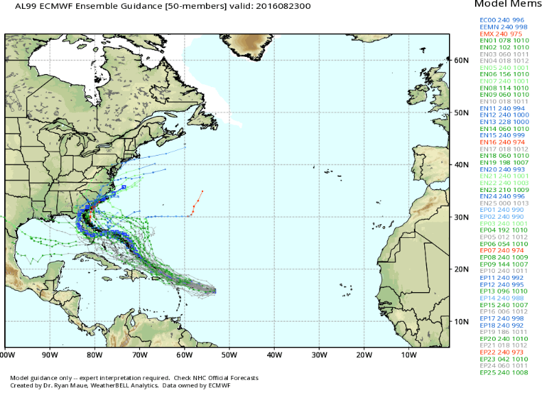
Just for you JMANjmanley32 wrote:Apparently but haven't looked yet 38 or more of euro ensembles are on board. 25 around fl at hr 144.
_________________
Mugs
AKA:King: Snow Weenie
Self Proclaimed
WINTER 2014-15 : 55.12" +.02 for 6 coatings (avg. 35")
WINTER 2015-16 Total - 29.8" (Avg 35")
WINTER 2016-17 : 39.5" so far
amugs- Advanced Forecaster - Mod
- Posts : 15093
Reputation : 213
Join date : 2013-01-07
Age : 54
Location : Hillsdale,NJ
Re: 2016 Tropical Cyclone Discussions
![]() by Math23x7 Tue Aug 23, 2016 6:44 pm
by Math23x7 Tue Aug 23, 2016 6:44 pm
amugs wrote:Just for you JMANjmanley32 wrote:Apparently but haven't looked yet 38 or more of euro ensembles are on board. 25 around fl at hr 144.
That's the 0Z 8/23 EURO ENS. Did you intend on posting the 12Z 8/23 EURO ENS?
Math23x7- Wx Statistician Guru

- Posts : 2379
Reputation : 68
Join date : 2013-01-08
Re: 2016 Tropical Cyclone Discussions
![]() by sroc4 Tue Aug 23, 2016 7:07 pm
by sroc4 Tue Aug 23, 2016 7:07 pm
Frank_Wx wrote:For the sake and livelihood of the people of Louisiana lets hope the EURO is incorrect in its depiction of 99L. A major hurricane affecting that region - after gettings is worst flooding since Katrina - would mean complete devastation.
I am considering writing a blog but thinking about waiting 1 more day given the major differences in the models. The environment 99L has to work with is not very favorable. First, there is an area of dry air ahead of 99L it has to get through. The wave will survive and likely track north of Hispaniola into the Bahamas/Florida region. Since it will remain a weak wave until then, it's likely to get stuck under an upper level ridge that looks to station itself over the east coast this weekend (image 1). Southeast of this ridge is an upper level trough that will send wind shear (image 2) and dry air into the Florida/Bahamas region.
As with any tropical system this is very time sensitive. Perhaps it survives the second round of dry air and stalls under the ridge. That could give it time to rapidly intensify into a potent cyclone and track west into the Gulf. Maybe it gets stuck near one of the islands and avoids the wind shear. There are many avenues for 99L to take. We're still 3 days away until we truly know what will happen.
1.
2.
There are stark differences in how far S and W that upper level trough actually digs, how much shear and how much dry air are involved from Euro to GFS.
_________________
"In weather and in life, there's no winning and losing; there's only winning and learning."
WINTER 2012/2013 TOTALS 43.65"WINTER 2017/2018 TOTALS 62.85" WINTER 2022/2023 TOTALS 4.9"
WINTER 2013/2014 TOTALS 64.85"WINTER 2018/2019 TOTALS 14.25" WINTER 2023/2024 TOTALS 13.1"
WINTER 2014/2015 TOTALS 71.20"WINTER 2019/2020 TOTALS 6.35"
WINTER 2015/2016 TOTALS 35.00"WINTER 2020/2021 TOTALS 37.75"
WINTER 2016/2017 TOTALS 42.25"WINTER 2021/2022 TOTALS 31.65"

sroc4- Admin
- Posts : 8331
Reputation : 301
Join date : 2013-01-07
Location : Wading River, LI
Re: 2016 Tropical Cyclone Discussions
![]() by Frank_Wx Tue Aug 23, 2016 7:23 pm
by Frank_Wx Tue Aug 23, 2016 7:23 pm
sroc4 wrote:Frank_Wx wrote:For the sake and livelihood of the people of Louisiana lets hope the EURO is incorrect in its depiction of 99L. A major hurricane affecting that region - after gettings is worst flooding since Katrina - would mean complete devastation.
I am considering writing a blog but thinking about waiting 1 more day given the major differences in the models. The environment 99L has to work with is not very favorable. First, there is an area of dry air ahead of 99L it has to get through. The wave will survive and likely track north of Hispaniola into the Bahamas/Florida region. Since it will remain a weak wave until then, it's likely to get stuck under an upper level ridge that looks to station itself over the east coast this weekend (image 1). Southeast of this ridge is an upper level trough that will send wind shear (image 2) and dry air into the Florida/Bahamas region.
As with any tropical system this is very time sensitive. Perhaps it survives the second round of dry air and stalls under the ridge. That could give it time to rapidly intensify into a potent cyclone and track west into the Gulf. Maybe it gets stuck near one of the islands and avoids the wind shear. There are many avenues for 99L to take. We're still 3 days away until we truly know what will happen.
1.
2.
There are stark differences in how far S and W that upper level trough actually digs, how much shear and how much dry air are involved from Euro to GFS.
I'm sure. I'm tempted to buy WxBell again so I can see for myself haha.
_________________
_______________________________________________________________________________________________________
CLICK HERE to view NJ Strong Snowstorm Classifications
Frank_Wx- Godzilla Seeker
- Posts : 21305
Reputation : 328
Join date : 2013-01-05
Age : 31
Location : Jersey City, NJ -
Re: 2016 Tropical Cyclone Discussions
![]() by Joe Snow Tue Aug 23, 2016 7:44 pm
by Joe Snow Tue Aug 23, 2016 7:44 pm

Joe Snow- Pro Enthusiast

- Posts : 924
Reputation : 7
Join date : 2014-02-12
Age : 62
Location : Sanford Florida, Fmrly Kings Park, NY
Re: 2016 Tropical Cyclone Discussions
![]() by sroc4 Tue Aug 23, 2016 9:23 pm
by sroc4 Tue Aug 23, 2016 9:23 pm
http://www.tropicaltidbits.com
_________________
"In weather and in life, there's no winning and losing; there's only winning and learning."
WINTER 2012/2013 TOTALS 43.65"WINTER 2017/2018 TOTALS 62.85" WINTER 2022/2023 TOTALS 4.9"
WINTER 2013/2014 TOTALS 64.85"WINTER 2018/2019 TOTALS 14.25" WINTER 2023/2024 TOTALS 13.1"
WINTER 2014/2015 TOTALS 71.20"WINTER 2019/2020 TOTALS 6.35"
WINTER 2015/2016 TOTALS 35.00"WINTER 2020/2021 TOTALS 37.75"
WINTER 2016/2017 TOTALS 42.25"WINTER 2021/2022 TOTALS 31.65"
sroc4- Admin
- Posts : 8331
Reputation : 301
Join date : 2013-01-07
Location : Wading River, LI
Re: 2016 Tropical Cyclone Discussions
![]() by Joe Snow Tue Aug 23, 2016 9:42 pm
by Joe Snow Tue Aug 23, 2016 9:42 pm
http://videowall.accuweather.com/detail/videos/experts/video/2430839568001/depression-or-storm-likely-to-form-in-next-24-hours?autoStart=true
Joe Snow- Pro Enthusiast
- Posts : 924
Reputation : 7
Join date : 2014-02-12
Age : 62
Location : Sanford Florida, Fmrly Kings Park, NY
Re: 2016 Tropical Cyclone Discussions
![]() by jmanley32 Tue Aug 23, 2016 9:46 pm
by jmanley32 Tue Aug 23, 2016 9:46 pm
jmanley32- Senior Enthusiast
- Posts : 20513
Reputation : 108
Join date : 2013-12-12
Age : 42
Location : Yonkers, NY
Re: 2016 Tropical Cyclone Discussions
![]() by Snow88 Tue Aug 23, 2016 9:54 pm
by Snow88 Tue Aug 23, 2016 9:54 pm

Snow88- Senior Enthusiast
- Posts : 2193
Reputation : 4
Join date : 2013-01-09
Age : 35
Location : Brooklyn, NY
Re: 2016 Tropical Cyclone Discussions
![]() by Frank_Wx Tue Aug 23, 2016 9:57 pm
by Frank_Wx Tue Aug 23, 2016 9:57 pm
sroc4 wrote:Levi Cowin IMHO offers some of the best tropical analysis around. Check it out. He really lays it out clear and concise and covers everything we've discussed today.
http://www.tropicaltidbits.com
Fantastic presentation. Levi is the best tropical expert I've seen.
The differences between the EURO and GFS in the short term are staggering. I must say, even looking at IR imagery now, I think EURO is closer to its current form. The wind shear Levi spoke about from the mid-level trough I think could dissipate thanks to Fiona. She's generally moving west toward the coast right as that trough from the mid Atlantic tries to come south. She's kinda in the way then a ridge ends up taking hold over the east.
I can definitely see why the EURO is correct. Oh boy...
_________________
_______________________________________________________________________________________________________
CLICK HERE to view NJ Strong Snowstorm Classifications
Frank_Wx- Godzilla Seeker
- Posts : 21305
Reputation : 328
Join date : 2013-01-05
Age : 31
Location : Jersey City, NJ -
Re: 2016 Tropical Cyclone Discussions
![]() by Frank_Wx Tue Aug 23, 2016 9:59 pm
by Frank_Wx Tue Aug 23, 2016 9:59 pm
Snow88 wrote:As of right now, this doesnt look to have a big impact on the east coast
This was never an east coast threat. We're going to end up with temps in the 90s this weekend thanks to that ridge. That said, if invest 99 does become a hurricane and tracks into the Gulf, we can't rule out a recurve of its remnants heading this way
_________________
_______________________________________________________________________________________________________
CLICK HERE to view NJ Strong Snowstorm Classifications
Frank_Wx- Godzilla Seeker
- Posts : 21305
Reputation : 328
Join date : 2013-01-05
Age : 31
Location : Jersey City, NJ -
Re: 2016 Tropical Cyclone Discussions
![]() by Snow88 Tue Aug 23, 2016 10:07 pm
by Snow88 Tue Aug 23, 2016 10:07 pm
Frank_Wx wrote:Snow88 wrote:As of right now, this doesnt look to have a big impact on the east coast
This was never an east coast threat. We're going to end up with temps in the 90s this weekend thanks to that ridge. That said, if invest 99 does become a hurricane and tracks into the Gulf, we can't rule out a recurve of its remnants heading this way
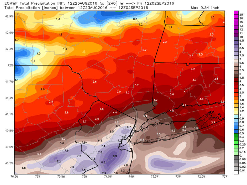
Like the Euro
6+ inches of rain for the area
Snow88- Senior Enthusiast
- Posts : 2193
Reputation : 4
Join date : 2013-01-09
Age : 35
Location : Brooklyn, NY
Re: 2016 Tropical Cyclone Discussions
![]() by Frank_Wx Tue Aug 23, 2016 10:56 pm
by Frank_Wx Tue Aug 23, 2016 10:56 pm

_________________
_______________________________________________________________________________________________________
CLICK HERE to view NJ Strong Snowstorm Classifications
Frank_Wx- Godzilla Seeker
- Posts : 21305
Reputation : 328
Join date : 2013-01-05
Age : 31
Location : Jersey City, NJ -
Re: 2016 Tropical Cyclone Discussions
![]() by Snow88 Tue Aug 23, 2016 11:05 pm
by Snow88 Tue Aug 23, 2016 11:05 pm
Snow88- Senior Enthusiast
- Posts : 2193
Reputation : 4
Join date : 2013-01-09
Age : 35
Location : Brooklyn, NY
Page 9 of 33 • 1 ... 6 ... 8, 9, 10 ... 21 ... 33 ![]()
|
|
|