
 Search
Hurricane Hermine Discussion
Page 21 of 40 •  1 ... 12 ... 20, 21, 22 ... 30 ... 40
 ![]()
Re: Hurricane Hermine Discussion
![]() by NjWeatherGuy Thu Sep 01, 2016 7:48 pm
by NjWeatherGuy Thu Sep 01, 2016 7:48 pm
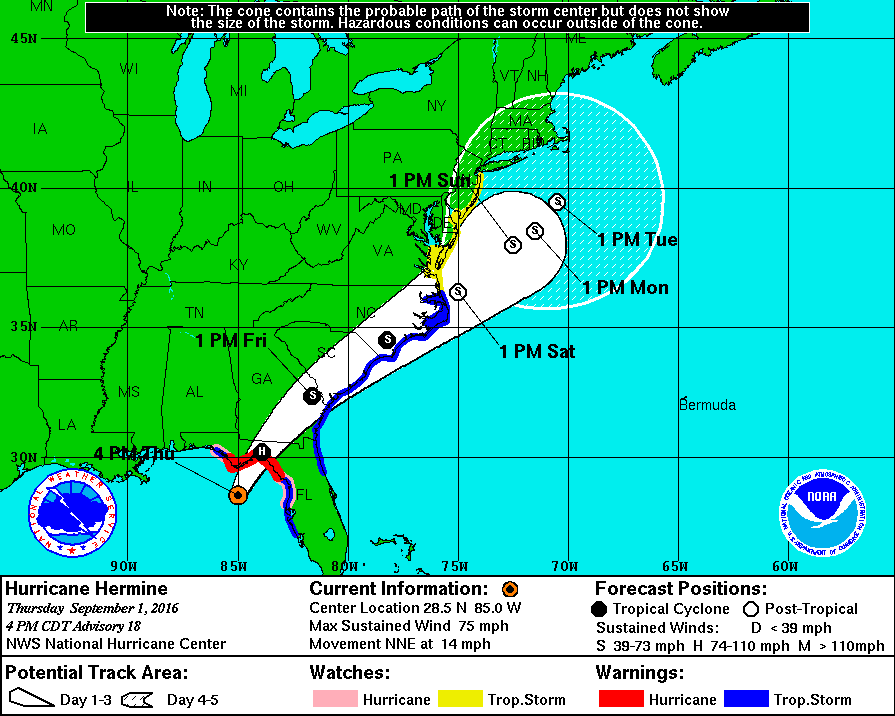
rb924119 wrote:Here's my current thinking regarding track. Intensity I'm thinking strong TS to Cat 1, but not necessarily entirely tropical.
By the way, I did this for work, so PLEASE do not share this image lol

Interesting, with the way some trends have been, would have figured it would have been more offshore, but i guess thats your hunch. Im not sure what I think yet, I still think its 50/50 further away mainly beach effects or closer that it could affect inland with rain and wind.
NjWeatherGuy- Advanced Forecaster

- Posts : 4100
Join date : 2013-01-06
Re: Hurricane Hermine Discussion
![]() by Guest Thu Sep 01, 2016 7:52 pm
by Guest Thu Sep 01, 2016 7:52 pm
NjWeatherGuy wrote:syosnow94 wrote:amugs wrote:
OH BOY !!
Its going to weaken and lose some moisture when it heads inland, assuming it even affects us, which it still may not, it may restregnthen over water and become extratropical where most of the rain and wind is usually broadly to the NW of center.
My point exactly. We will be on the NW side in close proximity (inside the BM or right on it) for 3 to 4 days possibly according to the latest guidance. We should be getting crushed by rainfall over DAYS!!! The totals should be extreme IMO.
Guest- Guest
Re: Hurricane Hermine Discussion
![]() by Guest Thu Sep 01, 2016 7:53 pm
by Guest Thu Sep 01, 2016 7:53 pm
Frank_Wx wrote:5

Gorgeous. Look at the outer bands wrapping up tightly around the eye. This thing is gonna be 100 MPH at 11:00 advisory.
Guest- Guest
Re: Hurricane Hermine Discussion
![]() by jmanley32 Thu Sep 01, 2016 7:54 pm
by jmanley32 Thu Sep 01, 2016 7:54 pm
syosnow94 wrote:NjWeatherGuy wrote:syosnow94 wrote:amugs wrote:
OH BOY !!
Its going to weaken and lose some moisture when it heads inland, assuming it even affects us, which it still may not, it may restregnthen over water and become extratropical where most of the rain and wind is usually broadly to the NW of center.
My point exactly. We will be on the NW side in close proximity (inside the BM or right on it) for 3 to 4 days possibly according to the latest guidance. We should be getting crushed by rainfall over DAYS!!! The totals should be extreme IMO.
Winds tend to be in that quad too. We will see, I am with you syo but are you sure we arent wishcasting lol

jmanley32- Senior Enthusiast

- Posts : 20512
Reputation : 108
Join date : 2013-12-12
Age : 42
Location : Yonkers, NY
Re: Hurricane Hermine Discussion
![]() by jmanley32 Thu Sep 01, 2016 7:56 pm
by jmanley32 Thu Sep 01, 2016 7:56 pm
Location: 29.1°N 84.8°W
Moving: NNE at 14 mph
Min pressure: 983 mb
Max sustained: 80 mph
jmanley32- Senior Enthusiast
- Posts : 20512
Reputation : 108
Join date : 2013-12-12
Age : 42
Location : Yonkers, NY
Re: Hurricane Hermine Discussion
![]() by Guest Thu Sep 01, 2016 8:00 pm
by Guest Thu Sep 01, 2016 8:00 pm
jmanley32 wrote:syosnow94 wrote:NjWeatherGuy wrote:syosnow94 wrote:amugs wrote:
OH BOY !!
Its going to weaken and lose some moisture when it heads inland, assuming it even affects us, which it still may not, it may restregnthen over water and become extratropical where most of the rain and wind is usually broadly to the NW of center.
My point exactly. We will be on the NW side in close proximity (inside the BM or right on it) for 3 to 4 days possibly according to the latest guidance. We should be getting crushed by rainfall over DAYS!!! The totals should be extreme IMO.
Winds tend to be in that quad too. We will see, I am with you syo but are you sure we arent wishcasting lol
Honest to God Jman if this was purely a nor'easter traveling from the Delmarva to the BM over 3 or 4 days we would be talking about rainfall amounts approaching double digits. This thing is TROPICAL with way more precipitable water available due to the tropical airmass. I'm simply saying that IF this thing travels as advertised how could we not see those kind of amounts. I'm not talking wind. Just rain. I'm NO EXPERT, but It flies in the face of everything we've ever heard about the position of storms up here.
Guest- Guest
Re: Hurricane Hermine Discussion
![]() by Guest Thu Sep 01, 2016 8:02 pm
by Guest Thu Sep 01, 2016 8:02 pm
Guest- Guest
Re: Hurricane Hermine Discussion
![]() by jmanley32 Thu Sep 01, 2016 8:06 pm
by jmanley32 Thu Sep 01, 2016 8:06 pm
syosnow94 wrote:Cone hasn't changed with latest advisory, and look at the SST's off of Virginia Capes up to BM!!! It's a bathtub for this thing to re-strengthen combined with the jet streak.
I mentioned it earlier, cone only changes at full advisories, at 5am, 11am, 5pm and 11pm (If there is a change). And I expect 11pm the cone to change in some way shape or form. And I agree about the rain but we would also be in a large portion of the wind area, but this may have to come a bit further north, watching the model runs most of the precip stays off shore and then as it stalls all the precip tights around it well out in the ocean. But that is all very subject to change.
jmanley32- Senior Enthusiast
- Posts : 20512
Reputation : 108
Join date : 2013-12-12
Age : 42
Location : Yonkers, NY
Re: Hurricane Hermine Discussion
![]() by Frank_Wx Thu Sep 01, 2016 8:20 pm
by Frank_Wx Thu Sep 01, 2016 8:20 pm
That said, I continue to let people know to prepare for the worst especially if you live along the coast. There is no excuse to take that chance it completely goes out to sea. I firmly believe surge will be an issue no matter what. Wind and rain is the tough forecast at this time.
I'm telling friends and family 2 inches of rain with sustained winds between 25-30 and gusts near 40mph. Also letting them know potential exists for 3+ inches of rain and sustained winds near 45 and gusts as high as 70mph.
Coast is a different story. Worst case scenario for you could be half a foot of rain and hurricane force winds.
Since I'm working from home tomorrow I'll have an update out in mid afternoon
_________________
_______________________________________________________________________________________________________
CLICK HERE to view NJ Strong Snowstorm Classifications

Frank_Wx- Godzilla Seeker

- Posts : 21305
Reputation : 328
Join date : 2013-01-05
Age : 31
Location : Jersey City, NJ -

Re: Hurricane Hermine Discussion
![]() by aiannone Thu Sep 01, 2016 8:27 pm
by aiannone Thu Sep 01, 2016 8:27 pm
Cedar Key, FL cam!
_________________
-Alex Iannone-

aiannone- Senior Enthusiast - Mod

- Posts : 4813
Reputation : 92
Join date : 2013-01-07
Location : Saint James, LI (Northwest Suffolk Co.)
Re: Hurricane Hermine Discussion
![]() by jmanley32 Thu Sep 01, 2016 8:28 pm
by jmanley32 Thu Sep 01, 2016 8:28 pm
This is all nj or is it also nyc area etcFrank_Wx wrote:I am going to hold off on the 2nd blog tonight. Not much has changed with models compared to yesterday. I want to see another round of suites before analyzing.
That said, I continue to let people know to prepare for the worst especially if you live along the coast. There is no excuse to take that chance it completely goes out to sea. I firmly believe surge will be an issue no matter what. Wind and rain is the tough forecast at this time.
I'm telling friends and family 2 inches of rain with sustained winds between 25-30 and gusts near 40mph. Also letting them know potential exists for 3+ inches of rain and sustained winds near 45 and gusts as high as 70mph.
Coast is a different story. Worst case scenario for you could be half a foot of rain and hurricane force winds.
Since I'm working from home tomorrow I'll have an update out in mid afternoon
Wanna know if I should tell same thing. Not on immediate Coast so high end prolly not likely. Dn now I gotta wait for ur expert opinion till tomorrow lol. Have a gr8 night. I'll b watch the gfs see euro in morning.
jmanley32- Senior Enthusiast
- Posts : 20512
Reputation : 108
Join date : 2013-12-12
Age : 42
Location : Yonkers, NY
Re: Hurricane Hermine Discussion
![]() by aiannone Thu Sep 01, 2016 8:33 pm
by aiannone Thu Sep 01, 2016 8:33 pm

_________________
-Alex Iannone-
aiannone- Senior Enthusiast - Mod
- Posts : 4813
Reputation : 92
Join date : 2013-01-07
Location : Saint James, LI (Northwest Suffolk Co.)
Re: Hurricane Hermine Discussion
![]() by jmanley32 Thu Sep 01, 2016 8:34 pm
by jmanley32 Thu Sep 01, 2016 8:34 pm
Interesting, but will the 00z models have that ingested as its not quite there yet, or if it is we just havent been advised yet.aiannone wrote:
jmanley32- Senior Enthusiast
- Posts : 20512
Reputation : 108
Join date : 2013-12-12
Age : 42
Location : Yonkers, NY
Re: Hurricane Hermine Discussion
![]() by sroc4 Thu Sep 01, 2016 8:40 pm
by sroc4 Thu Sep 01, 2016 8:40 pm
_________________
"In weather and in life, there's no winning and losing; there's only winning and learning."
WINTER 2012/2013 TOTALS 43.65"WINTER 2017/2018 TOTALS 62.85" WINTER 2022/2023 TOTALS 4.9"
WINTER 2013/2014 TOTALS 64.85"WINTER 2018/2019 TOTALS 14.25" WINTER 2023/2024 TOTALS 13.1"
WINTER 2014/2015 TOTALS 71.20"WINTER 2019/2020 TOTALS 6.35"
WINTER 2015/2016 TOTALS 35.00"WINTER 2020/2021 TOTALS 37.75"
WINTER 2016/2017 TOTALS 42.25"WINTER 2021/2022 TOTALS 31.65"

sroc4- Admin
- Posts : 8331
Reputation : 301
Join date : 2013-01-07
Location : Wading River, LI
Re: Hurricane Hermine Discussion
![]() by Guest Thu Sep 01, 2016 8:40 pm
by Guest Thu Sep 01, 2016 8:40 pm
jmanley32 wrote:syosnow94 wrote:Cone hasn't changed with latest advisory, and look at the SST's off of Virginia Capes up to BM!!! It's a bathtub for this thing to re-strengthen combined with the jet streak.
I mentioned it earlier, cone only changes at full advisories, at 5am, 11am, 5pm and 11pm (If there is a change). And I expect 11pm the cone to change in some way shape or form. And I agree about the rain but we would also be in a large portion of the wind area, but this may have to come a bit further north, watching the model runs most of the precip stays off shore and then as it stalls all the precip tights around it well out in the ocean. But that is all very subject to change.
Jman. I could be wrong but usually as these things interact with the jet at our latitude the storm grows in size and winds and rain extend even further outwards not contract inwards.
Guest- Guest
Re: Hurricane Hermine Discussion
![]() by skinsfan1177 Thu Sep 01, 2016 8:48 pm
by skinsfan1177 Thu Sep 01, 2016 8:48 pm

skinsfan1177- Senior Enthusiast
- Posts : 4485
Reputation : 35
Join date : 2013-01-07
Age : 46
Location : Point Pleasant Boro
Re: Hurricane Hermine Discussion
![]() by jmanley32 Thu Sep 01, 2016 9:02 pm
by jmanley32 Thu Sep 01, 2016 9:02 pm
syosnow94 wrote:jmanley32 wrote:syosnow94 wrote:Cone hasn't changed with latest advisory, and look at the SST's off of Virginia Capes up to BM!!! It's a bathtub for this thing to re-strengthen combined with the jet streak.
I mentioned it earlier, cone only changes at full advisories, at 5am, 11am, 5pm and 11pm (If there is a change). And I expect 11pm the cone to change in some way shape or form. And I agree about the rain but we would also be in a large portion of the wind area, but this may have to come a bit further north, watching the model runs most of the precip stays off shore and then as it stalls all the precip tights around it well out in the ocean. But that is all very subject to change.
Jman. I could be wrong but usually as these things interact with the jet at our latitude the storm grows in size and winds and rain extend even further outwards not contract inwards.
Yeah I am just speaking of the Euro run, it winds it up as we go along in time out to nearly day 8! but at first it expands.
jmanley32- Senior Enthusiast
- Posts : 20512
Reputation : 108
Join date : 2013-12-12
Age : 42
Location : Yonkers, NY
Re: Hurricane Hermine Discussion
![]() by Frank_Wx Thu Sep 01, 2016 9:03 pm
by Frank_Wx Thu Sep 01, 2016 9:03 pm
7am Saturday

7am Sunday

Possible path of Hermine - the closer to the coast the greater the impacts.

_________________
_______________________________________________________________________________________________________
CLICK HERE to view NJ Strong Snowstorm Classifications
Frank_Wx- Godzilla Seeker
- Posts : 21305
Reputation : 328
Join date : 2013-01-05
Age : 31
Location : Jersey City, NJ -
Re: Hurricane Hermine Discussion
![]() by Frank_Wx Thu Sep 01, 2016 9:07 pm
by Frank_Wx Thu Sep 01, 2016 9:07 pm

_________________
_______________________________________________________________________________________________________
CLICK HERE to view NJ Strong Snowstorm Classifications
Frank_Wx- Godzilla Seeker
- Posts : 21305
Reputation : 328
Join date : 2013-01-05
Age : 31
Location : Jersey City, NJ -
Re: Hurricane Hermine Discussion
![]() by amugs Thu Sep 01, 2016 9:09 pm
by amugs Thu Sep 01, 2016 9:09 pm

_________________
Mugs
AKA:King: Snow Weenie
Self Proclaimed
WINTER 2014-15 : 55.12" +.02 for 6 coatings (avg. 35")
WINTER 2015-16 Total - 29.8" (Avg 35")
WINTER 2016-17 : 39.5" so far

amugs- Advanced Forecaster - Mod
- Posts : 15093
Reputation : 213
Join date : 2013-01-07
Age : 54
Location : Hillsdale,NJ
Re: Hurricane Hermine Discussion
![]() by Frank_Wx Thu Sep 01, 2016 9:14 pm
by Frank_Wx Thu Sep 01, 2016 9:14 pm

_________________
_______________________________________________________________________________________________________
CLICK HERE to view NJ Strong Snowstorm Classifications
Frank_Wx- Godzilla Seeker
- Posts : 21305
Reputation : 328
Join date : 2013-01-05
Age : 31
Location : Jersey City, NJ -
Re: Hurricane Hermine Discussion
![]() by Frank_Wx Thu Sep 01, 2016 9:15 pm
by Frank_Wx Thu Sep 01, 2016 9:15 pm
http://polar.ncep.noaa.gov/waves/viewer.shtml?-multi_2-latest-hs-US_eastcoast-
_________________
_______________________________________________________________________________________________________
CLICK HERE to view NJ Strong Snowstorm Classifications
Frank_Wx- Godzilla Seeker
- Posts : 21305
Reputation : 328
Join date : 2013-01-05
Age : 31
Location : Jersey City, NJ -
Re: Hurricane Hermine Discussion
![]() by frank 638 Thu Sep 01, 2016 9:17 pm
by frank 638 Thu Sep 01, 2016 9:17 pm
frank 638- Senior Enthusiast
- Posts : 2824
Reputation : 37
Join date : 2016-01-01
Age : 40
Location : bronx ny
Re: Hurricane Hermine Discussion
![]() by Frank_Wx Thu Sep 01, 2016 9:17 pm
by Frank_Wx Thu Sep 01, 2016 9:17 pm
7 meters is like 20 feet
_________________
_______________________________________________________________________________________________________
CLICK HERE to view NJ Strong Snowstorm Classifications
Frank_Wx- Godzilla Seeker
- Posts : 21305
Reputation : 328
Join date : 2013-01-05
Age : 31
Location : Jersey City, NJ -
Re: Hurricane Hermine Discussion
![]() by Frank_Wx Thu Sep 01, 2016 9:18 pm
by Frank_Wx Thu Sep 01, 2016 9:18 pm
frank 638 wrote:How much rain will we get for NYC and long island
Thinking 2" but will be more if track is closer to coast
_________________
_______________________________________________________________________________________________________
CLICK HERE to view NJ Strong Snowstorm Classifications
Frank_Wx- Godzilla Seeker
- Posts : 21305
Reputation : 328
Join date : 2013-01-05
Age : 31
Location : Jersey City, NJ -
Re: Hurricane Hermine Discussion
![]() by jmanley32 Thu Sep 01, 2016 9:21 pm
by jmanley32 Thu Sep 01, 2016 9:21 pm
Frank_Wx wrote:Wait - that is in meters. Holy crap.
7 meters is like 20 feet
Holy crap, I am gonna have to try to get down there to see that, may never see that again! But probably not a good idea, nor would they probably allow me onto the beaches. I remember when I was in Bermuda and I cannot recall what hurricane it was but we snuck onto the beach when it closed (hurricane was a cat 3+ I think, and the waves were incredible even inside the reef, outside looked scary. If was only after I tried to go into one and almost got sucked out to sea that I ran back to the resort, I am smarter than that now, I was about 13. It was my cousins fault lol
jmanley32- Senior Enthusiast
- Posts : 20512
Reputation : 108
Join date : 2013-12-12
Age : 42
Location : Yonkers, NY
Page 21 of 40 • 1 ... 12 ... 20, 21, 22 ... 30 ... 40 ![]()
|
|
|