
 Search
Hurricane Hermine Discussion Part 2
Page 9 of 35 •  1 ... 6 ... 8, 9, 10 ... 22 ... 35
 ![]()

sroc4- Admin

- Posts : 8331
Join date : 2013-01-07
Re: Hurricane Hermine Discussion Part 2
![]() by rb924119 Sat Sep 03, 2016 7:22 am
by rb924119 Sat Sep 03, 2016 7:22 am
rb924119- Meteorologist

- Posts : 6890
Join date : 2013-02-06
Re: Hurricane Hermine Discussion Part 2
![]() by rb924119 Sat Sep 03, 2016 7:24 am
by rb924119 Sat Sep 03, 2016 7:24 am
rb924119- Meteorologist
- Posts : 6890
Reputation : 194
Join date : 2013-02-06
Age : 32
Location : Greentown, Pa
Re: Hurricane Hermine Discussion Part 2
![]() by sroc4 Sat Sep 03, 2016 7:26 am
by sroc4 Sat Sep 03, 2016 7:26 am
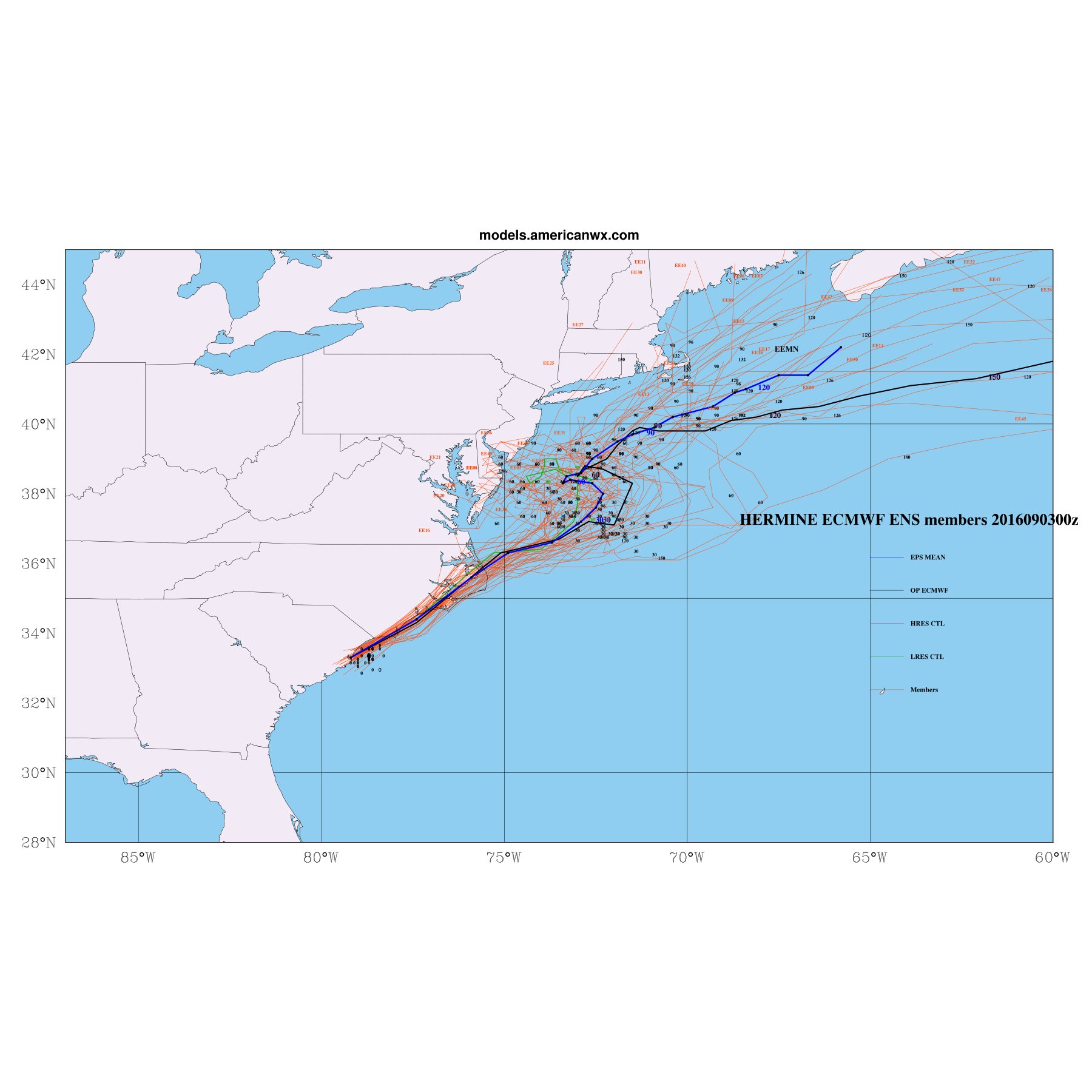
rb924119 wrote:Idk if anybody looked at the Euro ensembles from last night, but there is still a heavy northwest lean that are very close to what the OP had yesterday. I'm not letting my guard down at all with it; this could just be another wobble in the modeling. Waiting on the 12z suite.
Agreed
_________________
"In weather and in life, there's no winning and losing; there's only winning and learning."
WINTER 2012/2013 TOTALS 43.65"WINTER 2017/2018 TOTALS 62.85" WINTER 2022/2023 TOTALS 4.9"
WINTER 2013/2014 TOTALS 64.85"WINTER 2018/2019 TOTALS 14.25" WINTER 2023/2024 TOTALS 13.1"
WINTER 2014/2015 TOTALS 71.20"WINTER 2019/2020 TOTALS 6.35"
WINTER 2015/2016 TOTALS 35.00"WINTER 2020/2021 TOTALS 37.75"
WINTER 2016/2017 TOTALS 42.25"WINTER 2021/2022 TOTALS 31.65"

sroc4- Admin
- Posts : 8331
Reputation : 301
Join date : 2013-01-07
Location : Wading River, LI
Re: Hurricane Hermine Discussion Part 2
![]() by skinsfan1177 Sat Sep 03, 2016 7:37 am
by skinsfan1177 Sat Sep 03, 2016 7:37 am

skinsfan1177- Senior Enthusiast

- Posts : 4485
Reputation : 35
Join date : 2013-01-07
Age : 46
Location : Point Pleasant Boro
Re: Hurricane Hermine Discussion Part 2
![]() by Guest Sat Sep 03, 2016 7:44 am
by Guest Sat Sep 03, 2016 7:44 am
Guest- Guest
Re: Hurricane Hermine Discussion Part 2
![]() by sroc4 Sat Sep 03, 2016 7:45 am
by sroc4 Sat Sep 03, 2016 7:45 am
syosnow94 wrote:Wow. Just woke up and caught up. This sucks. What a tease. I went to bed after reading Frank's blog expecting an epic 3 day event and now POOF gone. BS! What a tease. Really frustrating
Not gone James
_________________
"In weather and in life, there's no winning and losing; there's only winning and learning."
WINTER 2012/2013 TOTALS 43.65"WINTER 2017/2018 TOTALS 62.85" WINTER 2022/2023 TOTALS 4.9"
WINTER 2013/2014 TOTALS 64.85"WINTER 2018/2019 TOTALS 14.25" WINTER 2023/2024 TOTALS 13.1"
WINTER 2014/2015 TOTALS 71.20"WINTER 2019/2020 TOTALS 6.35"
WINTER 2015/2016 TOTALS 35.00"WINTER 2020/2021 TOTALS 37.75"
WINTER 2016/2017 TOTALS 42.25"WINTER 2021/2022 TOTALS 31.65"
sroc4- Admin
- Posts : 8331
Reputation : 301
Join date : 2013-01-07
Location : Wading River, LI
Re: Hurricane Hermine Discussion Part 2
![]() by billg315 Sat Sep 03, 2016 7:49 am
by billg315 Sat Sep 03, 2016 7:49 am

billg315- Advanced Forecaster - Mod

- Posts : 4469
Reputation : 185
Join date : 2015-01-24
Age : 50
Location : Flemington, NJ
Re: Hurricane Hermine Discussion Part 2
![]() by nutleyblizzard Sat Sep 03, 2016 7:52 am
by nutleyblizzard Sat Sep 03, 2016 7:52 am


nutleyblizzard- Senior Enthusiast
- Posts : 1952
Reputation : 41
Join date : 2014-01-30
Age : 58
Location : Nutley, new jersey
Re: Hurricane Hermine Discussion Part 2
![]() by Frank_Wx Sat Sep 03, 2016 7:56 am
by Frank_Wx Sat Sep 03, 2016 7:56 am

_________________
_______________________________________________________________________________________________________
CLICK HERE to view NJ Strong Snowstorm Classifications

Frank_Wx- Godzilla Seeker
- Posts : 21305
Reputation : 328
Join date : 2013-01-05
Age : 31
Location : Jersey City, NJ -

Re: Hurricane Hermine Discussion Part 2
![]() by Frank_Wx Sat Sep 03, 2016 7:58 am
by Frank_Wx Sat Sep 03, 2016 7:58 am
billg315 wrote:Ok here's my first report from the South Jersey coast. The winds have picked up considerably overnight. Right now very gusty winds under a solid cloudy sky. Wind report is NNE at 22 mph. I'll try to update periodically, but if the models worst case scenarios play out I may skedaddle off this island at some point.
Check this out...

_________________
_______________________________________________________________________________________________________
CLICK HERE to view NJ Strong Snowstorm Classifications
Frank_Wx- Godzilla Seeker
- Posts : 21305
Reputation : 328
Join date : 2013-01-05
Age : 31
Location : Jersey City, NJ -
Re: Hurricane Hermine Discussion Part 2
![]() by Frank_Wx Sat Sep 03, 2016 7:59 am
by Frank_Wx Sat Sep 03, 2016 7:59 am
_________________
_______________________________________________________________________________________________________
CLICK HERE to view NJ Strong Snowstorm Classifications
Frank_Wx- Godzilla Seeker
- Posts : 21305
Reputation : 328
Join date : 2013-01-05
Age : 31
Location : Jersey City, NJ -
Re: Hurricane Hermine Discussion Part 2
![]() by rb924119 Sat Sep 03, 2016 8:01 am
by rb924119 Sat Sep 03, 2016 8:01 am
rb924119- Meteorologist
- Posts : 6890
Reputation : 194
Join date : 2013-02-06
Age : 32
Location : Greentown, Pa
Re: Hurricane Hermine Discussion Part 2
![]() by Frank_Wx Sat Sep 03, 2016 8:01 am
by Frank_Wx Sat Sep 03, 2016 8:01 am
_________________
_______________________________________________________________________________________________________
CLICK HERE to view NJ Strong Snowstorm Classifications
Frank_Wx- Godzilla Seeker
- Posts : 21305
Reputation : 328
Join date : 2013-01-05
Age : 31
Location : Jersey City, NJ -
Re: Hurricane Hermine Discussion Part 2
![]() by rb924119 Sat Sep 03, 2016 8:05 am
by rb924119 Sat Sep 03, 2016 8:05 am
rb924119- Meteorologist
- Posts : 6890
Reputation : 194
Join date : 2013-02-06
Age : 32
Location : Greentown, Pa
Re: Hurricane Hermine Discussion Part 2
![]() by skinsfan1177 Sat Sep 03, 2016 8:06 am
by skinsfan1177 Sat Sep 03, 2016 8:06 am
skinsfan1177- Senior Enthusiast
- Posts : 4485
Reputation : 35
Join date : 2013-01-07
Age : 46
Location : Point Pleasant Boro
Re: Hurricane Hermine Discussion Part 2
![]() by Frank_Wx Sat Sep 03, 2016 8:08 am
by Frank_Wx Sat Sep 03, 2016 8:08 am
skinsfan1177 wrote:It looks disorganized
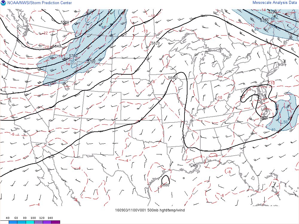
Yes. It actually looks like a Nor'easter. Remember that this system is going from Hurricane to extratropical back to Hurricane (or strong Tropical Storm). Once it's over the Atlantic for a day it will go back to looking warm-core.
_________________
_______________________________________________________________________________________________________
CLICK HERE to view NJ Strong Snowstorm Classifications
Frank_Wx- Godzilla Seeker
- Posts : 21305
Reputation : 328
Join date : 2013-01-05
Age : 31
Location : Jersey City, NJ -
Re: Hurricane Hermine Discussion Part 2
![]() by Frank_Wx Sat Sep 03, 2016 8:09 am
by Frank_Wx Sat Sep 03, 2016 8:09 am
rb924119 wrote:Stole my thunder, Frank lol
It will be interesting to see what happens.
_________________
_______________________________________________________________________________________________________
CLICK HERE to view NJ Strong Snowstorm Classifications
Frank_Wx- Godzilla Seeker
- Posts : 21305
Reputation : 328
Join date : 2013-01-05
Age : 31
Location : Jersey City, NJ -
Re: Hurricane Hermine Discussion Part 2
![]() by NjWeatherGuy Sat Sep 03, 2016 8:13 am
by NjWeatherGuy Sat Sep 03, 2016 8:13 am

NjWeatherGuy- Advanced Forecaster

- Posts : 4100
Reputation : 28
Join date : 2013-01-06
Location : Belle Mead, NJ
Re: Hurricane Hermine Discussion Part 2
![]() by NjWeatherGuy Sat Sep 03, 2016 8:15 am
by NjWeatherGuy Sat Sep 03, 2016 8:15 am
NjWeatherGuy- Advanced Forecaster
- Posts : 4100
Reputation : 28
Join date : 2013-01-06
Location : Belle Mead, NJ
Re: Hurricane Hermine Discussion Part 2
![]() by NjWeatherGuy Sat Sep 03, 2016 8:19 am
by NjWeatherGuy Sat Sep 03, 2016 8:19 am
NjWeatherGuy- Advanced Forecaster
- Posts : 4100
Reputation : 28
Join date : 2013-01-06
Location : Belle Mead, NJ
Re: Hurricane Hermine Discussion Part 2
![]() by nutleyblizzard Sat Sep 03, 2016 8:20 am
by nutleyblizzard Sat Sep 03, 2016 8:20 am
This is not over by any means Frank. When it comes to tracking Hermine, there are several variables at play here that will ultimately affect her track. RB points this out very well. Would not at all shock me if at 12z we're right back in the pressure cooker.Frank_Wx wrote:Looks like the EPS came in west of the OP....
nutleyblizzard- Senior Enthusiast
- Posts : 1952
Reputation : 41
Join date : 2014-01-30
Age : 58
Location : Nutley, new jersey
Re: Hurricane Hermine Discussion Part 2
![]() by Frank_Wx Sat Sep 03, 2016 8:29 am
by Frank_Wx Sat Sep 03, 2016 8:29 am
NjWeatherGuy wrote:If you look at it on radar would you say thats gonna hit us? I mean really? You can see its going to sleep with the fishes. Even if it does retrograde its just toying with us, it'll keep all the fun offshore.
You are not getting the point. Coastal flooding and possible wind damage is still very much on the table. A Hurricane that will stall for 2-3 days off the coast is going to be problematic for many people along the shore and a few miles inland. The rest of us are in wait and see mode to see if the retrograde comes to fruition. If it does, the wind will reach TS strength for much of the state. If it does not, we should be able to salvage the holiday weekend with just overcast and breezy conditions. Rain never looked like a big deal for those away from the coast.
Here is the surge forecast

_________________
_______________________________________________________________________________________________________
CLICK HERE to view NJ Strong Snowstorm Classifications
Frank_Wx- Godzilla Seeker
- Posts : 21305
Reputation : 328
Join date : 2013-01-05
Age : 31
Location : Jersey City, NJ -
Re: Hurricane Hermine Discussion Part 2
![]() by rb924119 Sat Sep 03, 2016 8:32 am
by rb924119 Sat Sep 03, 2016 8:32 am
rb924119- Meteorologist
- Posts : 6890
Reputation : 194
Join date : 2013-02-06
Age : 32
Location : Greentown, Pa
Re: Hurricane Hermine Discussion Part 2
![]() by Frank_Wx Sat Sep 03, 2016 8:35 am
by Frank_Wx Sat Sep 03, 2016 8:35 am
Getting more serious now. @NWS_MountHolly forecast for just off Atlantic City NJ. Gusts near 60 mph & seas to 23' pic.twitter.com/Li5jOIopEP
— Gary Szatkowski (@GarySzatkowski) September 3, 2016
_________________
_______________________________________________________________________________________________________
CLICK HERE to view NJ Strong Snowstorm Classifications
Frank_Wx- Godzilla Seeker
- Posts : 21305
Reputation : 328
Join date : 2013-01-05
Age : 31
Location : Jersey City, NJ -
Re: Hurricane Hermine Discussion Part 2
![]() by billg315 Sat Sep 03, 2016 8:36 am
by billg315 Sat Sep 03, 2016 8:36 am
billg315- Advanced Forecaster - Mod
- Posts : 4469
Reputation : 185
Join date : 2015-01-24
Age : 50
Location : Flemington, NJ
Re: Hurricane Hermine Discussion Part 2
![]() by rb924119 Sat Sep 03, 2016 8:40 am
by rb924119 Sat Sep 03, 2016 8:40 am
rb924119- Meteorologist
- Posts : 6890
Reputation : 194
Join date : 2013-02-06
Age : 32
Location : Greentown, Pa
Page 9 of 35 • 1 ... 6 ... 8, 9, 10 ... 22 ... 35 ![]()
|
|
|