
 Search
HURRICANE MATTHEW
Page 21 of 32 •  1 ... 12 ... 20, 21, 22 ... 26 ... 32
 ![]()
Re: HURRICANE MATTHEW
![]() by weatherwatchermom Fri Sep 30, 2016 2:29 pm
by weatherwatchermom Fri Sep 30, 2016 2:29 pm
sroc4 wrote:Malfunction or not what I'm looking at at 500mb is very similar to the trends on the GFS and CMC so far today.
what does that mean?
weatherwatchermom- Senior Enthusiast

- Posts : 3747
Join date : 2014-11-25
Re: HURRICANE MATTHEW
![]() by Sanchize06 Fri Sep 30, 2016 2:29 pm
by Sanchize06 Fri Sep 30, 2016 2:29 pm
Sanchize06- Senior Enthusiast
- Posts : 1041
Join date : 2013-02-05
Re: HURRICANE MATTHEW
![]() by Frank_Wx Fri Sep 30, 2016 2:30 pm
by Frank_Wx Fri Sep 30, 2016 2:30 pm
_________________
_______________________________________________________________________________________________________
CLICK HERE to view NJ Strong Snowstorm Classifications

Frank_Wx- Godzilla Seeker

- Posts : 21305
Reputation : 328
Join date : 2013-01-05
Age : 31
Location : Jersey City, NJ -

Re: HURRICANE MATTHEW
![]() by Frank_Wx Fri Sep 30, 2016 2:30 pm
by Frank_Wx Fri Sep 30, 2016 2:30 pm

_________________
_______________________________________________________________________________________________________
CLICK HERE to view NJ Strong Snowstorm Classifications
Frank_Wx- Godzilla Seeker
- Posts : 21305
Reputation : 328
Join date : 2013-01-05
Age : 31
Location : Jersey City, NJ -
Re: HURRICANE MATTHEW
![]() by Frank_Wx Fri Sep 30, 2016 2:40 pm
by Frank_Wx Fri Sep 30, 2016 2:40 pm
_________________
_______________________________________________________________________________________________________
CLICK HERE to view NJ Strong Snowstorm Classifications
Frank_Wx- Godzilla Seeker
- Posts : 21305
Reputation : 328
Join date : 2013-01-05
Age : 31
Location : Jersey City, NJ -
Re: HURRICANE MATTHEW
![]() by sroc4 Fri Sep 30, 2016 2:41 pm
by sroc4 Fri Sep 30, 2016 2:41 pm
weatherwatchermom wrote:sroc4 wrote:Malfunction or not what I'm looking at at 500mb is very similar to the trends on the GFS and CMC so far today.
what does that mean?
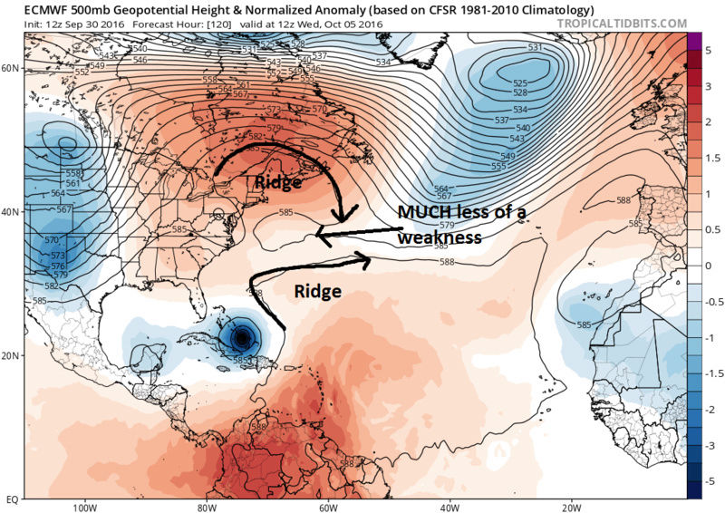
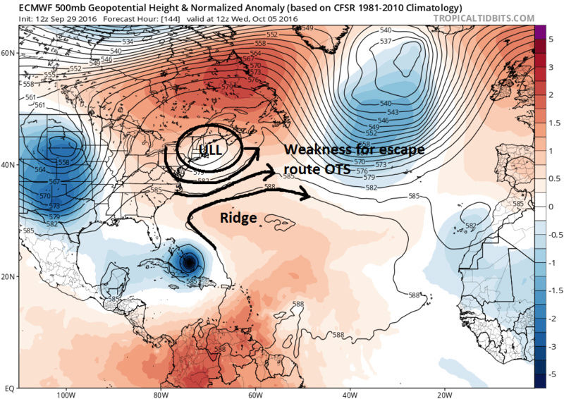
Follow the upper level low over centered over Indiana/Ohio border in the first image below.


Now look at the last two frames from todays run above and compare to 12z yesterdays runs for the same time frame. upper level low is still over the NE creating a weakness and and escape route. Today it lifts out faster, and the ridge builds in stronger.


_________________
"In weather and in life, there's no winning and losing; there's only winning and learning."
WINTER 2012/2013 TOTALS 43.65"WINTER 2017/2018 TOTALS 62.85" WINTER 2022/2023 TOTALS 4.9"
WINTER 2013/2014 TOTALS 64.85"WINTER 2018/2019 TOTALS 14.25" WINTER 2023/2024 TOTALS 13.1"
WINTER 2014/2015 TOTALS 71.20"WINTER 2019/2020 TOTALS 6.35"
WINTER 2015/2016 TOTALS 35.00"WINTER 2020/2021 TOTALS 37.75"
WINTER 2016/2017 TOTALS 42.25"WINTER 2021/2022 TOTALS 31.65"

sroc4- Admin
- Posts : 8331
Reputation : 301
Join date : 2013-01-07
Location : Wading River, LI
Re: HURRICANE MATTHEW
![]() by sroc4 Fri Sep 30, 2016 2:41 pm
by sroc4 Fri Sep 30, 2016 2:41 pm
YESTERDAY Same time frame:
_________________
"In weather and in life, there's no winning and losing; there's only winning and learning."
WINTER 2012/2013 TOTALS 43.65"WINTER 2017/2018 TOTALS 62.85" WINTER 2022/2023 TOTALS 4.9"
WINTER 2013/2014 TOTALS 64.85"WINTER 2018/2019 TOTALS 14.25" WINTER 2023/2024 TOTALS 13.1"
WINTER 2014/2015 TOTALS 71.20"WINTER 2019/2020 TOTALS 6.35"
WINTER 2015/2016 TOTALS 35.00"WINTER 2020/2021 TOTALS 37.75"
WINTER 2016/2017 TOTALS 42.25"WINTER 2021/2022 TOTALS 31.65"
sroc4- Admin
- Posts : 8331
Reputation : 301
Join date : 2013-01-07
Location : Wading River, LI
Re: HURRICANE MATTHEW
![]() by amugs Fri Sep 30, 2016 2:44 pm
by amugs Fri Sep 30, 2016 2:44 pm
_________________
Mugs
AKA:King: Snow Weenie
Self Proclaimed
WINTER 2014-15 : 55.12" +.02 for 6 coatings (avg. 35")
WINTER 2015-16 Total - 29.8" (Avg 35")
WINTER 2016-17 : 39.5" so far

amugs- Advanced Forecaster - Mod

- Posts : 15093
Reputation : 213
Join date : 2013-01-07
Age : 54
Location : Hillsdale,NJ
Re: HURRICANE MATTHEW
![]() by SoulSingMG Fri Sep 30, 2016 2:53 pm
by SoulSingMG Fri Sep 30, 2016 2:53 pm
amugs wrote:The EURO stalls for 3 days over the Bahamas - BUH BYE !!!
***MALFUNCTION***

SoulSingMG- Senior Enthusiast
- Posts : 2853
Reputation : 74
Join date : 2013-12-11
Location : Long Island City, NY
Re: HURRICANE MATTHEW
![]() by Sanchize06 Fri Sep 30, 2016 2:57 pm
by Sanchize06 Fri Sep 30, 2016 2:57 pm
Sanchize06- Senior Enthusiast
- Posts : 1041
Reputation : 21
Join date : 2013-02-05
Location : Union Beach, NJ
Re: HURRICANE MATTHEW
![]() by SoulSingMG Fri Sep 30, 2016 3:01 pm
by SoulSingMG Fri Sep 30, 2016 3:01 pm
Sanchize06 wrote:Euro actually goes back south toward the Bahamas at hr 240, weird run
...as a 914mb Category F I V E.
SoulSingMG- Senior Enthusiast
- Posts : 2853
Reputation : 74
Join date : 2013-12-11
Location : Long Island City, NY
Re: HURRICANE MATTHEW
![]() by Sanchize06 Fri Sep 30, 2016 3:03 pm
by Sanchize06 Fri Sep 30, 2016 3:03 pm
SoulSingMG wrote:Sanchize06 wrote:Euro actually goes back south toward the Bahamas at hr 240, weird run
...as a 914mb Category F I V E.
The one thing that is interesting about that run is the low that develops around Bermuda weakening the ridge but Matthew doesn't escape OTS, it stalls instead and by the end of the run at hr 240 the low is gone, the ridge re-develops and my guess is if the run were to continue it would start moving north toward the coast. Either way terrible for the Bahamas if it stalls like that
Sanchize06- Senior Enthusiast
- Posts : 1041
Reputation : 21
Join date : 2013-02-05
Location : Union Beach, NJ
rb924119- Meteorologist

- Posts : 6890
Reputation : 194
Join date : 2013-02-06
Age : 32
Location : Greentown, Pa
Re: HURRICANE MATTHEW
![]() by nutleyblizzard Fri Sep 30, 2016 3:22 pm
by nutleyblizzard Fri Sep 30, 2016 3:22 pm
I'm not buying that run Toss it. I'll wait for the ensembles.rb924119 wrote:That EURO run =


nutleyblizzard- Senior Enthusiast
- Posts : 1952
Reputation : 41
Join date : 2014-01-30
Age : 58
Location : Nutley, new jersey
Re: HURRICANE MATTHEW
![]() by weatherwatchermom Fri Sep 30, 2016 3:28 pm
by weatherwatchermom Fri Sep 30, 2016 3:28 pm
thank you for explaining and I see it on this post as well!!sroc4 wrote:TODAY:
YESTERDAY Same time frame:

weatherwatchermom- Senior Enthusiast
- Posts : 3747
Reputation : 77
Join date : 2014-11-25
Age : 60
Location : Hazlet Township, NJ
Re: HURRICANE MATTHEW
![]() by sroc4 Fri Sep 30, 2016 4:00 pm
by sroc4 Fri Sep 30, 2016 4:00 pm

_________________
"In weather and in life, there's no winning and losing; there's only winning and learning."
WINTER 2012/2013 TOTALS 43.65"WINTER 2017/2018 TOTALS 62.85" WINTER 2022/2023 TOTALS 4.9"
WINTER 2013/2014 TOTALS 64.85"WINTER 2018/2019 TOTALS 14.25" WINTER 2023/2024 TOTALS 13.1"
WINTER 2014/2015 TOTALS 71.20"WINTER 2019/2020 TOTALS 6.35"
WINTER 2015/2016 TOTALS 35.00"WINTER 2020/2021 TOTALS 37.75"
WINTER 2016/2017 TOTALS 42.25"WINTER 2021/2022 TOTALS 31.65"
sroc4- Admin
- Posts : 8331
Reputation : 301
Join date : 2013-01-07
Location : Wading River, LI
rb924119- Meteorologist
- Posts : 6890
Reputation : 194
Join date : 2013-02-06
Age : 32
Location : Greentown, Pa
Re: HURRICANE MATTHEW
![]() by weatherwatchermom Fri Sep 30, 2016 4:21 pm
by weatherwatchermom Fri Sep 30, 2016 4:21 pm
bernie rayno
weatherwatchermom- Senior Enthusiast
- Posts : 3747
Reputation : 77
Join date : 2014-11-25
Age : 60
Location : Hazlet Township, NJ
Re: HURRICANE MATTHEW
![]() by jmanley32 Fri Sep 30, 2016 4:42 pm
by jmanley32 Fri Sep 30, 2016 4:42 pm

jmanley32- Senior Enthusiast
- Posts : 20516
Reputation : 108
Join date : 2013-12-12
Age : 42
Location : Yonkers, NY
Re: HURRICANE MATTHEW
![]() by Sanchize06 Fri Sep 30, 2016 4:49 pm
by Sanchize06 Fri Sep 30, 2016 4:49 pm
Sanchize06- Senior Enthusiast
- Posts : 1041
Reputation : 21
Join date : 2013-02-05
Location : Union Beach, NJ
Re: HURRICANE MATTHEW
![]() by jmanley32 Fri Sep 30, 2016 4:49 pm
by jmanley32 Fri Sep 30, 2016 4:49 pm
holy crap and u see that eye mugs ur boy is a beast! Defying all odds in intensity.rb924119 wrote:sroc4 wrote:
Cat 4, anybody....? lol
jmanley32- Senior Enthusiast
- Posts : 20516
Reputation : 108
Join date : 2013-12-12
Age : 42
Location : Yonkers, NY
Re: HURRICANE MATTHEW
![]() by jmanley32 Fri Sep 30, 2016 4:51 pm
by jmanley32 Fri Sep 30, 2016 4:51 pm
I'm speechless the islands are screwed this is go b a cat 5. 140 freaking mph! Wasn't he not even supposed to b a hurricane yet yesterday?Sanchize06 wrote:5 pm update: Now a cat 4, winds all the way up to 140 mph, pressure down to 949mb
jmanley32- Senior Enthusiast
- Posts : 20516
Reputation : 108
Join date : 2013-12-12
Age : 42
Location : Yonkers, NY
Re: HURRICANE MATTHEW
![]() by amugs Fri Sep 30, 2016 4:52 pm
by amugs Fri Sep 30, 2016 4:52 pm
jmanley32 wrote:Wow bernie buying the up coast senario. Didn't even suggest ots. Euro was odd I really hope we do not have stalling system for days 10 days from now. I can't take tracking another 3 wk storm lol. 5pm upgrade to cat 4? Amazing 951mb just nuts.
Ventrice too - comparing to 1938 scenario at worst look at his WSI predictable of ensembles - Shnikkey rooooonies here peeps!!!


HOLY SHT
5 PM ADVISORY 140 MPH 949 MB!!!!!
NO WAY MAN (In a Jamaican voice plesae.
_________________
Mugs
AKA:King: Snow Weenie
Self Proclaimed
WINTER 2014-15 : 55.12" +.02 for 6 coatings (avg. 35")
WINTER 2015-16 Total - 29.8" (Avg 35")
WINTER 2016-17 : 39.5" so far
amugs- Advanced Forecaster - Mod
- Posts : 15093
Reputation : 213
Join date : 2013-01-07
Age : 54
Location : Hillsdale,NJ
Re: HURRICANE MATTHEW
![]() by amugs Fri Sep 30, 2016 4:53 pm
by amugs Fri Sep 30, 2016 4:53 pm
Just wait he will defy all odds and models.
_________________
Mugs
AKA:King: Snow Weenie
Self Proclaimed
WINTER 2014-15 : 55.12" +.02 for 6 coatings (avg. 35")
WINTER 2015-16 Total - 29.8" (Avg 35")
WINTER 2016-17 : 39.5" so far
amugs- Advanced Forecaster - Mod
- Posts : 15093
Reputation : 213
Join date : 2013-01-07
Age : 54
Location : Hillsdale,NJ
Re: HURRICANE MATTHEW
![]() by amugs Fri Sep 30, 2016 4:54 pm
by amugs Fri Sep 30, 2016 4:54 pm
NWS NATIONAL HURRICANE CENTER MIAMI FL AL142016
500 PM EDT FRI SEP 30 2016
Matthew has continued to rapidly strengthen at a remarkable rate
today. AKA means HOLY SHT we did not see this!!!!
A NOAA Hurricane Hunter aircraft recently reported a peak
SFMR wind of 116 kt and flight-level winds of 121 kt. A recent
dropsonde from the aircraft indicated that surface winds are around
120 kt. Based on all of these data, the initial intensity is set to
120 kt, an increase of 55 kt in the last 24 hours. The latest
pressure estimate from the aircraft is 949 mb, a drop of 44 mb since
this time yesterday.
Some additional strengthening is possible in the next 12 hours or
so, and the NHC forecast reflects that possibility, showing 125 kt
at that time. Given the lack of skill of the intensity guidance
thus far, this remains a low confidence forecast, and its possible
this could be conservative. Since Matthew has now become a major
hurricane, eyewall replacement cycles could occur that would lead to
some fluctuations in intensity not shown here. After 12 hours, a
gradual weakening is shown, following the trend of, but above nearly
all of the intensity guidance. Land interaction with Cuba should
lead to additional weakening by day 4, but Matthew is expected to
remain a strong hurricane through the forecast period.
The initial motion is still toward the west-southwest, but the
forward speed has slowed a bit, to around 8 kt. The track forecast
reasoning has not changed, with Matthew expected to turn westward by
12 hours and then gradually turn toward the north in the next 3 to 4
days as the cyclone moves into a weakness in the subtropical ridge.
The track model guidance is in slightly better agreement this cycle
through 3 days, although the ECMWF remains right of and slower than
the rest of the guidance at days 4 and 5. The GFS, HWRF, and
COAMPS-TC are faster and to the left late in the period, although
the GFS has trended slower this cycle. The new NHC track has again
been adjusted a little to the left through 72 hours given the
initial position and motion, and after that time is along the
previous official forecast but slower, following the slower trend in
the guidance this cycle. The NHC forecast is near the middle of the
guidance envelope and is a little to the east of the multi-model
consensus at days 4 and 5.
It is important to remind users that average NHC track forecast
errors are around 175 miles at day 4 and 230 miles at day 5.
Therefore, it is too soon to rule out possible hurricane impacts
from Matthew in Florida.
FORECAST POSITIONS AND MAX WINDS
INIT 30/2100Z 13.5N 71.6W 120 KT 140 MPH
12H 01/0600Z 13.3N 72.8W 125 KT 145 MPH
24H 01/1800Z 13.5N 73.9W 120 KT 140 MPH
36H 02/0600Z 14.1N 74.8W 115 KT 130 MPH
48H 02/1800Z 15.2N 75.6W 110 KT 125 MPH
72H 03/1800Z 18.2N 76.2W 105 KT 120 MPH
96H 04/1800Z 22.0N 76.0W 90 KT 105 MPH
120H 05/1800Z 25.0N 76.0W 90 KT 105 MPH
$$
Forecaster Brennan
_________________
Mugs
AKA:King: Snow Weenie
Self Proclaimed
WINTER 2014-15 : 55.12" +.02 for 6 coatings (avg. 35")
WINTER 2015-16 Total - 29.8" (Avg 35")
WINTER 2016-17 : 39.5" so far
amugs- Advanced Forecaster - Mod
- Posts : 15093
Reputation : 213
Join date : 2013-01-07
Age : 54
Location : Hillsdale,NJ
Re: HURRICANE MATTHEW
![]() by Sanchize06 Fri Sep 30, 2016 4:57 pm
by Sanchize06 Fri Sep 30, 2016 4:57 pm
jmanley32 wrote:I'm speechless the islands are screwed this is go b a cat 5. 140 freaking mph! Wasn't he not even supposed to b a hurricane yet yesterday?Sanchize06 wrote:5 pm update: Now a cat 4, winds all the way up to 140 mph, pressure down to 949mb
Yeah, amazing how quickly this strengthened, really wouldn't be surprised to see a cat 5 for a little while
Sanchize06- Senior Enthusiast
- Posts : 1041
Reputation : 21
Join date : 2013-02-05
Location : Union Beach, NJ
Re: HURRICANE MATTHEW
![]() by amugs Fri Sep 30, 2016 4:59 pm
by amugs Fri Sep 30, 2016 4:59 pm

_________________
Mugs
AKA:King: Snow Weenie
Self Proclaimed
WINTER 2014-15 : 55.12" +.02 for 6 coatings (avg. 35")
WINTER 2015-16 Total - 29.8" (Avg 35")
WINTER 2016-17 : 39.5" so far
amugs- Advanced Forecaster - Mod
- Posts : 15093
Reputation : 213
Join date : 2013-01-07
Age : 54
Location : Hillsdale,NJ
Page 21 of 32 • 1 ... 12 ... 20, 21, 22 ... 26 ... 32 ![]()
|
|
|