
 Search
Long Range Thread 12.0
+30
StatenWx
Dunnzoo
weatherwatchermom
Quietace
dkodgis
mwilli5783
jrollins628
devsman
skinsfan1177
billg315
jmanley32
Snow88
chief7
Dtone
Isotherm
sroc4
docstox12
CPcantmeasuresnow
frank 638
track17
NjWeatherGuy
HectorO
SNOW MAN
rb924119
Math23x7
algae888
snow247
amugs
nutleyblizzard
Frank_Wx
34 posters
Page 40 of 40
Page 40 of 40 •  1 ... 21 ... 38, 39, 40
Re: Long Range Thread 12.0
![]() by sroc4 Mon Dec 19, 2016 7:44 am
by sroc4 Mon Dec 19, 2016 7:44 am
skinsfan1177 wrote:Seems to be a lit of uncertainty about the warm up
Yeah Skins. I noticing a few things in the LR that at first glance look really warm for the east but if you look a little deeper I can see how things aren't quite as bad as they may seem. I may try and do a write up on it tomorrow if someone else doesn't point it out first. Particularly the ridging S of the Aleutians and the Ridging over Scananavia and N Europe and their potential partnership beyond day 10. There are a few diff between the GEFS and EPS as one would expect, but both show a decent signal. IF these two ridges trend stronger poleward as we go on in time they may teleconnect with each other leading to another displacement of arctic air into the mid latitudes. As per usual, however, models may be too quick in doing this. Again I will try and do a write up with some details on this with maps to make this more clear.
sroc4- Admin

- Posts : 8331
Join date : 2013-01-07
Re: Long Range Thread 12.0
![]() by rb924119 Mon Dec 19, 2016 8:29 am
by rb924119 Mon Dec 19, 2016 8:29 am
sroc4 wrote:skinsfan1177 wrote:Seems to be a lit of uncertainty about the warm up
Yeah Skins. I noticing a few things in the LR that at first glance look really warm for the east but if you look a little deeper I can see how things aren't quite as bad as they may seem. I may try and do a write up on it tomorrow if someone else doesn't point it out first. Particularly the ridging S of the Aleutians and the Ridging over Scananavia and N Europe and their potential partnership beyond day 10. There are a few diff between the GEFS and EPS as one would expect, but both show a decent signal. IF these two ridges trend stronger poleward as we go on in time they may teleconnect with each other leading to another displacement of arctic air into the mid latitudes. As per usual, however, models may be too quick in doing this. Again I will try and do a write up with some details on this with maps to make this more clear.
I think I am also going to add to this discussion, maybe later today with a quick video. The progged pattern, mainly as we head close to the New Year and beyond, does not actually scream "warmth" to me for our region.
rb924119- Meteorologist

- Posts : 6889
Join date : 2013-02-06
Re: Long Range Thread 12.0
![]() by Frank_Wx Mon Dec 19, 2016 8:42 am
by Frank_Wx Mon Dec 19, 2016 8:42 am
In my opinion this is what I call a frustrating pattern. SE ridge flexes ahead of storm tracks to our west. The FROPA (frontal passage) then ushers in cold air behind. So when we're cold we are dry, when we're mild it's wet. In my view that's a mild pattern but "mild" may be 5 to 10 degrees above normal which is mainly 50's.
GEFS for Christmas Day

GEFS for January 2nd

1st half of January looks mostly average to me. Not necessarily above average. But the storm track pattern for snowstorms to the coast remains unfavorable for the foreseeable future.
GEFS for Christmas Day
GEFS for January 2nd
1st half of January looks mostly average to me. Not necessarily above average. But the storm track pattern for snowstorms to the coast remains unfavorable for the foreseeable future.
_________________
_______________________________________________________________________________________________________
CLICK HERE to view NJ Strong Snowstorm Classifications

Frank_Wx- Godzilla Seeker
- Posts : 21305
Reputation : 328
Join date : 2013-01-05
Age : 31
Location : Jersey City, NJ -

Re: Long Range Thread 12.0
![]() by algae888 Mon Dec 19, 2016 9:21 am
by algae888 Mon Dec 19, 2016 9:21 am
^^ agree with all the above posts. don't forget we are in prime climo now so +5-10 is mostly low -mid 40's. if we can just get a wave beneath us that is where the s/e ridge can help. also noting on models how one strong HP after another will be over new England and south eastern canada after xmas. some 1040+ HP. so maybe some of those cutters can trend south over the next few days. with hell nino gone temps aren't the problem this year it's storm track. hopefully we can get the track south of us....


algae888- Advanced Forecaster

- Posts : 5311
Reputation : 46
Join date : 2013-02-05
Age : 61
Location : mt. vernon, new york
Re: Long Range Thread 12.0
![]() by Frank_Wx Mon Dec 19, 2016 9:38 am
by Frank_Wx Mon Dec 19, 2016 9:38 am
Those are nice and strong HP's. My only issue is there is no blocking to keep them in place. A storm cutting through the mid-section of the country will easily boot that HP northeast, allowing the SE ridge to surge.
_________________
_______________________________________________________________________________________________________
CLICK HERE to view NJ Strong Snowstorm Classifications
Frank_Wx- Godzilla Seeker
- Posts : 21305
Reputation : 328
Join date : 2013-01-05
Age : 31
Location : Jersey City, NJ -
Re: Long Range Thread 12.0
![]() by algae888 Mon Dec 19, 2016 9:47 am
by algae888 Mon Dec 19, 2016 9:47 am
pv goes from this ...

today
to this in 6 days

and then this 15 days.

so maybe some hope as the vortex elongates.


courtesy of steve d. so maybe some warming on the way?
today
to this in 6 days
and then this 15 days.
so maybe some hope as the vortex elongates.
courtesy of steve d. so maybe some warming on the way?
algae888- Advanced Forecaster
- Posts : 5311
Reputation : 46
Join date : 2013-02-05
Age : 61
Location : mt. vernon, new york
Re: Long Range Thread 12.0
![]() by algae888 Mon Dec 19, 2016 9:49 am
by algae888 Mon Dec 19, 2016 9:49 am
agree frank. hopefully we can get some transient block for a system or two. also these HP tend to hold their ground some at this time of year even without blocking.Frank_Wx wrote:Those are nice and strong HP's. My only issue is there is no blocking to keep them in place. A storm cutting through the mid-section of the country will easily boot that HP northeast, allowing the SE ridge to surge.
algae888- Advanced Forecaster
- Posts : 5311
Reputation : 46
Join date : 2013-02-05
Age : 61
Location : mt. vernon, new york
Re: Long Range Thread 12.0
![]() by algae888 Mon Dec 19, 2016 9:54 am
by algae888 Mon Dec 19, 2016 9:54 am
Aleutian ridge has trended strong the last several days...


algae888- Advanced Forecaster
- Posts : 5311
Reputation : 46
Join date : 2013-02-05
Age : 61
Location : mt. vernon, new york
Re: Long Range Thread 12.0
![]() by sroc4 Mon Dec 19, 2016 10:07 am
by sroc4 Mon Dec 19, 2016 10:07 am
Al I have some serious issue with Steve D's LR write up regarding the strat this morning. I dont have time to get into details, but IMO he either doesnt have a clue on how ity works or he doesnt think his clients do.
_________________
"In weather and in life, there's no winning and losing; there's only winning and learning."
WINTER 2012/2013 TOTALS 43.65"WINTER 2017/2018 TOTALS 62.85" WINTER 2022/2023 TOTALS 4.9"
WINTER 2013/2014 TOTALS 64.85"WINTER 2018/2019 TOTALS 14.25" WINTER 2023/2024 TOTALS 13.1"
WINTER 2014/2015 TOTALS 71.20"WINTER 2019/2020 TOTALS 6.35"
WINTER 2015/2016 TOTALS 35.00"WINTER 2020/2021 TOTALS 37.75"
WINTER 2016/2017 TOTALS 42.25"WINTER 2021/2022 TOTALS 31.65"

sroc4- Admin
- Posts : 8331
Reputation : 301
Join date : 2013-01-07
Location : Wading River, LI
Re: Long Range Thread 12.0
![]() by Frank_Wx Mon Dec 19, 2016 10:12 am
by Frank_Wx Mon Dec 19, 2016 10:12 am
sroc4 wrote:Al I have some serious issue with Steve D's LR write up regarding the strat this morning. I dont have time to get into details, but IMO he either doesnt have a clue on how ity works or he doesnt think his clients do.
Hahaha please do share
_________________
_______________________________________________________________________________________________________
CLICK HERE to view NJ Strong Snowstorm Classifications
Frank_Wx- Godzilla Seeker
- Posts : 21305
Reputation : 328
Join date : 2013-01-05
Age : 31
Location : Jersey City, NJ -
Re: Long Range Thread 12.0
![]() by Frank_Wx Mon Dec 19, 2016 10:15 am
by Frank_Wx Mon Dec 19, 2016 10:15 am
Upper strat is forecasted to get as cold as it was last year


_________________
_______________________________________________________________________________________________________
CLICK HERE to view NJ Strong Snowstorm Classifications
Frank_Wx- Godzilla Seeker
- Posts : 21305
Reputation : 328
Join date : 2013-01-05
Age : 31
Location : Jersey City, NJ -
Re: Long Range Thread 12.0
![]() by sroc4 Mon Dec 19, 2016 2:36 pm
by sroc4 Mon Dec 19, 2016 2:36 pm
Frank_Wx wrote:sroc4 wrote:Al I have some serious issue with Steve D's LR write up regarding the strat this morning. I dont have time to get into details, but IMO he either doesnt have a clue on how ity works or he doesnt think his clients do.
Hahaha please do share
I will when I have a little extra time to write up why I think there are some inaccuracies so others can chime in and we can discuss it a bit further
_________________
"In weather and in life, there's no winning and losing; there's only winning and learning."
WINTER 2012/2013 TOTALS 43.65"WINTER 2017/2018 TOTALS 62.85" WINTER 2022/2023 TOTALS 4.9"
WINTER 2013/2014 TOTALS 64.85"WINTER 2018/2019 TOTALS 14.25" WINTER 2023/2024 TOTALS 13.1"
WINTER 2014/2015 TOTALS 71.20"WINTER 2019/2020 TOTALS 6.35"
WINTER 2015/2016 TOTALS 35.00"WINTER 2020/2021 TOTALS 37.75"
WINTER 2016/2017 TOTALS 42.25"WINTER 2021/2022 TOTALS 31.65"
sroc4- Admin
- Posts : 8331
Reputation : 301
Join date : 2013-01-07
Location : Wading River, LI
Re: Long Range Thread 12.0
![]() by algae888 Mon Dec 19, 2016 2:39 pm
by algae888 Mon Dec 19, 2016 2:39 pm
In all fairness Scott The Vortex does look like it takes a few hits Post 10 days. Yes it's going to strengthen and become strong now but who knows what happens as we move into January. The pattern looks real bad for the next few weeks however we do not have the same base heat as we did last year so as you alluded to in your earlier post maybe not as Torchy.sroc4 wrote:Al I have some serious issue with Steve D's LR write up regarding the strat this morning. I dont have time to get into details, but IMO he either doesnt have a clue on how ity works or he doesnt think his clients do.
algae888- Advanced Forecaster
- Posts : 5311
Reputation : 46
Join date : 2013-02-05
Age : 61
Location : mt. vernon, new york
Re: Long Range Thread 12.0
![]() by Frank_Wx Mon Dec 19, 2016 3:12 pm
by Frank_Wx Mon Dec 19, 2016 3:12 pm
Unfortunately this is a negative double whammy for us. Not only will the PV intensity leading up to New Years, but it will move toward Alaska which will keep our EPO positive and PNA negative. I am seeing some positive news in the mean zonal winds, though, but would rather wait a couple of days to see how real it is.
https://twitter.com/judah47/status/810862533171146753
https://twitter.com/judah47/status/810862533171146753
_________________
_______________________________________________________________________________________________________
CLICK HERE to view NJ Strong Snowstorm Classifications
Frank_Wx- Godzilla Seeker
- Posts : 21305
Reputation : 328
Join date : 2013-01-05
Age : 31
Location : Jersey City, NJ -
Re: Long Range Thread 12.0
![]() by sroc4 Mon Dec 19, 2016 3:16 pm
by sroc4 Mon Dec 19, 2016 3:16 pm
algae888 wrote:In all fairness Scott The Vortex does look like it takes a few hits Post 10 days. Yes it's going to strengthen and become strong now but who knows what happens as we move into January. The pattern looks real bad for the next few weeks however we do not have the same base heat as we did last year so as you alluded to in your earlier post maybe not as Torchy.sroc4 wrote:Al I have some serious issue with Steve D's LR write up regarding the strat this morning. I dont have time to get into details, but IMO he either doesnt have a clue on how ity works or he doesnt think his clients do.
I will disagree with that for now Al, but like you said LR forecasts can still change. My biggest problem is what he is saying about what is happening in the Strat right now.
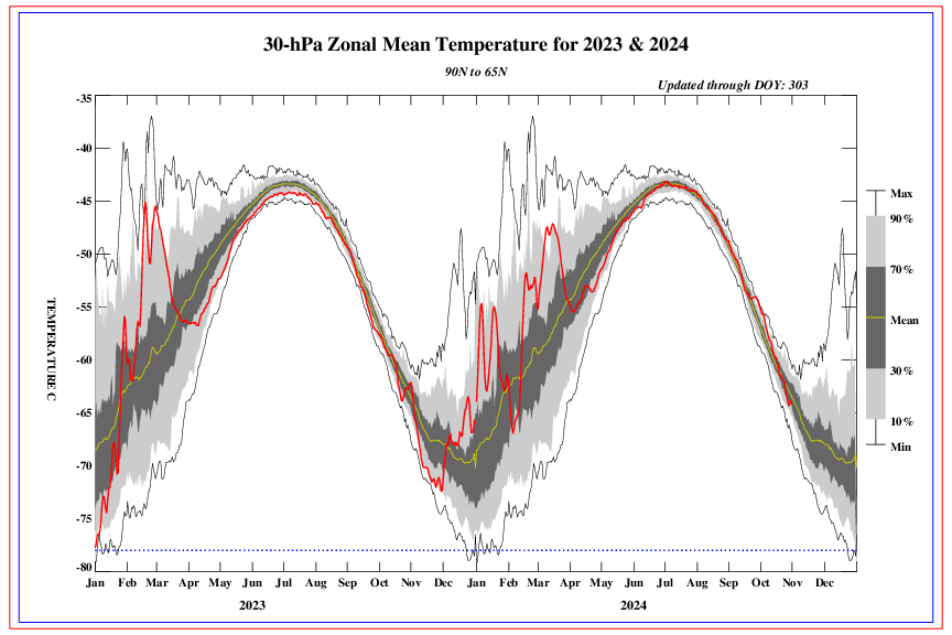
Ladies and gentlemen, I give you support for a warming stratosphere once again. Above is the chart for 70 MB observations which is updated every day after 00Z soundings are retrieved. As you can see, there has been a clear cooling off of the stratosphere at 70 MB and this can be seen up through 1 MB, which is actually averaging below normal. Over the past 5 days, I have been monitoring the warming that has started at 70 MB and this has now extended to 50 MB, and now just this morning 30 MB. The stratospheric cooling is over.
Pay attention to this area circled on all the maps Im about to show. Here is the 70mb map he is refering to: Yes a small spike warmer:

No actually, the strat cooling is just beggining. And no there is not warming at 30 and 50 mb right now nor is there any immediate forecast to. Here is the 30mb chart: Notice it actually just started to trend back towards cold again:
Here is the 10mb chart: Notice it is currently back towards record cold as we speak:
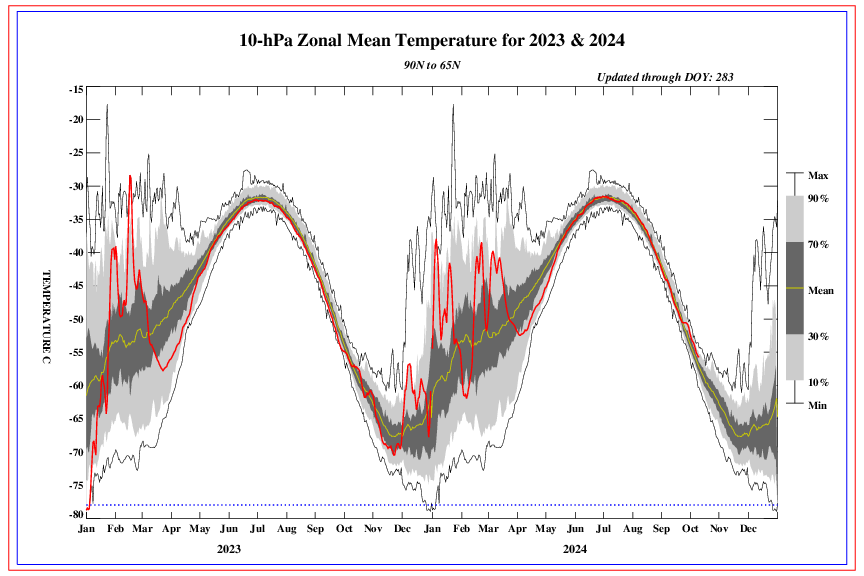
What he may think is warming is this next chart. Notice it says 30mb, but also lotice this chart is for latitudes between 25N and 25S: This is the strat over the tropics. If you look at the other two images I posted they are for 90N to 65N...the Arctic circle. This is where it matters.

The bottom line is there are no true strat warming events that will have any overt effects on the lower troposphere any time soon. The forecast beyond 7-10 has all levels of the strat reconsolidate centered over the N Pole with very little elongation lasting through day 15. Im not saying we cant have an arctic air mass move through but not because of the strat. It would be more likely due to a strong MJO impulse.
Last edited by sroc4 on Thu Dec 29, 2016 8:01 am; edited 1 time in total
_________________
"In weather and in life, there's no winning and losing; there's only winning and learning."
WINTER 2012/2013 TOTALS 43.65"WINTER 2017/2018 TOTALS 62.85" WINTER 2022/2023 TOTALS 4.9"
WINTER 2013/2014 TOTALS 64.85"WINTER 2018/2019 TOTALS 14.25" WINTER 2023/2024 TOTALS 13.1"
WINTER 2014/2015 TOTALS 71.20"WINTER 2019/2020 TOTALS 6.35"
WINTER 2015/2016 TOTALS 35.00"WINTER 2020/2021 TOTALS 37.75"
WINTER 2016/2017 TOTALS 42.25"WINTER 2021/2022 TOTALS 31.65"
sroc4- Admin
- Posts : 8331
Reputation : 301
Join date : 2013-01-07
Location : Wading River, LI
Re: Long Range Thread 12.0
![]() by sroc4 Mon Dec 19, 2016 3:23 pm
by sroc4 Mon Dec 19, 2016 3:23 pm
Frank_Wx wrote:Unfortunately this is a negative double whammy for us. Not only will the PV intensity leading up to New Years, but it will move toward Alaska which will keep our EPO positive and PNA negative. I am seeing some positive news in the mean zonal winds, though, but would rather wait a couple of days to see how real it is.
https://twitter.com/judah47/status/810862533171146753
Your seeing them peak and then trend weaker by about the first right?
_________________
"In weather and in life, there's no winning and losing; there's only winning and learning."
WINTER 2012/2013 TOTALS 43.65"WINTER 2017/2018 TOTALS 62.85" WINTER 2022/2023 TOTALS 4.9"
WINTER 2013/2014 TOTALS 64.85"WINTER 2018/2019 TOTALS 14.25" WINTER 2023/2024 TOTALS 13.1"
WINTER 2014/2015 TOTALS 71.20"WINTER 2019/2020 TOTALS 6.35"
WINTER 2015/2016 TOTALS 35.00"WINTER 2020/2021 TOTALS 37.75"
WINTER 2016/2017 TOTALS 42.25"WINTER 2021/2022 TOTALS 31.65"
sroc4- Admin
- Posts : 8331
Reputation : 301
Join date : 2013-01-07
Location : Wading River, LI
Re: Long Range Thread 12.0
![]() by Frank_Wx Mon Dec 19, 2016 3:26 pm
by Frank_Wx Mon Dec 19, 2016 3:26 pm
Excellent Scott.
Check out today's 12z EURO 10hPa geopotential heights at D10. This thing is a beast. 2800 DM.

December 2015

Now...this is a huge IF and probably not worth posting since it has a high chance of changing, but today's french site shows upper stratospheric warming taking place in the long range. 1hPa winds are forecasted to weaken, and 30hPa geopotential heat flux (wave 1) is expected to increase. EPV at 10hPa remains weak though, so the wave 1 warming is not doing enough in the way of Rosby wave transfer. But honestly, this is likely to change. Just *some* hope.

Check out today's 12z EURO 10hPa geopotential heights at D10. This thing is a beast. 2800 DM.
December 2015
Now...this is a huge IF and probably not worth posting since it has a high chance of changing, but today's french site shows upper stratospheric warming taking place in the long range. 1hPa winds are forecasted to weaken, and 30hPa geopotential heat flux (wave 1) is expected to increase. EPV at 10hPa remains weak though, so the wave 1 warming is not doing enough in the way of Rosby wave transfer. But honestly, this is likely to change. Just *some* hope.
_________________
_______________________________________________________________________________________________________
CLICK HERE to view NJ Strong Snowstorm Classifications
Frank_Wx- Godzilla Seeker
- Posts : 21305
Reputation : 328
Join date : 2013-01-05
Age : 31
Location : Jersey City, NJ -

NjWeatherGuy- Advanced Forecaster
- Posts : 4100
Reputation : 28
Join date : 2013-01-06
Location : Belle Mead, NJ
Page 40 of 40 • 1 ... 21 ... 38, 39, 40
Page 40 of 40
Permissions in this forum:
You cannot reply to topics in this forum|
|
|