
 Search
Long Range Thread 13.0
Page 6 of 40 •  1 ... 5, 6, 7 ... 23 ... 40
 ![]()
Re: Long Range Thread 13.0
![]() by SoulSingMG Fri Jan 27, 2017 7:02 pm
by SoulSingMG Fri Jan 27, 2017 7:02 pm
Grselig wrote:rb924119 wrote:SoulSingMG wrote:LEE GOLDBERG just sounded quiet alarms for "next Super Bowl Sunday into Monday" for a significant snow storm; said many signals have been pointing toward this timeframe for a storm. RARE for him to mention anything this far out.
Oh great....just as the announcer's curse holds true in sports, the TV met's curse will hold for snow storms. So it was written SO SHALL IT BE DONE


SoulSingMG- Senior Enthusiast

- Posts : 2853
Join date : 2013-12-11
Re: Long Range Thread 13.0
![]() by CPcantmeasuresnow Fri Jan 27, 2017 7:27 pm
by CPcantmeasuresnow Fri Jan 27, 2017 7:27 pm
rb924119 wrote:CPcantmeasuresnow wrote:Ronniek wrote:This winter is a bust bring on spring
Stone him, or her.
https://www.youtube.com/watch?v=MIaORknS1Dk
CP WITH THE CLUTCH CLIP ahahahahaha too funny
RB, I'm impressed at age 25 you're even aware of Monty Pythons Life of Brian. Throw the sacreligious aside if possible, just a hysterical movie.
CPcantmeasuresnow- Wx Statistician Guru

- Posts : 7274
Join date : 2013-01-07
Re: Long Range Thread 13.0
![]() by amugs Fri Jan 27, 2017 7:30 pm
by amugs Fri Jan 27, 2017 7:30 pm
Still pretty friggin incredible!!
What is the threshold for a split with the PV even in a so called weaken state?
Tom Frank, Ray Armondo care to answer?
I.know there are variables but in general
_________________
Mugs
AKA:King: Snow Weenie
Self Proclaimed
WINTER 2014-15 : 55.12" +.02 for 6 coatings (avg. 35")
WINTER 2015-16 Total - 29.8" (Avg 35")
WINTER 2016-17 : 39.5" so far

amugs- Advanced Forecaster - Mod

- Posts : 15093
Reputation : 213
Join date : 2013-01-07
Age : 54
Location : Hillsdale,NJ
Re: Long Range Thread 13.0
![]() by weatherwatchermom Fri Jan 27, 2017 7:36 pm
by weatherwatchermom Fri Jan 27, 2017 7:36 pm
SoulSingMG wrote:Grselig wrote:rb924119 wrote:SoulSingMG wrote:LEE GOLDBERG just sounded quiet alarms for "next Super Bowl Sunday into Monday" for a significant snow storm; said many signals have been pointing toward this timeframe for a storm. RARE for him to mention anything this far out.
Oh great....just as the announcer's curse holds true in sports, the TV met's curse will hold for snow storms. So it was written SO SHALL IT BE DONE

weatherwatchermom- Senior Enthusiast
- Posts : 3733
Reputation : 77
Join date : 2014-11-25
Age : 60
Location : Hazlet Township, NJ
Re: Long Range Thread 13.0
![]() by Frank_Wx Fri Jan 27, 2017 7:36 pm
by Frank_Wx Fri Jan 27, 2017 7:36 pm
amugs wrote:SROC oh that was my mistake in bc omnynI caring it to all here. After reaig hin post and what he sent me.
Still pretty friggin incredible!!
What is the threshold for a split with the PV even in a so called weaken state?
Tom Frank, Ray Armondo care to answer?
I.know there are variables but in general
I just posted this on facebook...someone asked me if there's normally another wave attack on the heels of one another.
The short answer is not always, but once you're in late January and February the answer is yes because mean zonal winds, from a climo standpoint, tend to slow down which leaves the PV vulnerable to warming events. Look at the second graph on this chart. Including the current wave 1 event, we've had 2 significant ones so far this winter. Right now, models aren't showing a follow up wave 2 following the current wave 1 so recovery of the Strat PV back over the Pole is possible. However, it's still too soon to say. I actually think a Wave 2 is more likely than a recovery but we'll see. Also notice how the upcoming Wave 1 will be stronger in amplitude than the one we saw late December.

_________________
_______________________________________________________________________________________________________
CLICK HERE to view NJ Strong Snowstorm Classifications

Frank_Wx- Godzilla Seeker

- Posts : 21305
Reputation : 328
Join date : 2013-01-05
Age : 31
Location : Jersey City, NJ -

Re: Long Range Thread 13.0
![]() by rb924119 Fri Jan 27, 2017 8:04 pm
by rb924119 Fri Jan 27, 2017 8:04 pm
CPcantmeasuresnow wrote:rb924119 wrote:CPcantmeasuresnow wrote:Ronniek wrote:This winter is a bust bring on spring
Stone him, or her.
https://www.youtube.com/watch?v=MIaORknS1Dk
CP WITH THE CLUTCH CLIP ahahahahaha too funny
RB, I'm impressed at age 25 you're even aware of Monty Pythons Life of Brian. Throw the sacreligious aside if possible, just a hysterical movie.
I have to be honest and say that I've never seen most of those shows, but I am familiar with the satire haha I have seen parts of Holy Grail, but that's about it. I'm much more well-versed in Mel Brooks lol this is OTI stuff, I know, so we can talk further over there if you wish CP.
rb924119- Meteorologist

- Posts : 6889
Reputation : 194
Join date : 2013-02-06
Age : 32
Location : Greentown, Pa
Re: Long Range Thread 13.0
![]() by essexcountypete Fri Jan 27, 2017 8:41 pm
by essexcountypete Fri Jan 27, 2017 8:41 pm
Indeed, if you sufficiently well versed on Monty Python you would have recognized my avatar at the 500 ft hedgehog named Spiny Norman from the Pirrana Brothers episode.rb924119 wrote:
I have to be honest and say that I've never seen most of those shows, but I am familiar with the satire haha I have seen parts of Holy Grail, but that's about it. I'm much more well-versed in Mel Brooks lol this is OTI stuff, I know, so we can talk further over there if you wish CP.
But seriously, h/t for knowing MP and Mel Brooks.
[Sorry meant to cut and paste into banter]

essexcountypete- Pro Enthusiast

- Posts : 783
Reputation : 12
Join date : 2013-12-09
Location : Bloomfield, NJ
Re: Long Range Thread 13.0
![]() by Isotherm Fri Jan 27, 2017 11:31 pm
by Isotherm Fri Jan 27, 2017 11:31 pm
With respect to the pattern, my confidence continues to grow that this winter is gradually improving rather than a maintenance of status quo. Displacement induced tilting will not be sufficient to force a major zonal wind reversal in the coming days, but reconsolidation will be slow / painful, with IMO, an increasingly likelihood of a follow-up wave-2 convergence about a week or so later. This isn't really being detected by the model data yet, but it should in the coming days. The vortex will be extremely susceptible in early February, and we're entering a regime for further robust driving. When a boxer attempts to knock someone out, it's much easier do to so after several hard punches, rather than waiting until the opponent regains his/her footing and strength. Not too dissimilarly, a delay in follow-up wave driving permits rapid reconsolidation, but the entrance into a propitious precursor regime implies an already depressed vortex state will be threatened with potentially fatal blows.
The first real threat has been 2/6 period to me, but even if that one doesn't work out, I tend to think the tropospheric pattern may become more blocky as we progress into mid / late February. The lack of NAM / NAO cooperation has been detrimental for the East Coast in times of WPO/EPO pulses. Contemporaneous geopotential height response would yield a significantly more auspicious set-up for coastal snowfall. The tropical forcing progression, additionally, looks good to me for renewed ridging near Alaska, after this initial cut-off block retrogrades away.
The long and short of it is as follows: February will be our best month of the meteorological winter this year. The extent to which the sensible weather is pleasing for winter lovers will be largely a function of effective stratospheric activity and other variables. But I am willing to say at this point that February looks much closer to normal temperature wise, with likely at least normal snowfall for the month. March could either resume January's furnace is the strat progression falls apart, or feature a nice late winter regime. 1973-74 still looks great as an analog.
Isotherm- Advanced Forecaster

- Posts : 231
Reputation : 4
Join date : 2014-09-01
Age : 33
Location : Monmouth County, NJ -
Re: Long Range Thread 13.0
![]() by Snow88 Fri Jan 27, 2017 11:37 pm
by Snow88 Fri Jan 27, 2017 11:37 pm
GFS is an inland runner and the CMC is a coastal storm for Feb 6
Those models switched places lol
Many more runs to go

Snow88- Senior Enthusiast
- Posts : 2193
Reputation : 4
Join date : 2013-01-09
Age : 35
Location : Brooklyn, NY
Re: Long Range Thread 13.0
![]() by sroc4 Sat Jan 28, 2017 7:17 am
by sroc4 Sat Jan 28, 2017 7:17 am
With this system essentially we get an area of confluence set up in the east leading to a frontal boundary as a piece of Pac energy moves across the country. Overnight there were three solns. GFS cuts the system west, the CMC gives us the perfect track up the coast and Godzilla, and the euro overnight was a southern slider OTS for our area. The differences is where the confluence is set up at H5, timing and interactions with the N branch, and thus where the boundary layer for which the system will ride is different. Since I do not believe (at least for now) that a southern slider is correct due to the way the trop Pac is setting up, MJO forecasts, I have excluded the euro soln from this discussion for now but I guess the chances aren't zero either. Lets look at GFS then CMC.
On the GFS you can see how the energy associated with the N branch is more in pieces. One that is just about off the map on the right, and a second s/w in S central Canada by 18z Sat the 4th. The N s/w raises heights out ahead of it. This leaves room for, and allows the heights out ahead of our system to increase out ahead of it as well. As these higher heights make it into the NE by the 6th the boundary layer is forced N of the area and the system has room to cut up to our west leading to maybe snow to start, but ultimately changeover to wet and mixed precip.
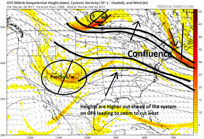

The CMC however offers a diff soln. The key here is again in the handling of the vorticity/energy in the N branch. At H5 at the exact same time frame as the H5 GFS map above notice the energy in the N branch is all one continuous elongated feature. This creates a much more well defined and stronger northern portion of the confluent zone. The strength of this feature prevents heights from rising out ahead of our Pac s/w keeping the flow much flatter. This keeps the boundary layer where we want it such that when the H5 Pac s/w makes it to us the surface LP hits the BM, or near it, with a much more desirable soln.
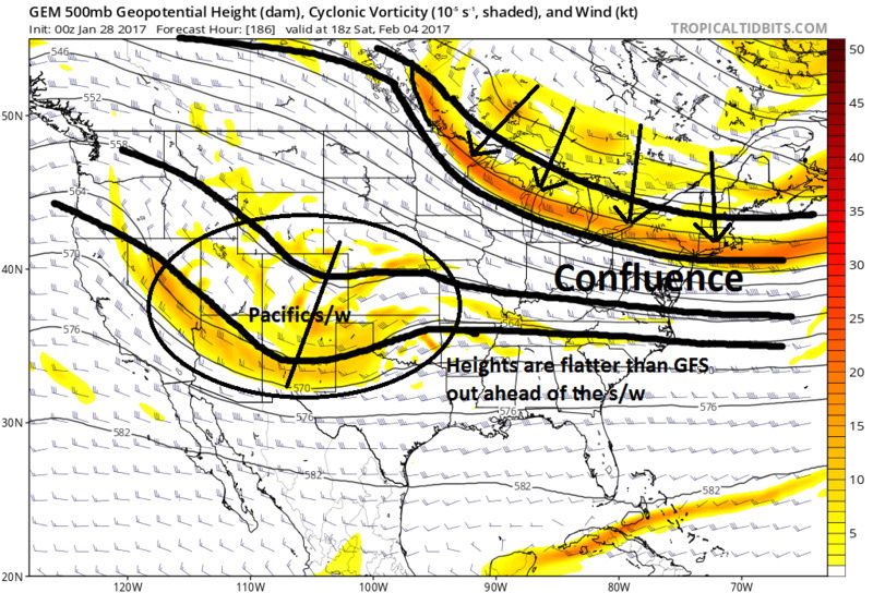

I'm kept it simple for today as there are more to the set up than what I wrote, ie phasing with the N branch and when is one example, that could play a role as well, but since we are still far out one of the first things to nail down is how the confluence sets up.
_________________
"In weather and in life, there's no winning and losing; there's only winning and learning."
WINTER 2012/2013 TOTALS 43.65"WINTER 2017/2018 TOTALS 62.85" WINTER 2022/2023 TOTALS 4.9"
WINTER 2013/2014 TOTALS 64.85"WINTER 2018/2019 TOTALS 14.25" WINTER 2023/2024 TOTALS 13.1"
WINTER 2014/2015 TOTALS 71.20"WINTER 2019/2020 TOTALS 6.35"
WINTER 2015/2016 TOTALS 35.00"WINTER 2020/2021 TOTALS 37.75"
WINTER 2016/2017 TOTALS 42.25"WINTER 2021/2022 TOTALS 31.65"

sroc4- Admin
- Posts : 8331
Reputation : 301
Join date : 2013-01-07
Location : Wading River, LI
Re: Long Range Thread 13.0
![]() by Frank_Wx Sat Jan 28, 2017 8:08 am
by Frank_Wx Sat Jan 28, 2017 8:08 am
_________________
_______________________________________________________________________________________________________
CLICK HERE to view NJ Strong Snowstorm Classifications
Frank_Wx- Godzilla Seeker
- Posts : 21305
Reputation : 328
Join date : 2013-01-05
Age : 31
Location : Jersey City, NJ -
Re: Long Range Thread 13.0
![]() by dkodgis Sat Jan 28, 2017 8:48 am
by dkodgis Sat Jan 28, 2017 8:48 am

dkodgis- Senior Enthusiast
- Posts : 2493
Reputation : 98
Join date : 2013-12-29
Re: Long Range Thread 13.0
![]() by sroc4 Sat Jan 28, 2017 8:53 am
by sroc4 Sat Jan 28, 2017 8:53 am
_________________
"In weather and in life, there's no winning and losing; there's only winning and learning."
WINTER 2012/2013 TOTALS 43.65"WINTER 2017/2018 TOTALS 62.85" WINTER 2022/2023 TOTALS 4.9"
WINTER 2013/2014 TOTALS 64.85"WINTER 2018/2019 TOTALS 14.25" WINTER 2023/2024 TOTALS 13.1"
WINTER 2014/2015 TOTALS 71.20"WINTER 2019/2020 TOTALS 6.35"
WINTER 2015/2016 TOTALS 35.00"WINTER 2020/2021 TOTALS 37.75"
WINTER 2016/2017 TOTALS 42.25"WINTER 2021/2022 TOTALS 31.65"
sroc4- Admin
- Posts : 8331
Reputation : 301
Join date : 2013-01-07
Location : Wading River, LI
Re: Long Range Thread 13.0
![]() by Armando Salvadore Sat Jan 28, 2017 9:20 am
by Armando Salvadore Sat Jan 28, 2017 9:20 am
Isotherm wrote:
With respect to the pattern, my confidence continues to grow that this winter is gradually improving rather than a maintenance of status quo. Displacement induced tilting will not be sufficient to force a major zonal wind reversal in the coming days, but reconsolidation will be slow / painful, with IMO, an increasingly likelihood of a follow-up wave-2 convergence about a week or so later. This isn't really being detected by the model data yet, but it should in the coming days. The vortex will be extremely susceptible in early February, and we're entering a regime for further robust driving. When a boxer attempts to knock someone out, it's much easier do to so after several hard punches, rather than waiting until the opponent regains his/her footing and strength. Not too dissimilarly, a delay in follow-up wave driving permits rapid reconsolidation, but the entrance into a propitious precursor regime implies an already depressed vortex state will be threatened with potentially fatal blows.
The first real threat has been 2/6 period to me, but even if that one doesn't work out, I tend to think the tropospheric pattern may become more blocky as we progress into mid / late February. The lack of NAM / NAO cooperation has been detrimental for the East Coast in times of WPO/EPO pulses. Contemporaneous geopotential height response would yield a significantly more auspicious set-up for coastal snowfall. The tropical forcing progression, additionally, looks good to me for renewed ridging near Alaska, after this initial cut-off block retrogrades away.
The long and short of it is as follows: February will be our best month of the meteorological winter this year. The extent to which the sensible weather is pleasing for winter lovers will be largely a function of effective stratospheric activity and other variables. But I am willing to say at this point that February looks much closer to normal temperature wise, with likely at least normal snowfall for the month. March could either resume January's furnace is the strat progression falls apart, or feature a nice late winter regime. 1973-74 still looks great as an analog.
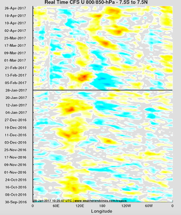
Great info Tom, you've been right on the money since early January. Regarding 200VP, it appears the GEFS has been doing well and the ECMWF is beginning to converge towards the GEFS. Pretty robust coherent MJO wave over the IO/MC as of now. Here is your WWB to begin Feb via the CFS. This will aid towards a much more wintry regime for the east coast and now the 0z EPS has converged more towards the GEFS regarding the medium/LR as it shows heights begin to rise over the west and near the polar regions. Subsequently, following the displacement of the PV, given the lag time.

Armando Salvadore- Advanced Forecaster
- Posts : 171
Reputation : 0
Join date : 2016-12-23
Location : Springfield, NJ
Re: Long Range Thread 13.0
![]() by CPcantmeasuresnow Sat Jan 28, 2017 9:26 am
by CPcantmeasuresnow Sat Jan 28, 2017 9:26 am
dkodgis wrote:Speaking from a "I know nothing" perspective, even I know the jet stream is dipping and the polar vortex may come kiss us with cold. And with that we have several chances for snow. What I also know is just not above I-84. The Time-Space Continuum ends above I-84.
What is going on there? I've had 25 inches of snow so far this season and I'm only 15 miles south of I 84.

CPcantmeasuresnow- Wx Statistician Guru
- Posts : 7274
Reputation : 230
Join date : 2013-01-07
Age : 103
Location : Eastern Orange County, NY
Re: Long Range Thread 13.0
![]() by Armando Salvadore Sat Jan 28, 2017 9:43 am
by Armando Salvadore Sat Jan 28, 2017 9:43 am
Armando Salvadore- Advanced Forecaster
- Posts : 171
Reputation : 0
Join date : 2016-12-23
Location : Springfield, NJ
Re: Long Range Thread 13.0
![]() by SENJsnowman Sat Jan 28, 2017 9:52 am
by SENJsnowman Sat Jan 28, 2017 9:52 am
SENJsnowman- Senior Enthusiast
- Posts : 1186
Reputation : 61
Join date : 2017-01-06
Age : 51
Location : Bayville, NJ
Re: Long Range Thread 13.0
![]() by Frank_Wx Sat Jan 28, 2017 10:06 am
by Frank_Wx Sat Jan 28, 2017 10:06 am
SENJsnowman wrote:The models for the 5th-6th are consistently showing rain along the coast...all the way up to CT really. So, if a coastal storm does develop, what would change our green to blue? Would it have to be a more easterly track that what the coastal track is showing? Is there a chance of colder air coming to the coast? Could this be a storm that creates its own cold air? All of the above? None of the above? I know it's way early and who really knows...but I still want to know if there is a reason for optimism that the Shore gets a Zilla too!
The models are not consistent with anything at this juncture. The 18z GFS went from showing a Godzilla to a rainstorm. The CMC went from showing a rainstorm to a borderline Godzilla. The EURO misses the phases and has no storm. We have a LONG way to go, which is why I rather not analyze H5 maps until Tuesday. By then, the pattern should be better realized.
_________________
_______________________________________________________________________________________________________
CLICK HERE to view NJ Strong Snowstorm Classifications
Frank_Wx- Godzilla Seeker
- Posts : 21305
Reputation : 328
Join date : 2013-01-05
Age : 31
Location : Jersey City, NJ -
Re: Long Range Thread 13.0
![]() by SENJsnowman Sat Jan 28, 2017 10:24 am
by SENJsnowman Sat Jan 28, 2017 10:24 am
I really appreciate the great info you all share. I can only follow a small part of the X's and O's, but here and there I add one or two more pieces to the puzzle.
SENJsnowman- Senior Enthusiast
- Posts : 1186
Reputation : 61
Join date : 2017-01-06
Age : 51
Location : Bayville, NJ
Re: Long Range Thread 13.0
![]() by Snow88 Sat Jan 28, 2017 11:26 am
by Snow88 Sat Jan 28, 2017 11:26 am
Snow88- Senior Enthusiast
- Posts : 2193
Reputation : 4
Join date : 2013-01-09
Age : 35
Location : Brooklyn, NY
Re: Long Range Thread 13.0
![]() by Snow88 Sat Jan 28, 2017 11:29 am
by Snow88 Sat Jan 28, 2017 11:29 am
Snow88- Senior Enthusiast
- Posts : 2193
Reputation : 4
Join date : 2013-01-09
Age : 35
Location : Brooklyn, NY
Re: Long Range Thread 13.0
![]() by Snow88 Sat Jan 28, 2017 11:48 am
by Snow88 Sat Jan 28, 2017 11:48 am
Snow88- Senior Enthusiast
- Posts : 2193
Reputation : 4
Join date : 2013-01-09
Age : 35
Location : Brooklyn, NY
Re: Long Range Thread 13.0
![]() by frank 638 Sat Jan 28, 2017 11:58 am
by frank 638 Sat Jan 28, 2017 11:58 am
frank 638- Senior Enthusiast
- Posts : 2824
Reputation : 37
Join date : 2016-01-01
Age : 40
Location : bronx ny
Re: Long Range Thread 13.0
![]() by sroc4 Sat Jan 28, 2017 12:06 pm
by sroc4 Sat Jan 28, 2017 12:06 pm
frank 638 wrote:Does this mean rain to the coast and snow well inland or we get a nice snowstorm for everyone for the super bowl storm
Way to early for those details. H5 looked great on both CMC and GFS for being 7days out.
_________________
"In weather and in life, there's no winning and losing; there's only winning and learning."
WINTER 2012/2013 TOTALS 43.65"WINTER 2017/2018 TOTALS 62.85" WINTER 2022/2023 TOTALS 4.9"
WINTER 2013/2014 TOTALS 64.85"WINTER 2018/2019 TOTALS 14.25" WINTER 2023/2024 TOTALS 13.1"
WINTER 2014/2015 TOTALS 71.20"WINTER 2019/2020 TOTALS 6.35"
WINTER 2015/2016 TOTALS 35.00"WINTER 2020/2021 TOTALS 37.75"
WINTER 2016/2017 TOTALS 42.25"WINTER 2021/2022 TOTALS 31.65"
sroc4- Admin
- Posts : 8331
Reputation : 301
Join date : 2013-01-07
Location : Wading River, LI
Re: Long Range Thread 13.0
![]() by skinsfan1177 Sat Jan 28, 2017 12:14 pm
by skinsfan1177 Sat Jan 28, 2017 12:14 pm

skinsfan1177- Senior Enthusiast
- Posts : 4485
Reputation : 35
Join date : 2013-01-07
Age : 46
Location : Point Pleasant Boro
Re: Long Range Thread 13.0
![]() by amugs Sat Jan 28, 2017 12:24 pm
by amugs Sat Jan 28, 2017 12:24 pm
frank 638 wrote:Does this mean rain to the coast and snow well inland or we get a nice snowstorm for everyone for the super bowl storm
Frank it is a long way out as Frank (Emperor) has stated a few posts above. Could you imagine another Super Bowl Storm - that would make 3 out of the last 4 years we have had one!
Tom honking - awesome sign and excellent write up thank you for sharing you thoughts here for us to use our webster dictionaries - LOL!!
Everyone wants NAO block but I have to say it has been the most elusive feature since I joined on any forum in 2011. One things I have learned though it can poop up 72 hours before the storm as we have seen over these past few years.
From Earthlight - great gif showing the PNA ridge in the west and teh retrogression of the aleutian Ridge
file:///jhomenuk/status/825357477843697664
_________________
Mugs
AKA:King: Snow Weenie
Self Proclaimed
WINTER 2014-15 : 55.12" +.02 for 6 coatings (avg. 35")
WINTER 2015-16 Total - 29.8" (Avg 35")
WINTER 2016-17 : 39.5" so far
amugs- Advanced Forecaster - Mod
- Posts : 15093
Reputation : 213
Join date : 2013-01-07
Age : 54
Location : Hillsdale,NJ
Re: Long Range Thread 13.0
![]() by amugs Sat Jan 28, 2017 12:55 pm
by amugs Sat Jan 28, 2017 12:55 pm
A very good progression and sign for this month. Models are still lagging with this so we'll see!

_________________
Mugs
AKA:King: Snow Weenie
Self Proclaimed
WINTER 2014-15 : 55.12" +.02 for 6 coatings (avg. 35")
WINTER 2015-16 Total - 29.8" (Avg 35")
WINTER 2016-17 : 39.5" so far
amugs- Advanced Forecaster - Mod
- Posts : 15093
Reputation : 213
Join date : 2013-01-07
Age : 54
Location : Hillsdale,NJ
Page 6 of 40 • 1 ... 5, 6, 7 ... 23 ... 40 ![]()
|
|
|